Chūgoku region
Chūgoku region
中国地方 | |
|---|---|
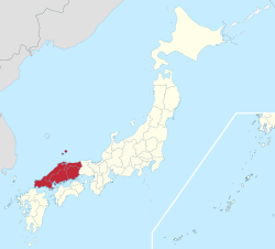 The Chūgoku region in Japan | |
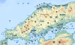 Geofeatures map of Chugoku | |
| Area | |
| • Total | 31,922.26 km2 (12,325.25 sq mi) |
| Population (1 October 2010)[1] | |
| • Total | 7,563,428 |
| • Density | 240/km2 (610/sq mi) |
| Time zone | UTC+9 (JST) |
The Chūgoku region (Japanese: 中国地方, Hepburn: Chūgoku-chihō, pronounced [tɕɯːɡokɯtɕiꜜhoː]), also known as the San'in-San'yō (山陰山陽地方, San'in-San'yō-chihō) region, is the westernmost region of Honshū, the largest island of Japan. It consists of the prefectures of Hiroshima, Okayama, Shimane, Tottori, and Yamaguchi.[2] In 2010, it had a population of 7,563,428.[1]
History[]
Chūgoku literally means "middle country", but the origin of the name is unclear. Historically, Japan was divided into a number of provinces called koku, which were in turn classified according to both their power and their distances from the administrative center in Kansai. Under the latter classification, most provinces are divided into "near countries" (近国, kingoku), "middle countries" (中国, chūgoku), and "far countries" (遠国, ongoku). Therefore, one explanation is that Chūgoku was originally used to refer to the collection of "middle countries" to the west of the capital. However, only five (fewer than half) of the provinces normally considered part of Chūgoku region were in fact classified as middle countries, and the term never applied to the many middle countries to the east of Kansai. Therefore, an alternative explanation is that Chūgoku referred to provinces between Kansai and Kyūshū, which was historically important as the link between Japan and mainland Asia.
Historically, Chūgoku referred to the 16 provinces of San'indō (山陰道) and San'yōdō (山陽道), which led to the region’s alternative name described below. However, because some of the easternmost provinces were later subsumed into prefectures based primarily in Kansai, those areas are, strictly speaking, not part of the Chūgoku region in modern usage.
In Japanese, the characters 中国 and the reading Chūgoku began to be used to mean "China" after the founding of the Republic of China. The same characters are used in Chinese to refer to China, but pronounced Zhōngguó, lit. "Middle Kingdom" or "Middle Country" (Wade Giles: Chung1-kuo2). It is similar to the use of the West Country in English for a region of England.
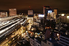
The city of Hiroshima, the "capital" of the Chūgoku region, was rebuilt after being destroyed by an atomic bomb in 1945, and is now an industrial metropolis of more than one million people.
Primarily in the tourism industry, in order to avoid confusing the Chūgoku region with China, the Chūgoku region is also called the "San'in‐San'yō region". San'in ("yīn of the mountains") is the northern part facing the Sea of Japan. San'yō ("yáng of the mountains") is the southern part facing the Seto Inland Sea. These names were created using the yīnyáng‐based place‐naming scheme.
Overfishing and pollution reduced the productivity of the Inland Sea fishing grounds; and San'yo is an area concentrated on heavy industry. In contrast, San'in is less industrialized with an agricultural economy.
Geography[]

The Chūgoku region consists of the following prefectures: Hiroshima, Yamaguchi, Shimane, and Tottori. Okayama is also included, although only Bitchū Province was considered a Middle Country; Mimasaka Province and Bizen Province, the other two components of modern-day Okayama, were considered Near Countries. Kyūshū, Shikoku, and Kansai neighbor the Chūgoku region.
The Chūgoku region is characterized by irregular rolling hills and limited plain areas and is divided into two distinct parts by mountains running east and west through its center.
Demographics[]
The two largest metropolitan areas in Chūgoku region are Hiroshima and Okayama whose total population of the two metropolitan areas amount to 2.808 million as of 2020.[3][4] Their Urban Employment Area amounts to around 3 million people for the Chūgoku region. The rest of Chūgoku region is sparsely populated and very rural.
Per Japanese census data,[5] and,[6] Chūgoku region has had negative population growth since 1992 with some prefectures within the region experiencing negative population growth since 1985.
| Year | Pop. | ±% |
|---|---|---|
| 1920 | 4,971,000 | — |
| 1930 | 5,341,000 | +7.4% |
| 1940 | 5,718,000 | +7.1% |
| 1950 | 6,797,000 | +18.9% |
| 1960 | 6,944,000 | +2.2% |
| 1970 | 6,997,000 | +0.8% |
| 1980 | 7,586,000 | +8.4% |
| 1990 | 7,746,000 | +2.1% |
| 2000 | 7,732,499 | −0.2% |
| 2010 | 7,563,428 | −2.2% |
| 2020 | 7,328,339 | −3.1% |
Cities[]
- Designated cities
- Core cities
- Kurashiki (population: 480,000)
- Fukuyama (population: 460,000)
- Shimonoseki (population: 260,000)
- Kure (population: 220,000)
- Matsue (population: 210,000)
- Tottori (population: 200,000)
Tottori City


- Other major cities
- Yamaguchi (population: 200,000)

Yamaguchi City

Sightseeing[]
- Hiroshima Prefecture: Hiroshima, Miyajima, Fukuyama, Onomichi
- Okayama Prefecture: Okayama, Kurashiki, Takahashi, Tsuyama, Niimi, Bizen, Tamano
- Shimane Prefecture: Tsuwano, Izumo, Matsue, Iwami Ginzan
- Tottori Prefecture: Tottori, Misasa, Daisen, Kurayoshi
- Yamaguchi Prefecture: Shimonoseki, Yamaguchi, Iwakuni, Hofu, Hagi, Akiyoshidai
Fiction[]
- Lian Hearn used a feudal Chūgoku (translated as the Middle Country) as the setting for her Tales of the Otori trilogy.
- In B. Ichi, Chugoku is referred to as "the land of martial arts".
See also[]
- Geography of Japan
- List of regions in Japan
- Names of China
- San'in region
- San'yō region
- Chūgoku dialect and Umpaku dialect
References[]
- ^ Jump up to: a b Ministry of Internal Affairs and Communications Statistics Bureau (26 October 2011). "平成 22 年国勢調査の概要" (PDF). Retrieved 6 May 2012.
- ^ Chugoku Regional Tourism Promotion Association "Overview of Chugoku Region" Archived 2016-08-07 at the Wayback Machine, Chugoku Regional Tourism Portal Site: Navigate Chugoku. Accessed 15 September 2013.
- ^ Hiroshima metro
- ^ Okayama metro
- ^ Hiroshima 1995-2020 population statistics
- ^ Chūgoku region 1920-2000 population statistics
Bibliography[]
 This article incorporates public domain material from the Library of Congress Country Studies document: Ronald E. Dolan and Robert L. Worden (eds.). "Japan".CS1 maint: extra text: authors list (link)
- Tony Gibb By Bike around Chugoku
External links[]
| Wikivoyage has a travel guide for Chugoku. |
Coordinates: 35°03′N 134°04′E / 35.050°N 134.067°E


| show Authority control |
|---|
- Chūgoku region