Japanese archipelago
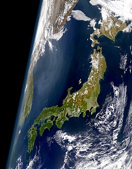 A satellite image of the main archipelago (Sakhalin and Ryukyu Islands not pictured) | |
| Geography | |
|---|---|
| Coordinates | 37°30′52″N 137°42′44″E / 37.514444°N 137.712222°ECoordinates: 37°30′52″N 137°42′44″E / 37.514444°N 137.712222°E |
| Administration | |
The Japanese archipelago (Japanese: 日本列島, Nihon rettō) is a group of 6,852 islands that form the country of Japan. It extends over 3,000 km (1,900 mi)[1] from the Sea of Okhotsk in the northwest to the East China and Philippine Seas in the southwest along the Pacific Ocean coast of the Eurasian continent, and consists of three island arcs from north to south: the Northeastern and , and the Ryukyu Island Arc. The Kuril Island Arc, the Daitō Islands, and the Nanpō Islands are not parts of the archipelago.
Japan is the largest island country in East Asia and the fourth-largest island country in the world with 377,975.24 km2 (145,937.06 sq mi).[2][3] It has an exclusive economic zone of 4,470,000 km2 (1,730,000 sq mi).[4]
Terminology[]
The term mainland Japan is used to distinguish the mainland from the remote islands. It is used when referring to the main islands of Hokkaido, Honshu, Kyushu, Shikoku and Okinawa.[5] It included Karafuto Prefecture (Sakhalin) until the end of World War II.
The term Home Islands was used at the end of World War II to define the area of Japan to which its sovereignty and the constitutional rule of the emperor would be restricted.[citation needed] The term is also commonly used today to distinguish the archipelago from Japan's colonies and other territories.[6]
Palaeogeography[]

Japanese archipelago, Sea of Japan and surrounding part of continental East Asia in Early Miocene (23-18 Ma)
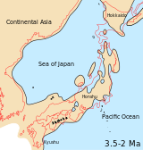
Japanese archipelago, Sea of Japan and surrounding part of continental East Asia in Middle Pliocene to Late Pliocene (3.5-2 Ma)
 Japanese archipelago at the Last Glacial Maximum about 20,000 years ago, thin black line indicates present-day shorelinesVegetated landUnvegetated landOcean

Geography[]
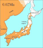
The archipelago consists of 6,852 islands[7] (here defined as land more than 100 m in circumference), of which 430 are inhabited.[8] The six main islands, from north to south, are Sakhalin (a part of the Russian Federation), Hokkaido, Honshu, Shikoku, Kyushu, and Okinawa.[5] Honshu is the largest and referred to as the Japanese mainland.[9]
The topography is divided as:
- Sakhalin, Hokkaido, Honshu, and Shikoku and its surrounding islands;
- Kyushu and the Ryukyu arc , which is composed of the Ryuku Islands and other surrounding islands;
- Eastern part of Hokkaido and the Kuril Islands;
- Nanpō Islands and the Izu Peninsula (part of Izu-Bonin-Mariana Arc).
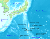
The Nanpō Islands stretch to the southeast and are administered by Tokyo Metropolis

The Ryukyu Islands, which stretch towards Taiwan, are administered by Kagoshima Prefecture and Okinawa Prefecture

Seabed relief map, showing surface and underwater terrain and islands such as Minami-Tori-Shima, Benten-jima, Okinotorishima, and Yonaguni.


See also[]
- Japan in the Paleolithic
- List of islands of Japan
- Extreme points of Japan
References[]
- ^ "Water Supply in Japan". Ministry of Health, Labour and Welfare. Archived from the original (website) on January 26, 2018. Retrieved 26 September 2018.
- ^ "Island Countries Of The World". WorldAtlas.com. Archived from the original on 2017-12-07. Retrieved 2019-08-10.
- ^ "令和元年全国都道府県市区町村別面積調(10月1日時点), Reiwa 1st year National area of each prefecture municipality (as of October 1)" (in Japanese). Geospatial Information Authority of Japan. 26 December 2019. Retrieved 2 January 2020.
- ^ "日本の領海等概念図". 海上保安庁海洋情報部. Archived from the original on August 12, 2018. Retrieved 12 August 2018.
- ^ Jump up to: a b 離島とは(島の基礎知識) [what is a remote island?]. MLIT (Ministry of Land, Infrastructure, Transport and Tourism) (in Japanese). Ministry of Land, Infrastructure, Transport and Tourism. 22 August 2015. Archived from the original (website) on 2007-11-13. Retrieved 9 August 2019.
MILT classification 6,852 islands(main islands: 5 islands, remote islands: 6,847 islands)
- ^ Milton W. Meyer, Japan: A Concise History, 4th ed. Lanham, Maryland: Rowman & Littlefield, 2012, ISBN 9780742541184, p. 2.
- ^ "離島とは(島の基礎知識)". Ministry of Land, Infrastructure, Transport and Tourism. Archived from the original (website) on November 13, 2007. Retrieved 3 October 2018.
- ^ "Islands in Abundance". Look Japan. Vol. 43 no. 493–504. Limited. p. 35.
- ^ "Japanese Archipelago", TheFreeDictionary.com, retrieved 24 June 2013.
| show Authority control |
|---|
- Japanese archipelago
- Archipelagoes of the Pacific Ocean
- Archipelagoes of Japan
- Geography of Japan