Sea of Okhotsk
| Sea of Okhotsk | |
|---|---|
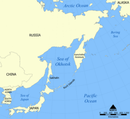 Map of the Sea of Okhotsk | |
| Location | North Asia and East Asia |
| Coordinates | 55°N 150°E / 55°N 150°ECoordinates: 55°N 150°E / 55°N 150°E |
| Type | Sea |
| Basin countries | Japan and Russia |
| Surface area | 1,583,000 km2 (611,200 sq mi) |
| Average depth | 859 m (2,818 ft) |
| Max. depth | 3,372 m (11,063 ft) |

The Sea of Okhotsk (Russian: Охо́тское мо́ре, tr. Okhótskoye móre pronounced [ɐˈxot͡skəjə ˈmorʲe];[a] Japanese: オホーツク海, romanized: Ohōtsuku-kai) is a marginal sea of the western Pacific Ocean.[1] It is located between Russia's Kamchatka Peninsula on the east, the Kuril Islands on the southeast, Japan's island of Hokkaido on the south, the island of Sakhalin along the west, and a stretch of eastern Siberian coast along the west and north. The northeast corner is the Shelikhov Gulf. The sea is named after Okhotsk, the first Russian settlement in the Far East.
Geography[]

The Sea of Okhotsk covers an area of 1,583,000 square kilometres (611,000 sq mi), with a mean depth of 859 metres (2,818 ft) and a maximum depth of 3,372 metres (11,063 ft). It is connected to the Sea of Japan on either side of Sakhalin: on the west through the Sakhalin Gulf and the Gulf of Tartary; on the south through the La Pérouse Strait.
In winter, navigation on the Sea of Okhotsk is impeded by ice floes.[2] Ice floes form due to the large amount of freshwater from the Amur River, lowering the salinity of upper levels, often raising the freezing point of the sea surface. The distribution and thickness of ice floes depends on many factors: the location, the time of year, water currents, and the sea temperatures.[3]
Cold air from Siberia forms sea ice in the northwestern Sea of Okhotsk. As the ice forms it expels salt into the deeper layers. This heavy water flows east toward the Pacific carrying oxygen and nutrients, supporting abundant sea life. The Sea of Okhotsk has warmed in some places by as much as 3 degrees Celsius since preindustrial times, three times faster than the global mean. Warming inhibits the formation of sea ice and also drives fish populations north. The salmon catch on the northern Japanese coast has fallen 70% in the last 15 years, while the Russian chum salmon catch has quadrupled.[4]
With the exception of Hokkaido, one of the Japanese home islands, the sea is surrounded on all sides by territory administered by the Russian Federation. South Sakhalin and the Kuril islands were administered by Japan until 1945. Japan claims the southern Kuril islands and refers to them as "northern territories".[5]
- Gallery

Nagayevo Bay near Magadan, Russia

Shiretoko National Park on the Sea of Okhotsk coast of Hokkaido, Japan


Extent[]
The International Hydrographic Organization defines the limits of the Sea of Okhotsk as follows:[6]
- On the Southwest. The Northeastern and Northern limits on the Japan Sea [In La Perouse Strait (Sôya Kaikyô). A line joining Sôni Misaki and Nishi Notoro Misaki (45°55'N). From Cape Tuik (51°45'N) to Cape Sushcheva].
- On the Southeast. A line running from Nosyappu Saki (Cape Noshap, 43°23'N) in the Island of Hokusyû (Yezo) through the Kuril or Tisima Islands to Cape Lopatka (South point of Kamchatka) in such a way that all the narrow waters between Hokusyû and Kamchatka are included in the Sea of Okhotsk.
Islands[]
Some of the Sea of Okhotsk's islands are quite large, including Japan's second largest island, Hokkaido, as well as Russia's largest island, Sakhalin. Practically all of the sea's islands are either in coastal waters or belong to the various islands making up the Kuril Islands chain. These fall either under undisputed Japanese or Russian ownership or disputed ownership between Japan and Russia. Iony Island is the only island located in open waters and belongs to the Khabarovsk Krai of the Russian Federation. The majority of the sea's islands are uninhabited making them ideal breeding grounds for seals, sea lions, seabirds, and other sea island fauna. Large colonies, with over a million individuals, of crested auklets use the Sea of Okhotsk as a nesting site.
History[]

Pre-modern[]
The Okhotsk people and the later Ainu culture, a coastal fishing and hunter-gatherer people, were located around the lands surrounding the Sea of Okhotsk, as well as in northern Japan.[7]
European exploration and settlement[]
Russian explorers Ivan Moskvitin and Vassili Poyarkov were the first Europeans to visit the Sea of Okhotsk (and, probably, the island of Sakhalin[8]) in the 1640s. The Dutch captain Maarten Gerritsz Vries in the Breskens entered the Sea of Okhotsk from the south-east in 1643, and charted parts of the Sakhalin coast and Kurile Islands, but failed to realize that either Sakhalin or Hokkaido are islands.
The first and foremost Russian settlement on the shore was the port of Okhotsk, which relinquished commercial supremacy to Ayan in the 1840s. The Russian-American Company all but monopolized the commercial navigation of the sea in the first half of the 19th century.
The Second Kamchatka Expedition under Vitus Bering systematically mapped the entire coast of the sea, starting in 1733. Jean-François de La Pérouse and William Robert Broughton were the first non-Russian European navigators known to have passed through these waters other than Maarten Gerritsz Vries. Ivan Krusenstern explored the eastern coast of Sakhalin in 1805. Mamiya Rinzō and Gennady Nevelskoy determined that Sakhalin was indeed an island separated from the mainland by a narrow strait. The first detailed summary of the hydrology of the Sea of Okhotsk was prepared and published by Stepan Makarov in 1894.
Fishing[]
The Sea of Okhotsk is one of the world's richest in biological resources, with various kinds of fish, shellfish and crabs.
The harsh conditions of crab fishing in the Sea of Okhotsk is the subject of the most famous novel of the Japanese writer Takiji Kobayashi, The Crab Cannery Ship (1929).
Whaling[]
American and European whaleships hunted whales in the sea in the 19th and early 20th centuries. They primarily caught right and bowhead whales. A number of ships were wrecked.[9][10][11][12][13][14]
Modern[]
South Sakhalin was administered by Japan as Karafuto Prefecture from 1907 to 1949. The Kuril islands were Japanese from 1855 and 1875 till the end of World War II in 1945. Afterward the Soviet Union occupied the territory.
During the Cold War, the Sea of Okhotsk was the scene of several successful U.S. Navy operations (including Operation Ivy Bells) to tap Soviet Navy undersea communications cables. These operations were documented in the book Blind Man's Bluff: The Untold Story of American Submarine Espionage. The sea (and surrounding area) were also the scene of the Soviet attack on Korean Air Flight 007 in 1983. The Soviet Pacific Fleet used the sea as a ballistic missile submarine bastion,[15] a strategy that Russia continues.
In the Japanese language, the sea has no traditional Japanese name despite its close location to the Japanese territories and is called Ohōtsuku-kai (オホーツク海), which is a transcription of the Russian name. Additionally, Okhotsk Subprefecture, Hokkaidō which faces the sea, also known as Okhotsk region (オホーツク地方, Ohōtsuku-chihō), is named after the sea.
Oil and gas exploration[]
29 zones of possible oil and gas accumulation have been identified on the Sea of Okhotsk shelf, which runs along the coast. Total reserves are estimated at 3.5 billion tons of equivalent fuel, including 1.2 billion tons of oil and 1.5 billion cubic meters of gas.[16]
On 18 December 2011, the Russian oil drilling rig Kolskaya[17] capsized and sank in a storm in the Sea of Okhotsk, some 124 km (77 mi) from Sakhalin Island, where it was being towed from Kamchatka. Reportedly its pumps failed, causing it to take on water and sink. The platform carried 67 people, of which 14 were rescued by the Magadan and the tugboat Natftogaz-55. The platform was subcontracted to a company working for the Russian energy giant Gazprom.[18][19][20]
Notable seaports[]
- Magadan, Magadan, Russia - population: 95,000
- Palana, Kamchatka, Russia - population: 3,000
- Abashiri, Hokkaido, Japan - population: 38,000
- Monbetsu, Hokkaido, Japan - population: 25,000
- Wakkanai, Hokkaido, Japan - population: 38,000
See also[]
Notes[]
References[]
- ^ Kon-Kee Liu; Larry Atkinson (June 2009). Carbon and Nutrient Fluxes in Continental Margins: A Global Synthesis. Springer. pp. 331–333. ISBN 978-3-540-92734-1. Retrieved 29 November 2010.
- ^ "Sea of Okhotsk - Economic aspects". Encyclopedia Britannica. Retrieved 2019-11-14.
- ^ Watanabe, Tatsuro; Ikeda, Motoyoshi; Wakatsuchi, Masaaki (2004). "Thermohaline effects of the seasonal sea ice cover in the Sea of Okhotsk". Journal of Geophysical Research: Oceans. 109 (C9). Bibcode:2004JGRC..109.9S02W. doi:10.1029/2003JC001905. ISSN 2156-2202.
- ^ "How climate change is triggering a chain reaction that threatens the heart of the Pacific". Washington Post. Retrieved 2019-11-14.. Print 15nov19, pp A1, A12, A13.
- ^ Bruce A. Elleman, Michael R. Nichols and Matthew J. Ouimet, A Historical Reevaluation of America's Role in the Kuril Islands Dispute, Pacific Affairs, Vol. 71, No. 4 (Winter, 1998–1999), pp. 489–504
- ^ Limits of Oceans and Seas (PDF). International Hydrographic Organization. 172 (3rd ed.). 1953. pp. 32–33. Bibcode:1953Natur.172R.484.. doi:10.1038/172484b0. S2CID 36029611. Retrieved 15 June 2020.
- ^ "ウェブマガジン カムイミンタラ ~北海道の風土・文化誌 :オホーツク文化人とモヨロ貝塚 網走 流氷とともにやってきた古代民族の謎とロマンに魅せられた父子三代と研究者たち". kamuimintara.net. Retrieved 2019-07-10.
- ^ Stephan, John J. (1971), Sakhalin: a history, Clarendon Press, p. 11
- ^ Webb, Robert (1988). On the Northwest: Commercial Whaling in the Pacific Northwest 1790–1967. University of British Columbia Press. ISBN 0-7748-0292-8.
- ^ Vaughan, R. (1984). "Historical survey of the European whaling industry". In Arctic Whaling: Proceedings of the International Symposium, pp. 121-145. University of Groningen.
- ^ Charles W. Morgan, of New Bedford, Aug. 23-Sep. 30, 1902, George Blunt White Library (GBWL).
- ^ San Francisco Call (Vol. 106, No. 163, November 10, 1909).
- ^ Starbuck, Alexander (1878). History of the American Whale Fishery from Its Earliest Inception to the year 1876. Castle. ISBN 1-55521-537-8.
- ^ Thrum, T. G. (1909). Hawaiian almanac and annual for 1910. Honolulu, Black & Auld, Printers.
- ^ Acharya, Amitav (March 1988). "The United States Versus the USSR in the Pacific: Trends in the Military Balance". Contemporary Southeast Asia. Institute of Southeast Asian Studies. 9 (4): 293. ISSN 1793-284X. JSTOR 25797972.
- ^ "Magadan Region". Kommersant, Russia's Daily Online. Retrieved January 22, 2007.
- ^ Technical details of the rig can be found here : http://www.rigzone.com/data/rig_detail.asp?rig_id=521 and here: http://www.amngr.ru/index.php/en/services/fleet/kolskaya
- ^ "Russian oil rig sinks, leaving many missing". CNN. December 18, 2011. Retrieved December 18, 2011.
- ^ "Kolskaya Sinks Offshore Russia". Rigzone. Retrieved August 13, 2012.
- ^ "Blog Archive » Rig Kolskaya Lost". Shipwreck Log. December 18, 2011. Retrieved August 13, 2012.
External links[]
| Wikisource has the text of a 1905 New International Encyclopedia article about "Sea of Okhotsk". |
| show Authority control |
|---|
- Sea of Okhotsk
- Marginal seas of the Pacific Ocean
- Seas of Japan
- Seas of Russia
- Pacific Coast of Russia
- Bodies of water of Kamchatka Krai
- Bodies of water of Magadan Oblast
- Bodies of water of Sakhalin Oblast
- Geography of the Russian Far East
- Geography of Northeast Asia
- Geography of Hokkaido
- Temperate Northern Pacific