Camotes Sea
| Camotes Sea | |
|---|---|
 An outrigger on the sea near Olango Island | |
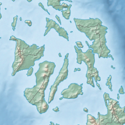 Camotes Sea Location within the Philippines | |
| Location | Visayas |
| Coordinates | 10°30′0″N 124°20′0″E / 10.50000°N 124.33333°ECoordinates: 10°30′0″N 124°20′0″E / 10.50000°N 124.33333°E |
| Type | sea |
| Basin countries | Philippines |
| Settlements | |

The Camotes Sea is a small sea within the Philippine archipelago, situated between the Eastern Visayan and the Central Visayan regions. It is bordered by the islands of Leyte to the north and east, Bohol to the south, and Cebu to the west. It contains the Camotes Islands, Lapinig Island, Olango Island, Mactan Island, and various other small islets.
The sea is connected to the Visayan Sea to the northwest. Southwards, it is connected to the Bohol Sea (also called the Mindanao Sea) in two ways: to the SW by the Cebu Strait (and its 3 channels, the Mactan, the Olango, & the Hilutangan), and to the SE by the Canigao Channel.
The Camotes Sea also contains the Danajon Bank, which is a double barrier reef in the Philippines, which is a very rare geological formation, and there are only 6 double barrier reefs in the world. It comprises two sets of large coral reefs that formed offshore on a submarine ridge due to a combination of favorable tidal currents and coral growth in the area.
Weather patterns[]
The Camotes Sea is subject to quick–changing weather patterns:
As a rule of thumb, the Philippines' Amihan weather pattern (a cool northeast wind) begins sometime in November or December and ends sometime in May or June. There may, however, be wide variations from year to year.[1]
Throughout the rest of the year, the Philippines experiences the west or southwest wind; south west monsoon, which in turn is referred to as the Habagat. The Habagat season is characterized by hot and humid weather, frequent heavy rainfall, and a prevailing wind from the west.
The main indicator of the switch between the Amihan and Habagat seasonal patterns is the switch in wind direction. In most years this transition is abrupt and occurs overnight. In some years there is a period of perhaps a week or two where the wind will switch between Amihan and Habagat patterns several times before settling into the pattern for the new season.
See also[]
- Silot Bay — bay in Liloan, Cebu connected to the sea.
- Danajon Bank — the only double barrier reef of the Philippines.
- Geography of the Visayas — the central island group of the Philippines.
- Cebu Strait — the strait between the islands of Bohol and Cebu, which connects the Bohol Sea (west part) with the Camotes Sea.
- Canigao Channel — the strait between the islands of Bohol and Leyte, which connects the Bohol Sea (east part) with the Camotes Sea.
Seas of the Philippines | ||
|---|---|---|
| Ocean |  | |
| Sea | ||
| Strait |
| |
| Gulf | ||
See also: Bodies of water of the Philippines | ||
References[]
- ^ "Philippines : Weather". Lonely Planet (travel guidebook).
- Seas of the Philippines
- Geography of the Visayas
- Maritime Southeast Asia