Ormoc
Ormoc | |
|---|---|
Independent component city | |
| City of Ormoc | |
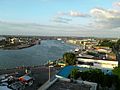
 View of Ormoc from Ormoc Bay | |
 Flag  Seal | |
| Motto(s): Ormoc, Beautiful Land | |
| Anthem: Ormoc, Dutang Matahum (English: Ormoc, Beautiful Land) | |
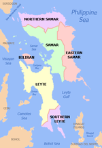
 Map of Leyte with Ormoc highlighted | |
show OpenStreetMap | |
 Ormoc Location within the Philippines | |
| Coordinates: 11°01′N 124°37′E / 11.02°N 124.62°ECoordinates: 11°01′N 124°37′E / 11.02°N 124.62°E | |
| Country | Philippines |
| Region | Eastern Visayas |
| Province | Leyte (geographically only) |
| District | 4th district |
| Founded | February 26, 1834 |
| Cityhood | June 21, 1947 |
| Barangays | 110 (see Barangays) |
| Government | |
| • Type | Sangguniang Panlungsod |
| • Mayor | Richard I. Gomez |
| • Vice Mayor | Leo Carmelo L. Locsin, Jr. |
| • Representative | Lucy Torres Gomez |
| • City Council | show
List |
| • Electorate | 134,487 voters (2019) |
| Area | |
| • Total | 613.60 km2 (236.91 sq mi) |
| Elevation | 234 m (768 ft) |
| Highest elevation | 1,318 m (4,324 ft) |
| Lowest elevation | 0 m (0 ft) |
| Population (2020 census) [3] | |
| • Total | 230,998 |
| • Density | 380/km2 (980/sq mi) |
| • Households | 49,332 |
| Demonym(s) | Ormocanon |
| Economy | |
| • Income class | 1st city income class |
| • Poverty incidence | 29.36% (2015)[4] |
| • Revenue | ₱1,103,766,795.39 (2016) |
| Service provider | |
| • Electricity | Leyte 5 Electric Cooperative (LEYECO 5) |
| Time zone | UTC+8 (PST) |
| ZIP code | 6541 |
| PSGC | |
| IDD : area code | +63 (0)53 |
| Climate type | tropical rainforest climate |
| Native languages | Cebuano Tagalog Waray |
| Website | www |


Ormoc, officially the City of Ormoc (Cebuano: Dakbayan sa Ormoc; Waray: Syudad han Ormoc; Tagalog: Lungsod ng Ormoc), is a 1st class independent component city in the Eastern Visayas region of the Philippines. According to the 2020 census, it has a population of 230,998 inhabitants, [3] making it the second most-populous city in the province after the provincial capital of Tacloban. Ormoc is the economic, cultural, commercial and transportation hub of western Leyte.
Ormoc is an independent component city, not subject to regulation from the Provincial Government of Leyte. However, the city is part of the 4th Congressional District of Leyte together with Albuera, Kananga, Merida, Palompon and Isabel, and statistically grouped under the province by the Philippine Statistics Authority. On November 8, 2013, the city was extensively damaged by Super Typhoon Yolanda (Haiyan), having previously suffered severe destruction and loss of life in 1991 from torrential flooding during Tropical Storm Thelma (Uring).[5]
The city's name is derived from ogmok, an archaic Visayan term for "lowland" or "depressed plain".[6] The city also celebrates an annual thanksgiving festival called the Piña Festival in honor of the saints Peter and Paul in thanks for the bountiful pineapple harvest.[7]
Geography[]
Ormoc City is a port city and is the largest city in Leyte by land area and the second-largest in Eastern Visayas after Calbayog City in Samar. At the head of Ormoc Bay, the city's terrain is mostly of gently rolling plains. It is bounded on the northwest by the towns of Matag-ob and Merida, in the north by Kananga, in the northeast by the towns of Jaro, Pastrana and Dagami, and in the south by the town of Albuera. High mountain ranges separate Ormoc from the eastern portion of Leyte. Numerous rivers and streams traverse Ormoc. Among them are the Bao River in the north, Pagsangahan River in the west, the Bagong-bong River in the south, the Panilahan River also in the south and the Anilao and Malbasag Rivers which border the eastern and western flanks of Ormoc City Proper.[8]
Barangays[]
Ormoc is politically subdivided into 110 barangays.
- Airport
- Alegria
- Alta Vista
- Bagongbong
- Bagong Buhay
- Bantigue
- Barangay District 1 (Pob.)
- Barangay District 2 (Poblacion)
- Barangay District 3 (Poblacion)
- Barangay District 4 (Poblacion)
- Barangay District 5 (Poblacion)
- Barangay District 6 (Poblacion)
- Barangay District 7 (Poblacion)
- Barangay District 8 (Poblacion)
- Barangay District 9 (Poblacion)
- Barangay District 10 (Poblacion)
- Barangay District 11 (Poblacion)
- Barangay District 12 (Poblacion)
- Barangay District 13 (Poblacion)
- Barangay District 14 (Poblacion)
- Barangay District 15 (Poblacion)
- Barangay District 16 (Poblacion)
- Barangay District 17 (Poblacion)
- Barangay District 18 (Poblacion)
- Barangay District 19 (Poblacion)
- Barangay District 20 (Poblacion)
- Barangay District 21 (Poblacion)
- Barangay District 22 (Poblacion)
- Barangay District 23 (Poblacion)
- Barangay District 24 (Poblacion)
- Barangay District 25 (Malbasag) (Poblacion)
- Barangay District 26 (Isla Verde)(Poblacion)
- Barangay District 27 (Poblacion)
- Barangay District 28 (Poblacion)
- Barangay District 29 (Nadongholan) (Poblacion)
- Batuan
- Bayog
- Biliboy
- Cabaon-an
- Cabintan
- Cabulihan
- Cagbuhangin
- Camp Downes
- Can-adieng
- Can-untog
- Catmon
- Cogon Combado
- Concepcion
- Curva
- Danhug (Lili-on)
- Dayhagan
- Dolores
- Domonar
- Don Carlos B. Rivilla Sr. (Boroc)
- Don Felipe Larrazabal
- Don Potenciano Larrazabal
- Doña Feliza Z. Mejia
- Donghol
- Esperanza
- Gaas
- Green Valley
- Guintigui-an
- Hibunawon
- Hugpa
- Ipil
- Juaton
- Kadaohan
- Labrador (Balion)
- Lake Danao
- Lao
- Leondoni
- Libertad
- Liberty
- Licuma
- Liloan
- Linao
- Luna
- Mabato
- Mabini
- Macabug
- Magaswi
- Mahayag
- Mahayahay
- Manlilinao
- Margen
- Mas-in
- Matica-a
- Milagro
- Monterico
- Nasunogan
- Naungan
- Nueva Sociedad
- Nueva Vista
- Patag
- Punta
- Quezon, Jr.
- Rufina M. Tan (Rawis)
- Sabang Bao
- Salvacion
- San Antonio
- San Isidro
- San Jose
- San Juan
- San Pablo (Simangan)
- San Vicente
- Santo Niño
- Sumangga
- Tambulilid
- Tongonan
- Valencia
Climate[]
| hideClimate data for Ormoc City | |||||||||||||
|---|---|---|---|---|---|---|---|---|---|---|---|---|---|
| Month | Jan | Feb | Mar | Apr | May | Jun | Jul | Aug | Sep | Oct | Nov | Dec | Year |
| Average high °C (°F) | 28 (82) |
29 (84) |
29 (84) |
30 (86) |
30 (86) |
30 (86) |
29 (84) |
29 (84) |
29 (84) |
29 (84) |
29 (84) |
29 (84) |
29 (84) |
| Average low °C (°F) | 22 (72) |
22 (72) |
22 (72) |
23 (73) |
25 (77) |
25 (77) |
25 (77) |
25 (77) |
25 (77) |
24 (75) |
24 (75) |
23 (73) |
24 (75) |
| Average precipitation mm (inches) | 78 (3.1) |
57 (2.2) |
84 (3.3) |
79 (3.1) |
118 (4.6) |
181 (7.1) |
178 (7.0) |
169 (6.7) |
172 (6.8) |
180 (7.1) |
174 (6.9) |
128 (5.0) |
1,598 (62.9) |
| Average rainy days | 16.7 | 13.8 | 17.3 | 18.5 | 23.2 | 26.5 | 27.1 | 26.0 | 26.4 | 27.5 | 24.6 | 21.0 | 268.6 |
| Source: Meteoblue (modeled/calculated data, not measured locally)[9] | |||||||||||||
History[]

Ormoc became a city by virtue of Republic Act No. 179 on October 20, 1947, becoming the fifteenth city in the Philippines and the first in the Eastern Visayas region.[10]
Kananga was created in 1950 from the barrios of Lonoy, Kananga, Rizal, Tugbong, Montebello, Aguiting, Tagaytay, Montealegre, Libungao, Naghalin, and Masarayao which all used to be part of Ormoc City.[11]
1991 Flash Flood[]
On the morning of 5 November 1991, the Ormoc region was inundated by Tropical Storm Uring. The city government recorded 4,922 deaths, 3,000 missing persons, 14,000 destroyed houses and more than P600 million worth of damaged property.[12] None of the 3,000 missing persons were ever found and are now presumed dead.[13] Illegal logging and kaingin (slash-and-burn farming) were blamed as the reasons of the flood.[12] Heavy rainfall caused water to collect upstream the Anilao and Malbasag rivers until it poured to the lowlands in Ormoc, particularly District 26, also known as Isla Verde.[12]
On 5 November 2011, a monument by national artist Francis Cinco commemorating the 20th anniversary of the event was inaugurated.[14] It sits on top of the mass grave at the Ormoc City Public Cemetery where an estimated 4,900 victims are buried.[15] The sculpture, entitled "Gift of Life", is an abstract depicting a life taken to heaven.[12][14]
2006 Store Fire[]
A fire at the Unitop store killed 25[16] people on Christmas day. The fire started from firecrackers and pyrotechnics that were ignited near the entrance door. The store did not have a permit to sell firecrackers and emergency exits were locked. The charred remains of the victims were found inside a bathroom, where they tried to escape from the blaze.[17][18]
2013 Super Typhoon Haiyan[]
On November 7, 2013, Typhoon Haiyan, one of the most powerful tropical cyclones ever recorded, made a landfall in the Philippines. While it killed far fewer people as Tropical Storm Uring, it left widespread devastation to the city with destruction and damages in 90% of its structures.[19]
Demographics[]

|
|
| ||||||||||||||||||||||||||||||||||||||||||||||||
| Source: Philippine Statistics Authority [20] [21] [22][23] | ||||||||||||||||||||||||||||||||||||||||||||||||||
The natives of this city are called Ormocanons, with most being Cebuano speakers, as with the whole western and southern parts of the island of Leyte. A definite number of Waray speakers is also present within the city.
Like most Filipinos, Ormocanons are predominantly Roman Catholic, and the city celebrates its annual fiesta in honour of the patron saints Saint Peter and Saint Paul on June 28 and 29. Other main Catholic holy days, including the local fiestas of barangays, are observed throughout the year. There is also a visible Muslim minority within the city and all over the island, evidenced by the mosques within the cityscape and most of them are Maranaos from the twin provinces of Lanao del Norte and Lanao del Sur in Mindanao.[citation needed]
Economy[]

| Poverty Incidence of Ormoc | |
| Source: Philippine Statistics Authority[24][25][26][27][28][29] | |
Ormoc's economic base is a mix of agriculture, aquaculture, industry, tourism, and commercial services. Sugar cane, rice and pineapple are the major agricultural production.
The city enjoys economic growth because it supplies a large part of the country's power needs with its abundant geothermal power resources from the Tongonan Geothermal Power Plant in Barangay Tongonan and the neighbouring Kananga town. Ormoc is also the gateway to the Leyte Industrial Development Estate in the nearby town of Isabel, home of the Philippine Phosphate Fertilizer Plant, the largest fertilizer factory in Asia, and the Philippine Associated Smelter and Refining Company, the country's biggest copper processing plant, among other industries.[citation needed]
Tourism[]
This section is written like a travel guide rather than an encyclopedic description of the subject. (December 2016) |


Among sites visited by the city's tourist are:
- Lake Danao is a violin shaped lake 3 km long at an elevation of 2,100 feet (640 m) above sea level. There are floating cottages, and boats are available for hire and a future zipline. Lake Danao was formerly called as Lake Imelda. On February 3, 1998, it was renamed and declared as Lake Danao National Park and is protected by the National Integrated Protected Area System Act of 1992.[30]
- Tongonan Hotsprings National Park is located at an elevation of 2,000 ft. amid densely forested hills. It is a 272-hectare park at the west end of the Leyte Mountain Trail, 18 km. northeast of Ormoc City. It also has a cool climate, lush tropical vegetation and underbrush, a warm medicinal pool, a cavernous hillside geyser that spouts boiling water and steam hourly and formations exuding sulfuric vapors. It is a valley of geothermal power source that can supply electricity to the whole region. The first geothermal plant to operate in the Philippines.
- Pineapple Plantation lies in 210 hectares in rolling terrain located north of the city Barangay Hibunawon. Ormoc's Queen Pineapple is famous for its sweetness, a favourite pasalubong, and the unofficial icon of the city. The plantation is owned by the Locsins (family of the city vice mayor). Ormoc is known for its famous “Queen Pineapple."[31]
- Centennial Park The Veteran's Park was constructed in early 1990s in honor of the Filipino soldiers who fought for the liberation of Leyte and the Philippines. The Centennial Marker was erected in 1998 to commemorate the 100th year of Philippine independence.The park is located in the city, it is a leisure and picnic ground for the young and old alike.[32]
- Lake Kasudsuran is just one of the three beautiful lakes of Ormoc. It is located at Barangay Gaas, Ormoc City in Leyte. The 5-hectare Lake Kasudsuran is located 27 km (a 45-hr. drive) northeast of Ormoc City on the virgin forest of Barangay Ga-as and Mt. Janagdan, a plateau 1,000 m above sea level. The lake is only accessible by foot. Lake Kasudsuran is also a place to explore in Ormoc City.
- Alto Peak is known as the highest mountain in Eastern Visayas(Region VIII). The domain is also a home to farming communities that has vegetable plantations, etc.[33] It is also known as Mt. Amindueuen and is technically part of the Municipality of Jaro, Leyte but its jump off is in Barangay Cabintan, Ormoc City.
- Sayahan Falls The Sayahan Falls is a newly discovered spot that is located at Sitio Maglahug, Barangay Gaas, Ormoc City. The Sayahan Falls started gaining attention when a local tourist uploaded pictures of it in social media and was widely shared.[34]
- Puente dela Reina is known as the oldest bridge in the city. Its cobblestones still intact, relic of an age long gone. It was built in the early 1800s but was completed in 1861. In Spanish era, the bridge was used as docking area for sailboats, vintas of Chinese, Javans and Indonesians who frequented the island to sell their produce. The bridge is still in use to this day.[35]
- Western Leyte Guerrilla Warfare Forces Monument The Monument commemorates the Filipino resistance fighters who fought in the guerilla war against the Japanese occupiers in the Second World War[36]
- Ruins of Cong. Dominador Tan Residence The Tan Mansion Ruins was built during the 1930s. In World War II, the mansion became a Japanese garrison in Leyte. It was destroyed during the bombing of Ormoc before liberation day, known as the “Battle of Ormoc Bay.”The Tan Mansion Ruins is like a memorial to the Japanese that visits the place. Treated like a shrine as it has a significant part of history of both countries—Japan and Philippines. It serves as a monument representing not only Dominador's young love but also as witness to Ormoc's history.[37]
Infrastructure[]
Transport[]


The Port of Ormoc serves as the seaport of the city. For air transport, Ormoc Airport serves the city.
Energy[]
Ormoc hosts the biggest geothermal power plant in Southeast Asia - the Tongonan Geothermal Power in Barangay Tongonan which supplies electricity not only in the Eastern Visayas Region but power demand in Luzon as well.[citation needed]
Education[]

Ormoc is the educational center for western Leyte. It has a range of primary and secondary schools, both public and private. Tertiary education was originally offered by St. Peter's College of Ormoc, a Benedictine-run Catholic college and the oldest, followed by Western Leyte College of Ormoc City, Inc.,[38] a private non-sectarian college. In the 1990s, the city saw the establishment of Santo Niño College of Ormoc, and the STI College - Ormoc. In the 2000s, tertiary institutions founded were ACLC College of Ormoc, San Lorenzo Ruiz College of Ormoc, Ormoc City Institute of Technology (OCIT) and the Ormoc campus of the Eastern Visayas State University.
Ormoc also has their own Chinese school which is Ormoc Se San School.
Notable people[]
- Johnriel Casimero - professional boxer
- Monica Cuenco - singer, theater actress
- Rey Evangelista - former professional basketball player
- Richard Gomez - actor, Ormoc City mayor
- Chico Lanete and Garvo Lanete - professional basketball players
- Zenaida Monsada - chemist, Department of Energy Officer-in-Charge Secretary
- Lucy Torres Gomez - actress, Congresswoman of 4th District, Leyte
References[]
- ^ City of Ormoc | (DILG)
- ^ "2015 Census of Population, Report No. 3 – Population, Land Area, and Population Density" (PDF). Philippine Statistics Authority. Quezon City, Philippines. August 2016. ISSN 0117-1453. Archived (PDF) from the original on May 25, 2021. Retrieved July 16, 2021.
- ^ Jump up to: a b Census of Population (2020). "Region VIII (Eastern Visayas)". Total Population by Province, City, Municipality and Barangay. PSA. Retrieved 8 July 2021.
- ^ https://psa.gov.ph/sites/default/files/City%20and%20Municipal-level%20Small%20Area%20Poverty%20Estimates_%202009%2C%202012%20and%202015_0.xlsx; publication date: 10 July 2019; publisher: Philippine Statistics Authority.
- ^ "CEBU CEO VISITS ORMOC CITY AND ENGAGES FINANCIAL LITERACY TO COMMON PEOPLE". FINWAZE.com. Archived from the original on 2 April 2019. Retrieved December 13, 2018.
- ^ "Introducing ORMOC". Filipino Homes. Archived from the original on 22 November 2018. Retrieved November 22, 2018.
- ^ "TUGOB, an Ormoc City Festival". bastaigatsikat.com. 26 October 2013. Archived from the original on 10 September 2019. Retrieved November 22, 2018.
- ^ Guia, Jhaypee (13 July 2012). "Ormoc City, Leyte". vigattintourism.com. Archived from the original on 3 December 2018. Retrieved December 3, 2018.
- ^ "Ormoc: Average Temperatures and Rainfall". Meteoblue. Retrieved 29 February 2020.
- ^ "Republic Act No. 179 – An Act Creating Ormoc City". Chan Robles Virtual Law Library. June 21, 1947. Retrieved February 23, 2016.
- ^ "An act creating the municipality of Kananga, Leyte, in the province of Leyte". LawPH.com. Retrieved 9 April 2011.
- ^ Jump up to: a b c d "Ormoc rises from flash flood tragedy". Philippine Daily Inquirer. Retrieved 20 May 2013.
- ^ "Tortured by Typhoons". Retrieved 20 May 2013.
- ^ Jump up to: a b "Monument marks 20th year of Ormoc flashflood tragedy". Philippine Daily Inquirer. Retrieved 20 May 2013.
- ^ "Mass Grave". Fran-Con Viaje International. Retrieved 20 May 2013.
- ^ Dejon, Robert (December 29, 2006). "Death toll in Ormoc fire increases to 25". The Philippine Star. Retrieved December 5, 2019.
- ^ Legaspi, Amita (December 26, 2006). "Christmas Day fire hits Ormoc dep't store; 24 killed, 21 injured". GMA News. Retrieved December 5, 2019.
- ^ Sollano, Jose; Lao, Garry (December 27, 2006). "24 people die in Ormoc store fire". The Philippine Star. Retrieved December 5, 2019.
- ^ Mullany, Gerry (2013-11-14). "Overshadowed by Tacloban, Other Devastated Philippine Cities Fear Aid Will Not Come (Published 2013)". The New York Times. ISSN 0362-4331. Retrieved 2020-10-10.
- ^ Census of Population (2015). "Region VIII (Eastern Visayas)". Total Population by Province, City, Municipality and Barangay. PSA. Retrieved 20 June 2016.
- ^ Census of Population and Housing (2010). "Region VIII (Eastern Visayas)". Total Population by Province, City, Municipality and Barangay. NSO. Retrieved 29 June 2016.
- ^ Censuses of Population (1903–2007). "Region VIII (Eastern Visayas)". Table 1. Population Enumerated in Various Censuses by Province/Highly Urbanized City: 1903 to 2007. NSO.
- ^ "Province of Leyte". Municipality Population Data. Local Water Utilities Administration Research Division. Retrieved 17 December 2016.
- ^ "Poverty incidence (PI):". Philippine Statistics Authority. Retrieved 28 December 2020.
- ^ https://psa.gov.ph/sites/default/files/NSCB_LocalPovertyPhilippines_0.pdf; publication date: 29 November 2005; publisher: Philippine Statistics Authority.
- ^ https://psa.gov.ph/sites/default/files/2003%20SAE%20of%20poverty%20%28Full%20Report%29_1.pdf; publication date: 23 March 2009; publisher: Philippine Statistics Authority.
- ^ https://psa.gov.ph/sites/default/files/2006%20and%202009%20City%20and%20Municipal%20Level%20Poverty%20Estimates_0_1.pdf; publication date: 3 August 2012; publisher: Philippine Statistics Authority.
- ^ https://psa.gov.ph/sites/default/files/2012%20Municipal%20and%20City%20Level%20Poverty%20Estima7tes%20Publication%20%281%29.pdf; publication date: 31 May 2016; publisher: Philippine Statistics Authority.
- ^ https://psa.gov.ph/sites/default/files/City%20and%20Municipal-level%20Small%20Area%20Poverty%20Estimates_%202009%2C%202012%20and%202015_0.xlsx; publication date: 10 July 2019; publisher: Philippine Statistics Authority.
- ^ Piccio, Belle (3 May 2016). "Lake Danao: A Guitar-Shaped Lake in the Province of Leyte". Choose Philippines. Archived from the original on 16 December 2018. Retrieved October 26, 2018.
- ^ Pangilinan, Robbie (3 August 2017). "Ormoc City: Beauty beyond tragedy". The Philippine Star. Archived from the original on 21 February 2019. Retrieved February 21, 2019.
- ^ "WWII Veterans' & Centennial Park". Viaje International. Archived from the original on 3 August 2020. Retrieved October 25, 2018.
- ^ "Alto Peak (1,332+)". Pinoy Mountaineer. Archived from the original on 6 December 2019. Retrieved October 23, 2018.
- ^ "Weekend Adventure to Sayahan Falls Traverse to Lake Kasudsuran". Makoys World. Archived from the original on 22 April 2019. Retrieved November 12, 2018.
- ^ "Heritage Sites of Ormoc". WikiMapia. Archived from the original on 20 February 2020. Retrieved October 17, 2018.
- ^ "Memorial Guerilla Warriors". Traces of War. Archived from the original on 18 October 2020. Retrieved October 29, 2018.
- ^ Piccio, Belle. "Tan Mansion Ruins: A Mansion That Witnessed the Historic Battle of Ormoc". Choose Philippines. Archived from the original on 1 December 2018. Retrieved October 24, 2018.
- ^ WLC-Website
External links[]
| Wikimedia Commons has media related to Ormoc. |
| Wikivoyage has a travel guide for Ormoc. |
- Official website
- Philippine Standard Geographic Code
- Philippine Census of Population
- Local Governance Performance Management System
| show Places adjacent to Ormoc |
|---|
| show Articles Related to Ormoc |
|---|


| show Authority control |
|---|
- Ormoc
- Cities in Leyte (province)
- Independent component cities in the Philippines
- Populated places established in 1834
- 1834 establishments in the Philippines
- Port cities and towns in the Philippines