Caibiran
Caibiran | |
|---|---|
| Municipality of Caibiran | |
 | |
 Flag | |
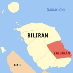 Map of Biliran with Caibiran highlighted | |
OpenStreetMap  | |
 Caibiran Location within the Philippines | |
| Coordinates: 11°34′N 124°35′E / 11.57°N 124.58°ECoordinates: 11°34′N 124°35′E / 11.57°N 124.58°E | |
| Country | Philippines |
| Region | Eastern Visayas |
| Province | Biliran |
| District | Lone district |
| Barangays | 17 (see Barangays) |
| Government | |
| • Type | Sangguniang Bayan |
| • Mayor | Rhodessa D. Revita |
| • Vice Mayor | Linda V. Baleyos |
| • Representative | Gerardo J. Espina Jr. |
| • Councilors | List |
| • Electorate | 16,625 voters (2019) |
| Area | |
| • Total | 83.55 km2 (32.26 sq mi) |
| Elevation | 139 m (456 ft) |
| Highest elevation | 1,294 m (4,245 ft) |
| Lowest elevation | 0 m (0 ft) |
| Population (2020 census) [3] | |
| • Total | 24,167 |
| • Density | 290/km2 (750/sq mi) |
| • Households | 4,767 |
| Economy | |
| • Income class | 5th municipal income class |
| • Poverty incidence | 38.14% (2015)[4] |
| • Revenue | ₱98,524,018.27 (2020) |
| • Assets | ₱231,319,131.06 (2020) |
| • Expenditure | ₱96,579,889.60 (2020) |
| • Liabilities | ₱39,334,384.51 (2020) |
| Service provider | |
| • Electricity | Biliran Electric Cooperative (BILECO) |
| Time zone | UTC+8 (PST) |
| ZIP code | 6548 |
| PSGC | |
| IDD : area code | +63 (0)53 |
| Native languages | Cebuano Waray Tagalog |
| Website | www |

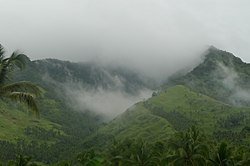
Caibiran (IPA: [kɐʔɪbɪ'ɾan]), officially the Municipality of Caibiran (Waray: Bungto han Caibiran; Cebuano: Lungsod sa Caibiran; Tagalog: Bayan ng Caibiran), is a 5th class municipality in the province of Biliran, Philippines. According to the 2020 census, it has a population of 24,167 people. [3] The town's populace predominantly speak Waray language.
Geography[]
According to the Philippine Statistics Authority, the municipality has a land area of 83.55 square kilometres (32.26 sq mi) [5] constituting 15.59% of the 536.01-square-kilometre- (206.95 sq mi) total area of Biliran.
Barangays[]
Caibiran is politically subdivided into 17 barangays.[6] In 1948, the barangays of Ungale, Tuo, and Inasuyan were transferred to Kawayan, Biliran.[7]
| PSGC | Barangay | Population | ±% p.a. | |||
|---|---|---|---|---|---|---|
| 2020 [3] | 2010 [8] | |||||
| 087804001 | Alegria | 3.2% | 784 | 743 | 0.55% | |
| 087804002 | Asug | 2.3% | 558 | 543 | 0.28% | |
| 087804003 | Bari‑is | 5.2% | 1,257 | 1,212 | 0.38% | |
| 087804004 | Binohangan | 4.3% | 1,044 | 1,059 | −0.15% | |
| 087804005 | Cabibihan | 7.1% | 1,710 | 1,405 | 2.04% | |
| 087804006 | Kawayanon | 1.8% | 430 | 525 | −2.03% | |
| 087804007 | Looc | 2.9% | 703 | 732 | −0.41% | |
| 087804009 | Manlabang | 8.5% | 2,055 | 1,708 | 1.92% | |
| 087804010 | Caulangohan (Marevil) | 2.3% | 554 | 507 | 0.92% | |
| 087804011 | Maurang | 7.8% | 1,878 | 1,683 | 1.13% | |
| 087804012 | Palanay (Poblacion) | 4.5% | 1,089 | 1,138 | −0.45% | |
| 087804013 | Palengke (Poblacion) | 5.6% | 1,357 | 1,601 | −1.69% | |
| 087804014 | Tomalistis | 3.9% | 946 | 916 | 0.33% | |
| 087804015 | Union | 4.6% | 1,116 | 1,026 | 0.87% | |
| 087804016 | Uson | 8.3% | 2,013 | 1,888 | 0.66% | |
| 087804017 | Victory (Poblacion) | 17.0% | 4,102 | 4,013 | 0.23% | |
| 087804018 | Villa Vicenta (Mainit) | 3.8% | 928 | 774 | 1.88% | |
| Total | 24,167 | 21,473 | 1.22% | |||
Climate[]
| Climate data for Caibiran, Biliran | |||||||||||||
|---|---|---|---|---|---|---|---|---|---|---|---|---|---|
| Month | Jan | Feb | Mar | Apr | May | Jun | Jul | Aug | Sep | Oct | Nov | Dec | Year |
| Average high °C (°F) | 28 (82) |
29 (84) |
29 (84) |
31 (88) |
31 (88) |
30 (86) |
30 (86) |
30 (86) |
30 (86) |
29 (84) |
29 (84) |
29 (84) |
30 (85) |
| Average low °C (°F) | 22 (72) |
22 (72) |
22 (72) |
23 (73) |
24 (75) |
25 (77) |
25 (77) |
25 (77) |
25 (77) |
24 (75) |
24 (75) |
23 (73) |
24 (75) |
| Average precipitation mm (inches) | 73 (2.9) |
56 (2.2) |
75 (3.0) |
71 (2.8) |
114 (4.5) |
174 (6.9) |
172 (6.8) |
163 (6.4) |
167 (6.6) |
161 (6.3) |
158 (6.2) |
125 (4.9) |
1,509 (59.5) |
| Average rainy days | 15.2 | 12.5 | 16.2 | 17.3 | 23.9 | 27.3 | 28.4 | 26.9 | 26.9 | 27.1 | 23.8 | 19.3 | 264.8 |
| Source: Meteoblue (Use with caution: this is modeled/calculated data, not measured locally.) [9] | |||||||||||||
Demographics[]
| Year | Pop. | ±% p.a. |
|---|---|---|
| 1903 | 4,091 | — |
| 1918 | 12,767 | +7.88% |
| 1939 | 19,522 | +2.04% |
| 1948 | 21,511 | +1.08% |
| 1960 | 16,963 | −1.96% |
| 1970 | 14,221 | −1.75% |
| 1975 | 16,400 | +2.90% |
| 1980 | 17,004 | +0.73% |
| 1990 | 17,596 | +0.34% |
| 1995 | 18,582 | +1.03% |
| 2000 | 19,606 | +1.16% |
| 2007 | 20,616 | +0.70% |
| 2010 | 21,473 | +1.49% |
| 2015 | 22,524 | +0.91% |
| 2020 | 24,167 | +1.39% |
| Source: Philippine Statistics Authority [10] [8] [11][12] | ||
In the 2020 census, Caibiran had a population of 24,167. [3] The population density was 290 inhabitants per square kilometre (750/sq mi).
Economy[]
| Poverty Incidence of Caibiran | |
| Source: Philippine Statistics Authority[13][14][15][16][17][18] | |
References[]
- ^ Municipality of Caibiran | (DILG)
- ^ "2015 Census of Population, Report No. 3 – Population, Land Area, and Population Density" (PDF). Philippine Statistics Authority. Quezon City, Philippines. August 2016. ISSN 0117-1453. Archived (PDF) from the original on May 25, 2021. Retrieved July 16, 2021.
- ^ a b c d Census of Population (2020). "Region VIII (Eastern Visayas)". Total Population by Province, City, Municipality and Barangay. PSA. Retrieved 8 July 2021.
- ^ https://psa.gov.ph/sites/default/files/City%20and%20Municipal-level%20Small%20Area%20Poverty%20Estimates_%202009%2C%202012%20and%202015_0.xlsx; publication date: 10 July 2019; publisher: Philippine Statistics Authority.
- ^ "Province: Biliran". PSGC Interactive. Quezon City, Philippines: Philippine Statistics Authority. Retrieved 12 November 2016.
- ^ "Municipal: Caibiran". PSGC Interactive. Quezon City, Philippines: Philippine Statistics Authority. Retrieved 8 January 2016.
- ^ "An act to separate the barrios of Ungale, Tuo, and Inasuyan from the municipality of Caibiran, province of Leyte, and to merge these barrios with the municipality of Kawayan, of the same province". LawPH.com. Retrieved 2011-04-08.
- ^ a b Census of Population and Housing (2010). "Region VIII (Eastern Visayas)". Total Population by Province, City, Municipality and Barangay. NSO. Retrieved 29 June 2016.
- ^ "Caibiran: Average Temperatures and Rainfall". Meteoblue. Retrieved 29 February 2020.
- ^ Census of Population (2015). "Region VIII (Eastern Visayas)". Total Population by Province, City, Municipality and Barangay. PSA. Retrieved 20 June 2016.
- ^ Censuses of Population (1903–2007). "Region VIII (Eastern Visayas)". Table 1. Population Enumerated in Various Censuses by Province/Highly Urbanized City: 1903 to 2007. NSO.
- ^ "Province of Biliran". Municipality Population Data. Local Water Utilities Administration Research Division. Retrieved 17 December 2016.
- ^ "Poverty incidence (PI):". Philippine Statistics Authority. Retrieved 28 December 2020.
- ^ https://psa.gov.ph/sites/default/files/NSCB_LocalPovertyPhilippines_0.pdf; publication date: 29 November 2005; publisher: Philippine Statistics Authority.
- ^ https://psa.gov.ph/sites/default/files/2003%20SAE%20of%20poverty%20%28Full%20Report%29_1.pdf; publication date: 23 March 2009; publisher: Philippine Statistics Authority.
- ^ https://psa.gov.ph/sites/default/files/2006%20and%202009%20City%20and%20Municipal%20Level%20Poverty%20Estimates_0_1.pdf; publication date: 3 August 2012; publisher: Philippine Statistics Authority.
- ^ https://psa.gov.ph/sites/default/files/2012%20Municipal%20and%20City%20Level%20Poverty%20Estima7tes%20Publication%20%281%29.pdf; publication date: 31 May 2016; publisher: Philippine Statistics Authority.
- ^ https://psa.gov.ph/sites/default/files/City%20and%20Municipal-level%20Small%20Area%20Poverty%20Estimates_%202009%2C%202012%20and%202015_0.xlsx; publication date: 10 July 2019; publisher: Philippine Statistics Authority.
External links[]
![]() Media related to Caibiran at Wikimedia Commons
Media related to Caibiran at Wikimedia Commons
Places adjacent to Caibiran | ||||||||||||||||
|---|---|---|---|---|---|---|---|---|---|---|---|---|---|---|---|---|
| ||||||||||||||||
| Municipalities | |
|---|---|
This article about a location in Eastern Visayas region is a stub. You can help Wikipedia by . |
- Municipalities of Biliran
- Eastern Visayas geography stubs