Cauayan, Isabela
This article needs additional citations for verification. (January 2014) |
Cauayan | |
|---|---|
Component city | |
| City of Cauayan | |
 Our Lady of the Pillar Church | |
 Flag Seal | |
| Etymology: Bamboo | |
| Nickname(s): Ideal City of the North Mushroom City of the North | |
| Motto(s): Oh, Cauayan | |
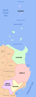
 Map of Isabela with Cauayan highlighted | |
show OpenStreetMap | |
 Cauayan Location within the Philippines | |
| Coordinates: 16°46′N 121°47′E / 16.77°N 121.78°ECoordinates: 16°46′N 121°47′E / 16.77°N 121.78°E | |
| Country | Philippines |
| Region | Cagayan Valley |
| Province | Isabela |
| District | 6th district |
| Founded | 1740 |
| Cityhood | March 30, 2001 |
| Barangays | 65 (see Barangays) |
| Government | |
| • Type | Sangguniang Panlungsod |
| • Mayor | Bernard Faustino L. Dy |
| • Vice Mayor | Leoncio A. Dalin, Jr. |
| • Representative | Faustino A. Dy V |
| • Electorate | 84,058 voters (2019) |
| Area | |
| • Total | 336.40 km2 (129.88 sq mi) |
| Elevation | 65 m (213 ft) |
| Highest elevation | 148 m (486 ft) |
| Lowest elevation | 32 m (105 ft) |
| Population (2020 census) [3] | |
| • Total | 143,403 |
| • Density | 430/km2 (1,100/sq mi) |
| • Households | 30,207 |
| Economy | |
| • Income class | 3rd city income class |
| • Poverty incidence | 12.75% (2015)[4] |
| • Revenue | ₱725,724,086.10 (2016) |
| Service provider | |
| • Electricity | Isabela 1 Electric Cooperative (ISELCO 1) |
| Time zone | UTC+8 (PST) |
| ZIP code | 3305 |
| PSGC | |
| IDD : area code | +63 (0)78 |
| Climate type | tropical rainforest climate |
| Native languages | Ilocano Gaddang Tagalog |
| Website | cityofcauayan |


Cauayan, officially the City of Cauayan (Ilocano: Siudad ti Cauayan; Ibanag: Siudad nat Cauayan; Tagalog: Lungsod ng Cauayan), is a 3rd class component city in the province of Isabela, Philippines. According to the 2020 census, it has a population of 143,403 people. [3]
A small town is founded in 1852 along the Cagayan River and in 2001, converted to a component city. During the Spanish regime, the city is a part of the Tobacco industry. Cauayan is a fast-growing rural industrial center and bordered by 7 neighboring towns which makes it as an important economic center of the province. In the recent years, there is an increase in economic activities.
Etymology[]
Cauayan have its name from the word Kawayan meaning bamboo or bulo in the Ilocano language, the early settlers of the place. How it got its name is vaguely told by the natives. In the tale, early Spaniards reached the place found abundant bamboo trees along creeks that circled the town site of Bulod, Sipat, Bungkol, and Marabulig creeks where few families lived. It was also a common to see crocodiles basking under the cluster of bamboo along the creeks in the early morning sun.
Another version of how the town was named is this way: One day the miraculous image of the Blessed Virgin Mary disappeared. For many weeks, a tireless search was undertaken but it was nowhere to be found. Then one day in October the image was found among the bamboo groves. Not a single sign of mishandling or scratch was detected on the image.
History[]
Cauayan used to be a big municipality in terms of land area. With the creation of the neighboring municipalities of Luna (Antatet) Cabatuan, Reina Mercedes (Callering), Aurora and San Mateo, however, the land area was reduced to about 336.40 square kilometers.
Establishment[]
The original inhabitants (as recorded by the Dominican vicar of Ilagan, Father dela Torre, who explored the area in 1736) were Gaddang.[5] Cauayan town was once a part of the province of Cagayan. When Nueva Vizcaya was created as a province in 1839, Cauayan was transferred to it. On May 1, 1856, the province of Isabela was created by a Royal Decree, Cauayan was again administratively transferred, this time to Isabela. Founded in 1740, Cauayan antedates the establishment of Isabela by 116 years. The town site was first located in a place called Calanusian along the Cagayan River. After a series of disastrous floods, the town site was moved to its present location.[6]
Conversion into a City[]
On February 28, 2001, Republic Act 9017 was signed by then President Gloria Macapagal Arroyo, converting Cauayan into a component city. It was ratified on March 30 of that year, after the voters voted in favor of cityhood.[7] As of 2019, Cauayan is the only settlement in Isabela (and the second in the country after San Isidro, Bohol) to be covered by one district surrounded by another. In this case, Cauayan is part of the 6th district while being surrounded by towns in the 2nd (Reina Mercedes, Naguilian, Benito Soliven and San Mariano), 3rd (Angadanan, Alicia, San Mateo and Cabatuan) and 5th (Luna) districts.
Geography[]
Cauayan City is centrally located in the province and in the entire stretch out of Cagayan Valley. It is about 375 kilometers northeast Manila; 34.5 kilometers south of Ilagan, the capital city of Isabela; about 48 kilometers north Santiago City; and roughly 117 kilometers away from Tuguegarao City in Cagayan Province.
Climate[]
| hideClimate data for Cauayan City | |||||||||||||
|---|---|---|---|---|---|---|---|---|---|---|---|---|---|
| Month | Jan | Feb | Mar | Apr | May | Jun | Jul | Aug | Sep | Oct | Nov | Dec | Year |
| Average high °C (°F) | 29 (84) |
30 (86) |
32 (90) |
35 (95) |
35 (95) |
35 (95) |
34 (93) |
33 (91) |
32 (90) |
31 (88) |
30 (86) |
28 (82) |
32 (90) |
| Average low °C (°F) | 19 (66) |
20 (68) |
21 (70) |
23 (73) |
23 (73) |
24 (75) |
23 (73) |
23 (73) |
23 (73) |
22 (72) |
21 (70) |
20 (68) |
22 (71) |
| Average precipitation mm (inches) | 31.2 (1.23) |
23 (0.9) |
27.7 (1.09) |
28.1 (1.11) |
113.5 (4.47) |
141.4 (5.57) |
176.4 (6.94) |
236.6 (9.31) |
224.9 (8.85) |
247.7 (9.75) |
222.9 (8.78) |
178 (7.0) |
1,651.4 (65) |
| Average rainy days | 10 | 6 | 5 | 5 | 13 | 12 | 15 | 15 | 15 | 17 | 16 | 15 | 144 |
| Source: World Weather Online (modeled/calculated data, not measured locally)[8] | |||||||||||||
Demographics[]
| Year | Pop. | ±% p.a. |
|---|---|---|
| 1903 | 3,954 | — |
| 1918 | 10,083 | +6.44% |
| 1939 | 17,418 | +2.64% |
| 1948 | 20,486 | +1.82% |
| 1960 | 25,744 | +1.92% |
| 1970 | 40,732 | +4.69% |
| 1975 | 47,235 | +3.02% |
| 1980 | 62,224 | +5.66% |
| 1990 | 83,591 | +3.00% |
| 1995 | 92,677 | +1.95% |
| 2000 | 103,952 | +2.49% |
| 2007 | 114,254 | +1.31% |
| 2010 | 122,335 | +2.52% |
| 2015 | 129,523 | +1.09% |
| 2020 | 143,403 | +2.02% |
| Source: Philippine Statistics Authority [9] [10] [11][12] | ||
In the 2020 census, the population of Cauayan, Isabela, was 143,403 people, [3] with a density of 430 inhabitants per square kilometre or 1,100 inhabitants per square mile.
Economy[]
Cauayan is a third class city in the province of Isabela. Cauayan City has been selected to host the Proposed Isabela Special Economic Zone and the Regional Agro-Industrial Growth Center. There are over 2,422 commercial establishments that include distributors, wholesalers and retailers.
Agriculture[]
Cauayan city is a surplus producer of rice and corn. A total of 24,004 hectares or 69.9% hectares is utilized for palay (rice) production and corn production. Average yield per hectare per cropping is 4.5 MT for rice and corn. Other products include livestock and poultry, fruits and vegetables, and fishery products such as hito (cat fish) and tilapia. The National Irrigation Administration has an office in the city.
Banking and finance[]
As of the year December 31, 2015, Cauayan has a total of 30 banks, with a total volume of bank deposits at Php 17.5 billion.[19] There are six banks based in the city namely PR Bank (Philippine Resources Savings Bank), FICO Bank (First Isabela Cooperative Bank), Rural Bank of Cauayan, North Pacific Banking Corp., Common Wealth Rural Bank Inc., and Golden Rural Bank of the Philippines. PR Bank is the largest of this six with 46 branches all over the Philippines,[20] second is FICO Bank with 37 branches in Region 1, 2, 3 & CAR,[21] and third is Rural Bank of Cauayan with 19 branches all within the Cagayan Valley.[22] PR Bank is the 15th largest thrift bank in the Philippines in terms of assets at 9.6 Php billion.[23]
Commerce[]
Recently,[24] SM Prime opened a new mall in Cauayan City, the SM City Cauayan is situated in District II, National highway, Cauayan City, the former site of . SM City Cauayan is the first SM Supermall in Region II which caters at least 1 million residents of the province and neighboring states.[25][26] SM City Cauayan is the first non-premier SM Supermall to offer Al-fresco malling experience, tapping the clean and fresh air that the city has to offer.
SM City Cauayan also delivers new stores, national and international brands, giving Cauayan City and other neighboring towns and cities the opportunity to experience high-end shopping on a vibrant and elegant environment—and most notably is the Japanese clothing line Uniqlo.[27] The Cauayan, Isabela branch of UniQlo is the first in Northern Luzon. KFC, Kenny Rogers,and Max's Restaurant are also expected to open a branch in SM City Cauayan, the companies's first stores in Cagayan Valley. Puregold, a large retail chain in the Philippines, is currently operating two supermarkets in Cauayan. Some notable local shopping centers such as Talavera Square Mall and Primark Town Center Cauayan, which opened in June 2016, has continued to take a significant part of the local commerce industry.
Small Restaurants also made their part to the industry like Kinomo Restaurant, Hap Chan, and is located at San Fermin, Cauayan City.
Big real estate developers like Vista Land and Lifescapes, Inc. also entered the city with the opening of Camella Cauayan and Lumina Cauayan.
Culture[]
Gawagaway-yan Festival of Cauayan City is a celebration of the city's bountiful livelihood and merriment for the ethno-linguistic groups residing in Cauayan. It also traces and gives due recognition to the ancestry of Cauayenos from the ethno linguistic group called Gaddang and recognizes the diversity of the cultural groups residing in Cauayan City through streetdancing, float parade and other indigenous activities.
Cauayan traces its roots to the people of Gaddang, who the city celebrates during the annual festival of Gawagaway-yan. This celebration features a street dance competition, a float parade and assorted activities that different ethno-linguistic groups participate in.
Its ease at growing mushrooms has established Cauayan as the “Mushroom City of the North.” Do not leave the city without visiting the Mushroom Center and trying the delicious local mushrooms cooked in a delightfully unfamiliar way, like tempura, sisig and lumpia.
The city was once tobacco land, and there are still reminders of this past at the Old Tabacalera Warehouse, known as Compania General de Tabacos de Filipinas during the Spanish period. This local tobacco industry was a massive enterprise going all the way back to 1881, when it first started supplying the Tobacco Monopoly of the Spanish government. The old Tabacalera Warehouse is part of Hacienda San Luis,[28] an eco-tourism park in the city.
Aside from the majestic view of Cagayan river from the 250m long and 30 ft high zip line, Hacienda San Luis is a home for cultural heritage. Museo San Luis features how tobaccos are made for the Manila-Acapulco galleon trade. It also showcases sculptures of St. Luis (Louis) and several masterpieces.[29]
Government[]
| Position | Name |
|---|---|
| District Representative (6th Legislative District the Province of Isabela) |
Faustino A. Dy V |
| Chief Executive of the City of Cauayan | Bernard Faustino La Madrid Dy |
| Presiding Officer of the City Council of Cauayan | Vice Mayor Leoncio A. Dalin, Jr. |
| Councilors of the City of Cauayan | Cynthia Bisenta U. Balayan |
| Garry G. Galutera | |
| Edgar M. De Luna | |
| Edgardo A. Atienza Jr. | |
| Telesforo R. Mallillin | |
| Rene Uy | |
| Paul Vincent R. Mauricio | |
| Bagnos A. Maximo, Sr. | |
| Danilo Asirit | |
| Rufino C. Arcega |
Barangays[]
Cauayan City is politically subdivided into 65 barangays.[31]
- Alicaocao
- Amobocan
- Andarayan
- Bacolod
- Baringin Norte
- Baringin Sur
- Buena Suerte
- Bugallon
- Buyon
- Cabaruan
- Cabugao
- Carabatan Chica
- Carabatan Grande
- Carabatan Punta
- Carabatan Bacareno
- Casalatan
- San Pablo
- Cassap Fuera
- Catalina
- Culalabat
- Dabburab
- De Vera
- Dianao
- Dissimuray
- District I (Poblacion)
- District II (Poblacion)
- District III (Poblacion)
- Duminit
- Faustino (Sipay)
- Gagabutan
- Gappal
- Guayabal
- Labinab
- Linglingay
- Mabantad
- Maligaya
- Manaoag
- Marabulig I
- Marabulig II
- Minante I
- Minante II
- Nagcampegan
- Naganacan
- Nagrumbuan
- Nungnungan I
- Nungnungan II
- Pinoma
- Rizaluna
- Rogus
- San Antonio
- San Fermin (Poblacion)
- San Francisco
- San Isidro
- San Luis
- Santa Luciana (Daburab 2)
- Santa Maria
- Sillawit
- Sinippil
- Tagaran
- Turayong
- Union
- Villa Luna
- Villa Concepcion
- Villaflor
Infrastructure[]
In Cauayan City, there is a difference in the adequacy of infrastructure facilities in urban and rural areas. Generally, the closer the area is to the main service center of the city, i.e. the Poblacion, the better are the facilities for production and distribution of goods and services. The analysis in this sector is based on the existing infrastructure facilities and those considered in the pipeline for 2002–2006 implementation. No projects are as yet programmed beyond 2006 in higher levels of government.
Public Transport[]
The existing infrastructure Provision for Transport of Cauayan City is shown in Table 41. The city has a total of 512.27 kilometers of roads. Roads are classified into national, provincial, municipal/city and barangay roads including NIA access roads. All of the 18.16 kilometers of national roads are concrete roads while more than two-thirds of the 42.904 kilometers of Provincial roads are graveled and 17.86 kilometers of city roads are concrete roads, about 97.40% or 340.16 kilometers of barangay roads are gravel roads while the 56.40 kilometers of NIA access road is only 2.22% concrete. By type of pavement, the total of 512.27 kilometers of roads in the city, only 12.37% or 63.322 kilometers is concrete and 87.68% is graveled accounting to 448.948 kilometers. However, all settlement areas are provided with roads.
Roads[]
The national roads allow the operation of various bus and jeepney operators in the City of Cauayan and neighboring towns and areas to transport passengers and cargo to any point of Luzon, making the City of Cauayan one of the transport pivotal points in the Cagayan Valley.
The 18.16 kilometers of national roads in the City of Cauayan provide mobility and access to the neighboring towns, provinces and regions. This road is the Cagayan Valley Road (CVR). The CVR is the Cagayan Valley section of the Philippine-Japan Friendship Highway, also known as the Maharlika Highway.
The CVR from Alinam to Tagaran is the city's longest stretch of concrete road. This road links the City of Cauayan to the rest of the region, to Region 03 and National Capital Region in the south and to Region 01 in the north.
The proposed Cauayan City Diversion Roads include the Minante I- Marabulig-I – Dadap (Mun. of Luna) – San Fermin – Tagaran with an approximate length of 12..5 kilometers; the Alicaocao – Turayong – District II – Labinab – District I – Minante I Diversion Road (4.8 km); and the San Fermin – Tagaran via CRAIGC (4.2 km) These Diversion Roads when constructed will improve the settlements, the movement of goods and services and even the flow of traffic in the city. The estimated construction cost for these tree (3) projects will reach PhP 119.5 million including drainage and 4 bridges.
Of the 59.66 kilometers of provincial roads, only 28.09% or 16.756 kilometers are concrete and the rest are all gravel roads constituting 42.904 kilometers accounting to about 71.91%.
Approximately 61.3% of city streets or 17.860 kilometers are concrete while 38.70% or 10.950 kilometers are gravel roads. In order for business to flourish in the poblacion, all city streets need to be concreted within the plan period.
Of the total 512.27 kilometers of roads within Cauayan, about 11.01% or an aggregate length of 56.40 kilometers is NIA access roads constructed and maintained by the National Irrigation Administration (NIA). However, in 1997, NIA turned over these roads to the city government for maintenance.
The barangay roads are important as they provide mobility and access in the settlement areas. With each new settlement area, barangay roads are initiated with private homeowners’ efforts, provided the road is donated to the government, for concreting and maintenance. The government later on augments the private road development.
Barangay roads totals 349.24 kilometers or 68.17% of the total 512.27 kilometers of roads in the city. Of this length, 97.40% or 340.16 kilometers are graveled. Only about 9.080 kilometers or 2.60% are concrete.
The provision of heavy equipment necessary in the construction and maintenance of roads and other infrastructure facilities and utilities is of high importance in order for the city government to enhance mobility thereby increasing productivity.
Road Density[]
The standards for road provision are 2.40 kilometers for every 1,000 urban population and 1.50 kilometers for every 100 hectares of arable land in the rural areas. Presently, the rural road density (km/km2) is placed at 1.52 topping the list in the entire province in terms of rural road density. With 35.575 kilometers of roads in the 5 barangays with a CY 2000 population of 31,037, the city of Cauayan has an urban road density of only 0.872 kilometers per 1,000 urban populations. Additional roads must be constructed in the poblacion to hasten development. On the other hand, it has 313.665 kilometers in the 60 rural barangays with 23,501.21 hectares of arable land. This means a road density of only 1.33 kilometers for every 100 hectares of arable lands in the rural barangays. This implies that more roads have to be constructed in the rural barangays to fully support socio-economic development.
Bridges[]
The city's road network includes 20 permanent bridges, 6 of which are reinforced concrete deck girder (RCDG) bridges. Thirteen concrete overflow bridges and one steel bridge account for a total aggregate length of 431.5 lineal meters. Two RCDG bridges along the Maharlika highway have recently been replaced under the Tulay ng Pangulo Program of then President Fidel Ramos and were inaugurated in 1999 by no less than President Joseph Estrada. However, The Alicaocao Overflow Bridge spanning 66 meters was hit by disastrous flood in 1998 causing the bridge to collapse particularly at the Carabbatan Chica portion. Replacement of the said bridge is crucial to the development of the other side of the Cagayan River since this is the only route going to that place except when you take Naguilian Bridge via Minanga in the municipality of Naguilian, which is a tormentous stretch aside from causing delay. Several overflow bridges within the city also needs immediate replacement and around 16 bridges and 18 RCCP culverts more need to be constructed/replaced in order to make the city road network system efficient.
Terminals[]
Cauayan road network is supported with privately owned terminals for jeeps and buses located at Barangay San Fermin. SM City Cauayan has built a terminal beside the mall to support the public transportation in/out of the Cauayan.
Bus Companies[]
- Victory Liner
- GV Florida Transport
- Dalin Liner
An inter-provincial bus terminal with an estimated cost of PHP 70.00 million needs to be constructed in this rapidly urbanizing city to improve the effectiveness and efficiency of the city's transportation system and to provide additional prime commercial area and needed tourism support services.
Airport[]

The city airport located at Barangay San Fermin completes the infrastructure provision for transport for the city of Cauayan with provincial and regional impact. It is a secondary airport as per BAT classification. The airport runway has a total length of 2,500 meters and 30 meters wide capable of accommodating Boeing 737s. It is equipped with VHF Omni Range Transmitter, VHF Air/Ground single band radio and provided with fire-fighting equipment and facilities. It is likewise provided with facilities for arriving and departing passengers. The entire airport facility is provided with a perimeter fence.
At present, the facility is undergoing upgrading of facilities intended to accommodate international cargo flights. When completed, it is also expected that normal operations of the Philippine Airlines will resume which is very crucial in the commerce and industry sector of the city. This is very timely since Cauayan City has been selected to host the Proposed Isabela Special Economic Zone and the Regional Agro-Industrial Growth Center.
Cebu Pacific Air fly in Cauayan daily utilizing an Airbus A320 aircraft with Flight No. 5J 196 departing from Manila and Flight No. 5J 197 departing from Cauayan City.
Communication[]
Communications facilities include PLDT, DIGITEL, PILTEL, BAYANTEL, RCPI, PT&T, BUTEL, Globe, Smart and Sun Cellular Communications. Philpost, LBC, JRS Express, FedEx, DCI Express, and EXL Express move mails. Broadcast media is provided by 5 FM and 2 AM station, a cable TV facility while a number of Internet Café have established their operations in the city. Nowadays, the most important means of communication with relatives and friends is thru internet. This was being provided by the NSCV internet connections plus the MYDSL and SmartBro broadband. The LGU likewise is utilizing handheld radio transceivers covering all barangays in city and the province as well with bases at the city hall, city police and fire protection offices.
Health Facilities[]
The health needs of the city is served by a district hospital and 5 private hospitals; RHU-1 & RHU-2, 22 BHS, a puericulture Center, 13 private medical clinics, 11 private dental clinics, a rehabilitation center for the disabled, and the Cauayan Microscopy Center. These medical facilities has a total of 255 beds. Health personnel includes 41 medical doctors, 16 dentist, 74 nurses, 84 midwives, 10 medical technicians, 7 sanitary inspectors, 7 paramedics, 250 Barangay Health Workers and 148 Community Volunteer Health Workers both in the public and private sector.
Education[]
The City Schools Division of Cauayan has a total 64 public and 14 private elementary schools, eight public and seven private secondary schools, two universities and four private colleges.[32]
Colleges:
- Our Lady of the Pillar College-Cauayan
- Isabela State University – Cauayan Campus
- University of Perpetual Help System – Isabela Campus
- Isabela Colleges Incorporated
- Isabela College of Arts and Technology (Marine School)
- System Technology Institute (STI) College
- National Police College Regional Training School
- Saint Clare College of Region 2
- College of Business Education Science and Technology
- East Asia International System College
High schools:
- Cauayan City National High School
- Isabela Colleges Incorporated
- Metropolitan Bible Baptist Learning Center
- Centro De Cultura School
- Merry Sunshine Montessori School
- St. Clare Elementary School – Cauayan
- St. Xavier Montessori School
- Our Lady of the Pillar College – Cauayan
- Nansing School
- University of Perpetual Help System
- United Shepherd Integrated School
- Christian Learning Center
- Children of Lourdes Academy
- Cauayan City National High School Annex
- Pinoma National High School
- San Antonio National High School
- Cauayan City Science & Technology HS (former Villa Luna National High School)
- Villa Conception National High School
- West Tabacal Region National High School
- Sillawit National High School
- Gappal National High School
- Linglingay High School
Elementary schools:
- Cauayan North Central School (District)
- Cauayan Northeast Central School (District)
- Cauayan East Central School (District)
- Cauayan West Central School (District)
- Cauayan South Central School (District) (with SPED and Science Section)
- Bible Baptist Learning Center
- Blessed Faustina MS
- Centro De Cultura School
- Epiphaneia Private School
- Merry Sunshine Montessori School
- Nansing School
- North-East Horizon Institute
- Pilgrims Evangelistic Academy of Christian Academy
- St. Clare Elementary School – Cauayan
- St. Xavier Montessori School
- Children of Lourdes Academy
- Metropolitan Bible Baptist Learning Center
- Cauayan City School of Excellence
- Our Lady of the Pillar College – Cauayan
- Nansing School
- University of Perpetual Help System
- United Shepherds Integrated School
- Christian Learning Center
- Cauayan Messiah United Methodist School
- Alicaocao Elementary School
- Alinam Elementary School
- Amobocan Elementary School
- Andarayan Elementary School
- Bacolod Elementary School
- Baringin Elementary School
- Buena Suerte Elementary School
- Bugallon Elementary School
- Buyon Elementary School
- Cabugao Elementary School
- Casalatan Elementary School
- San Pablo Elementary School
- Cassap Fuera Elementary School
- Catalina Elementary School
- Culalabat Elementary School
- Dabburab Elementary School
- De Vera Elementary School
- Dianao Elementary School
- Dissimuray Elementary School
- Duminit Elementary School
- Faustino Elementary School
- Gagabutan Elementary School
- Gappal Elementary School
- Guayabal Elementary School
- Labinab Elementary School
- Linglingay Elementary School
- Mabantad North Elementary School
- Mabantad South Elementary School
- Maligaya Elementary School
- Manaoag Elementary School
- Marabulig I Elementary School
- Marabulig II Elementary School
- Minante Research Elementary School
- Naganacan Elementary School
- Nagrumbuan Elementary School
- Nungnungan Elementary School
- Pinoma Elementary School
- Rizal Elementary School
- Rogus Elementary School
- San Antonio Elementary School
- San Fermin Elementary School
- San Francisco Elementary School
- San Isidro Elementary School
- San Luis Elementary School
- Santa Luciana Elementary School
- Santa Maria Elementary School
- Sillawit Elementary School
- Sinippil Elementary School
- Tagaran Elementary School
- Union Elementary School
- Villa Concepcion Elementary School
- Villa Luna Elementary School
- Villaflor Elementary School
References[]
- ^ City of Cauayan | (DILG)
- ^ "2015 Census of Population, Report No. 3 – Population, Land Area, and Population Density" (PDF). Philippine Statistics Authority. Quezon City, Philippines. August 2016. ISSN 0117-1453. Archived (PDF) from the original on May 25, 2021. Retrieved July 16, 2021.
- ^ Jump up to: a b c Census of Population (2020). "Region II (Cagayan Valley)". Total Population by Province, City, Municipality and Barangay. PSA. Retrieved 8 July 2021.
- ^ https://psa.gov.ph/sites/default/files/City%20and%20Municipal-level%20Small%20Area%20Poverty%20Estimates_%202009%2C%202012%20and%202015_0.xlsx; publication date: 10 July 2019; publisher: Philippine Statistics Authority.
- ^ https://provinceofisabela.ph/images/2018/History_of_Isabela/4-History%20of%20Cauayan%20City.pdf
- ^ "Cauayan City History". Department of Tourism Region 02. Archived from the original on 16 September 2013. Retrieved 23 August 2013.
- ^ "Republic Act No. 9017 - An Act Converting The Municipality of Cauayan, Province of Isabela Into a Component City To Be Known as The City of Cauayan". Official Gazette of the Republic of the Philippines. Republic of the Philippines. 28 February 2001. Retrieved 22 June 2020.
- ^ "Cauayan, Isabela: Average Temperatures and Rainfall". World Weather Online. Retrieved 31 October 2015.
- ^ Census of Population (2015). "Region II (Cagayan Valley)". Total Population by Province, City, Municipality and Barangay. PSA. Retrieved 20 June 2016.
- ^ Census of Population and Housing (2010). "Region II (Cagayan Valley)". Total Population by Province, City, Municipality and Barangay. NSO. Retrieved 29 June 2016.
- ^ Censuses of Population (1903–2007). "Region II (Cagayan Valley)". Table 1. Population Enumerated in Various Censuses by Province/Highly Urbanized City: 1903 to 2007. NSO.
- ^ "Province of Isabela". Municipality Population Data. Local Water Utilities Administration Research Division. Retrieved 17 December 2016.
- ^ "Poverty incidence (PI):". Philippine Statistics Authority. Retrieved 28 December 2020.
- ^ https://psa.gov.ph/sites/default/files/NSCB_LocalPovertyPhilippines_0.pdf; publication date: 29 November 2005; publisher: Philippine Statistics Authority.
- ^ https://psa.gov.ph/sites/default/files/2003%20SAE%20of%20poverty%20%28Full%20Report%29_1.pdf; publication date: 23 March 2009; publisher: Philippine Statistics Authority.
- ^ https://psa.gov.ph/sites/default/files/2006%20and%202009%20City%20and%20Municipal%20Level%20Poverty%20Estimates_0_1.pdf; publication date: 3 August 2012; publisher: Philippine Statistics Authority.
- ^ https://psa.gov.ph/sites/default/files/2012%20Municipal%20and%20City%20Level%20Poverty%20Estima7tes%20Publication%20%281%29.pdf; publication date: 31 May 2016; publisher: Philippine Statistics Authority.
- ^ https://psa.gov.ph/sites/default/files/City%20and%20Municipal-level%20Small%20Area%20Poverty%20Estimates_%202009%2C%202012%20and%202015_0.xlsx; publication date: 10 July 2019; publisher: Philippine Statistics Authority.
- ^ http://www.pdic.gov.ph/files/BSDStats/DDD_PBS_ProvinceMunicipality.htm
- ^ Bank, Pr. "PR Savings Bank Philippines". Retrieved 7 September 2016.
- ^ "Welcome to FICOBank". Retrieved 7 September 2016.
- ^ htmlcoder.me. "Official Website – Home". Archived from the original on 2016-08-19. Retrieved 7 September 2016.
- ^ Bank, Pr. "PR Savings Bank Philippines". Retrieved 7 September 2016.
- ^ VG Cabuag, February 19, 2013 "SM Prime profits hit P10.5B in 2012". SM PRIME. SM PRIME Archived 2013-09-23 at the Wayback Machine
- ^ Krista Angela M. Montealegre, November 8, 2012 "SM group sets record capex for 2013". Interaksyon.com. Interaksyon TV 5 Archived 2012-12-12 at the Wayback Machine
- ^ November 8, 2012 "SM Investments set P65B capex for '13". Balita.ph. Balita.ph
- ^ November 30, 2013 "SM CITY Cauayan GF Floor Plan". Photobucket.com
- ^ "Hacienda De San Luis – Facebook". Retrieved 7 September 2016.
- ^ "The Hidden Beauty of Tabacalera Hacienda de San Luis". Golden Isabela. Retrieved 2016-09-10.
- ^ "2019 Election Results:Cauayan City, Isabela". GMA News. Retrieved 22 May 2019.
- ^ "Province: ISABELA". PSGC Interactive. Makati, Philippines: National Statistical Coordination Board. Archived from the original on 13 September 2003. Retrieved 9 January 2014.
- ^ Education in Cauayan City Archived 2013-09-14 at the Wayback Machine. CityofCauayan.gov.ph.
- https://web.archive.org/web/20141006113021/http://itsmorefuninthephilippines.com/cauayan-city/ Retrieved October 4, 2014
- http://cityofcauayan.gov.ph Retrieved October 4, 2014
External links[]
| Wikivoyage has a travel guide for Cauayan. |
| Wikimedia Commons has media related to Cauayan, Isabela. |
- City Profile at the National Competitiveness Council of the Philippines
- Cauayan at the Isabela Government Website
- Local Governance Performance Management System
- Philippine Standard Geographic Code
- City Classification
- Philippine Census Information
- Cauayan City official site Archived 2018-12-24 at the Wayback Machine
| show Places adjacent to Cauayan, Isabela |
|---|
| show Articles Related to Cauayan, Isabela |
|---|
- Cities in Isabela (province)
- Populated places established in 1852
- 1852 establishments in the Philippines
- Populated places on the Rio Grande de Cagayan
- Component cities in the Philippines