Cabarroguis
Cabarroguis | |
|---|---|
Municipality | |
| Municipality of Cabarroguis | |
 Cabarroguis Town Hall | |
 Flag  Seal | |
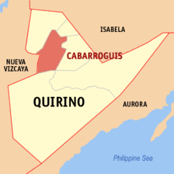 Map of Quirino with Cabarroguis highlighted | |
OpenStreetMap  | |
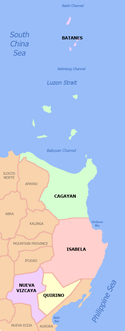
 Cabarroguis Location within the Philippines | |
| Coordinates: 16°35′00″N 121°30′00″E / 16.58333°N 121.5°ECoordinates: 16°35′00″N 121°30′00″E / 16.58333°N 121.5°E | |
| Country | Philippines |
| Region | Cagayan Valley |
| Province | Quirino |
| District | Lone district |
| Barangays | 17 (see Barangays) |
| Government | |
| • Type | Sangguniang Bayan |
| • Mayor | Willard V. Abuan |
| • Vice Mayor | Narciso C. Kitan |
| • Representative | Junie E. Cua |
| • Municipal Council | Members |
| • Electorate | 19,979 voters (2019) |
| Area | |
| • Total | 260.20 km2 (100.46 sq mi) |
| Elevation | 112 m (367 ft) |
| Highest elevation | 534 m (1,752 ft) |
| Lowest elevation | 95 m (312 ft) |
| Population (2020 census) [4] | |
| • Total | 33,533 |
| • Density | 130/km2 (330/sq mi) |
| • Households | 6,822 |
| Economy | |
| • Income class | 3rd municipal income class |
| • Poverty incidence | 10.81% (2015)[5] |
| • Revenue | ₱175,967,259.92 (2020) |
| • Assets | ₱346,254,539.38 (2020) |
| • Expenditure | ₱144,617,682.62 (2020) |
| • Liabilities | ₱83,884,517.65 (2020) |
| Service provider | |
| • Electricity | Quirino Electric Cooperative (QUIRELCO) |
| Time zone | UTC+8 (PST) |
| ZIP code | 3400 |
| PSGC | |
| IDD : area code | +63 (0)78 |
| Native languages | Ilocano Bugkalot Tagalog |
| Website | www |

Cabarroguis, officially the Municipality of Cabarroguis (Ilocano: Ili ti Cabarroguis; Tagalog: Bayan ng Cabarroguis), is a 3rd class municipality and capital of the province of Quirino, Philippines. According to the 2020 census, it has a population of 33,533 people. [4]
History[]
This section does not cite any sources. (April 2020) |
Prior to the advent of settlement, Cabarroguis was a vast forested area and formed parts of the municipalities of Saguday, Diffun and Aglipay. It was originally occupied by the Aetas who were later displaced by the Ilongot tribe because the Aetas were known to be of nomadic character. Many years later, permanent settlements were made by different civilized ethnic groups like Ilocanos, Tagalog and others in search of good fortune in this virgin land. As the population and settlement increased, regular barrios were created. These are the barrios of Zamora, Banuar, Burgos, Del Pilar, Dibibi, Eden, Villamor and five (5) more sitios of Villapeña, Villarose, Tucod, Calaocan and Dingasan at the municipality of Aglipay: barrios of San Marcos, Gundaway and portion of Mangandingay at the municipality of Diffun and the other part of Mangandingay at the municipality of Saguday. The above stated barrios of different municipalities became the territorial jurisdiction of Cabarroguis by virtue of Republic Act No. 5554 enacted by the Philippine Congress authored by then Honorable Senator Leonardo Perez on June 21, 1969. The newly created municipality of Cabarroguis was named in honor of the late Congressman of Nueva Vizcaya, Honorable Leon Cabarroguis.
Cabarroguis operated as a regular municipality after the 1971 local polls wherein Honorable Anastacio dela Pena become the first Local Chief Executive. Barangay Mangandingay also became the temporary seat of the municipal government, Years later, when Honorable Diomedes Dumayas was appointed as the town's executive, the seat of the Local Government officially transferred to Barangay Zamora where a 12 hectares lot was donated.
Geography[]
Cabarroguis is located in the northwestern part of the province of Quirino. It is bounded on the north, northwest and northeast by the municipalities of Diffun and Saguday respectively, on the east and southeast by the municipality of Aglipay, on the south by the municipalities of Maddela and Nagtipunan, and on the west by the province of Nueva Vizcaya. It is about 12 kilometres (7.5 mi) from the provincial boundary between Province of Quirino and Isabela at barangay San Antonio, Diffun, Quirino.
The municipal area of Cabarroguis covers 26,902 hectares approximately. The area is further distributed into the seventeen (17) barangays comprising the municipality including barangay Didipio which remains to be in the municipality and the province of Nueva Vizcaya and Quirino.
Barangays[]
Cabarroguis is politically subdivided into 17 barangays.
| Barangay | Land Area (has.) |
|---|---|
| Urban: | |
| Gundaway | 629.6612 |
| Zamora | 427.1250 |
| Mangandingay | 500.7266 |
| San Marcos | 667.7311 |
| Sub-total: | 2,255.2439 |
| Rural: | |
| Villarose | 843.1654 |
| Banuar | 546.6502 |
| Villamor | 865.3353 |
| Del Pilar | 550.1530 |
| Villapeña | 642.1622 |
| Burgos | 1,288.4090 |
| Eden | 1,001.8760 |
| Gomez | 491.8008 |
| Dingasan | 3,108.0650 |
| Calaocan | 677.9979 |
| Dibibi | 3,491.2367 |
| Sto. Domingo | 299.6062 |
| Tucod (including Didipio) | 10,869.8230 |
| Sub-total: | 24,646.7561 |
| Total: | 26,902 |
Climate[]
| Climate data for Cabarroguis, Quirino | |||||||||||||
|---|---|---|---|---|---|---|---|---|---|---|---|---|---|
| Month | Jan | Feb | Mar | Apr | May | Jun | Jul | Aug | Sep | Oct | Nov | Dec | Year |
| Average high °C (°F) | 25 (77) |
26 (79) |
28 (82) |
32 (90) |
31 (88) |
31 (88) |
30 (86) |
30 (86) |
30 (86) |
29 (84) |
27 (81) |
25 (77) |
29 (84) |
| Average low °C (°F) | 19 (66) |
20 (68) |
21 (70) |
22 (72) |
24 (75) |
24 (75) |
24 (75) |
24 (75) |
23 (73) |
23 (73) |
22 (72) |
20 (68) |
22 (72) |
| Average precipitation mm (inches) | 119 (4.7) |
83 (3.3) |
54 (2.1) |
37 (1.5) |
133 (5.2) |
132 (5.2) |
161 (6.3) |
163 (6.4) |
153 (6.0) |
142 (5.6) |
160 (6.3) |
224 (8.8) |
1,561 (61.4) |
| Average rainy days | 18.4 | 13.6 | 11.6 | 9.4 | 19.3 | 21.9 | 23.9 | 23.4 | 21.1 | 16.3 | 18.1 | 21.4 | 218.4 |
| Source: Meteoblue [6] | |||||||||||||
Demographics[]
|
| ||||||||||||||||||||||||||||||||||||
| Source: Philippine Statistics Authority [7] [8] [9][10] | |||||||||||||||||||||||||||||||||||||
Initially, year 1970 recorded a population of 7,835 person followed by census year 1975 which registered a total population of 12,226 that manifested a growth rate of 9.29%. Another increase of population was observed during census year 1980 which recorded 17,450 displaying a growth rate of 2.2% and for census year 1995, it manifested a 22,812 person displaying a growth rate of 2.25%. Base year of 2000 recorded a total population of 25,832 which manifested a growth rate of 2.25%. As of census year 2007, the population increased to 28,024 which manifested a growth rate of 1.21%.
Economy[]
| Poverty Incidence of Cabarroguis | |
| Source: Philippine Statistics Authority[11][12][13][14][15][16] | |
References[]
- ^ Municipality of Cabarroguis | (DILG)
- ^ "2015 Census of Population, Report No. 3 – Population, Land Area, and Population Density" (PDF). Philippine Statistics Authority. Quezon City, Philippines. August 2016. ISSN 0117-1453. Archived (PDF) from the original on May 25, 2021. Retrieved July 16, 2021.
- ^ https://www.philatlas.com/luzon/r02/quirino/cabarroguis.html.
- ^ a b Census of Population (2020). "Region II (Cagayan Valley)". Total Population by Province, City, Municipality and Barangay. PSA. Retrieved 8 July 2021.
- ^ https://psa.gov.ph/sites/default/files/City%20and%20Municipal-level%20Small%20Area%20Poverty%20Estimates_%202009%2C%202012%20and%202015_0.xlsx; publication date: 10 July 2019; publisher: Philippine Statistics Authority.
- ^ "Cabarroguis: Average Temperatures and Rainfall". Meteoblue. Retrieved 4 July 2021.
- ^ Census of Population (2015). "Region II (Cagayan Valley)". Total Population by Province, City, Municipality and Barangay. PSA. Retrieved 20 June 2016.
- ^ Census of Population and Housing (2010). "Region II (Cagayan Valley)". Total Population by Province, City, Municipality and Barangay. NSO. Retrieved 29 June 2016.
- ^ Censuses of Population (1903–2007). "Region II (Cagayan Valley)". Table 1. Population Enumerated in Various Censuses by Province/Highly Urbanized City: 1903 to 2007. NSO.
- ^ "Province of Quirino". Municipality Population Data. Local Water Utilities Administration Research Division. Retrieved 17 December 2016.
- ^ "Poverty incidence (PI):". Philippine Statistics Authority. Retrieved 28 December 2020.
- ^ https://psa.gov.ph/sites/default/files/NSCB_LocalPovertyPhilippines_0.pdf; publication date: 29 November 2005; publisher: Philippine Statistics Authority.
- ^ https://psa.gov.ph/sites/default/files/2003%20SAE%20of%20poverty%20%28Full%20Report%29_1.pdf; publication date: 23 March 2009; publisher: Philippine Statistics Authority.
- ^ https://psa.gov.ph/sites/default/files/2006%20and%202009%20City%20and%20Municipal%20Level%20Poverty%20Estimates_0_1.pdf; publication date: 3 August 2012; publisher: Philippine Statistics Authority.
- ^ https://psa.gov.ph/sites/default/files/2012%20Municipal%20and%20City%20Level%20Poverty%20Estima7tes%20Publication%20%281%29.pdf; publication date: 31 May 2016; publisher: Philippine Statistics Authority.
- ^ https://psa.gov.ph/sites/default/files/City%20and%20Municipal-level%20Small%20Area%20Poverty%20Estimates_%202009%2C%202012%20and%202015_0.xlsx; publication date: 10 July 2019; publisher: Philippine Statistics Authority.
External links[]
| Wikimedia Commons has media related to Cabarroguis. |
- Cabarroguis Profile at PhilAtlas.com
- Cabarroguis.gov.ph
- Philippine Standard Geographic Code
- Philippine Census Information
- Local Governance Performance Management System
Places adjacent to Cabarroguis | ||||||||||||||||
|---|---|---|---|---|---|---|---|---|---|---|---|---|---|---|---|---|
| ||||||||||||||||
- Municipalities of Quirino
- Provincial capitals of the Philippines