Lanao del Norte
Lanao del Norte | |
|---|---|
| Province of Lanao del Norte | |
 Flag  Seal | |
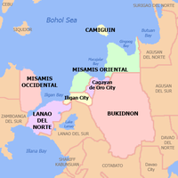
 Location in the Philippines | |
| Coordinates: 8°02′N 124°00′E / 8.03°N 124°ECoordinates: 8°02′N 124°00′E / 8.03°N 124°E | |
| Country | Philippines |
| Region | Northern Mindanao |
| Founded | May 22, 1959 |
| Capital | Tubod |
| Government | |
| • Governor | Imelda Dimaporo (PDP-LABAN) |
| • Vice Governor | Maria Cristina N. Atay (PDP-LABAN) |
| Area | |
| • Total | 3,346.57 km2 (1,292.12 sq mi) |
| Area rank | 40th out of 81 |
| (excluding Iligan) | |
| Highest elevation (Mount Inayawan) | 1,535 m (5,036 ft) |
| Population (2020 census) [2] | |
| • Total | 722,902 |
| • Rank | 43rd out of 81 |
| • Density | 220/km2 (560/sq mi) |
| • Density rank | 46th out of 81 |
| (excluding Iligan) | |
| Divisions | |
| • Independent cities | show
1 |
| • Component cities | 0 |
| • Municipalities | show
22 |
| • Barangays |
|
| • Districts | 1st and 2nd districts of Lanao del Norte |
| Time zone | UTC+8 (PHT) |
| ZIP codes | 9201–9222 |
| IDD : area code | +63 (0)63 |
| ISO 3166 code | PH-LAN |
| Spoken languages |
|
| Income classification | 2nd class |
| Website | www |

Lanao del Norte (Cebuano: Amihanang Lanao; Tagalog: Hilagang Lanao; Maranao: Pangotaraan Ranao) officially the Province of Lanao del Norte, is a province in the Philippines located in the Northern Mindanao region. Its capital is Tubod.
The province borders Lanao del Sur to the southeast, Zamboanga del Sur to the west, Illana Bay to the southwest, Iligan Bay to the north, Iligan City to the northeast, and is separated from Misamis Occidental by Panguil Bay to the northwest. According to the 2020 census, the province has a total population of 722,902 people. [2]
Situated within Lanao del Norte is the highly urbanized city of Iligan, which is governed independently from the province.
History[]
The province of Lanao existed from 1914 until 1959. In 1959, Republic Act No. 222 was passed by the Philippine Congress, partitioning Lanao into two provinces: Lanao del Norte and Lanao del Sur.[3] The new province was inaugurated on July 4, with Iligan City as its capital.
The province then consisted of the municipalities of Baloi, Kauswagan, Bacolod, Maigo, Kolambugan, Tubod, Baroy, Lala, Kapatagan, Karomatan and the following municipal districts that got converted into regular municipalities of Matungao, Pantao Ragat, Munai, Tangcal, and Nunungan.
In 1977, President Ferdinand E. Marcos signed Resolution No. 805, s. 1977 of the Sangguniang Panlalawigan (Parliamentary Bill No. 586) sponsored by Assemblyman Abdullah D. Dimaporo, into Presidential Decree 181 transferring the province's capital from Iligan City to the municipality of Tubod.
In October 1984, inaugural ceremonies were held to celebrate the occasion of the transfer of the Provincial Capitol from Poblacion, Tubod to the Don Mariano Marcos Government Center (now Governor Arsenio A. Quibranza Provincial Government Center) at Pigcarangan, in Tubod.
Despite the outbreak of the conflict of the MILF led by Abdullah Commander Bravo Goldiano Macapaar bin Sabbar and the Philippine Army in Kauswagan in March 2000, through the provincial government's effort, peace and order was restored in the province.[4][5]
In 2018, the Bangsamoro Organic Law was passed into law; this law provided for the establishment of a new Bangsamoro autonomous region to replace the Autonomous Region in Muslim Mindanao. According to this law, the six municipalities of Munai, Tagoloan, Pantar, Baloi, Tangcal, and Nunungan would be incorporated into this new region should a majority of voters in both the affected municipality and the parent province vote in favor of inclusion of the aforementioned municipalities in the proposed autonomous region in a plebiscite. The plebiscite was held the following year.[6] A majority of voters in the affected municipalities voted in favor of inclusion in the Bangsamoro Autonomous Region; however, the rest of Lanao del Norte voted strongly against,[7] and as a result, none of the six municipalities are included in the new autonomous region. The provincial government of Lanao del Norte had campaigned against the inclusion of the six municipalities into the region.[8]
Geography[]
Lanao del Norte is a rugged province that ranges from the coastal shorelines in the north to the high plateaus and mountains in the south. It has also diverse flora and fauna.[further explanation needed]
Lanao del Norte covers a total area of 3,346.57 square kilometres (1,292.12 sq mi)[9] occupying the southwestern section of the Northern Mindanao region in Mindanao. When Iligan is included for geographical purposes, the province's land area is 4,159.94 square kilometres (1,606.16 sq mi).[9] The province is bordered by Lanao del Sur to the southeast, Zamboanga del Sur to the west, Illana Bay to the southwest, Iligan Bay to the north, the city of Iligan to the northeast, and Panguil Bay to the northwest.
Administrative divisions[]
Lanao del Norte comprises 22 municipalities. The city of Iligan administers itself independently as a highly urbanized city.

- † Capital municipality
- Municipality
- ‡ Highly urbanized city (geographically within but independent from the province)
| ||||||||||||||||||||||||||||||||||||||||||||||||||||||||||||||||||||||||||||||||||||||||||||||||||||||||||||||||||||||||||||||||||||||||||||||||||||||||||||||||||||||||||||||||||||||||||||||||||||||||||||||||||||||||||||||||||||||||||||||||||||||||||||||||||||||||||||||||||||||||||||||||||||||||||||||||||||||||||||||||||||||||||||||||||||||||
Demographics[]

| Year | Pop. | ±% p.a. |
|---|---|---|
| 1903 | 8,272 | — |
| 1918 | 25,928 | +7.91% |
| 1939 | 99,427 | +6.61% |
| 1948 | 131,606 | +3.16% |
| 1960 | 270,603 | +6.19% |
| 1970 | 245,449 | −0.97% |
| 1975 | 262,456 | +1.35% |
| 1980 | 293,691 | +2.27% |
| 1990 | 387,524 | +2.81% |
| 1995 | 440,783 | +2.44% |
| 2000 | 473,062 | +1.53% |
| 2007 | 538,283 | +1.80% |
| 2010 | 607,917 | +4.53% |
| 2015 | 676,395 | +2.05% |
| 2020 | 722,902 | +1.32% |
| (excluding Iligan) Source: Philippine Statistics Authority [10] [11] [11] | ||
The population of Lanao del Norte in the 2020 census was 722,902 people, [2] with a density of 220 inhabitants per square kilometre or 570 inhabitants per square mile. When Iligan is included for geographical purposes, the province's population is 1,019,013 people, with a density of 245 inhabitants per square kilometre (630/sq mi).
The people in Lanao del Norte are a mixture of Maranaos and Cebuanos, with some Zamboangueños, Tausugs, Yakan, and Sama-Bajau. Historically, immigrants who came from the Christian provinces of Mindanao, Visayas and Luzon tended to settle in the northern part of Lanao while the Maranaos inhabited the south. There are also a minority of Higaonons settling in the hinterlands of Iligan.
The Maranao had settled in the area long before the arrival of the Spaniards in the Philippines. Like other groups, they possess their own culture which makes them quite unique. Their language, customs, traditions, religion, social system, costumes, music, and other features are factors that make Lanao peculiar and distinct from other Philippine provinces.
The main languages are Maranao and Cebuano, with the latter being the native language of majority of the citizens of the province. Aside from this, Filipino (Tagalog) and English are understood and spoken.
Religion[]
According to the Philippine Statistics Authority (PSA) report in 2015, 44.19% of the population of Lanao del Norte were adherents of Islam[14](predominantly Sunnites). Other sizeable Islamic sects are Ahmadiya, Sufism, Shia etc. Other religions include different sects of Christianity, Buddhism and other beliefs.
Economy[]
The economy in Lanao del Norte is predominantly based on agriculture and fishing. Factories are mostly based in Iligan City. Lanao del Norte is the home of Agus Power plants 4-7 that stretch from Balo-i to Iligan City. It serves major parts of power supply in Mindanao.[22][23] Tourism is also a growing economy in the province.
Politics and government[]
Salvador T. Lluch was the first Governor of Lanao del Norte. Second was Mohammad Ali Dimaporo, from January 1960 to September 1965 when Governor Dimaporo ran and won the congressional seat of the province. By operation of the law of succession, Vice Governor Arsenio A. Quibranza became the third Provincial Chief Executive of the province. By the mandate of the inhabitants, Governor Quibranza was elected Governor in 1967 and almost unanimously re-elected in 1971 and again in 1980.[24][25]
By virtue of the power and impact of the People Power Revolution on EDSA on February 25, 1986, local government all over the Philippines changed the political atmosphere overnight. Lanao del Norte became one among the many provinces affected by the sudden changes brought by the "Snap Election" in February 1986. Local heads of offices and employees particularly those holding political positions were destabilized but with the installation of President Corazon Aquino as president, OIC Atty. Francisco L. Abalos became the appointed governor of the province on March 3, 1986. On February 2, 1988, Atty. Abalos was elected as governor of the province.
In the Synchronized National Election of May 11, 1992, Congressman Abdullah D. Dimaporo, a legislator and economist, was elected Provincial Governor. The Provincial government embarked on a comprehensive planning and set the groundwork for the development of the province.
In the 1998 national and local elections, Imelda Quibranza-Dimaporo, wife of Governor Abdullah. D. Dimaporo was elected as Provincial Governor until 2007.
The eldest son of former Governor and now 2nd district representative Abdullah D. Dimaporo and incumbent Gov. Imelda Q. Dimaporo, Mohammad Khalid Q. Dimaporo enter the politics in the province since 2007 - 2016.[26]
See also[]
- Lanao
- Lanao del Sur
References[]
- ^ "List of Provinces". PSGC Interactive. Makati, Philippines: National Statistical Coordination Board. Archived from the original on 11 January 2013. Retrieved 26 June 2014.
- ^ Jump up to: a b c Census of Population (2020). "Region X (Northern Mindanao)". Total Population by Province, City, Municipality and Barangay. PSA. Retrieved 8 July 2021.
- ^ "Republic Act No. 2228 - An Act to Create the Provinces of Lanao del Norte and Lanao del Sur". Chan Robles Virtual Law Library. Retrieved 24 December 2015.
- ^ Gallardo, Froilan (November 16, 2012). "Clash between soldiers, MILF averted in Lanao del Norte". MindaNews. MindaNews. Retrieved 19 May 2019.
- ^ "2 Lanao Norte towns under attack by suspected MILF". GMA News. August 18, 2008. Retrieved 19 May 2019.
- ^ "Several North Cotabato, Lanao del Norte towns vote in second round of Bangsamoro plebiscite". CNN Philippines. CNN Philippines. Retrieved 19 May 2019.
- ^ Tomacruz, Sofia. "Lanao del Norte rejects inclusion of towns in Bangsamoro region". Rappler. Rappler. Retrieved 19 May 2019.
- ^ Luczon, Nef; Jerusalem, Jigger; Suson, Divina. "6 towns to remain in Lanao Norte after BOL plebiscite". Philippine News Agency. Philippine News Agency. Retrieved 19 May 2019.
- ^ Jump up to: a b c d "Province: Lanao del Norte". PSGC Interactive. Quezon City, Philippines: Philippine Statistics Authority. Retrieved 8 January 2016.
- ^ Jump up to: a b Census of Population (2015). "Region X (Northern Mindanao)". Total Population by Province, City, Municipality and Barangay. PSA. Retrieved 20 June 2016.
- ^ Jump up to: a b c Census of Population and Housing (2010). "Region X (Northern Mindanao)". Total Population by Province, City, Municipality and Barangay. NSO. Retrieved 29 June 2016.
- ^ Table 11. Household Population by Ethnicity and Sex: 2010 (Lanao del Norte)
- ^ Table 11. Household Population by Ethnicity and Sex: 2010 (Iligan City)
- ^ Philippine Statistics Authority (July 26, 2017). "Muslim Population in Mindanao (based on POPCEN 2015". Retrieved Aug 31, 2018.
- ^ "Poverty incidence (PI):". Philippine Statistics Authority. Retrieved 28 December 2020.
- ^ https://psa.gov.ph/sites/default/files/NSCB_LocalPovertyPhilippines_0.pdf; publication date: 29 November 2005; publisher: Philippine Statistics Authority.
- ^ https://psa.gov.ph/sites/default/files/2009%20Poverty%20Statistics.pdf; publication date: 8 February 2011; publisher: Philippine Statistics Authority.
- ^ https://psa.gov.ph/sites/default/files/Table%202.%20%20Annual%20Per%20Capita%20Poverty%20Threshold%2C%20Poverty%20Incidence%20and%20Magnitude%20of%20Poor%20Population%2C%20by%20Region%20and%20Province%20%20-%202006%2C%202009%2C%202012%20and%202015.xlsx; publication date: 27 August 2016; publisher: Philippine Statistics Authority.
- ^ https://psa.gov.ph/sites/default/files/Table%202.%20%20Annual%20Per%20Capita%20Poverty%20Threshold%2C%20Poverty%20Incidence%20and%20Magnitude%20of%20Poor%20Population%2C%20by%20Region%20and%20Province%20%20-%202006%2C%202009%2C%202012%20and%202015.xlsx; publication date: 27 August 2016; publisher: Philippine Statistics Authority.
- ^ https://psa.gov.ph/sites/default/files/Table%202.%20%20Annual%20Per%20Capita%20Poverty%20Threshold%2C%20Poverty%20Incidence%20and%20Magnitude%20of%20Poor%20Population%2C%20by%20Region%20and%20Province%20%20-%202006%2C%202009%2C%202012%20and%202015.xlsx; publication date: 27 August 2016; publisher: Philippine Statistics Authority.
- ^ https://psa.gov.ph/sites/default/files/Table%202.%20%20Updated%20Annual%20Per%20Capita%20Poverty%20Threshold%2C%20Poverty%20Incidence%20and%20Magnitude%20of%20Poor%20Population%20with%20Measures%20of%20Precision%2C%20by%20Region%20and%20Province_2015%20and%202018.xlsx; publication date: 4 June 2020; publisher: Philippine Statistics Authority.
- ^ Ellorin, Bencyrus (December 20, 2010). "Agus 6 hydroelectric power plant to be upgraded". MindaNews. MindaNews. Retrieved 19 May 2019.
- ^ "Finally, P2.6-B rehab of Mindanao's Agus power plant set". Rappler. Rappler. Retrieved 19 May 2019.
- ^ Arguillas, Carolyn (May 11, 2013). "SPECIAL REPORT: The ruling clans of Mindanao: same families in 50 years, 25 years". MindaNews. MindaNews. Retrieved 19 May 2019.
- ^ "Supreme Court G.R. No. L-17358". www.lawphil.net. The LawPhil Project - Arellano Law Foundation. Retrieved 19 May 2019.
- ^ "THE LEADERS YOU VOTED: Lanao del Norte 1987 to 2019". MindaNews. MindaNews. May 12, 2019. Retrieved 19 May 2019.
External links[]
 Media related to Lanao del Norte at Wikimedia Commons
 Geographic data related to Lanao del Norte at OpenStreetMap
- Philippine Standard Geographic Code
| show Places adjacent to Lanao del Norte |
|---|
| hide | |
|---|---|
Tubod (capital) | |
| Municipalities | |
| Highly urbanized city |
|

| show Authority control |
|---|
- Lanao del Norte
- Provinces of the Philippines
- Northern Mindanao
- States and territories established in 1959
- 1959 establishments in the Philippines