Mountain Province
Mountain Province | |
|---|---|
 Overlooking the Maligcong Rice Terraces in Bontoc | |
 Flag  Seal | |
 Location in the Philippines | |
| Coordinates: 17°05′N 121°10′E / 17.08°N 121.17°ECoordinates: 17°05′N 121°10′E / 17.08°N 121.17°E | |
| Country | Philippines |
| Region | Cordillera Administrative Region |
| Founded | 1908 |
| Capital | Bontoc |
| Government | |
| • Type | Sangguniang Panlalawigan |
| • Governor | |
| • Vice Governor | |
| • Representative | |
| Area | |
| • Total | 2,157.38 km2 (832.97 sq mi) |
| Area rank | 58th out of 81 |
| Population (2020 census) [2] | |
| • Total | 158,200 |
| • Rank | 76th out of 81 |
| • Density | 73/km2 (190/sq mi) |
| • Density rank | 75th out of 81 |
| Divisions | |
| • Independent cities | 0 |
| • Component cities | 0 |
| • Municipalities | show
10 |
| • Barangays | 144 |
| • Districts | Lone district of Mountain Province |
| Time zone | UTC+8 (PHT) |
| ZIP code | 2616–2625 |
| IDD : area code | +63 (0)74 |
| ISO 3166 code | PH-MOU |
| Spoken languages | |
| Website | mountainprovince |

Mountain Province is a landlocked province of the Philippines in the Cordillera Administrative Region in Luzon. Its capital is Bontoc.
Mountain Province was formerly referred to as Mountain in some foreign references. The name is usually shortened by locals to Mt. Province. The province was named so for being in the Cordillera Central mountain range found in the upper realms of Luzon island.
Mountain Province was also the name of the historical province that included most of the current Cordillera provinces. This old province was established by the Philippine Commission in 1908,[3][4][5] and was later split in 1966 into Mountain Province, Benguet, Kalinga-Apayao and Ifugao.[6][7][8]
The province is also known for its mummy caves, which contain naturally mummified bodies, and for its hanging coffins.[6]
History[]
Spanish period[]
The area of the Cordillera mountains proved difficult to control by the Spaniards. During the long Spanish rule, not much was done to bring the province under control. From 1566 to 1665, they sent expeditions to conquer the land but the rugged terrain and hostile indigenous population at the time were major obstacles to complete subjugation.[9] The first serious effort to subjugate them was made in 1785 when soldiers were sent from Cagayan to put down a revolt of the Kalingas. A famous Spanish explorer, Guillermo Galvez, conducted more than 40 forays to the mountainous region.[10]
Formerly called La Montañosa by the Spanish colonizers due to its mountainous terrain,[6][11] the area was subdivided into 6 comandancias politico-militar.[12]
| Comandancia | Year established | Comandancia | Year established |
|---|---|---|---|
| Benguet | 1846 | Amburayan | 1889 |
| Lepanto | 1852 | Kayapa | 1891 |
| Bontoc | 1859 | Cabugaoan | 1891 |
American period[]
On August 19, 1908, during the American rule, the Philippine Commission enacted Act No. 1876, which organized the entire area of the Cordilleras into one large province, named Mountain Province.[3][5][6][13]
The first governor was , and the town of Bontoc was made the capital. It was originally composed of the sub-provinces of Amburayan, Apayao, Benguet, Lepanto-Bontoc, Ifugao and Kalinga.[5][11]
Amburayan was later abolished in 1920 and its corresponding territories were transferred to the provinces of Ilocos Sur and La Union. Lepanto was also reduced in size and its towns were integrated into the sub-provinces of Bontoc and Benguet, and to the province of Ilocos Sur.[9][14] [15]
| Sub-province | Abolished? | Notes |
|---|---|---|
| Amburayan | Yes, in 1920 | Territories annexed to Ilocos Sur and La Union[5][15] |
| Apayao | No | |
| Benguet | No | Eastern towns annexed to Ilocos Sur and La Union in 1920[15] |
| Ifugao | No | |
| Kalinga | No | |
| Lepanto-Bontoc | Yes, in 1920 | Territories annexed to Ilocos Sur, Bontoc and Benguet[5][15] |
 The province in 1918 | 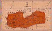 Bontoc sub-province in 1918 |
Post-war era[]
Effective on April 7, 1967, Republic Act No. 4695 abolished the old Mountain Province, converting its sub-provinces into 4 independent provinces: Benguet, Ifugao, Kalinga-Apayao and Mountain Province (corresponding to the former Bontoc sub-province).[6][8][11] On June 15, 1987, the Cordillera Administrative Region was established upon the issuance of Executive Order 220 by then-President Corazon Aquino, and Mountain Province was made one of its provinces.[9][16][17]
Geography[]

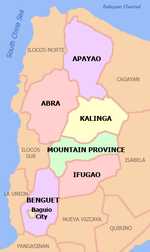
Mountain Province covers a total area of 2,157.38 square kilometres (832.97 sq mi)[18] occupying the central section of the Cordillera Administrative Region in Luzon. The province is bordered on the north by Kalinga, south by Ifugao, southwest by Benguet, west by Ilocos Sur, and northwest by Abra.
Situated within the Cordillera Central, Mountain Province is 83% mountainous while 17% make up hills and levels. The province has many rivers, waterfalls, mountains, and caves. The central and western areas of the province are characterized by rugged mountains and steep cliffs, while the eastern portion has generally sloping terrain.[6][11]
Administrative divisions[]
Mountain Province comprises ten municipalities, all encompassed by a lone legislative district.[18]

|
| |||||||||||||||||||||||||||||||||||||||||||||||||||||||||||||||||||||||||||||||||||||||||||||||||||||||||||||||||||||||||||||||||||||||||||||||||||||||||||||||||||||||||||||||||||||
Barangays[]
Mountain Province has 144 barangays comprising its 10 municipalities. [20]
As of 2010, the most populous barangay in the province is Poblacion in the municipality of Paracelis, with a total of 5,687 inhabitants. Balintaugan in the municipality of Bauko has the least population with only 144. [20]
Demographics[]
The population of Mountain Province in the 2020 census was 158,200 people, [2] with a density of 73 inhabitants per square kilometre or 190 inhabitants per square mile.
| Year | Pop. | ±% p.a. |
|---|---|---|
| 1903 | 23,441 | — |
| 1918 | 49,055 | +5.05% |
| 1939 | 59,138 | +0.89% |
| 1948 | 62,003 | +0.53% |
| 1960 | 85,866 | +2.75% |
| 1970 | 93,112 | +0.81% |
| 1975 | 94,096 | +0.21% |
| 1980 | 103,052 | +1.83% |
| 1990 | 116,535 | +1.24% |
| 1995 | 130,755 | +2.18% |
| 2000 | 140,439 | +1.54% |
| 2007 | 148,661 | +0.79% |
| 2010 | 154,187 | +1.34% |
| 2015 | 154,590 | +0.05% |
| 2020 | 158,200 | +0.45% |
| Source: Philippine Statistics Authority [19] [20] [21] | ||
Based on the 2000 census survey, Kankana-ey comprised 51.8% (72,694) of the total provincial population of 140,339. Balangao/Baliwon came in second at 13.46% (18,886), and Bontoc at 12.28% (17,234). Other ethnicities were the Ilocano at 4.97% (6,968), at 2.1% (2,947), Binontok at 1.79% (2,510), and Kalinga at 1.76% (2,468).[22]
Religion[]

Anglicanism predominates in the province with approximately 60% adherence with the other religions such as Roman Catholicism, Seventh-Day Adventist Church, Iglesia Filipina Indepiendente, Iglesia ni Cristo and Free Believers in Christ Fellowship.[citation needed]
Mountain Province is the only predominantly Protestant province in the Philippines.
Economy[]
| Poverty Incidence of Mountain Province | |
| Source: Philippine Statistics Authority[23][24][25][26][27][28][29] | |
Infrastructure[]
Electricity[]

Tourism[]
The province has several rice terraces in seven of its different towns:[11]
- Ambasing Rice Terraces — Sagada
- Bangaan Rice Terraces — Sagada
- Bangen Rice Terraces — Bauko
- Barlig Rice Terraces — Barlig
- Bayyo Rice Terraces — Bontoc
- Besao Rice Terraces — Besao
- Bontoc Poblacion Rice Terraces — Bontoc
- Bucas Rice Terraces — Besao
- Bulongan Rice Terraces — Sagada
- Dalican Rice Terraces — Bontoc
- Fidelisan Rice Terraces — Sagada
- Focong Rice Terraces — Sadanga
- Kapayawan Rice Terraces — Bauko
- Kiltepan Rice Terraces — Sagada
- Maligcong Rice Terraces — Bontoc
- Natonin Rice Terraces — Natonin
- Sadanga Rice Terraces — Sadanga
- Suyo Rice Terraces — Sagada
- Tanulong Rice Terraces — Sagada
The mountainous province also offers excellent mountain climbing experiences with two of its mountains among the top 10 highest points in the Philippines:
- Mount Kalawitan, 2,714+msl - Sabangan
- Mount Amuyao or Mount Finaroy, 2,702+msl - Barlig
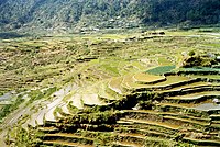
Sagada rice terraces

Rice terraces in Barlig

Government[]
List of former governors[]
- 2001–2004 — Sario M. Malinias
- 2004–2010 — Maximo B. Dalog
- 2010–2016 — Leonard G. Mayaen
- 2016–present — Bonifacio C. Lacwasan Jr.
References[]
- ^ "List of Provinces". PSGC Interactive. Makati, Philippines: National Statistical Coordination Board. Retrieved 23 December 2013.
- ^ Jump up to: a b Census of Population (2020). Highlights of the Philippine Population 2020 Census of Population. PSA. Retrieved 8 July 2021.
- ^ Jump up to: a b c Worcester, Dean C.; Philippine Commission (1908). Seventh Annual Report of the Secretary of the Interior to the Philippine Commission for the Fiscal Year Ended June 30, 1908 (Digitized by Google on 23 Nov 2005 (Original file from the University of Michigan)). Manila: U.S. Government Printing Office. pp. 17–19. Retrieved 2 January 2015.
(Google Books link)
- ^ Keesing, Felix Maxwell; Keesing, Marie Margaret; Keesing, Marie Martin; Institute of Pacific Relations (contributor); International Research Committee (contributor) (1934). Taming Philippine Headhunters: A Study of Government and of Cultural Change in Northern Luzon. Stanford University Press. p. 69. ISBN 9780804721103. Retrieved 2 January 2015.
- ^ Jump up to: a b c d e f Ingles, Raul Rafael (2008). 1908 :The Way it Really was : Historical Journal for the UP Centennial, 1908-2008. Diliman, Quezon City: University of the Philippines Press. p. 339. ISBN 9789715425803. Retrieved 22 October 2014.
- ^ Jump up to: a b c d e f Lancion, Jr., Conrado M.; de Guzman, Rey (cartography) (1995). "The Provinces". Fast Facts about Philippine Provinces (The 2000 Millenium ed.). Makati, Metro Manila: Tahanan Books. pp. 108–109. ISBN 971-630-037-9. Retrieved 16 January 2015.
- ^ "Natural Attractions found in Atok". Province of Benguet. Retrieved 13 August 2013.
- ^ Jump up to: a b "Republic Act No. 4695: An Act Creating the Provinces of Benguet, Mountain Province, Ifugao and Kalinga-Apayao". Chan Robles Virtual Law Library. Retrieved 22 October 2014.
- ^ Jump up to: a b c "Mt. Province". VisitMyPhilippines.com The Ultimate Travel Guide for Tourists. Department of Tourism. Retrieved 23 December 2013.
- ^ "Area of Coverage: The Region". ati.da.gov.ph. Retrieved 19 January 2021.
- ^ Jump up to: a b c d e "Facts & Figures: Mountain Province". Philippine Statistics Authority - National Statistical Coordination Board - Cordillera Administrative Region. Archived from the original on 1 September 2016. Retrieved 22 October 2014.
- ^ Jump up to: a b c "Benguet History". Province of Benguet (official website). Archived from the original on 19 October 2014. Retrieved 22 October 2014.
Benguet was once part of Mountain Province.
- ^ "Act No. 1876". PhilippineLaw.info. 18 August 1908. Archived from the original on 15 October 2014. Retrieved 22 October 2014.
- ^ Philippines. Census Office; Buencamino, Felipe; Villamor, Ignacio (1920). Census of the Philippine Islands Taken Under the Direction of the Philippine Legislature in the Year 1918, Volume 1. Bureau of printing. p. 68.
- ^ Jump up to: a b c d e "Cordillera Administrative Region History". Cordillera Connection (Blogspot). 14 August 2009. Retrieved 22 October 2014.
- ^ "Regional Profile: Cordillera Administrative Region (CAR)". CountrySTAT Philippines. Archived from the original on 22 October 2014. Retrieved 22 October 2014.
- ^ "The Cordillera Administrative Region (CAR)". Department of Agriculture. Retrieved 22 October 2014.
- ^ Jump up to: a b c "Province: Mountain Province". PSGC Interactive. Quezon City, Philippines: Philippine Statistics Authority. Retrieved 8 January 2016.
- ^ Jump up to: a b Census of Population (2015). Highlights of the Philippine Population 2015 Census of Population. PSA. Retrieved 20 June 2016.
- ^ Jump up to: a b c d Census of Population and Housing (2010). Population and Annual Growth Rates for The Philippines and Its Regions, Provinces, and Highly Urbanized Cities (PDF). NSO. Retrieved 29 June 2016.
- ^ Census of Population and Housing (2010). "Cordillera Administrative Region (CAR)". Total Population by Province, City, Municipality and Barangay. NSO. Retrieved 29 June 2016.
- ^ Jump up to: a b "Mountain Province – Home of the Kankanais; Table 4. Household Population by Ethnicity and Sex: Mountain Province, 2000". Philippine Statistics Authority. 6 February 2002. Archived from the original on 15 June 2002. Retrieved 27 July 2016.
- ^ "Poverty incidence (PI):". Philippine Statistics Authority. Retrieved 28 December 2020.
- ^ https://psa.gov.ph/sites/default/files/NSCB_LocalPovertyPhilippines_0.pdf; publication date: 29 November 2005; publisher: Philippine Statistics Authority.
- ^ https://psa.gov.ph/sites/default/files/2009%20Poverty%20Statistics.pdf; publication date: 8 February 2011; publisher: Philippine Statistics Authority.
- ^ https://psa.gov.ph/sites/default/files/Table%202.%20%20Annual%20Per%20Capita%20Poverty%20Threshold%2C%20Poverty%20Incidence%20and%20Magnitude%20of%20Poor%20Population%2C%20by%20Region%20and%20Province%20%20-%202006%2C%202009%2C%202012%20and%202015.xlsx; publication date: 27 August 2016; publisher: Philippine Statistics Authority.
- ^ https://psa.gov.ph/sites/default/files/Table%202.%20%20Annual%20Per%20Capita%20Poverty%20Threshold%2C%20Poverty%20Incidence%20and%20Magnitude%20of%20Poor%20Population%2C%20by%20Region%20and%20Province%20%20-%202006%2C%202009%2C%202012%20and%202015.xlsx; publication date: 27 August 2016; publisher: Philippine Statistics Authority.
- ^ https://psa.gov.ph/sites/default/files/Table%202.%20%20Annual%20Per%20Capita%20Poverty%20Threshold%2C%20Poverty%20Incidence%20and%20Magnitude%20of%20Poor%20Population%2C%20by%20Region%20and%20Province%20%20-%202006%2C%202009%2C%202012%20and%202015.xlsx; publication date: 27 August 2016; publisher: Philippine Statistics Authority.
- ^ https://psa.gov.ph/sites/default/files/Table%202.%20%20Updated%20Annual%20Per%20Capita%20Poverty%20Threshold%2C%20Poverty%20Incidence%20and%20Magnitude%20of%20Poor%20Population%20with%20Measures%20of%20Precision%2C%20by%20Region%20and%20Province_2015%20and%202018.xlsx; publication date: 4 June 2020; publisher: Philippine Statistics Authority.
External links[]
 Media related to Mountain Province at Wikimedia Commons
 Geographic data related to Mountain Province at OpenStreetMap
| show Places adjacent to Mountain Province |
|---|

| show Authority control |
|---|
- Mountain Province
- Provinces of the Philippines
- States and territories established in 1908
- 1908 establishments in the Philippines