Chico River (Philippines)
| Chico River Río Chico de Cagayán | |
|---|---|
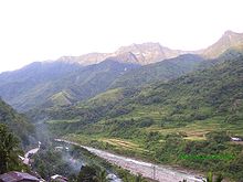
 The river along Bontoc | |
 Chico River mouth | |
| Location | |
| Country | Philippines |
| Region | |
| Province | |
| Physical characteristics | |
| Source | |
| • location | Mount Data, Cordillera mountains |
| • coordinates | 16°55′01.5″N 120°54′26.9″E / 16.917083°N 120.907472°E |
| • elevation | 2,079 m (6,821 ft) |
| Mouth | Cagayan River |
• location | Santo Niño, Cagayan, Cagayan Valley |
• coordinates | 17°57′50.5″N 121°36′36.2″E / 17.964028°N 121.610056°ECoordinates: 17°57′50.5″N 121°36′36.2″E / 17.964028°N 121.610056°E |
• elevation | 5 m (16 ft) |
| Length | 233 km (145 mi) |
| Basin size | 5,850 km2 (2,260 sq mi) |
| Discharge | |
| • location | Cagayan River |
| • average | 410 m3/s (14,000 cu ft/s) |
| Basin features | |
| Progression | Chico–Cagayan |
| Tributaries | |
| • left | |
| • right |
|


The Chico River (Spanish: Río Chico de Cagayán), is a river system in the Philippines in the island of Luzon, encompassing the regions of Cordillera and Cagayan Valley. It is the longest tributary of Cagayan River with a total length of 233 km (145 mi).
The most extensive river in the Cordillera region, it covers the provinces of Mountain Province, Kalinga and Cagayan. It is referred to as a "river of life" for the Kalinga people who live on its banks, and is well known among development workers because of the Chico River Dam Project, an electric power generation project which local residents resisted for three decades before it was finally shelved in the 1980s - a landmark case study concerning ancestral domain issues in the Philippines.[1][2]
Geography[]
The Chico River, has a total length of 233 kilometres (145 mi)[3] and the longest tributary of the Cagayan River.
Source and course[]
The highest headwaters begin along the slopes of Mount Data in the Cordillera mountains at Bauko, Mountain Province. It then flows northeastward through Bontoc, Sabangan, Sadanga, Tinglayan, Lubuagan, Tabuk City, Pinukpuk, Tuao, Piat, Rizal, and finally at Santo Niño, where it merges with the Cagayan River.
Its tributaries are the to the south, The and Biga Rivers to the east, The and to the North, and the further downstream.[4][5]
References[]
- ^ Bula-at, Leticia; See (editor/translator), Bernice (1996). "Indigenous Women's Struggles: The Chico Dam Project and the Kalinga Women". Solidarity Philippines Australia Network (SPAN). KASAMA Vol. 10 No. 2. Retrieved 11 January 2015.
- ^ Malvar, Gabby. "Where the Chico River Rumbles". Travelife Magazine. Archived from the original on 7 April 2012. Retrieved 11 January 2015.
- ^ Allad-iw, Arthur L. (6 June 2009). "Cordillera Tribes Heighten Struggle Against Large-Scale Mines in Chico River Watersheds". Northern Dispatch. Retrieved 11 January 2015.
- ^ "Dams in the Cordillera" (PDF). International Rivers. Cordillera People's Aliiance - Public Information Commission. 1 January 2001. p. 1. Archived from the original (PDF) on 4 January 2015. Retrieved 11 January 2015.
- ^ "Kalinga; The Land of Living Waters". Kalinga Provincial Government (official website). 27 December 2006. Archived from the original on 6 February 2007. Retrieved 11 January 2015.
- Rivers of the Philippines
- Landforms of Mountain Province
- Landforms of Kalinga (province)
- Landforms of Cagayan
- Asia river stubs
- Philippines geography stubs