Cagayan
This article needs additional citations for verification. (January 2014) |
Cagayan | |
|---|---|
| Province of Cagayan | |
| Nickname(s): Land of smile and beauty | |
| Motto(s): Pabaruen ti Cagayan | |
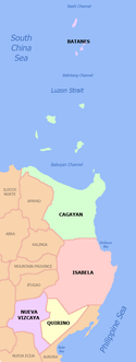
 Location in the Philippines | |
| Coordinates: 18°00′N 121°48′E / 18°N 121.8°ECoordinates: 18°00′N 121°48′E / 18°N 121.8°E | |
| Country | Philippines |
| Region | Cagayan Valley |
| Founded | June 29, 1583 |
| Capital | Tuguegarao |
| Government | |
| • Governor | Manuel N. Mamba, MD (Independent) |
| • Vice Governor | Melvin K. Vargas Jr. (UNA) |
| Area | |
| • Total | 9,295.75 km2 (3,589.11 sq mi) |
| Area rank | 5th out of 81 |
| Highest elevation () | 1,823 m (5,981 ft) |
| Population (2020 census) [2] | |
| • Total | 1,268,603 |
| • Estimate (2020) | 1,273,219[3] |
| • Rank | 22nd out of 81 |
| • Density | 140/km2 (350/sq mi) |
| • Density rank | 63rd out of 81 |
| Divisions | |
| • Independent cities | 0 |
| • Component cities | show
1 |
| • Municipalities | show
28 |
| • Barangays | 820 |
| • Districts | 1st to 3rd districts of Cagayan |
| Time zone | UTC+8 (PHT) |
| ZIP code | 3500–3528 |
| IDD : area code | +63 (0)78 |
| ISO 3166 code | PH-CAG |
| Spoken languages | |
| Website | www |


Cagayan (/kɑːɡəˈjɑːn/ kah-gə-YAHN) (Ilocano: Probinsia ti Cagayan; Ibanag: Provinsiya na Cagayan; Itawit: Provinsiya ya Cagayan; Tagalog: Lalawigan ng Cagayan) is a province in the Philippines located in the Cagayan Valley region and the northeastern tip of the Luzon. Its capital is the city of Tuguegarao. It is about 431 kilometres (268 mi) northwest of Manila, and includes the Babuyan Islands to the north. The province borders Ilocos Norte and Apayao to the west, and Kalinga and Isabela to the south.
Cagayan was one of the early provinces that existed during the Spanish colonial period. Called La Provincia de Cagayan, its borders essentially covered the entire Cagayan Valley, which included the present provinces of Isabela, Quirino, Nueva Vizcaya, Batanes and portions of Kalinga and Apayao. The former capital was Nueva Segovia, which also served as the seat of the Diocese of Nueva Segovia.[4] Today, only 9,295.75 square kilometres (3,589.11 sq mi)[1] remain of the former vastness of the province. The entire region, however, is still referred to as Cagayan Valley.
Etymology[]
A folk legend holds that the name was originally derived from the tagay, a plant that grows abundantly in the northern part of the province. The term Catagayan, "the place where the tagay grows" was shortened to Cagayan.[4] Linguists, however, hold that cagayan comes from an ancient, lost word that means "river". Variations of this word—karayan, kayan, kayayan, and kalayan—all mean river.[4][5]
History[]
Pre-colonial period[]
Cagayan has a prehistoric civilization with rich and diverse culture. According to archaeologists, the earliest man in the Philippines probably lived in Cagayan thousands of years ago. Pieces of evidence to this effect are now convincing beyond scientific doubt to consider it as an incontestable fact.[citation needed]
In the classical era, Gattaran and Lal-lo used to be the home of hunter-gatherers who specialized in hunting mollusks. These hunter-gatherers have stockpiled their leftover mollusk shells in numerous sites in Gattaran and Lal-lo, until eventually, the shells formed into the largest stock of shell-midden sites in the entire Philippines.
From available evidences, the Atta or Negrito - a short dark-skinned nomad - was the first man in Cagayan. They were later moved to the uplands by the Malays who eventually became the Ibanags, Itawes, , Gaddangs, and - the natives of Cagayan - who actually came from one ethnicity. These are the people found by the Spaniards in the different villages along the rivers all over Cagayan. The Spaniards rightly judged that these various villagers came from a single racial stock and decided to make the Ibanag language the lingua franca, both civilly and ecclesiastically for the entire people of Cagayan which they called collectively as the Cagayanes which later was transliterated to become Cagayanos.
Cagayan was a major site for the Maritime Jade Road, one of the most extensive sea-based trade networks of a single geological material in the prehistoric world, operating for 3,000 years from 2000 BCE to 1000 CE.[6][7][8][9]
Even before the Spaniards came to Cagayan, the Cagayanos have already made contact with various civilizations like the Chinese, Japanese and even Indians, as evidenced by various artifacts and even the presence of minor to moderate foreign linguistic elements in the languages of the natives.
Various other racial strains, mainly the Ilocanos, Pangasinenses, Kapampangans and Tagalogs, as well as Visayans, Moros and even foreigners like the Chinese, Indians, Arabs, Spaniards and others were further infused to the native Cagayanes to become the modern Cagayano that we know today.
Cagayan is also the site of a Wokou state when the Japanese pirate-lord Tay Fusa,[10] set up his Japanese pirate kingdom in Cagayan before it was destroyed during the 1582 Cagayan battles.
Spanish colonial period[]
In 1581, Captain Ivan Sabala arrived in Cagayan with a hundred fully equipped soldiers and their families by order of Gonzalo Ronquillo de Peñaloza, the fourth Spanish Governor-General of the Philippines. The expeditionary force was sent to explore the Cagayan Valley, to convert the natives to Catholicism, and to establish ecclesiastical missions and towns throughout the valley.
On 29 June 1583, Spanish conquistador Juan de Salcedo traced the northern coastline of Luzon and set foot on the Massi (Pamplona), Tular, and Aparri areas.
La Provincia de Cagayan[]
In 1583, through a Spanish Royal Decree, the entire northeastern portion of Luzon (specifically, all territories east of the Cordillera mountains and those north of the Caraballo mountains) including the islands in the Balintang Channel were organized into one large political unit called the . The provincia's territorial delineation encompassed the present provinces of Batanes, Isabela, Quirino, Nueva Vizcaya, including portions of Kalinga and Apayao. Its capital was Nueva Segovia (the present municipality of Lal-lo).[4]
The Spanish friars soon established mission posts in Camalaniugan and Lal-lo (Nueva Segovia), which became the seat of the Diocese established by Pope Clement VIII on August 14, 1595. The see was moved in 1758 to Vigan because of its relative distance. The Spanish influence can still be seen in the massive churches and other buildings that the Spaniards built for the spiritual and social welfare of the people.
In 1839, Nueva Vizcaya was established as a politico-military province and was separated from Cagayan. Later, Isabela was founded as a separate province on May 1, 1856, its areas carved from southern Cagayan and eastern Nueva Vizcaya territories.[4]
During the late 18th century, the New Spain government encouraged the expansion of trade and development of commodity crops. Among these was tobacco, and lands in Cagayan became the center of a vertically integrated monopoly: tobacco was grown there and shipped to Manila, where it was processed and made into cigarettes and cigars. The development of the related bureaucracy and accounting systems was done under the leadership of José de Gálvez, who as visitor-general to Mexico from 1765 to 1772 developed the monopoly there and increased revenues to the Crown. He worked in the Philippines as Minister of the Indies from 1776 to 1787, constructing a similar monopoly there under Governor-General Basco y Vargas (1778–1787).[11] The Spanish development of this industry affected all their economic gains in the Philippines.[11]
The establishment of the civil government of Cagayan through the 1583 Spanish Royal Decree is commemorated in the annual celebrations of the Provincial Government of Cagayan and its people.

American period[]
When the Treaty of Paris was signed in 1898, ending the Spanish–American War, the United States took over the Philippines. It influenced the culture, most notably in agriculture and education, as well as in public works and communications. A naval base also increased interaction between local Filipinos and American sailors and administrators. At the close of the 18th century, there were 29 municipalities in the province of Cagayan. After the Philippines came under American sovereignty in 1902, more municipalities were founded. Since then, due to centralization and shifting of populations, the number of municipalities is back to 29.
World War II[]
This section needs expansion. You can help by . (November 2015) |
During the Second World War, with air raids by Japanese fighters and bombers, the province of Cagayan suffered much destruction by bombing and later invasion. Japanese Imperial forces entered Cagayan in 1942. While under the Japanese Occupation, several pre-war infantry divisions and regular units of the Philippine Commonwealth Army were re-established during the period on January 3, 1942, to June 30, 1946. They established general headquarters, camps and garrisoned troops in the province of Cagayan, and began operations against the Japanese Occupation forces in the Cagayan Valley. This included sending troops to the provinces of Cagayan and Isabela, and helping the local soldiers of the and of the USAFIP-NL, the local guerrilla fighters and the U.S. liberation forces. They fought against the Japanese Imperial forces from 1942 to 1945.
The Battle off Cape Engaño on October 26, 1944, was held off Cape Engaño. At that time American carrier forces attacked the Japanese Northern Force. This became the concluding action of the Battle of Leyte Gulf. The Japanese lost 4 carriers, 3 light cruisers and 9 destroyers.
In 1945, the combined United States and Philippine Commonwealth ground troops, together with the recognized guerrillas, took Cagayan. Part of the action were the Filipino soldiers of the , , , , and of the Philippine Commonwealth Army, 1st Constabulary Regiment of the Philippine Constabulary and the 11th and 14th Infantry Regiment of the United States Armed Forces in the Philippines – Northern Luzon or USAFIP-NL from the during the Second World War.[further explanation needed]

Post-war era[]
In 1990, the Hotel Delfino in Tuguegarao was the scene of a bloody siege related to an earlier coup attempt against President Corazon Aquino. The siege took place on March 4, when a private army with estimated at 300 men[12] seized the hotel under the command of former Cagayan governor Rodolfo Aguinaldo. He had been suspended as governor in January 1990 based on a radio announcement he made pledging to send tanks and troops to support rebel forces in Manila led by Lt. Col. Gregorio Honasan in the Dec. 1–9, 1989 coup attempt against Aquino.[13] In the week before the siege Aguinaldo was indicted on charges of rebellion and murder due to his support for that failed coup effort.
Two years earlier, after Col. Honasan led a coup attempt on August 28, 1987 that also failed, Aguinaldo—then a lieutenant colonel in Cagayan's provincial military forces—bluntly stated another coup attempt would follow if President Aquino did "not make reforms fast".[14] Aguinaldo resigned from the military to run for Cagayan governor in 1988, he won that post in a landslide.[15] Though harshly criticized for human rights abuses while serving in the regime of Ferdinand Marcos, Aguinaldo gained renown and popularity beyond Cagayan for his ardent fight against communist insurgents.[16]
Disputing his suspension as Cagayan governor and the rebellion charges, Aguinaldo refused to surrender to authorities. Along with hundreds of loyal armed followers he hid in his hometown of Gattaran. On learning government troops planned to attack his hideout, Aguinaldo proceeded with his troops toward Tuguegarao.[17] President Aquino sent Brig. Gen. Oscar Florendo, then armed forces chief of Civil Military Relations, to Tuguegarao to serve Aguinaldo with an arrest warrant.[17] After Aguinaldo's men seized control of Hotel Delfino where the general was staying, Florendo was taken hostage along with more than 50 other hotel guests. Florendo was shot at close range in the hotel and later died of his wounds.[14] Hours of standoff ensued between the two sides until nearly 1,000 government troops[14] launched an attack to dislodge Aguinaldo's forces from the hotel; government forces prevailed after more than 100 of Aguinaldo's men surrendered and about 90 were captured.[13] During this siege at least a dozen others were killed in or around the hotel; scores of civilian supporters of Aguinaldo were arrested; and a truck with assault rifles, mortars, and crates of ammunition was captured.[15] Following this melee, Aguinaldo fled with about 90 fighters for mountains in the north.[14]
Geography[]

Situated within the Cagayan Valley region, the province is bounded by the Philippine Sea on the east; on the south by Isabela province; on the west by the Cordillera Mountains; and on the north by the Balintang Channel and the Babuyan Group of Islands. About 2 kilometres (1.2 mi) from the northeastern tip of the province is the island of Palaui; a few kilometers to the west is Fuga Island. The Babuyan Group of Islands, which includes Calayan, Dalupiri, Camiguin, and Babuyan Claro, is about 60 nautical miles (110 km) north of Luzon mainland.
The eastern coast forms the northern portion of the Sierra Madre mountain range, while the western limits are generally hilly to low in elevation. The central area, dominated by a large valley, forms the lower basin of the country's longest river, the Cagayan.[4] The mouth is located at the northern town of Aparri.
The province of Cagayan comprises an aggregate land area of 9,295.75 square kilometres (3,589.11 sq mi)[18] which constitutes approximately three percent of the total land area of the country, making it the second largest province in the region.
Administrative divisions[]
Cagayan comprises 28 municipalities and one city divided into three congressional districts. It has 820 barangays. Tuguegarao City (as of December 18, 1999) is the provincial capital, regional seat, and center of business, trade, and education and the only city in the province.
- † Provincial capital and component city
- Municipality
| ||||||||||||||||||||||||||||||||||||||||||||||||||||||||||||||||||||||||||||||||||||||||||||||||||||||||||||||||||||||||||||||||||||||||||||||||||||||||||||||||||||||||||||||||||||||||||||||||||||||||||||||||||||||||||||||||||||||||||||||||||||||||||||||||||||||||||||||||||||||||||||||||||||||||||||||||||||||||||||||||||||||||||||||||||||||||||||||||||||||||||||||||||||||||||||||||||||||||||||||||||||||||||||||||||||||
Barangays[]
The 28 municipalities and 1 city of the province comprise a total of 820 barangays, with Ugac Sur in Tuguegarao City as the most populous in 2010, and Centro 15 (Poblacion) in Aparri as the least. If cities are excluded, Maura in Aparri has the highest population. [20]
Climate[]
Cagayan has a tropical savannah climate (Aw) with hot days and warm nights that last year round.
| hideClimate data for Cagayan | |||||||||||||
|---|---|---|---|---|---|---|---|---|---|---|---|---|---|
| Month | Jan | Feb | Mar | Apr | May | Jun | Jul | Aug | Sep | Oct | Nov | Dec | Year |
| Average high °C (°F) | 27.9 (82.2) |
29.1 (84.4) |
30.9 (87.6) |
32.7 (90.9) |
33.2 (91.8) |
33.8 (92.8) |
33.5 (92.3) |
33.1 (91.6) |
32.6 (90.7) |
31.8 (89.2) |
30.4 (86.7) |
28.3 (82.9) |
31.4 (88.6) |
| Average low °C (°F) | 20.6 (69.1) |
21.8 (71.2) |
22.3 (72.1) |
23.8 (74.8) |
24.7 (76.5) |
24.8 (76.6) |
24.9 (76.8) |
24.6 (76.3) |
24.2 (75.6) |
23.9 (75.0) |
22.8 (73.0) |
21.5 (70.7) |
23.3 (74.0) |
| Average rainy days | 8 | 4 | 3 | 2 | 6 | 6 | 7 | 8 | 10 | 9 | 11 | 11 | 85 |
| Source: Storm247[21] | |||||||||||||
Demographics[]
| Year | Pop. | ±% p.a. |
|---|---|---|
| 1903 | 147,946 | — |
| 1918 | 191,320 | +1.73% |
| 1939 | 292,270 | +2.04% |
| 1948 | 311,088 | +0.70% |
| 1960 | 445,289 | +3.03% |
| 1970 | 581,237 | +2.70% |
| 1975 | 644,075 | +2.08% |
| 1980 | 711,476 | +2.01% |
| 1990 | 829,867 | +1.55% |
| 1995 | 895,050 | +1.43% |
| 2000 | 993,580 | +2.26% |
| 2007 | 1,072,571 | +1.06% |
| 2010 | 1,124,773 | +1.74% |
| 2015 | 1,199,320 | +1.23% |
| 2020 | 1,268,603 | +1.11% |
| Source: Philippine Statistics Authority [19] [20] [20] | ||
The population of Cagayan in the 2020 census was 1,268,603 people, [2] with a density of 140 inhabitants per square kilometre or 360 inhabitants per square mile.
The majority of people living in Cagayan are of Ilocano descent, mostly from migrants coming from the Ilocos Region. Originally, the more numerous group were the Ibanags, who were first sighted by the Spanish explorers and converted to Christianity by missionaries, the reason why the Ibanag language had spread throughout the valley region prior to the arrival of the migrating Ilocanos. Cagayan is predominantly Roman Catholic with 85%[citation needed] of the population affiliated and the Aglipayan Church has a very strong minority in the province.
Aside from Ilocanos and Ibanags, Malawegs, Itawits, Gaddangs, groups of nomadic Aetas, as well as families of Ibatans who have assimilated into the Ibanag-Ilocano culture make Cagayan their home. More recently,[when?] a new group from the south, the Muslim Filipinos, have migrated to this province and have made a community for themselves. In addition to this, Tagalog-speaking peoples from Central Luzon and Southern Luzon have also settled in the area, as well as a few Pangasinans and Kapampangans from the central plains.
Major languages spoken are Ilocano followed by Ibanag, Yogad and Gaddang. Ilocanos and Ibanags speak Ilocano with an Ibanag accent, as descendants of Ilocanos from first generation in Cagayan who lived within Ibanag population learned Ibanag; same situation with Ilocano tinged by Gaddang, Paranan, Yogad, and Itawis accents when descendants of Ilocanos from first generation in Isabela who lived within Gaddang, , , and Itawis populations learned their languages. People especially in the capital and commercial centers speak and understand English and Tagalog/Filipino. Tagalogs, Ilocanos, and Ibanags speak Tagalog with an Ibanag accent, as descendants of Tagalogs from first generation in Isabela who lived within Ibanag population learned Ibanag.
Endangered Languages[]
There are two endangered indigenous languages in Cagayan. These are the Dupaninan Agta language (with less than 1400 remaining speakers) and the Central Cagayan Agta (with less than 799 remaining speakers) language. Both of which are listed as Vulnerable according to the UNESCO Atlas of the World's Endangered Languages. All remaining speakers of the language are part of the community's elders. Without a municipality-wide teaching mechanism of the two endangered languages for the youth where the languages are present, the language may be extinct within 3-5 decades, making them languages in grave peril unless a teaching-mechanism is established by either the government or an educational institution in the municipalities of Gattaran, Cagayan and Baggao, Cagayan.[23]
Economy[]
Agricultural products are rice, corn, peanut, beans, and fruits. Livestock products include cattle, hogs, carabaos, and poultry. Fishing various species of fish from the coastal towns is also undertaken. Woodcraft furniture made of hardwood, rattan, bamboo, and other indigenous materials are also available in the province.[4]

The Northern Cagayan International Airport is a planned airport in Lal-lo. The airport will be built to support the Cagayan Special Economic Zone in northern Cagayan, which also serves seaborne traffic through Port Irene. The airport project will involve the construction of a 2,200-meter runway, with a width of 45 meters, following the standards of the International Civil Aviation Organization. Once completed, the planned international airport can accommodate large aircraft such as the Airbus A319-100 and Boeing regional jets of comparable size.[31]
Tourism[]
Since Cagayan faces the Philippine Sea, an extensive shoreline sprawls along the northern coastal towns of Sanchez Mira, Pamplona, Santa Praxedes, Claveria, Buguey, Aparri, Ballesteros, Abulug, and the islands of Palaui, Fuga, and island municipality of Calayan. Sanchez Mira, Claveria, and Santa Praxedes have facilities for excursion stays while Fuga Island is being developed as a world-class recreation and tourism center. Activities include whale watching at the Calayan Islands, and scuba diving, snorkeling and fishing in Palaui Island of Santa Ana. The airstrip at Claveria could be used as a jump-off point to Fuga Island.
The is celebrated throughout the province in commemoration of its founding. Hotels include the Governors Garden Hotel, Hotel Candice, Hotel Roma and Hotel Kimikarlai all in Tuguegarao City.
Claveria is host to several scenic attractions which include: the Lakay-Lakay Lagoon, the rocky formation along the Camalaggaon Caves, the Roadside Park overlooking the Claveria Bay, Macatel Falls with its clear waters that run in abundance throughout the year, the Pata Lighthouse, and the Claveria Beach Resort along the white sand coasts.[32]
Notable people[]
- Paco Román - Filipino-Spanish soldier and later became a revolutionary during Philippine Revolution and Philippine–American War. Roman had the rank of a colonel in the revolutionary army, and served as the close aide of General Antonio Luna.
- Cesar Adib Majul - Philippine historian[33] best known for his work on the history of Islam in the Philippines[34] and on the life of Apolinario Mabini.[35]
- Salvador Lazo Lazo - Filipino prelate of the Roman Catholic Church. He served as Bishop of San Fernando de La Union from 1981 to 1993.[36]
- Ricardo Baccay - third Bishop of the Diocese of Alaminos, Pangasinan and former Auxiliary Bishop of the Archdiocese of Tuguegarao. Born in Tuguegarao.
- Eulogio Balao - former Secretary of the Department of National Defense and former Senator of the Republic of the Philippines, from Tuguegarao City.
- Diosdado P. Banatao - entrepreneur and engineer working in the high-tech industry.
- Lilia Cuntapay - An actress, also known as the "Queen of Philippine Horror Films", from Gonzaga, Cagayan.
- Maja Ross Andres Salvador - a popular actress of ABS-CBN, born and raised in barangay Canayun, Abulug, Cagayan.
- Silvestre Bello III - secretary of the Department of Labor and Employment from Gattaran, Cagayan.
- Arthur Tugade - secretary of the Department of Transportation from Claveria, Cagayan.
- Juan Ponce Enrile - Justice Secretary and then Defense Minister under the Marcos dictatorship and President of the Senate of the Philippines from November 2008 to June 2013, until he was arrested due to his involvement in the pork barrel scandal.
See also[]
- Callao Man
- Our Lady of Piat
- Malaueg Church
- Roman Catholic Archdiocese of Tuguegarao
- Lal-lo and Gattaran Shell Middens
References[]
- ^ Jump up to: a b "List of Provinces". PSGC Interactive. Makati, Philippines: National Statistical Coordination Board. Archived from the original on 11 January 2013. Retrieved 20 January 2014.
- ^ Jump up to: a b Census of Population (2020). "Region II (Cagayan Valley)". Total Population by Province, City, Municipality and Barangay. PSA. Retrieved 8 July 2021.
- ^ "POPULATION PROJECTIONS BY REGION, PROVINCE, CITIES AND MUNICIPALITIES, 2020-2025". www.doh.gov.ph. Department of Health. August 27, 2020. Retrieved October 16, 2020.
- ^ Jump up to: a b c d e f g Lancion, Jr., Conrado M.; de Guzman, Rey (cartography) (1995). "The Provinces". Fast Facts about Philippine Provinces (The 2000 Millenium ed.). Makati, Metro Manila: Tahanan Books. pp. 48, 49, 84, 118. ISBN 971-630-037-9. Retrieved 16 January 2015.
- ^ Reid, Lawrence; Elizaga, Elson. "The Meaning of 'Cagayan'". elson.elizaga.net. Retrieved 20 March 2021.
- ^ Tsang, Cheng-hwa (2000), "Recent advances in the Iron Age archaeology of Taiwan", Bulletin of the Indo-Pacific Prehistory Association, 20: 153–158, doi:10.7152/bippa.v20i0.11751
- ^ Turton, M. (2021). Notes from central Taiwan: Our brother to the south. Taiwan’s relations with the Philippines date back millenia, so it’s a mystery that it’s not the jewel in the crown of the New Southbound Policy. Taiwan Times.
- ^ Everington, K. (2017). Birthplace of Austronesians is Taiwan, capital was Taitung: Scholar. Taiwan News.
- ^ Bellwood, P., H. Hung, H., Lizuka, Y. (2011). Taiwan Jade in the Philippines: 3,000 Years of Trade and Long-distance Interaction. Semantic Scholar.
- ^ Barreveld, Dirk J. (April 3, 2001). The Dutch Discovery of Japan: The True Story Behind James Clavell's Famous Novel Shogun. iUniverse. ISBN 9780595192618 – via Google Books.
- ^ Jump up to: a b Jane Baxter, Chris Poullaos, Practices, Profession and Pedagogy in Accounting: Essays in Honour of Bill Birkett, Sydney University Press, 2009, pp.152-161
- ^ Yabes, Criselda (1990-03-05). "MANILA ENDS HOSTAGE STANDOFF". Washington Post. ISSN 0190-8286. Retrieved 2020-08-24.
- ^ Jump up to: a b "Government troops beat back rebel attack". UPI. Retrieved 2020-08-23.
- ^ Jump up to: a b c d Tribune, Steve Le Vine, Special to The. "PHILIPPINE RENEGADE OFFICER SAYS U.S. SHOULD 'LET US STRUGGLE'". chicagotribune.com. Retrieved 2020-08-23.
- ^ Jump up to: a b "Rebel Clash Puts Aquino in New Crisis : Philippines: The battle leaves a dozen dead, including a general. The renegade governor who supported December coup attempt escapes arrest". Los Angeles Times. 1990-03-05. Retrieved 2020-08-24.
- ^ "Col. Rodolfo Aguinaldo". FLIPZI's. Retrieved 2020-08-24.
- ^ Jump up to: a b Times, Special to The New York (1990-03-05). "14 Die as Philippine Troops Fight Rebel Governor". The New York Times. ISSN 0362-4331. Retrieved 2020-08-24.
- ^ Jump up to: a b c "Province: Cagayan". PSGC Interactive. Quezon City, Philippines: Philippine Statistics Authority. Retrieved 8 January 2016.
- ^ Jump up to: a b Census of Population (2015). "Region II (Cagayan Valley)". Total Population by Province, City, Municipality and Barangay. PSA. Retrieved 20 June 2016.
- ^ Jump up to: a b c d Census of Population and Housing (2010). "Region II (Cagayan Valley)". Total Population by Province, City, Municipality and Barangay. NSO. Retrieved 29 June 2016.
- ^ "Weather forecast for Province of Cagayan, Philippines". Storm247. Retrieved 31 January 2016.
- ^ "Table 4. Household Population by Ethnicity and Sex: Cagayan, 2000". Archived from the original on 2016-03-05. Retrieved 2017-12-07.
- ^ "UNESCO Atlas of the World's Languages in danger". www.unesco.org.
- ^ "Poverty incidence (PI):". Philippine Statistics Authority. Retrieved 28 December 2020.
- ^ https://psa.gov.ph/sites/default/files/NSCB_LocalPovertyPhilippines_0.pdf; publication date: 29 November 2005; publisher: Philippine Statistics Authority.
- ^ https://psa.gov.ph/sites/default/files/2009%20Poverty%20Statistics.pdf; publication date: 8 February 2011; publisher: Philippine Statistics Authority.
- ^ https://psa.gov.ph/sites/default/files/Table%202.%20%20Annual%20Per%20Capita%20Poverty%20Threshold%2C%20Poverty%20Incidence%20and%20Magnitude%20of%20Poor%20Population%2C%20by%20Region%20and%20Province%20%20-%202006%2C%202009%2C%202012%20and%202015.xlsx; publication date: 27 August 2016; publisher: Philippine Statistics Authority.
- ^ https://psa.gov.ph/sites/default/files/Table%202.%20%20Annual%20Per%20Capita%20Poverty%20Threshold%2C%20Poverty%20Incidence%20and%20Magnitude%20of%20Poor%20Population%2C%20by%20Region%20and%20Province%20%20-%202006%2C%202009%2C%202012%20and%202015.xlsx; publication date: 27 August 2016; publisher: Philippine Statistics Authority.
- ^ https://psa.gov.ph/sites/default/files/Table%202.%20%20Annual%20Per%20Capita%20Poverty%20Threshold%2C%20Poverty%20Incidence%20and%20Magnitude%20of%20Poor%20Population%2C%20by%20Region%20and%20Province%20%20-%202006%2C%202009%2C%202012%20and%202015.xlsx; publication date: 27 August 2016; publisher: Philippine Statistics Authority.
- ^ https://psa.gov.ph/sites/default/files/Table%202.%20%20Updated%20Annual%20Per%20Capita%20Poverty%20Threshold%2C%20Poverty%20Incidence%20and%20Magnitude%20of%20Poor%20Population%20with%20Measures%20of%20Precision%2C%20by%20Region%20and%20Province_2015%20and%202018.xlsx; publication date: 4 June 2020; publisher: Philippine Statistics Authority.
- ^ Business Mirror: 1B Airport in Cagayan "Archived copy". Archived from the original on 2012-01-10. Retrieved 2011-11-23.CS1 maint: archived copy as title (link) Retrieved November 23, 2011.
- ^ Paraiso Philippines: Cagayan, retrieved November 23, 2011.
- ^ Wadi, Julkipli (2010). Tadem, Eduardo C. (ed.). "Introduction - Islam and Philippine Society: The Writings of Cesar Adib Majul" (PDF). Asian Studies. Quezon City, Philippines: Asian Center, University of the Philippines Diliman. 46 (1–2). ISSN 0004-4679.
- ^ Schumacher, John N. (2008). "Muslims in the Philippines (Review)". Missing or empty
|url=(help) - ^ Veneracion, Jaime B. (2013-02-06). "Remembering Cesar Adib Majul and Teodoro Agoncillo (University of the Philippines System Website)". web-old.up.edu.ph. Archived from the original on 2017-09-12. Retrieved 2017-09-12.
- ^ Salvador Lazo Lazo
External links[]
 Cagayan travel guide from Wikivoyage
 Media related to Cagayan (province) at Wikimedia Commons
 Geographic data related to Cagayan at OpenStreetMap
- Official Website of the Provincial Government of Cagayan
| show Places adjacent to Cagayan |
|---|
| hide | |
|---|---|
Tuguegarao (capital) | |
| Municipalities |
|
| Component city |
|
| Barangays | |

| show Authority control |
|---|
- Cagayan
- Provinces of the Philippines
- States and territories established in 1583
- 1583 establishments in the Philippines