Tangub
Tangub
Regidor | |
|---|---|
Component city | |
| City of Tangub | |
 Seal | |
| Nickname(s): Christmas Symbols Capital of the Philippines | |
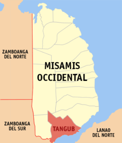 Map of Misamis Occidental with Tangub highlighted | |
show OpenStreetMap | |
 Tangub Location within the Philippines | |
| Coordinates: 8°04′00″N 123°45′00″E / 8.06666667°N 123.75°ECoordinates: 8°04′00″N 123°45′00″E / 8.06666667°N 123.75°E | |
| Country | Philippines |
| Region | Northern Mindanao |
| Province | Misamis Occidental |
| District | 2nd district |
| Cityhood | June 17, 1967 |
| Barangays | 55 (see Barangays) |
| Government | |
| • Type | Sangguniang Panlungsod |
| • Mayor | Jennifer W. Tan |
| • Vice Mayor | Alberto C. Peñas |
| • Representative | Henry S. Oaminal |
| • City Council | show
Members |
| • Electorate | 40,080 voters (2019) |
| Area | |
| • Total | 162.78 km2 (62.85 sq mi) |
| Elevation | 243 m (797 ft) |
| Highest elevation | 2,421 m (7,943 ft) |
| Lowest elevation | 0 m (0 ft) |
| Population (2020 census) [3] | |
| • Total | 68,389 |
| • Density | 420/km2 (1,100/sq mi) |
| • Households | 12,868 |
| Economy | |
| • Income class | 4th city income class |
| • Poverty incidence | 35.47% (2015)[4] |
| • Revenue | ₱406,825,376.70 (2016) |
| Service provider | |
| • Electricity | Misamis Occidental 2 Electric Cooperative (MOELCI 2) |
| Time zone | UTC+8 (PST) |
| ZIP code | 7214 |
| PSGC | |
| IDD : area code | +63 (0)88 |
| Climate type | tropical climate |
| Native languages | Subanon Cebuano Tagalog |
| Website | tangubcity |


Tangub, officially the City of Tangub (Cebuano: Dakbayan sa Tangub; Tagalog: Lungsod ng Tangub), is a 4th class component city in the province of Misamis Occidental, Philippines. According to the 2020 census, it has a population of 68,389 people. [3]
The city was formerly called Regidor until 1930 when it was given its current name.[5]
Geography[]
Tangub is located on the northern shores of Panguil Bay.
Climate[]
| hideClimate data for Tangub City, Misamis Occidental | |||||||||||||
|---|---|---|---|---|---|---|---|---|---|---|---|---|---|
| Month | Jan | Feb | Mar | Apr | May | Jun | Jul | Aug | Sep | Oct | Nov | Dec | Year |
| Average high °C (°F) | 29 (84) |
30 (86) |
31 (88) |
31 (88) |
30 (86) |
30 (86) |
29 (84) |
30 (86) |
30 (86) |
30 (86) |
30 (86) |
30 (86) |
30 (86) |
| Average low °C (°F) | 22 (72) |
22 (72) |
22 (72) |
23 (73) |
24 (75) |
24 (75) |
24 (75) |
24 (75) |
24 (75) |
24 (75) |
23 (73) |
23 (73) |
23 (74) |
| Average precipitation mm (inches) | 69 (2.7) |
58 (2.3) |
67 (2.6) |
60 (2.4) |
109 (4.3) |
114 (4.5) |
83 (3.3) |
78 (3.1) |
76 (3.0) |
92 (3.6) |
86 (3.4) |
63 (2.5) |
955 (37.7) |
| Average rainy days | 12.8 | 11.6 | 14.8 | 17.4 | 24.8 | 23.5 | 20.7 | 18.5 | 17.4 | 22.5 | 21.6 | 15.6 | 221.2 |
| Source: Meteoblue [6] | |||||||||||||
Barangays[]
Tangub is politically subdivided into 55 barangays.
- Silanga
- Aquino (Marcos)
- Santa Maria (Baga)
- Balatacan
- Baluk
- Banglay
- Mantic
- Mingcanaway
- Bintana
- Bocator
- Bongabong
- Caniangan
- Capalaran
- Catagan
- Barangay I - City Hall (Poblacion)
- Barangay II - Marilou Annex (Poblacion)
- Barangay IV - St. Michael (Poblacion)
- Isidro D. Tan (Dimalooc)
- Garang
- Guinabot
- Guinalaban
- Hoyohoy
- Kauswagan
- Kimat
- Labuyo
- Lorenzo Tan
- Barangay VI - Lower Polao (Poblacion)
- Lumban
- Maloro
- Barangay V - Malubog (Poblacion)
- Manga
- Maquilao
- Barangay III- Market Kalubian (Pob.
- Matugnao
- Minsubong
- Owayan
- Paiton
- Panalsalan
- Pangabuan
- Prenza
- Salimpuno
- San Antonio
- San Apolinario
- San Vicente
- Santa Cruz
- Santo Niño
- Sicot
- Silanga
- Silangit
- Simasay
- Sumirap
- Taguite
- Tituron
- Tugas
- Barangay VII - Upper Polao (Poblacion)
- Villaba
Demographics[]
| Year | Pop. | ±% p.a. |
|---|---|---|
| 1939 | 44,743 | — |
| 1948 | 20,353 | −8.38% |
| 1960 | 21,101 | +0.30% |
| 1970 | 30,918 | +3.89% |
| 1975 | 40,461 | +5.54% |
| 1980 | 40,401 | −0.03% |
| 1990 | 42,926 | +0.61% |
| 1995 | 46,004 | +1.31% |
| 2000 | 49,695 | +1.67% |
| 2007 | 56,644 | +1.82% |
| 2010 | 59,892 | +2.05% |
| 2015 | 63,011 | +0.97% |
| 2020 | 68,389 | +1.62% |
| Source: Philippine Statistics Authority [7] [8] [9][10] | ||
In the 2020 census, the population of Tangub was 68,389 people, [3] with a density of 420 inhabitants per square kilometre or 1,100 inhabitants per square mile.
Economy[]
| Poverty Incidence of Tangub | |
| Source: Philippine Statistics Authority[11][12][13][14][15][16] | |
Festivals[]
Tangub, through its Sinanduloy Cultural Troupe, is a regular participant of the Sinulog Festival, a festival held in Cebu City. This festival is the pageantry of sights, sounds and colors as it honors and pays homage to the patron saint of Cebu, Sr. Santo Niño, the child Jesus. The highlights of the festival is from January 9–18, yearly. Tangub City has won a record of twelve grand champion streak in the Sinulog-Based Category of the festival.
Through the recent years, Tangub has been popularly dubbed as the Christmas Symbols Capital of the Philippines.
Tangub City has its own festival - Dalit Festival. It is in honor of the city's patron saint, Saint Michael the Archangel. It is celebrated every 29 September-the feast day of St. Michael. It is participated by the city's baranggays through clusters represented by local schools.
Sister cities of Tangub[]
See also[]
References[]
- ^ City of Tangub | (DILG)
- ^ "2015 Census of Population, Report No. 3 – Population, Land Area, and Population Density" (PDF). Philippine Statistics Authority. Quezon City, Philippines. August 2016. ISSN 0117-1453. Archived (PDF) from the original on May 25, 2021. Retrieved July 16, 2021.
- ^ Jump up to: a b c Census of Population (2020). "Region X (Northern Mindanao)". Total Population by Province, City, Municipality and Barangay. PSA. Retrieved 8 July 2021.
- ^ https://psa.gov.ph/sites/default/files/City%20and%20Municipal-level%20Small%20Area%20Poverty%20Estimates_%202009%2C%202012%20and%202015_0.xlsx; publication date: 10 July 2019; publisher: Philippine Statistics Authority.
- ^ History and Heritage, City Government of Tangub, retrieved 2012
- ^ "Tangub: Average Temperatures and Rainfall". Meteoblue. Retrieved 29 April 2020.
- ^ Census of Population (2015). "Region X (Northern Mindanao)". Total Population by Province, City, Municipality and Barangay. PSA. Retrieved 20 June 2016.
- ^ Census of Population and Housing (2010). "Region X (Northern Mindanao)". Total Population by Province, City, Municipality and Barangay. NSO. Retrieved 29 June 2016.
- ^ Censuses of Population (1903–2007). "Region X (Northern Mindanao)". Table 1. Population Enumerated in Various Censuses by Province/Highly Urbanized City: 1903 to 2007. NSO.
- ^ "Province of Misamis Occidental". Municipality Population Data. Local Water Utilities Administration Research Division. Retrieved 17 December 2016.
- ^ "Poverty incidence (PI):". Philippine Statistics Authority. Retrieved 28 December 2020.
- ^ https://psa.gov.ph/sites/default/files/NSCB_LocalPovertyPhilippines_0.pdf; publication date: 29 November 2005; publisher: Philippine Statistics Authority.
- ^ https://psa.gov.ph/sites/default/files/2003%20SAE%20of%20poverty%20%28Full%20Report%29_1.pdf; publication date: 23 March 2009; publisher: Philippine Statistics Authority.
- ^ https://psa.gov.ph/sites/default/files/2006%20and%202009%20City%20and%20Municipal%20Level%20Poverty%20Estimates_0_1.pdf; publication date: 3 August 2012; publisher: Philippine Statistics Authority.
- ^ https://psa.gov.ph/sites/default/files/2012%20Municipal%20and%20City%20Level%20Poverty%20Estima7tes%20Publication%20%281%29.pdf; publication date: 31 May 2016; publisher: Philippine Statistics Authority.
- ^ https://psa.gov.ph/sites/default/files/City%20and%20Municipal-level%20Small%20Area%20Poverty%20Estimates_%202009%2C%202012%20and%202015_0.xlsx; publication date: 10 July 2019; publisher: Philippine Statistics Authority.
External links[]
| Wikivoyage has a travel guide for Tangub. |
- Philippine Standard Geographic Code
- Philippine Census Information
- Local Governance Performance Management System
| show Places adjacent to Tangub |
|---|
| show Articles Related to Tangub |
|---|
| show Authority control |
|---|
- Cities in Misamis Occidental
- Populated places established in 1930
- 1930 establishments in the Philippines
- Misamis Occidental
- Component cities in the Philippines