Gulf of Aqaba
| Gulf of Aqaba | |
|---|---|
| Gulf of Eilat | |
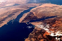
 The Sinai Peninsula with the Gulf of Aqaba to the east and the Gulf of Suez to the west | |
 Gulf of Aqaba | |
| Location | Southwest Asia |
| Coordinates | 28°45′N 34°45′E / 28.750°N 34.750°ECoordinates: 28°45′N 34°45′E / 28.750°N 34.750°E |
| Type | Gulf |
| Native name | خَلِيجُ ٱلْعَقَبَةِ (Arabic) מפרץ אילת (Hebrew) |
| Primary inflows | Red Sea |
| Basin countries | Egypt, Israel, Jordan, and Saudi Arabia |
| Max. length | 160 km (99 mi) |
| Max. width | 24 km (15 mi) |
| Surface area | 239 km2 (92 sq mi) |
| Max. depth | 1,850 m (6,070 ft) |
| Settlements | Aqaba, Eilat, Taba, Haql, Sharm El Sheikh |

The Gulf of Aqaba (Arabic: خَلِيجُ ٱلْعَقَبَةِ, romanized: Khalīj al-ʿAqabah) or Gulf of Eilat (Hebrew: מפרץ אילת, romanized: Mifrátz Eilát) is a large gulf at the northern tip of the Red Sea, east of the Sinai Peninsula and west of the Arabian Peninsula. Its coastline is divided among four countries: Egypt, Israel, Jordan, and Saudi Arabia.
Geography[]
The gulf is east of the Sinai Peninsula and west of the Arabian Peninsula. With the Gulf of Suez to the west, it extends from the northern portion of the Red Sea. It reaches a maximum depth of 1,850 m in its central area: the Gulf of Suez is significantly wider but less than 100 m deep.
The gulf measures 24 kilometres (15 mi) at its widest point and stretches some 160 kilometres (99 mi) north from the Straits of Tiran to where Israel meets Egypt and Jordan.

Like the coastal waters of the Red Sea, the gulf is one of the world's premier sites for diving. The area is especially rich in coral and other marine biodiversity and has accidental shipwrecks and vessels deliberately sunk in an effort to provide a habitat for marine organisms and bolster the local dive tourism industry.
Cities[]
At this northern end of the gulf are three important cities: Taba in Egypt, Eilat in Israel, and Aqaba in Jordan. They are strategically important commercial ports and popular resorts for tourists seeking to enjoy the warm climate. Further south, Haql is the largest Saudi Arabian city on the gulf. On Sinai, Sharm el-Sheikh and Dahab are the major centers.
The largest population center is Aqaba, with a population of 108,000 (2009), followed by Eilat with a population of 48,000 (2009).
Extent[]
The International Hydrographic Organization defines the southern limit of the gulf as "A line running from Southwesterly to (27°57′N 34°36′E / 27.950°N 34.600°E) through Tiran Island to the Southwest point thereof and thence Westward on a parallel (27°54'N) to the coast of the Sinaï Peninsula".[1]
Geology[]
The gulf is one of two gulfs created by the Sinai Peninsula's bifurcation of the northern Red Sea, the Gulf of Suez lying to the west of the peninsula and the Gulf of Aqaba to its east. Geologically, the gulf forms the southern end of the Dead Sea Transform. It contains three small pull-apart basins, the Elat Deep, Aragonese Deep and Dakar Deep, formed between four left lateral strike-slip fault segments. Movement on one of these faults caused the 1995 Gulf of Aqaba earthquake.[2]
Ecology[]
History[]

Trade across the Red Sea between Thebes port of Elim and Elat at the head of the gulf is documented as early as the Fourth Dynasty of Egypt. Expeditions crossing the Red Sea and heading south to Punt are mentioned in the fifth, the sixth, the eleventh, the twelfth and the eighteenth dynasties of Egypt, when Hatshepsut built a fleet to support the trade and journeyed south to Punt in a six-month voyage.[citation needed] Thebes used Nubian gold or Nub from her conquests south into Kush to facilitate the purchase of frankincense, myrrh, bitumen, natron, juniper oil, linen, and copper amulets for the mummification industry at Karnak. Egyptian settlements near Timna at the head of the gulf date to the Eighteenth dynasty of Egypt.
At the northern edge, the ancient city of Ayla (in present-day Aqaba) was a commercial hub for the Nabateans. The Romans built the Via Traiana Nova, which joined the King's Highway at Aqaba and connected Africa to Asia and the Levant and Red Sea shipping.
Aqaba was a major Ottoman port, connected to Damascus and Medina by the Hejaz railway. During World War I, the Battle of Aqaba was the key battle that ended a 500-year Ottoman rule over Greater Syria.
The Marine Twilight Zone Research and Exploration program (MTRX) was set up in 2003 by the Interuniversity Institute for Marine Sciences of Eilat to conduct research on the deep coral reef systems of the northern Red Sea.[3]
Tourism[]
The gulf is one of the most popular diving destinations in the world. About 250,000 dives are performed annually in Eilat's 11 km coastline, and diving represents 10% of the tourism income of this area.[4]
The Landscape of Wadi Rum to the east of the northern edge of the gulf is a popular destination. Other destinations are the ruins of the iron-age civilization of Ayla in the city of Aqaba, the site of the World War I Battle of Aqaba, led by Lawrence of Arabia.
Whales, orcas, dolphins, dugongs, and whale sharks live in the gulf as well.[5][6]
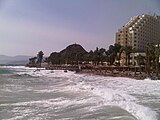
Taba beach
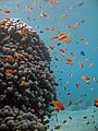
Red Sea coral and marine fish

A resort near Eilat's Coral Beach


See also[]
- Al Jawf Region/Tabuk Region
- Aqaba Governorate
- Israeli Diving Federation
- South Sinai Governorate
- Tourism in Egypt
- Tourism in Israel
- Tourism in Jordan
- Wadi Sayq/Khor Kharfot
References[]
- ^ "Limits of Oceans and Seas, 3rd edition" (PDF). International Hydrographic Organization. 1953. Archived from the original (PDF) on 8 October 2011. Retrieved 28 December 2020.
- ^ Klinger, Yann; Rivera, Luis; Haessler, Henri; Maurin, Jean-Christophe (August 1999). "Active Faulting in the Gulf of Aqaba: New Knowledge from the Mw 7.3 Earthquake of 22 November 1995" (PDF). Bulletin of the Seismological Society of America. Seismological Society of America. 89 (4): 1025–1036. Archived from the original (PDF) on 25 January 2014. Retrieved 23 February 2013.
- ^ Ben-Shaprut, O; Goodman-Tchernov, B (2009). "Exploring the 'Marine Twilight Zone' in the Gulf of Eilat, Red Sea, Israel". In: Pollock NW, ed. Diving for Science 2009. Proceedings of the American Academy of Underwater Sciences 28th Symposium. Dauphin Island, AL: AAUS; 2009. Retrieved 16 April 2013.
- ^ Artificial Reefs and Dive Tourism in Eilat, Israel. Dan Wilhelmsson, Marcus C. Öhman, Henrik Ståhl and Yechiam Shlesinger. Ambio, Vol. 27, No. 8, Building Capacity for Coastal Management (Dec., 1998), pp. 764-766 Published by: Allen Press on behalf of Royal Swedish Academy of Sciences "Archived copy". JSTOR 4314831. Cite journal requires
|journal=(help). the United Nations Environment Programme. Retrieved on 17 December. 2014 - ^ Sciara di N.G., Smeenk C., Rudolph P., Addink M., Baldwin R., Cesario A., Costa M., Feingold D., Fumagalli M., Kerem D., Goffman O., Elasar M., Scheinin A., Hadar N.. 2014. Summary review of cetaceans of the Red Sea.
- ^ "Dugongs in the Red Sea and Gulf of Aden". unep.ch. Archived from the original on 28 January 2016.
External links[]
| Wikimedia Commons has media related to Gulf of Aqaba. |
- The Red Sea Marine Peace Park page on Israel's Ministry of Foreign Affairs - a joint Israel-Jordan initiative
| show Authority control |
|---|
- Bodies of water of the Red Sea
- Gulfs of the Indian Ocean
- Bodies of water of Egypt
- Bodies of water of Israel
- Bodies of water of Jordan
- Gulfs of Saudi Arabia
- Aqaba
- Great Rift Valley
- South Sinai Governorate
- Jordan–Saudi Arabia border
- Israel–Jordan border
- Egypt–Israel border
- Gulfs of Asia