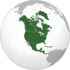
Geography of Cuba
 | |
| Continent | North America |
|---|---|
| Region | Caribbean Sea |
| Coordinates | 22°00′N 80°00′W / 22.000°N 80.000°W |
| Area | Ranked 104th |
| • Total | 109,884 km2 (42,426 sq mi) |
| • Land | 100% |
| • Water | 0% |
| Coastline | 5,746 km (3,570 mi) |
| Borders | None |
| Highest point | Pico Turquino 1,974 metres (6,476 ft) |
| Lowest point | Caribbean Sea 0 m |
| Exclusive economic zone | 350,751 km2 (135,426 sq mi) |

Cuba is an island nation in the Caribbean Sea. Cuba has an official area (land area) of 109,884 km2 (42,426 sq mi). Its area is 110,860 km2 (42,800 sq mi) including coastal and territorial waters. This makes it the 8th largest island country in the world. The main island (Cuba) has 5,746 km (3,570 mi) of coastline and 28.5 km (17.7 mi) of land borders—all figures including the United States territory at Guantánamo Bay, where the U.S. Navy's Guantanamo Bay Naval Base is located.
Cuba lies west of the North Atlantic Ocean, east of the Gulf of Mexico, south of the Straits of Florida, northwest of the Windward Passage, and northeast of the Yucatán Channel. The main island (Cuba) makes up most of the land area 104,556 km2 (40,369 sq mi),[1] and is the seventeenth-largest island in the world by land area.
The island is 1,250 km (780 mi) long and 191 km (119 mi) across its widest points and 31 km (19 mi) across its narrowest points.[1] The largest island outside the main island is the Isla de la Juventud (Isle of Youth) in the southwest, with an area of 2,200 km2 (850 sq mi).[1]
Cuba is an archipelago of islands located in the Caribbean Sea, with the geographic coordinates 21°3N, 80°00W. Cuba is the principal island, which is surrounded by four main groups of islands. These are the Colorados, the Sabana-Camagüey, the Jardines de la Reina and the Canarreos.
The main island consists mostly of flat to rolling plains. At the southeastern end is the Sierra Maestra, a range of steep mountains whose highest point is the Pico Real del Turquino at 1,974 metres (6,476 ft).
Havana is the largest city and capital; other major cities include Santiago de Cuba and Camagüey. Better known smaller towns include Baracoa which was the first Spanish settlement on Cuba, Trinidad, a UNESCO world heritage site, and Bayamo.
Physical geography[]

Cuba is located 77 km (48 mi) west of Haiti across the Windward Passage, 21 km (13 mi) south of The Bahamas (Cay Lobos), 150 km (93 mi) south of the United States (Key West, Florida), 210 km (130 mi) east of Mexico, and 140 km (87 mi) north of Jamaica. It was made in three stages.[2]
Cuba is the largest country by land area in the Caribbean. Its main island is the seventeenth-largest island in the world by land area. The island rises between the Atlantic Ocean and the Caribbean. It is bordered on the north by the Straits of Florida, on the northeast by Nicholas Channel and the Old Bahama Channel. The southern part is bounded by the Windward Passage and the Cayman Trench, while the southwest lies in the Caribbean Sea. To the west, it reaches to the Yucatán Channel, and the northwest is open to the Gulf of Mexico.
More than 4,000 islands and cays are found in the surrounding sea and bays. The southern coast includes such archipelagos as Jardines de la Reina and the Canarreos. The northeastern shore is lined by the Sabana-Camagüey Archipelago, which includes Jardines del Rey and is composed of approximately 2,517 cays and islands.[3] The Colorados Archipelago is developed on the north-western coast.
Terrain[]
Cuba's terrain is mostly flat or rolling plains, with rugged hills and mountains in the southeast. The lowest point is the Caribbean Sea at 0 m (sea level) and the highest point is Pico Turquino at 1,974 m (6,476 ft), part of the Sierra Maestra mountain range, located in the southeast of the island.
Other mountain ranges are Sierra Cristal in the southeast, Escambray Mountains in the center of the island, and Sierra del Rosario in the northwest. White sand beaches (most notably in Varadero[4]), as well as mangroves and marshes can be found in the coastal area. The largest is the Zapata Swamp, with over 4,520 km2 (1,750 sq mi). A recent global remote sensing analysis suggested that there were 675km² of tidal flats in Cuba, making it the 38th ranked country in terms of tidal flat area.[5]
Cuba has negligible inland water area. The largest natural water mirror is Laguna de Leche at 67.2 km2 (25.9 sq mi), while the man-made Zaza Reservoir, at 113.5 km2 (43.8 sq mi), is the largest inland water surface by area in the country.
Geology[]
Maritime claims[]
Cuba makes maritime claims that include a territorial sea of 12 nautical miles (22.2 km; 13.8 mi) and an exclusive economic zone of 350,751 km2 (135,426 sq mi) with 200 nautical miles (370.4 km; 230.2 mi).
Extreme points[]

Extreme points in Cuba are:
| Point | Name | Location | Remarks |
|---|---|---|---|
| North (on-shore) | Punta Hicacos | 23°12′23″N 81°08′44″W / 23.20639°N 81.14556°W | On Hicacos Peninsula |
| North (off-shore) | Cayo Cruz del Padre | 23°16′34″N 80°54′38″W / 23.27611°N 80.91056°W | Part of Sabana-Camagüey Archipelago |
| East | Cape Maisí | 20°12′32″N 74°08′01″W / 20.20889°N 74.13361°W | Near Maisí |
| West | Cape San Antonio | 21°51′39″N 84°57′25″W / 21.86083°N 84.95694°W | On Guanahacabibes Peninsula |
| South | Cape Cruz | 19°49′37″N 77°40′30″W / 19.82694°N 77.67500°W | Near Niquero |
| Highest point | Pico Turquino | 19°59′22″N 76°50′09″W / 19.98944°N 76.83583°W | Part of Sierra Maestra, 1,974 m (6,476 ft) |
| Lowest point | sea level | Caribbean and Atlantic Ocean | |
| Largest city | Havana | 23°08′00″N 82°23′00″W / 23.13333°N 82.38333°W | National capital, population 2,130,431 |
| Oldest city | Baracoa | 20°20′55″N 74°30′38″W / 20.34861°N 74.51056°W | Founded in 1511 |
Natural resources[]
Natural resources include cobalt, nickel, iron ore, copper, salt, timber, silica, oil and petroleum. At one time, the whole island was covered with forests and there are still many cedar (Cedrela odorata), chechem (Metopium brownei), mahogany (Swietenia mahagoni), and other valuable trees. Large areas were cleared to grow more sugarcane, and so few trees remained that timber had to be imported.
The most important Cuban mineral economic resource is nickel. Cuba has the second largest nickel reserves in the world after Russia.[6] Sherritt International, a Canadian energy company, operates a large nickel mining facility in Moa, Cuba. Another leading mineral resource is cobalt, a byproduct of nickel mining operations. Cuba ranks as the fifth largest producer of refined cobalt in the world.
Cuba has historically been dependent on oil imports.[7] As of 2011, Cuba had proven reserves of a mere 0.1 billion barrels (16,000,000 m3) of crude oil and 2.5 trillion cubic feet of natural gas, and mostly used oil for power generation.[7] In 2010, Cuba produced 51,000 barrels of crude oil a day (Kb/d) in 2010 in onshore or shallow near-shore development, "mostly heavy, sour (sulfur-rich) crude that requires advanced refining capacity to process."[7] Offshore exploration in the North Cuba Basin had revealed the possibility of an additional 4.6 billion barrels (730,000,000 m3) of technically recoverable crude oil, 0.9 billion barrels of natural gas liquids, and 9.8 trillion cubic feet of natural gas.[7] As of 2011, Cuba had six offshore petroleum development projects with foreign oil companies Petrovietnam (Vietnam), Petronas (Malaysia), PDVSA (Venezuela), Sonangol (Angola), ONGC (India), Repsol (Spain), and Statoil (Norway).[7]
Sugarcane was historically the most important part of the Cuban economy,[8] and is still grown on large areas; in 2018, Cuba produced an estimated 1.1–1.3 million tonnes of raw sugar.[9] The importance of the sugar harvest has declined, with tourism, tobacco, nickel, and pharmaceuticals surpassing sugar in economic importance.[9]
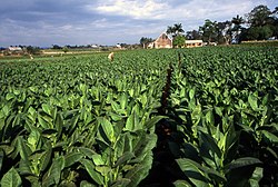
Extensive irrigation systems are developed in the south of Sancti Spíritus Province. Tobacco, used for some of the world's cigars, is grown especially in the Pinar del Río Province.
Climate[]

| Casa Blanca, Havana | ||||||||||||||||||||||||||||||||||||||||||||||||||||||||||||
|---|---|---|---|---|---|---|---|---|---|---|---|---|---|---|---|---|---|---|---|---|---|---|---|---|---|---|---|---|---|---|---|---|---|---|---|---|---|---|---|---|---|---|---|---|---|---|---|---|---|---|---|---|---|---|---|---|---|---|---|---|
| Climate chart (explanation) | ||||||||||||||||||||||||||||||||||||||||||||||||||||||||||||
| ||||||||||||||||||||||||||||||||||||||||||||||||||||||||||||
| ||||||||||||||||||||||||||||||||||||||||||||||||||||||||||||
Most of Cuba has a tropical savanna climate (Aw) according to the Köppen Climate classification, though some areas also have a tropical monsoon climate and a tropical rainforest climate, with a hot semi-arid climate in the Guantánamo Bay area. In most areas, the dry season lasts from November to April and the rainy season from May to October.
The climate is tropical, though moderated by trade winds. In general (with local variations), there is a drier season from November to April, and a rainier season from May to October. The average temperature is 23.1 °C (73.6 °F) in January and 27 °C (80.6 °F) in July.
Cuba lies in the path of hurricanes, and these destructive storms are most common in September and October. Tornadoes are somewhat rare in Cuba, however, on the evening of January 27, 2019, a very rare strong F4 tornado struck the eastern side of Havana, Cuba's capital city. The tornado caused extensive damage, destroying at least 90 homes, killing four people and injuring 195.[11][12][13][14] By February 4, the death toll had increased to six, with 11 people still in critical condition.[15]
Administrative subdivisions[]
Cuba is divided into 15 provinces and one special municipality. Provinces are further subdivided into 168 municipalities.[16]
References[]
- ^ Jump up to: a b c Stoner, K. Lynn. "Cuba" Encarta Online Encyclopedia. 2005. Archived 2009-10-29 at the Wayback Machine 2009-10-31.
- ^ Iturralde-Vinent, M. A.; García-Casco, A.; Rojas-Agramonte, Y.; Proenza, J. A.; Murphy, J. B.; Stern, R. J. (2016). "The geology of Cuba: A brief overview and synthesis". GSA Today. 26 (10): 4–10. doi:10.1130/GSATG296A.1.
- ^ Menéndez, Leda; Guzmán, José Manuel; Capote, René Tomas; González, Armando Vicente; Rodríguez, Lázaro (March 2005). "Variabilidad de los bosques de manglares del archipiélago Sabana- Camagüey: Implicaciones para su gestión". Mapping Interactivo: Revista Internacional de Ciencias de la Tierra. 100. ISSN 1131-9100. Archived from the original on May 22, 2006. Retrieved 2007-10-16.
- ^ Varadero – YouTube
- ^ Murray, N.J.; Phinn, S.R.; DeWitt, M.; Ferrari, R.; Johnston, R.; Lyons, M.B.; Clinton, N.; Thau, D.; Fuller, R.A. (2019). "The global distribution and trajectory of tidal flats". Nature. 565 (7738): 222–225. doi:10.1038/s41586-018-0805-8. PMID 30568300. S2CID 56481043.
- ^ http://minerals.usgs.gov/minerals/pubs/country/1997/9509097.pdf The Mineral Resources of Cuba 1997
- ^ Jump up to: a b c d e Neelesh Nerurkar & Mark P. Sullivan, Cuba's Offshore Oil Development: Background and U.S. Policy Considerations, Congressional Research Service (November 28, 2011).
- ^ Pollitt, Brian H. (2004). "The Rise and Fall of the Cuban Sugar Economy". Journal of Latin American Studies. 36 (2): 319–348. doi:10.1017/S0022216X04007448. JSTOR 3875618.
- ^ Jump up to: a b Marc Frank, Cuban raw sugar production headed toward 30 percent decline, Reuters (April 16, 2018).
- ^ Cuba Climate data
- ^ "Havana tornado: Cuba's capital hit by rare twister". BBC News. Retrieved 28 January 2019.
- ^ http://www.startribune.com/the-latest-resident-havana-looks-like-a-horror-movie/504962142/
- ^ https://www.cnn.com/2019/01/28/americas/cuba-tornado-dead-scli-intl/index.html
- ^ Cappucci, Matthew (28 January 2019). "A deadly tornado plowed through Havana on Sunday night. Here's how it happened". The Washington Post. Retrieved 29 January 2019.
- ^ "Death Toll Rises to Six From Rare Havana Tornado". Weather Underground. 4 February 2019. Retrieved 5 February 2019.
- ^ Fifth United Nations Conference on the Standardization of Geographical Names, Vol. II, published by the United Nations, New York, 1991
External links[]
| Wikimedia Commons has media related to Geography of Cuba. |
- Map of the Complete Island of Cuba from 1639
| show |
|---|
- Geography of Cuba