Geography of Canada
| Continent | North America |
|---|---|
| Region | Northern America |
| Coordinates | 60°00′N 95°00′W / 60.000°N 95.000°W |
| Area | Ranked 2nd |
| • Total | 9,984,671 km2 (3,855,103 sq mi) |
| • Land | 91.08% |
| • Water | 8.92% |
| Coastline | 243,042 km (151,019 mi) |
| Borders | 8,893 km |
| Highest point | Mount Logan, 5,959 m (19,551 ft) |
| Lowest point | Atlantic Ocean, Sea Level |
| Longest river | Mackenzie River, 4,241 km (2,635 mi) |
| Largest lake | Great Bear Lake 31,153 km2 (12,028 sq mi) |
| Climate | temperate, or humid continental to subarctic or arctic in north, and tundra in mountainous areas, and the far north |
| Terrain | mostly plains and mountains in west, to highlands (low mountains) in the south east, and east, to flatlands in the Great lakes |
| Natural resources | iron ore, nickel, zinc, copper, gold, lead, molybdenum, potash, diamonds, silver, fish, timber, wildlife, coal, petroleum, natural gas, hydropower |
| Natural hazards | permafrost, cyclonic storms, tornadoes, earthquakes, forest fires |
| Environmental issues | air and water pollution, acid rains |
| Exclusive economic zone | 5,599,077 km2 (2,161,816 sq mi) |
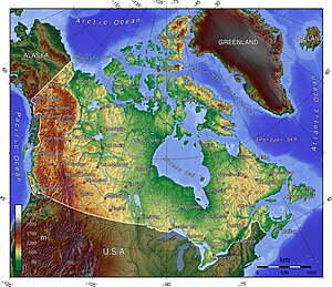

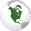
Canada has a vast geography that occupies much of the continent of North America, sharing land borders with the contiguous United States to the south and the U.S. state of Alaska to the northwest. Canada stretches from the Atlantic Ocean in the east to the Pacific Ocean in the west; to the north lies the Arctic Ocean.[1] Greenland is to the northeast and to the southeast Canada shares a maritime boundary with France's overseas collectivity of Saint Pierre and Miquelon, the last vestige of New France.[2] By total area (including its waters), Canada is the second-largest country in the world, after Russia. By land area alone, however, Canada ranks fourth, the difference being due to it having the world's largest proportion of fresh water lakes.[3] Of Canada's thirteen provinces and territories, only two are landlocked (Alberta and Saskatchewan) while the other eleven all directly border one of three oceans.
Canada is home to the world's northernmost settlement, Canadian Forces Station Alert, on the northern tip of Ellesmere Island—latitude 82.5°N—which lies 817 kilometres (508 mi) from the North Pole.[4] Much of the Canadian Arctic is covered by ice and permafrost.[5] Canada has the longest coastline in the world, with a total length of 243,042 kilometres (151,019 mi);[6] additionally, its border with the United States is the world's longest land border, stretching 8,891 kilometres (5,525 mi).[7] Three of Canada's Arctic islands, Baffin Island, Victoria Island and Ellesmere Island, are among the ten largest in the world.[8]
Canada is divided into fifteen terrestrial and five marine ecozones,[9] encompassing over 80,000 classified species of life.[10] Since the end of the last glacial period, Canada has consisted of eight distinct forest regions, including extensive boreal forest on the Canadian Shield;[11] 42 percent of the land acreage of Canada is covered by forests (approximately 8 percent of the world's forested land), made up mostly of spruce, poplar and pine.[12] Canada has over 2,000,000 lakes—563 greater than 100 km2 (39 sq mi)—which is more than any other country, containing much of the world's fresh water.[13][14] There are also freshwater glaciers in the Canadian Rockies, the Coast Mountains and the Arctic Cordillera.[15] A recent global remote sensing analysis also suggested that there were 6,477km² of tidal flats in Canada, making it the 5th ranked country in terms of how much tidal flat occurs there.[16] Protected areas of Canada and National Wildlife Areas have been established to preserve ecosystems.[17]
Canada is geologically active, having many earthquakes and potentially active volcanoes, notably the Mount Meager massif, Mount Garibaldi, the Mount Cayley massif, and the Mount Edziza volcanic complex.[18] Average winter and summer high temperatures across Canada range from Arctic weather in the north, to hot summers in the southern regions, with four distinct seasons.
Physiography []

Canada covers 9,984,670 km2 (3,855,100 sq mi) and a panoply of various geoclimatic regions, of which there are 8 main regions.[19] Canada also encompasses vast maritime terrain, with the world's longest coastline of 243,042 kilometres (151,019 mi).[20] The physical geography of Canada is widely varied. Boreal forests prevail throughout the country, ice is prominent in northerly Arctic regions and through the Canadian Rocky Mountains, and the relatively flat Canadian Prairies in the southwest facilitate productive agriculture.[19] The Great Lakes feed the St. Lawrence River (in the southeast) where lowlands host much of Canada's population.
Appalachian Mountains[]
The Appalachian mountain range extends from Alabama in southern United States through the Gaspé Peninsula and the Atlantic Provinces, creating rolling hills indented by river valleys.[21] It also runs through parts of southern Quebec.[21]
The Appalachian Mountains (more specifically the Chic-Choc, Notre Dame, and Long Range Mountains) are an old and eroded range of mountains, approximately 380 million years in age. Notable mountains in the Appalachians include Mount Jacques-Cartier (Quebec, 1,268 m or 4,160 ft), Mount Carleton (New Brunswick, 817 m or 2,680 ft), The Cabox (Newfoundland, 814 m or 2,671 ft).[22] Parts of the Appalachians are home to a rich endemic flora and fauna and are considered to have been nunataks during the last glaciation era.
Great Lakes and St. Lawrence Lowlands[]

The southern parts of Quebec and Ontario, in the section of the Great Lakes (bordered entirely by Ontario on the Canadian side) and St. Lawrence River basin (often called St. Lawrence Lowlands), is another particularly rich sedimentary plain.[23] Prior to its colonization and heavy urban sprawl of the 20th century, this Eastern Great Lakes lowland forests area was home to large mixed forests covering a mostly flat area of land between the Appalachian Mountains and the Canadian Shield.[24] Most of this forest has been cut down through agriculture and logging operations, but the remaining forests are for the most part heavily protected. In this part of Canada begins one of the world's largest estuaries, the Estuary of Saint Lawrence (see Gulf of St. Lawrence lowland forests).[25]
While the relief of these lowlands is particularly flat and regular, a group of batholites known as the Monteregian Hills are spread along a mostly regular line across the area.[26] The most notable are Montreal's Mount Royal and Mont Saint-Hilaire. These hills are known for a great richness in precious minerals.[26]
Canadian Shield[]

The northeastern part of Alberta, northern parts of Saskatchewan, Manitoba, Ontario and Quebec, all of Labrador and the Great Northern Peninsula of Newfoundland, eastern mainland Northwest Territories, most of Nunavut's mainland and, of its Arctic Archipelago, Baffin Island and significant bands through Somerset, Southampton, Devon and Ellesmere islands are located on a vast rock base known as the Canadian Shield.[27] The Shield mostly consists of eroded hilly terrain and contains many lakes and important rivers used for hydroelectric production, particularly in northern Quebec and Ontario. The Shield also encloses an area of wetlands around the Hudson Bay. Some particular regions of the Shield are referred to as mountain ranges, including the Torngat and Laurentian Mountains.[28]
The Shield cannot support intensive agriculture, although there is subsistence agriculture and small dairy farms in many of the river valleys and around the abundant lakes, particularly in the southern regions. Boreal forest covers much of the shield, with a mix of conifers that provide valuable timber resources in areas such as the Central Canadian Shield forests ecoregion that covers much of Northern Ontario.
The Canadian Shield is known for its vast mineral reserves such as emeralds, diamonds and copper, and is there also called the "mineral house".[28]
Canadian Interior Plains[]

The Canadian Prairies, the Canadian portion of the Great Plains, are part of a vast sedimentary plain covering much of Alberta, southern Saskatchewan, and southwestern Manitoba, as well as much of the Taiga and Boreal region between the Canadian Rockies and the Great Slave and Great Bear Lakes in Northwest Territories. The plains generally describes the expanses of (largely flat) arable agricultural land which sustain extensive grain-farming operations in the southern part of the provinces. Despite this, some areas such as the Cypress Hills and the Alberta Badlands are quite hilly and the prairie provinces contain large areas of forest such as the Mid-Continental Canadian forests. The size is roughly ~1,900,000 km2 (733,594.1 sq mi).
Canadian Arctic[]
While the largest part of the Canadian Arctic is composed of seemingly endless permafrost and tundra north of the tree line, it encompasses geological regions of varying types: the Arctic Cordillera (with the British Empire Range and the United States Range on Ellesmere Island) contains the northernmost mountain system in the world. The Arctic Lowlands and Hudson Bay lowlands comprise a substantial part of the geographic region often designated as the Canadian Shield (in contrast to the sole geologic area). The ground in the Arctic is mostly composed of permafrost, making construction difficult and often hazardous, and agriculture virtually impossible.
The Arctic, when defined as everything north of the tree line, covers most of Nunavut and the northernmost parts of Northwest Territories, Yukon, Manitoba, Ontario, Quebec and Labrador.
Western Cordillera[]

The Coast Mountains in British Columbia run from the lower Fraser River and the Fraser Canyon northwestward, separating the Interior Plateau from the Pacific Ocean.[29] Its southeastern end is separated from the North Cascades by the Fraser Lowland, where nearly a third of Western Canada's population reside.
The coastal flank of the Coast Mountains is characterized by an intense network of fjords and associated islands, very similar to the Norwegian coastline in Northern Europe; while their inland side transitions to the high plateau with dryland valleys notable for a series of large alpine lakes similar to those in southern Switzerland, beginning in deep mountains and ending in flatland. They are subdivided in three main groups, the Pacific Ranges between the Fraser River and Bella Coola, the Kitimat Ranges from there northwards to the Nass River, and the Boundary Ranges from there to the mountain terminus in Yukon at Champagne Pass and Chilkat Pass northwest of Haines, Alaska.[29] The Saint Elias Mountains lie to their west and northwest, while the Yukon Ranges and Yukon Basin lie to their north. On the inland side of the Boundary Ranges are the Tahltan and Tagish Highlands and also the Skeena Mountains, part of the Interior Mountains system, which also extend southwards on the inland side of the Kitimat Ranges.[29]
The terrain of the main spine of the Coast Mountains is typified by heavy glaciation, including several very large icefields of varying elevation. Of the three subdivisions, the Pacific Ranges are the highest and are crowned by Mount Waddington, while the Boundary Ranges contain the largest icefields, the Juneau Icefield being the largest. The Kitimat Ranges are lower and less glacier-covered than either of the other two groupings, but are extremely rugged and dense.
The Coast Mountains are made of igneous and metamorphic rock from an episode of arc volcanism related to subduction of the Kula and Farallon Plates during the Laramide orogeny about 100 million years ago.[30] The widespread granite forming the Coast Mountains formed when magma intruded and cooled at depth beneath volcanoes of the Coast Range Arc whereas the metamorphic formed when intruding magma heated the surrounding rock to produce schist.
The Insular Mountains extend from Vancouver Island in the south to the Queen Charlotte Islands in the north on the British Columbia Coast. It contains two main mountain ranges, the Vancouver Island Ranges on Vancouver Island and the Queen Charlotte Mountains on the Queen Charlotte Islands.[31]
Extreme points[]
The northernmost point of land within the boundaries of Canada is Cape Columbia, Ellesmere Island, Nunavut 83°06′40″N 69°58′19″W / 83.111°N 69.972°W.[32] The northernmost point of the Canadian mainland is Zenith Point on Boothia Peninsula, Nunavut 72°00′07″N 94°39′18″W / 72.002°N 94.655°W.[32] The southernmost point is Middle Island, in Lake Erie, Ontario (41°41′N 82°40′W); the southernmost water point lies just south of the island, on the Ontario–Ohio border (41°40′35″N). The southernmost point of the Canadian mainland is Point Pelee, Ontario 41°54′32″N 82°30′32″W / 41.909°N 82.509°W.[32] The lowest point is sea level at 0 m,[33] whilst the highest point is Mount Logan, Yukon, at 5,959 m / 19,550 ft 60°34′01″N 140°24′18″W / 60.567°N 140.405°W.[32]
The westernmost point is Boundary Peak 187 (60°18′22.929″N 141°00′7.128″W) at the southern end of the Yukon–Alaska border, which roughly follows 141°W but leans very slightly east as it goes North 60°18′04″N 141°00′36″W / 60.301°N 141.010°W.[34][32] The easternmost point is Cape Spear, Newfoundland (47°31′N 52°37′W) 47°31′23″N 52°37′08″W / 47.523°N 52.619°W.[32] The easternmost point of the Canadian mainland is Elijah Point, Cape St. Charles, Labrador (52°13′N 55°37′W) 52°13′01″N 55°37′16″W / 52.217°N 55.621°W.[32]
The Canadian pole of inaccessibility is allegedly near Jackfish River, Alberta (59°2′N 112°49′W).[35] The furthest straight-line distance that can be travelled to Canadian points of land is between the southwest tip of Kluane National Park and Reserve (next to Mount Saint Elias) and Cripple Cove, Newfoundland (near Cape Race) at a distance of 3,005.60 nautical miles (5,566.37 km; 3,458.78 mi).
Climatology []
Canada has a diverse climate. The climate varies from temperate on the west coast of British Columbia[36] to a subarctic climate in the north.[37] Extreme northern Canada can have snow for most of the year with a Polar climate.[38] Landlocked areas tend to have a warm summer continental climate zone[39] with the exception of Southwestern Ontario which has a hot summer humid continental climate.[39] Parts of Western Canada have a semi-arid climate, and parts of Vancouver Island can even be classified as a warm-summer Mediterranean climate.[38] Temperature extremes in Canada range from 49.5 °C (121.1 °F) in Lytton, British Columbia,[40] on 29 June 2021, to −63.0 °C (−81.4 °F) in Snag, Yukon, on 3 February 1947.[41]

| City | July (°C) | July (°F) | January (°C) | January (°F) |
|---|---|---|---|---|
| Calgary[42] | 23/9 | 73/48 | −1/−13 | 27/8 |
| Charlottetown[43] | 23/14 | 78/54 | −3/−13 | 26/9 |
| Edmonton[44] | 23/12 | 73/54 | −6/−15 | 22/13 |
| Fredericton[45] | 26/13 | 78/54 | −4/−16 | 25/4 |
| Halifax[46] | 23/14 | 73/58 | 0/−9 | 32/17 |
| Iqaluit[47] | 12/4 | 53/39 | −23/−31 | −9/−24 |
| Montreal[48] | 26/16 | 79/60 | −5/−12 | 22/6 |
| Ottawa[49] | 27/15 | 80/60 | −6/−15 | 21/5 |
| Quebec City[50] | 25/13 | 77/56 | −8/−18 | 18/0 |
| Regina[51] | 26/11 | 79/52 | −10/−22 | 14/−8 |
| Saskatoon[52] | 25/11 | 77/52 | −12/−22 | 10/−8 |
| St. John's[53] | 20/11 | 69/51 | −1/−9 | 30/17 |
| Toronto[54] | 26/18 | 80/64 | −1/−7 | 30/19 |
| Whitehorse[55] | 21/8 | 70/46 | −11/−20 | 12/−4 |
| Windsor[56] | 28/17 | 82/63 | −1/−8 | 30/17 |
| Winnipeg[57] | 26/13 | 79/55 | −13/−20 | 9/−4 |
| Vancouver[58] | 22/13 | 71/54 | 6/1 | 43/33 |
| Victoria[59] | 22/11 | 71/51 | 7/1 | 44/33 |
| Yellowknife[60] | 21/13 | 70/55 | −22/−30 | −8/−22 |
Biogeography[]

Canada is divided into fifteen major terrestrial and five marine ecozones, that are further subdivided into 53 ecoprovinces, 194 ecoregions, and 1,027 ecodistricts.[9] These eco-areas encompass over 80,000 classified species of Canadian wildlife, with an equal number yet to be formally recognized or discovered.[61] Due to pollution, loss of biodiversity, over-exploitation of commercial species, invasive species, and habitat loss, there are currently more than 800 wild life species at risk of being lost.[62]
Canada's major biomes are the tundra, boreal forest, grassland, and temperate deciduous forest. British Columbia contains several smaller biomes, including; mountain forest which extends to Alberta, and a small temperate rainforest along the Pacific coast, the semi arid desert located in the Okanagan and alpine tundra in the higher mountainous regions.[63]
Over half of Canada's landscape is intact and relatively free of human development.[64] Approximately half of Canada is covered by forest, totaling around 2.4 million km2 (0.93 million sq mi).[65] The boreal forest of Canada is considered to be the largest intact forest on earth, with around 300,000 square kilometres (120,000 sq mi) undisturbed by roads, cities or industry.[66] The Canadian Arctic tundra is the second-largest vegetation region in the country consisting of dwarf shrubs, sedges and grasses, mosses and lichens.[67]
Approximately 12.1 percent of the nation's landmass and freshwater are conservation areas, including 11.4 percent designated as protected areas.[17] Approximately 13.8 percent of its territorial waters are conserved, including 8.9 percent designated as protected areas.[17]
Palaeogeography[]

Western Canada has many volcanoes and is part of the Pacific Ring of Fire, a system of volcanoes found around the margins of the Pacific Ocean. There are over 200 young volcanic centres that stretch northward from the Cascade Range to Yukon. They are grouped into five volcanic belts with different volcano types and tectonic settings. The Northern Cordilleran Volcanic Province was formed by faulting, cracking, rifting, and the interaction between the Pacific Plate and the North American Plate. The Garibaldi Volcanic Belt was formed by subduction of the Juan de Fuca Plate beneath the North American Plate. The Anahim Volcanic Belt was formed as a result of the North American Plate sliding westward over the Anahim hotspot. The Chilcotin Group is believed to have formed as a result of back-arc extension behind the Cascadia subduction zone. The Wrangell Volcanic Field formed as a result of subduction of the Pacific Plate beneath the North American Plate at the easternmost end of the Aleutian Trench. The volcanic eruption of the Tseax Cone in 1775 was among Canada's worst natural disasters, killing an estimated 2,000 Nisga'a people and destroying their village in the Nass River valley of northern British Columbia.[68] The eruption produced a 22.5-kilometre (14.0 mi) lava flow, and, according to Nisga'a legend, blocked the flow of the Nass River.[69]
Volcanism has also occurred in the Canadian Shield. It contains over 150 volcanic belts (now deformed and eroded down to nearly flat plains) that range from 600 million to 2.8 billion years old. Many of Canada's major ore deposits are associated with Precambrian volcanoes. There are pillow lavas in the Northwest Territories that are about 2.6 billion years old and are preserved in the Cameron River Volcanic Belt. The pillow lavas in rocks over 2 billion years old in the Canadian Shield signify that great oceanic volcanoes existed during the early stages of the formation of the Earth's crust. Ancient volcanoes play an important role in estimating Canada's mineral potential. Many of the volcanic belts bear ore deposits that are related to the volcanism.
Hydrography[]

Canada holds vast reserves of water: its rivers discharge nearly 7% of the world's renewable water supply,[70] Canada has over 2,000,000 lakes—563 greater than 100 square kilometres (39 sq mi)—which is more than any other country and has the third largest amount of glacier water.[71] Canada is also home to about twenty five percent (134.6 million ha) of the world's wetlands that support a vast array of local ecosystems.[72]
Canada's waterways host forty seven rivers of at least 600 square kilometres (230 sq mi) in length, with the two longest being the Mackenzie River, that begins at Great Slave Lake and ends in the Arctic Ocean, with its drainage basin covering a large part of northwestern Canada, and the Saint Lawrence River, which drains the Great Lakes into the Gulf of St. Lawrence ending in the Atlantic Ocean. The Mackenzie, including its tributaries is over 4,200 square kilometres (1,600 sq mi) in length and lies within the second largest drainage basin of North America, while the St. Lawrence 3,058 square kilometres (1,181 sq mi) in length, drains the world's largest system of freshwater lakes.[73]
The Atlantic watershed drains the entirety of the Atlantic provinces (parts of the Quebec-Labrador border are fixed at the Atlantic Ocean-Arctic Ocean continental divide), most of inhabited Quebec and large parts of southern Ontario. It is mostly drained by the economically important St. Lawrence River and its tributaries, notably the Saguenay, Manicouagan and Ottawa rivers. The Great Lakes and Lake Nipigon are also drained by the St. Lawrence. The Churchill River and Saint John River are other important elements of the Atlantic watershed in Canada.[74]

The Hudson Bay watershed drains over a third of Canada. It covers Manitoba, northern Ontario and Quebec, most of Saskatchewan, southern Alberta, southwestern Nunavut and the southern half of Baffin Island. This basin is most important in fighting drought in the prairies and producing hydroelectricity, especially in Manitoba, northern Ontario and Quebec. Major elements of this watershed include Lake Winnipeg, Nelson River, the North Saskatchewan and South Saskatchewan Rivers, Assiniboine River, and Nettilling Lake on Baffin Island. Wollaston Lake lies on the boundary between the Hudson Bay and Arctic Ocean watersheds and drains into both. It is the largest lake in the world that naturally drains in two directions.[74]
The continental divide in the Rockies separates the Pacific watershed in British Columbia and Yukon from the Arctic and Hudson Bay watersheds. This watershed irrigates the agriculturally important areas of inner British Columbia (such as the Okanagan and Kootenay valleys), and is used to produce hydroelectricity. Major elements are the Yukon, Columbia and Fraser rivers.[74]
The northern parts of Alberta, Manitoba and British Columbia, most of Northwest Territories and Nunavut, and parts of Yukon are drained by the Arctic watershed. This watershed has been little used for hydroelectricity, with the exception of the Mackenzie River. The Peace, Athabasca and Liard Rivers, as well as Great Bear Lake and Great Slave Lake (respectively the largest and second largest lakes wholly enclosed by Canada) are significant elements of the Arctic watershed. Each of these elements eventually merges with the Mackenzie, thereby draining the vast majority of the Arctic watershed.[74]
The southernmost part of Alberta drains into the Gulf of Mexico through the Milk River and its tributaries. The Milk River originates in the Rocky Mountains of Montana, then flows into Alberta, then returns into the United States, where it is drained by the Missouri River. A small area of southwestern Saskatchewan is drained by Battle Creek, which empties into the Milk River.[74]
Natural resources[]
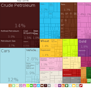
Canada's abundance of natural resources is reflected in their continued importance in the economy of Canada. Major resource-based industries are fisheries, forestry, agriculture, petroleum products and mining.
The fisheries industry has historically been one of Canada's strongest. Unmatched cod stocks on the Grand Banks of Newfoundland launched this industry in the 16th century. Today these stocks are nearly depleted, and their conservation has become a preoccupation of the Atlantic Provinces. On the West Coast, tuna stocks are now restricted. The less depleted (but still greatly diminished) salmon population continues to drive a strong fisheries industry. Canada claims 22 km (12 nmi) of territorial sea, a contiguous zone of 44 km (24 nmi), an exclusive economic zone of 5,599,077 km2 (2,161,816 sq mi) with 370 km (200 nmi) and a continental shelf of 370 km (200 nmi) or to the edge of the continental margin.
Five per cent of Canada's land area is arable, none of which is for permanent crops. Three per cent of Canada's land area is covered by permanent pastures. Canada has 7,200 square kilometres (2,800 mi2) of irrigated land (1993 estimate). Agricultural regions in Canada include the Canadian Prairies, the Lower Mainland and various regions within the Interior of British Columbia, the St. Lawrence Basin and the Canadian Maritimes. Main crops in Canada include flax, oats, wheat, maize, barley, sugar beets and rye in the prairies; flax and maize in Western Ontario; Oats and potatoes in the Maritimes. Fruit and vegetables are grown primarily in the Annapolis Valley of Nova Scotia, Southwestern Ontario, the Golden Horseshoe region of Ontario, along the south coast of Georgian Bay and in the Okanagan Valley of British Columbia. Cattle and sheep are raised in the valleys and plateaus of British Columbia. Cattle, sheep and hogs are raised on the prairies, cattle and hogs in Western Ontario, sheep and hogs in Quebec, and sheep in the Maritimes. There are significant dairy regions in central Nova Scotia, southern New Brunswick, the St. Lawrence Valley, northeastern Ontario, southwestern Ontario, the Red River valley of Manitoba and the valleys in the British Columbia Interior, on Vancouver Island and in the Lower Mainland.

Fossil fuels are a more recently developed resource in Canada, with oil and gas being extracted from deposits in the Western Canadian Sedimentary Basin since the mid 1900s. While Canada's crude oil deposits are fewer, technological developments in recent decades have opened up oil production in Alberta's Oil Sands to the point where Canada now has some of the largest reserves of oil in the world. In other forms, Canadian industry has a long history of extracting large coal and natural gas reserves.
Canada's mineral resources are diverse and extensive. Across the Canadian Shield and in the north there are large iron, nickel, zinc, copper, gold, lead, molybdenum, and uranium reserves. Large diamond concentrations have been recently developed in the Arctic, making Canada one of the world's largest producers. Throughout the Shield there are many mining towns extracting these minerals. The largest, and best known, is Sudbury, Ontario. Sudbury is an exception to the normal process of forming minerals in the Shield since there is significant evidence that the Sudbury Basin is an ancient meteorite impact crater. The nearby, but less known Temagami Magnetic Anomaly has striking similarities to the Sudbury Basin. Its magnetic anomalies are very similar to the Sudbury Basin, and so it could be a second metal-rich impact crater.[75] The Shield is also covered by vast boreal forests that support an important logging industry.
Canada's many rivers have afforded extensive development of hydroelectric power. Extensively developed in British Columbia, Ontario, Quebec and Labrador, the many dams have long provided a clean, dependable source of energy.
Environmental issues[]

Air pollution and resulting acid rain severely affects lakes and damages forests.[76] Metal smelting, coal-burning utilities, and vehicle emissions impact agricultural and forest productivity. Ocean waters are also becoming contaminated by agricultural, industrial, mining, and forestry activities.[76]
Global climate change and the warming of the polar region will likely cause significant changes to the environment, including loss of the polar bear,[77] the exploration for resource then the extraction of these resources and an alternative transport route to the Panama Canal through the Northwest Passage.
Canada is currently warming at twice the global average, and this is effectively irreversible.[78]
Political geography[]
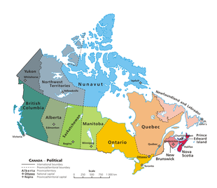
Canada is divided into ten provinces and three territories. According to Statistics Canada, 72.0 percent of the population is concentrated within 150 kilometres (93 mi) of the nation's southern border with the United States, 70.0% live south of the 49th parallel, and over 60 percent of the population lives along the Great Lakes and St. Lawrence River between Windsor, Ontario, and Quebec City. This leaves the vast majority of Canada's territory as sparsely populated wilderness; Canada's population density is 3.5 people/km2 (9.1/mi2), among the lowest in the world. Despite this, 79.7 percent of Canada's population resides in urban areas, where population densities are increasing.[79]
Canada shares with the U.S. the world's longest binational border at 8,893 kilometres (5,526 mi); 2,477 kilometres (1,539 mi) are with Alaska. The Danish island dependency of Greenland lies to Canada's northeast, separated from the Canadian Arctic islands by Baffin Bay and Davis Strait. The French islands of Saint Pierre and Miquelon lie off the southern coast of Newfoundland in the Gulf of St. Lawrence and have a maritime territorial enclave within Canada's exclusive economic zone.[80]
Canada's geographic proximity to the United States has historically bound the two countries together in the political world as well. Canada's position between the Soviet Union (now Russia) and the U.S. was strategically important during the Cold War since the route over the North Pole and Canada was the fastest route by air between the two countries and the most direct route for intercontinental ballistic missiles. Since the end of the Cold War, there has been growing speculation that Canada's Arctic maritime claims may become increasingly important if global warming melts the ice enough to open the Northwest Passage.
See also[]

- Atlas of Canada
- Canadian Geographic
- Canadian Rockies
- Extreme points of North America
- List of highest points of Canadian provinces and territories
- List of Ultras of Canada
- Mountain peaks of Canada
- Temperature in Canada
 Canada portal
References[]
- ^ "Canada". The World Factbook. CIA. 16 May 2006. Retrieved 23 May 2011.
- ^ Gallay, Alan (2015). Colonial Wars of North America, 1512–1763: An Encyclopedia. Taylor & Francis. pp. 429–. ISBN 978-1-317-48718-0. Archived from the original on 20 March 2018.
- ^ Battram, Robert A. (2010). Canada in Crisis: An Agenda for Survival of the Nation. Trafford Publishing. p. 1. ISBN 978-1-4269-3393-6. Archived from the original on 12 April 2016.
- ^ Canadian Geographic. Royal Canadian Geographical Society. 2008. p. 20.
- ^ Reuters (1 June 2019). "Scientists shocked by Arctic permafrost thawing 70 years sooner than predicted". The Guardian. ISSN 0261-3077. Retrieved 2 July 2019.
- ^ "Geography". statcan.gc.ca. Archived from the original on 7 March 2016. Retrieved 4 March 2016.
- ^ "The Boundary". International Boundary Commission. 1985. Archived from the original on 1 August 2008. Retrieved 17 May 2012.
- ^ "Canada Facts: 25 Interesting and Fun Facts – not only for Kids". Retrieved 27 June 2018.
- ^ a b Government of Canada, Statistics Canada (10 January 2018). "Introduction to the Ecological Land Classification (ELC) 2017". www.statcan.gc.ca. Retrieved 9 November 2020.
- ^ "COSEWIC Annual Report". Species at Risk Public Registry. 2019.
- ^ National Atlas of Canada. Natural Resources Canada. 2005. p. 1. ISBN 978-0-7705-1198-2.
- ^ Luckert, Martin K.; Haley, David; Hoberg, George (2012). Policies for Sustainably Managing Canada's Forests: Tenure, Stumpage Fees, and Forest Practices. UBC Press. p. 1. ISBN 978-0-7748-2069-1.
- ^ Bailey, William G; Oke, TR; Rouse, Wayne R (1997). The surface climates of Canada. McGill-Queen's University Press. p. 124. ISBN 978-0-7735-1672-4. Archived from the original on 12 April 2016.
- ^ "The Atlas of Canada – Physical Components of Watersheds". 5 December 2012. Archived from the original on 5 December 2012. Retrieved 4 March 2016.
- ^ Sandford, Robert William (2012). Cold Matters: The State and Fate of Canada's Fresh Water. Biogeoscience Institute at the University of Calgary. p. 11. ISBN 978-1-927330-20-3. Archived from the original on 3 July 2017.
- ^ Murray, N.J.; Phinn, S.R.; DeWitt, M.; Ferrari, R.; Johnston, R.; Lyons, M.B.; Clinton, N.; Thau, D.; Fuller, R.A. (2019). "The global distribution and trajectory of tidal flats". Nature. 565: 222–225. doi:10.1038/s41586-018-0805-8.
- ^ a b c "Canada's conserved areas". Environment and Climate Canada. 2020.
- ^ Etkin, David; Haque, CE; Brooks, Gregory R (30 April 2003). An Assessment of Natural Hazards and Disasters in Canada. Springer. pp. 569, 582, 583. ISBN 978-1-4020-1179-5.
- ^ a b R. W. McColl (September 2005). Encyclopedia of world geography. Infobase Publishing. p. 135. ISBN 978-0-8160-5786-3. Retrieved 22 November 2011.
- ^ "Geography". www.statcan.gc.ca. Retrieved 4 March 2016.
- ^ a b Peter Haggett (July 2001). Encyclopedia of World Geography. Marshall Cavendish. pp. 78–. ISBN 978-0-7614-7289-6. Retrieved 22 November 2011.
- ^ Joseph A. DiPietro (2012). Landscape Evolution in the United States: An Introduction to the Geography, Geology, and Natural History. Newnes. p. 400. ISBN 978-0-12-397806-6.
- ^ Bryan Pezzi (2006). The St. Lawrence Lowlands. Weigl Educational Publishers Limited. p. 32. ISBN 978-1-55388-152-0.
- ^ Wayne Grady; David Suzuki Foundation (26 September 2007). The Great Lakes: the natural history of a changing region. Greystone/David Suzuki Fdtn. p. 17. ISBN 978-1-55365-197-0.
- ^ Peter J. Wangersky (2006). Estuaries. Springer. p. 122. ISBN 978-3-540-00270-3.
- ^ a b Joseph Anthony Mandarino; Violet Anderson (1989). Monteregian treasures: the minerals of Mont Saint-Hilaire, Quebec. CUP Archive. p. 131. ISBN 978-0-521-32632-2.
- ^ Encyclopædia Britannica. "Canadian Shield". Archived from the original on 24 June 2015. Retrieved 10 February 2009.
- ^ a b George Philip and Son; Oxford University Press (2002). Encyclopedic World Atlas. Oxford University Press. p. 68. ISBN 978-0-19-521920-3.
- ^ a b c Wilson, Robert J. Geology and Economic Minerals of Canada, p. 26 (Geological Survey of Canada, Department of Energy, Mines and Resources, 1976).
- ^ Rogers, John. A History of the Earth, p. 281 (CUP Archive, November 18, 1993).
- ^ Solski, Ruth. Canadian Provinces & Territories Gr. 4-6, p. 91 (S&S Learning Materials 2003).
- ^ a b c d e f g "Toporama". Atlas of Canada. Natural Resources Canada.
- ^ "Canada". The World Factbook. CIA.
- ^ "141st Meridian Boundary Points". International Boundary Commission. Retrieved 20 December 2010.
- ^ "Jackfish River, Alberta". Natural Resources Canada. Atlas of Canada. Archived from the original on 24 September 2014. Retrieved 10 November 2016.
- ^ "Canadian Climate Normals 1971–2000". Environment Canada. Retrieved 19 March 2013.
- ^ Timoney, K.P.; la Roi, G.H.; Zoltai, S.C.; Robinson, A.L. (1991). "The High Subarctic Forest-Tundra of Northwestern Canada: Position, Width, and Vegetation Gradients in Relation to Climate" (PDF). University of Calgary. Retrieved 2 March 2008.
- ^ a b Kottek, M.; J. Grieser; C. Beck; B. Rudolf; F. Rubel (2006). "World Map of the Köppen-Geiger climate classification updated". Meteorol. Z. 15 (3): 259–263. doi:10.1127/0941-2948/2006/0130. Retrieved 15 February 2007.
- ^ a b "Updated world map of the Köppen-Geiger climate classification" (PDF). University of Melbourne. Retrieved 19 March 2013.
- ^ "Weather Data: Canada, Saskatchewan, Midale, 1937, July". Retrieved 26 June 2020.
- ^ "Weather records". Statistics Canada. Archived from the original on 26 July 2011. Retrieved 10 February 2009.
- ^ "Calgary International Airport". Canadian Climate Normals 1981–2010. Environment Canada. Retrieved 8 May 2014.
- ^ "Charlottetown A". Canadian Climate Normals 1981–2010. Environment Canada. Retrieved 8 October 2013.
- ^ "Edmonton City Centre Airport". Canadian Climate Normals 1981–2010. Environment Canada. 19 August 2013. Retrieved 10 September 2013.
- ^ "Fredericton CDA". Canadian Climate Normals 1981–2010. Environment Canada. Retrieved 12 May 2014.
- ^ "Halifax Citadel". Canadian Climate Normals 1981–2010. Environment Canada. 22 September 2015. Retrieved 24 March 2016.
- ^ "Iqaluit A". Canadian Climate Normals 1981–2010. Environment Canada. Climate ID: 2402590. Retrieved 24 February 2014.
- ^ ."Canadian Climate Normals 1981–2010 Station Data". Environment Canada. Retrieved 14 May 2015.
- ^ "Ottawa Macdonald Cartier International Airport". Canadian Climate Normals 1981–2010. Environment Canada. Retrieved 8 May 2014.
- ^ "Quebec/Jean Lesage International Airport". Canadian Climate Normals 1981–2010. Environment Canada. Retrieved 8 May 2014.
- ^ "Regina International Airport". Canadian Climate Normals 1981–2010. Environment Canada. Retrieved 12 May 2014.
- ^ "Saskatoon Diefenbaker International Airport". Canadian Climate Normals 1981–2010. Environment Canada. Retrieved 12 May 2014.
- ^ "St John's A". Canadian Climate Normals 1981–2010. Environment Canada. June 2011. Retrieved 16 March 2014.
- ^ "1981 to 2010 Canadian Climate Normals". Environment Canada. 1 February 2014. Climate ID: 6158350. Retrieved 24 February 2014.
- ^ "Whitehorse A". Canadian Climate Normals 1981–2010. Environment Canada. Climate ID: 2101300. Retrieved 30 July 2014.
- ^ "Windsor Airport". Canadian Climate Normals 1981–2010. Environment Canada. Retrieved 12 April 2014.
- ^ "Winnipeg Richardson International Airport". Canadian Climate Normals 1981–2010. Environment Canada. Retrieved 7 May 2014.
- ^ "1981 to 2010 Canadian Climate Normals". Environment Canada. 2 September 2015. Climate ID: 1108447. Retrieved 9 May 2016.
- ^ "Victoria Gonzales Heights". Canadian Climate Normals 1971–2000. Environment Canada. Retrieved 29 April 2016.
- ^ "Yellowknife A". Canadian Climate Normals 1981–2010. Environment Canada. Climate ID: 2204100. Retrieved 10 March 2015.
- ^ "Wild Species 2015: The General Status of Species in Canada" (PDF). National General Status Working Group: 1. Canadian Endangered Species Conservation Council. 2016. p. 2.
- ^ Government of Canada, Environment Canada (30 September 2014). "Species at Risk Public Registry - COSEWIC Annual Report 2013-2014". www.sararegistry.gc.ca.
- ^ Arthur C. Benke; Colbert E. Cushing (2011). Rivers of North America. Elsevier. pp. 6–9. ISBN 978-0-08-045418-4.
- ^ "State of Canada's Biodiversity Highlighted in New Government Report". 22 October 2010.
- ^ "Total forest coverage by country". The Guardian. 2 September 2009. Retrieved 23 September 2018.
- ^ Peter H. Raven; Linda R. Berg; David M. Hassenzahl (2012). Environment. John Wiley & Sons. pp. 1–3. ISBN 978-0-470-94570-4.
- ^ James H. Marsh (1999). The Canadian Encyclopedia. The Canadian Encyclopedia. p. 2446. ISBN 978-0-7710-2099-5.
- ^ Shoalts, Adam (2011). "Canada's Worst Natural Disasters of All Time". Canadian Geographic. Archived from the original on 23 September 2016.
- ^ Jessop, A. Geological Survey of Canada, Open File 5906. Natural Resources Canada. pp. 18–. GGKEY:6DLTQFWQ9HG. Archived from the original on 12 April 2016.
- ^ Atlas of Canada (February 2004). "Distribution of Freshwater". Retrieved 1 February 2007.
- ^ Status and Trends of Biodiversity of Inland Water Ecosystems. Secretariat of the Convention on Biological Diversity. 2003. ISBN 92-807-2398-7.
- ^ Living in the Environment, Canadian Edition, 4th ed. Nelson Education. p. 404. ISBN 978-0-17-675682-6.
- ^ "Rivers: Longest rivers in Canada". Environment Canada. 22 July 2013. Retrieved 28 December 2014.
- ^ a b c d e "Drainage Basin". thecanadianencyclopedia. Retrieved 21 February 2008.
- ^ "3-D Magnetic Imaging using Conjugate Gradients: Temagami anomaly". Geological Survey of Canada. Natural Resources Canada. Archived from the original on 11 July 2009. Retrieved 13 March 2008.
- ^ a b David R Boyd (2011). Unnatural Law: Rethinking Canadian Environmental Law and Policy. UBC Press. pp. 67–69. ISBN 978-0-7748-4063-7.
- ^ "The Committee on the Status of Endangered Wildlife in Canada". Government of Canada. Archived from the original on 21 July 2011. Retrieved 7 November 2008.
- ^ "Canada warming up twice as fast as rest of the world, and it's 'irreversible': report". Global News. Retrieved 24 September 2020.
- ^ Canada, Government of Canada, Statistics. "Population, urban and rural, by province and territory (Canada)". www.statcan.gc.ca. Retrieved 30 January 2018.
- ^ "Satellite imagery moves Hans Island boundary: report". CBC News. The Canadian Press. 2 July 2007. Retrieved 27 February 2011.
Further reading[]
- Bailey, William G; Oke, TR; Rouse, Wayne R (1997). The surface climates of Canada. McGill-Queen's University Press. ISBN 0-7735-1672-7.
- Drushka, Ken (2003). Canada's forests: a history. McGill-Queen's University Press. ISBN 0-7735-2660-9.
- Etkin, David; Haque, CE; Brooks, Gregory R (2003). An Assessment of Natural Hazards and Disasters in Canada. Springer. ISBN 978-1-4020-1179-5.
- Feldhamer, George A; Thompson, Bruce Carlyle; Chapman, Joseph A. (2003). Wild mammals of North America (2nd ed.). Johns Hopkins University Press. ISBN 0801874165.
- Fick, Steven (2004). The Canadian atlas: our nation, environment and people. Douglas & McIntyre. ISBN 0888507704.
- French, Hugh M; Slaymaker, Olav (1993). Canada's Cold Environments. McGill-Queen's University Press. ISBN 0-7735-0925-9.
- Hudson, John C (2002). Across this land: a regional geography of the United States and Canada. Johns Hopkins University Press. ISBN 0-8018-6567-0.
- Nils, John Macoun; Kindberg, Conrad (1883). "Catalogue of Canadian plants". Geological Survey of Canada. Cite journal requires
|journal=(help)
External links[]
| Wikimedia Commons has media related to Geography of Canada. |
- Government of Canada – The Atlas of Canada
- Canadian Geographic – The Canadian Atlas Online
- The Barren Lands Collection and Expedition maps, University of Toronto
- Cartography of Canada – The Canadian Map Online
- Canada. The World Factbook. Central Intelligence Agency.
- The Barren Lands Collection, University of Toronto
| |||||||||||||||||||||||||||||||||||||||||||||||||||||||||||||||||
- Geography of Canada