Greater Tokyo Area
Greater Tokyo Area | |
|---|---|
| |
 | |
| Coordinates: 35°41′23″N 139°41′30″E / 35.68972°N 139.69167°ECoordinates: 35°41′23″N 139°41′30″E / 35.68972°N 139.69167°E | |
| Major Cities | Tokyo Metropolis (includes 23 special wards) Yokohama Kawasaki Saitama Chiba Sagamihara |
| Area | |
| • Urban | 3,925 km2 (1,515 sq mi) |
| • Metro | 14,034 km2 (5,419 sq mi) |
| Population (2016/17 only for total population)[2] | |
| • City | 38,140,000 |
| • Urban | 38,050,000 |
| • Urban density | 8,790/km2 (22,765/sq mi) |
| • Metro | 37,832,892[1] |
| • Metro density | 2,631/km2 (6,814/sq mi) |
| GRP[3] | $1.8 trillion |


The Greater Tokyo Area is the most populous metropolitan area in the world, consisting of the Kantō region of Japan (including Tokyo Metropolis and the prefectures of Kanagawa, Chiba, Saitama, Ibaraki, Tochigi and Gunma) as well as the prefecture of Yamanashi of the neighboring Chūbu region. In Japanese, it is referred to by various terms, one of the most common being Capital Region (首都圏, Shuto-ken).
A 2016 United Nations estimate puts the total population at 38,140,000.[2] It covers an area of approximately 13,500 km2 (5,200 mi2),[4] giving it a population density of 2,642 person/km2. It is the second largest single metropolitan area in the world in terms of built-up or urban function landmass at 8,547 km2 (3,300 mi2), behind only the New York City metropolitan area at 11,642 km2 (4,495 mi2).[5]
The area has the largest metropolitan economy in the world, with a total GDP (nominal) of approximately $1.8 trillion[3] in 2017.
Definition[]
There are various definitions of the Greater Tokyo Area, each of which tries to incorporate different aspects. Some definitions are clearly defined by law or government regulation, some are based coarsely on administrative areas, while others are for research purposes such as commuting patterns or distance from Central Tokyo. Each definition has a different population figure, granularity, methodology, and spatial association.
Various definitions of Tokyo, Greater Tokyo & Kantō[]
| Inner Tokyo and Tokyo | Details | Population 000's(Year) | Area (km2) | Population Density (People/km2) | Map |
|---|---|---|---|---|---|
| Area of former (dissolved) Tokyo City limits | 23 special wards, does not correspond to any single authority | 8,841 (1970CF), 8,135 (2000CF), 8,490 (2005CF), 8,949 (2010CF), 9,256 (2015-12CR) |
621.9 | 13,080 (2000) 14,390 (2010) 14,883 (2015–12) |
 |
| Tokyo Metropolis | Prefectural-level jurisdiction (Tokyo-to), figures here subtract out Izu/Ogasawara Islands | 12,038 (2000CF), 12,541 (2005CF), 13,129 (2010CF), 13,479 (2015-12CR) |
1808 | 6,658(2000) 6,936 (2005) 7,216.5 (2010) 7,455 (2015–12) |
 |
| Metropolitan Area Name | Details | Population 000's(Year) | Area (km2) | Population Density (People/km2) | Map |
|---|---|---|---|---|---|
| Tokyo Metropolitan Employment Area (東京大都市雇用圏, Tōkyō Dai-toshi Koyō-ken) | All municipalities that have at least 10% of their population commuting to the 23 special wards. Figures for this definition are complex to update without a major re-study. |
|
|
3,348.2 (2010) |  |
| One Metropolis, Three Prefectures (一都三県, Itto Sanken) | Coarse administrative definition that contains Tokyo, Kanagawa, Saitama, and Chiba prefectures. Misses many of the more-distant suburbs that lie outside the prefectural borders, especially in Ibaraki and Gunma. Incorporates sparsely settled rural districts like Nishitama. | 33,534 (2000CF), 35,623 (2010CF), 36,092 (2015-12CR) |
13,555.65 | 2,627.9 (2010), 2,662 (2015–12) | 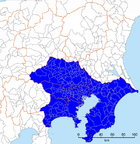 |
| Kantō Major Metropolitan Area (関東大都市圏, Kantō Dai-toshi-ken) | One of the two definitions the uses. Consists of all municipalities that have at least 1.5% of their population aged 15 and above commuting to a designated city (Yokohama, Kawasaki, Sagamihara, Chiba, and Saitama) or the 23 special wards. Before Saitama became a designated city in 2001, the area was called Keihin'yō Major Metropolitan Area (京浜葉大都市圏, Keihin'yō Dai-toshi-ken). Excludes adjacent metropolitan areas of Gunma, Ibaraki, and which are urbanized but have some small towns in between them and Tokyo. Most locally detailed definition, but hard to update without major re-study. | 36,923 (2010)[7] | – | – |  |
| Tokyo Major Metropolitan Area (東京大都市圏, Tōkyō Dai-toshi-ken) | Set of municipalities that are completely or mostly within 50 and 70 kilometres of the Tokyo Metropolitan Government Buildings in Shinjuku. Suburbs tend to extend finger-like along major commuter train routes and density builds along express stops, not in a uniform fashion, and so this definition is of value. | 32,714 (<50 km, 2010), 36,303 (<70 km, 2010)[8] |
– | – |  |
| Purely Administrative | Details | Population 000's(Year) | Area (km2) | Population Density (People/km2) | Map |
|---|---|---|---|---|---|
| Kantō region | Entire national region, includes many rural areas | 40,550 (2000CF) 42,607 (2010CF) 42,945 (2015-12CR) |
32,423.9 | 1,314.1 (2010) |  |
| National Capital Region | According to the National Capital Region Planning Act, very coarse administrative zone, essentially Kantō plus Yamanashi, includes large rural areas. | 41,438 (2000CF) 43,470 (2010CF) 43,785 (2015-12CR) |
36,889.28 | 1,178.4 (2010) |  |
Notes & Sources: All figures issued by Japan Statistics Bureau,[9][10] except for Metro Employment Area, a study by Center for Spatial Information Service, the University of Tokyo. Abbreviations: CF for National Census Final Data (every 5 years by JSB), CR for Civil Registry (compiled by local governments, monthly as per legal requirement), CP for Census Preliminary.
National Capital Region[]
The National Capital Region (首都圏, Shutoken) of Japan refers to the Greater Tokyo Area as defined by the (首都圏整備法, Shutoken-seibi-hō) of 1956, which defines it as "Tokyo and its surrounding area declared by government ordinance."[11] The government ordinance defined it as Tokyo and all six prefectures in the Kantō region plus Yamanashi Prefecture. While this includes all of Greater Tokyo, it also includes sparsely populated mountain areas as well as far-flung Bonin Islands which are administered under Tokyo.
International comparison[]
Using the "One Metropolis Three Prefectures" definition, Tokyo is 13,555.65 square kilometres (5,233.87 sq mi), a similar size to that of Los Angeles County, and almost two-thirds smaller than the Combined Statistical Area of New York City, at 30,671 square kilometres (11,842 sq mi) and 21.9 million people.[citation needed] Other metropolitan areas such as Greater Jakarta are considerably more compact as well as more densely populated than Greater Tokyo.[citation needed]
Metropolitan Area definition ambiguities and issues[]
- The South Kantō region (南関東, Minami Kantō) is a potentially ambiguous term. Informally, it may mean the One Metropolis, Two Prefectures, or the area without Saitama Prefecture. Formally, it may mean the South Kantō Block, which is not the Greater Tokyo Area, but a proportional representation block of the national election, comprising Kanagawa, Chiba, and Yamanashi Prefectures.
- In informal occasions, the term National Capital Region (首都圏, Shuto-ken) often means Greater Tokyo Area. Officially, the term refers to a much larger area, namely the whole Kantō region and Yamanashi Prefecture.
- Tokyo as a metropolis includes some 394 km2
of islands (Izu Islands and Ogasawara Islands), as well as some mountainous areas to the far west (331 km2
), which are officially part of Greater Tokyo, but are wilderness or rustic areas.
Cities[]
(populations listed for those over 300,000)
Cities within Tokyo[]
Tokyo is legally classified as a to (都), which translates as "metropolis", and is treated as one of the forty-seven prefectures of Japan. The metropolis is administered by the Tokyo Metropolitan Government as a whole.

Eastern Tokyo Metropolis[]
Central Tokyo, situated in the eastern portion of Tokyo Metropolis, was once incorporated as Tokyo City, which was dismantled during World War II. Its subdivisions have been reclassified as special wards (特別区, tokubetsu-ku). The twenty three special wards currently have the legal status of cities, with individual mayors and city councils, and they call themselves "cities" in English. However, when listing Japan's largest cities, Tokyo's twenty three wards are often counted as a single city.
Western Tokyo Metropolis[]

Western Tokyo, known as the Tama Area (Tama-chiiki 多摩地域) comprises a number of municipalities, including these suburban cities:
|
|
Cities outside Tokyo[]


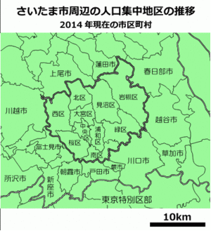
The core cities of the Greater Tokyo Area outside Tokyo Metropolis are:
- Chiba (population 940,000)
- Kawasaki (population 1.36 million)
- Sagamihara (population 730,000)
- Saitama (population 1.19 million)
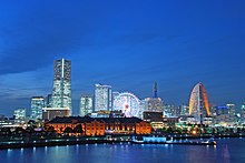
- Yokohama (population 3.62 million)
The other cities in Chiba, Kanagawa and Saitama Prefectures are:
|
|
source: stat.go.jp census 2005
Additional cities[]
In the major metropolitan area (MMA) definition used by the Japanese Statistics Bureau, the following cities in Ibaraki, Tochigi, Gunma, Yamanashi, and Shizuoka Prefectures are included:
Gunma Prefecture[]
- Tatebayashi
Ibaraki Prefecture[]
|
|
|
Shizuoka Prefecture[]
- Atami
Tochigi Prefecture[]
- Oyama
Yamanashi Prefecture[]
- Ōtsuki
- Uenohara
Border areas[]
Tighter definitions for Greater Tokyo do not include adjacent metropolitan areas of Numazu-Mishima (approx. 450,000) to the southwest, Maebashi-Takasaki-Ōta-Ashikaga (approx. 1,500,000 people) on the northwest, and (approx. 1,000,000) to the north. If they are included, Greater Tokyo's population would be around 39 million.Takasaki-Maebashi is included as part of the Tokyo-Yokohama area in the definition of urban areas by Demographia.
Geography[]


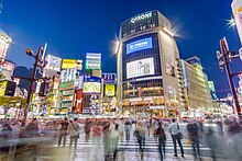
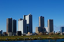
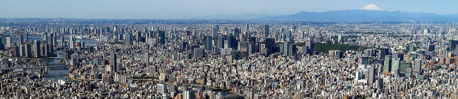
At the centre of the main urban area (approximately the first 10 kilometres (6.2 mi) from Tokyo Station) are the 23 special wards, formerly treated as a single city but now governed as separate municipalities, and containing many major commercial centres such as Shinjuku, Shibuya, Ikebukuro and Ginza. Around the 23 special wards are a multitude of suburban cities which merge seamlessly into each other to form a continuous built up area, circumnavigated by the heavily travelled Route 16 which forms a (broken) loop about 40 kilometres (25 mi) from central Tokyo. Situated along the loop are the major cities of Yokohama (to the south of Tokyo), Hachiōji (to the west), Ōmiya (now part of Saitama City, to the north), and Chiba (to the east). Within the Route 16 loop, the coastline of Tokyo Bay is heavily industrialised, with the Keihin Industrial Area stretching from Tokyo down to Yokohama, and the Keiyō Industrial Zone from Tokyo eastwards to Chiba. Along the periphery of the main urban area are numerous new suburban housing developments such as the Tama New Town. The landscape is relatively flat compared to most of Japan, most of it comprising low hills.
Outside the Route 16 loop the landscape becomes more rural. To the southwest is an area known as Shōnan, which contains various cities and towns along the coast of Sagami Bay, and to the west the area is mountainous.
Many rivers run through the area, the major ones being Arakawa and Tama River.
Demographics[]
| Year | Pop. | ±% |
|---|---|---|
| 1950 | 11,274,641 | — |
| 1955 | 13,712,679 | +21.6% |
| 1960 | 16,678,821 | +21.6% |
| 1965 | 20,284,371 | +21.6% |
| 1970 | 23,297,503 | +14.9% |
| 1975 | 26,614,733 | +14.2% |
| 1980 | 28,548,512 | +7.3% |
| 1985 | 30,303,794 | +6.1% |
| 1990 | 32,530,003 | +7.3% |
| 1995 | 33,586,573 | +3.2% |
| 2000 | 34,449,908 | +2.6% |
| 2005 | 35,621,544 | +3.4% |
| 2010 | 36,859,626 | +3.5% |
| 2015 | 37,256,109 | +1.1% |
| 2020 | 37,393,128 | +0.4% |
| for Tokyo Agglomeration (UN Definition):[12] | ||
Economy[]
Tokyo metropolitan area has the largest city economy in the world and is one of the major global centers of trade and commerce along with New York City and London.
Greater Tokyo Area 2005[]

- 2005 average exchange rate (1 US Dollar = 110.22 Yen)[13]
| Prefecture | Gross Prefecture Product (in billion Yen) |
Gross Prefecture Product (in billion US$) |
|---|---|---|
| Tokyo | ||
| Kanagawa | ||
| Saitama | ||
| Chiba | ||
| Ibaraki | ||
| Tochigi | ||
| Gunma | ||
| Yamanashi | ||
| The One Metropolis and Three Prefectures |
||
| National Capital Region |
Source[14]
GDP (purchasing power parity)[]

The agglomeration of Tokyo is the world's largest economy, with the largest gross metropolitan product at over $2 Trillion purchasing power parity (PPP) in the world according to a study by PricewaterhouseCoopers.[15]
Metropolitan Employment Area[]
| Year | 2010 | 1995 | 1980 |
|---|---|---|---|
| Employed Persons 000's | 16,234 | 16,381 | 12,760 |
| Production (billion US$) | 1,797 | 1,491 | 358 |
| Production Manufacturing (billion US$) | 216 | 476 | 159 |
| Private Capital Stock (billion US$) | 3,618 | 2,631 | 368 |
| Social Overhead Capital (billion US$) | 1,607 | 1,417 | 310 |
| 1 US Dollar (Japanese yen) | 87.780 | 94.060 | 226.741 |
Sources:,[6] Conversion rates – Exchange rates – OECD Data
Transportation[]


Air[]
The Greater Tokyo Area has two major airports, Tokyo International Airport, commonly known as Haneda Airport (once chiefly domestic, now turning international) and Narita International Airport (chiefly international as well). Minor facilities include the Chōfu, Ibaraki Airport, and Honda Airport. Tokyo Heliport serves helicopter traffic, including police, fire, and news. Various military facilities handle air traffic: Naval Air Facility Atsugi (United States Navy and Japan Maritime Self-Defense Force), Yokota Air Base (United States Air Force), and Camp Zama (United States Army).
Rail[]
Greater Tokyo has an extensive railway network comprising high-speed rail, commuter rails, subways, monorails, private lines, trams and others. There are around 136 individual rail lines in the Greater Tokyo Area, and between 1,000 and 1,200 railway stations depending on one's definition of the area, most designed for heavy use, usually long enough to accommodate 10-car (200 metres (660 ft) long) trains. Stations are designed to accommodate hundreds of thousands of passengers at any given time, with miles of connecting tunnels linking vast department stores and corporate offices. Tokyo Station has underground connections that stretch well over 4 kilometres (2.5 mi), and Shinjuku Station has well over 200 exits. Greater Tokyo's Railway Network is easily considered the world's largest in terms of both daily passenger throughput with a daily trips of over 40 million (20 million different passengers) as well as physical extent with approximately 2,578 kilometres (1,602 mi) of track. Shinjuku station is used by an average of 3.34 million people per day, making it the world's busiest train station. Some 57 percent of all Greater Tokyo residents used rail as their primary means of transport in 2001.[16]
JR East and many other carriers crisscross the region with a network of rail lines. The most important carriers include Keihin Kyūkō Electric Railway (Keikyū), Keisei Electric Railway, Keiō Electric Railway, Odakyū Electric Railway, Seibu Railway, Tōbu Railway, and Tōkyū Corporation. In addition to Tokyo's two subway systems — Tokyo Metro and Tokyo Metropolitan Bureau of Transportation (Toei and Toden lines), Yokohama also has two subway lines.
The Tokyo Monorail provides an important shuttle service between Haneda Airport and Hammatsucho station on the Yamanote line.
Other[]
The Shuto Expressway system connects to other national expressways in the capital region.
Tokyo and Yokohama are major commercial seaports, and both the Maritime Self-Defense Force and United States Navy maintain naval bases at Yokosuka.
See also[]
- List of metropolitan areas in Asia by population
- List of metropolitan areas in Japan by population
- National Capital Region (Japan) briefly shows the two definitions of the "Capital Area" (Shuto-ken.)
- Jing-Jin-Ji
- Seoul Capital Area
References[]
- ^ "Megacities in 2014 and 2030". GeoHive. Archived from the original on 2016-01-17. Retrieved 2016-01-09.
- ^ Jump up to: a b United Nations. The World's Cities in 2016 (PDF). Archived (PDF) from the original on 2017-01-12 – via www.un.org.
- ^ Jump up to: a b Liu, Yujing (2019-02-18). "Can China's Greater Bay Area Really Rival the Likes of Tokyo, New York and San Francisco?". South China Morning Post. Archived from the original on 2019-11-01. Retrieved 2019-11-01.
- ^ 第92表/Table 92 (in Japanese and English). Japan Statistics Bureau – Keihin'yō Major Metropolitan Area. Archived from the original (XLS) on 2007-02-10.
- ^ Demographia World Urban Areas: 12th Annual Edition: 2016:04 (PDF), Demographia, 2016, archived from the original (PDF) on 2016-10-13, retrieved 2007-05-10
- ^ Jump up to: a b c "Metropolitan Employment Area (MEA) Data". Center for Spatial Information Science, The University of Tokyo. Archived from the original on 2019-05-02. Retrieved 2016-06-21.
- ^ 第60表 /Table 60 (XLS) (in Japanese and English). 統計局 Tōkeikyoku [Statistics Bureau]. 2010. Archived from the original on 2015-09-24. Retrieved 2015-08-26.
- ^ 第61表 /Table 61 (XLS) (in Japanese and English). 統計局 Tōkeikyoku [Statistics Bureau]. 2010. Archived from the original on 2015-09-24. Retrieved 2015-08-26.
- ^ 第2表 /Table 2 (in Japanese and English). 統計局 Tōkeikyoku [Statistics Bureau]. 2010. Archived from the original (XLS) on 2016-09-12. Retrieved 2018-12-28.
- ^ 第1表 /Table 1 (in Japanese and English). 統計局 Tōkeikyoku [Statistics Bureau]. 2010. Archived from the original (XLS) on 2011-10-04. Retrieved 2018-12-28.
- ^ "Geography of Tokyo". Tokyo Metropolitan Government. Archived from the original on 2011-11-08. Retrieved 2011-10-28.
- ^ "Tokyo Population 2019". World Population Review. Archived from the original on 2019-08-13. Retrieved 2019-08-13.
- ^ International Financial Statistics, International Monetary Fund. "U.S. – Japan Annual Average Exchange Rate". www.mac.doc.gov. Archived from the original on 2009-04-01. Retrieved 2018-12-28.
- ^ "Heisei 19-nendo Kenmin Keizai Keisan" 平成19年度県民経済計算 [2007 Prefectural Accounts]. www.esri.cao.go.jp (in Japanese). Archived from the original on 2010-12-20.
- ^ "City Mayors Reviews the Richest Cities in the World in 2020". www.citymayors.com. Archived from the original on 2019-09-18. Retrieved 2019-02-12.
- ^ Urban Transport Fact Book: Tokyo–Yokohama Suburban Rail Summary (Commuter Rail, Regional Rail) (PDF), 2003, archived (PDF) from the original on 2007-05-07, retrieved 2007-05-15
External links[]
| show Mass transit in the Greater Tokyo Area |
|---|
| show Authority control |
|---|
- Greater Tokyo Area
- Metropolitan areas of Japan