Yokohama Municipal Subway
This article includes a list of general references, but it remains largely unverified because it lacks sufficient corresponding inline citations. (July 2018) |
| Overview | ||
|---|---|---|
| Native name | 横浜市営地下鉄 Yokohama-shiei chikatetsu | |
| Locale | Yokohama, Japan | |
| Transit type | Rapid transit | |
| Number of lines | 2 (Blue & Green) | |
| Number of stations | 42 | |
| Website | www | |
| Operation | ||
| Began operation | December 16, 1972 | |
| Operator(s) | Yokohama City Transportation Bureau | |
| Technical | ||
| System length | 53.4 km (33.2 mi) | |
| Track gauge | 1,435 mm (4 ft 8+1⁄2 in) | |
| ||
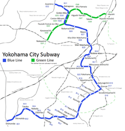
Yokohama Municipal Subway (横浜市営地下鉄, Yokohama-shiei chikatetsu) is the rapid transit network in the city of Yokohama, Japan, south of Tokyo in Kanagawa pref. It is operated by Yokohama City Transportation Bureau as two lines, though three continuous lines exist.


Lines[]

| Symbol | Line | Name | First section opened |
Last ex- tension |
Length km/miles |
Stations |
|---|---|---|---|---|---|---|
| Line 1 | Blue Line | 1972 | 1999 | 19.7 km (12.2 mi) | 17 | |
| Line 3 | 1985 | 1993 | 20.7 km (12.9 mi) | 16[Note 1] | ||
| Line 4 | Green Line | 2008 | - | 13.1 km (8.1 mi) | 10 | |
| Total: | 53.5 km (33.2 mi) | 42 | ||||
The Yokohama Municipal Subway consists of three lines: Line 1, Line 3 and 4. Line 1 and 3 are operated as a single line, nicknamed the Blue Line. Line 4 is nicknamed the Green Line. Upon the addition to the network of this line on March 30, 2008, the Blue Line and Green Line monikers came into official use.
Transfer between the Blue and Green Line is possible at Center-Kita and Center-Minami Stations. Feeder bus services from western Kawasaki City area run to Azamino Station.
The "missing" Line 2 was planned to run from Kanagawa-Shinmachi Station via Yokohama Station to Byobugaura Station. The 11.4 km (7.1 mi) line was previously considered as a bypass line for easing congestion on the Keikyū Main Line, however, the line deemed unnecessary after the Keikyu Line increased its capacity.
Blue Line[]
The Blue Line (Lines 1/3) is operated as an integrated route of 40.4 kilometres (25.1 mi) between Shōnandai Station and Azamino Station. The Blue Line is Japan's second-longest subway line, after the 40.7 km (25.3 mi) Toei Ōedo Line in Tokyo.
In July 2011, a "mobile phone power off area" was set up in each car, and the use of mobile phones is officially banned except in other areas.
Green Line[]
The Green Line (Line 4) opened on March 30, 2008, between Hiyoshi Station and Nakayama Station, operating distance 13.0 km (8.1 mi) (total extension distance 13.1 km (8.1 mi)).
Planned extensions[]
Blue Line[]
An extension of the Blue Line (Line 3) is being studied from Azamino Station to Odakyū Odawara Line's Shin-Yurigaoka Station in Kawasaki City.
Green Line[]
The Green Line was built as part of a larger master plan to construct a circular line in Yokohama. The full line will be a C-shaped line that stretches from Tsurumi Station via Hiyoshi Station, Nakayama Station, Futamatagawa Station, Higashi-Totsuka Station, Kamiōoka Station, and Negishi Station to Motomachi-Chūkagai Station.
Station numbering[]
Numerical designations for the stations on the Blue Line were introduced in 2002, coinciding with Yokohama city hosting the finals of the 2002 FIFA World Cup and the subway's 30th anniversary, starting from Shonandai station (1) to Azamino station (32). With 32 stations on the line and 32 teams in the World Cup, each station was themed after a country. Alphabetical designations were added when the Green Line opened. The Blue Line stations are B01 through B32, while Green Line stations starts from Nakayama Station (G01) to Hiyoshi Station (G10). At two stations—Center-Minami Station and Center-Kita Station—where both lines overlap, a different station number is attached to each route.
Network Map[]

See also[]
- List of metro systems
- Minatomirai Line, a private subway line in Yokohama
- Transport in Greater Tokyo
Notes[]
- ^ Including Kannai Station
External links[]
- Transportation Bureau, City of Yokohama – official website (in English)
- Network map
- Yokohama Municipal Subway Map (in English)
| show Mass transit in the Greater Tokyo Area |
|---|
| show Rapid transit in Asia |
|---|
| Authority control: National libraries |
|---|
- Yokohama Municipal Subway
- Transport in Yokohama