2021 Western Kentucky tornado
| EF4 tornado | |
|---|---|
 Aerial view of EF4 damage in Mayfield, Kentucky, on December 12, one of several towns impacted by the tornado. | |
| Formed | December 10, 2021, 8:54 p.m. CST (UTC−06:00) |
| Duration | 2 hours, 54 minutes |
| Dissipated | December 10, 2021, 11:48 p.m. CST (UTC−06:00) |
| Highest winds |
|
| Max. rating1 | EF4 tornado |
| Fatalities | 57 fatalities (+1 indirect),[1] 515+ injuries[2] |
| Damage | Unknown |
| Areas affected | Western Kentucky, United States |
Part of the tornado outbreak of December 10–11, 2021 1Most severe tornado damage; see Enhanced Fujita scale | |
On December 10, 2021, a violent, long-tracked tornado moved across Western Kentucky, producing severe to catastrophic damage in numerous towns, including Mayfield, Princeton, Dawson Springs, and Bremen.[1] Crossing through eleven counties of the Jackson Purchase and Western Coal Field regions during its lifespan, the tornado was exceptionally long-tracked, traveling 168.5 miles (271.2 km) while at times becoming wrapped in rain. It was the deadliest and longest-tracked tornado in an outbreak that produced numerous strong tornadoes in several states; 57 fatalities were confirmed in the tornado.[1] The second significant tornado in an exceedingly long-tracked tornado family, this tornado began just inside northern Obion County, Tennessee, a few miles after another long-tracked EF4 tornado – which traveled through northeast Arkansas, the Missouri Bootheel, and northwest Tennessee – dissipated in western Obion County.[3]
Meteorological synopsis[]

On December 8, the Storm Prediction Center (SPC) delineated a slight risk of severe weather along much of the Mississippi Valley. Despite the potential for a higher-end severe threat to materialize, forecasters expressed uncertainty regarding the extent of instability, degree of directional wind shear, and late timing of potential storms.[4] The following day, the SPC discussed higher certainty in a corridor of organized severe thunderstorm potential stretching from southeastern Arkansas northeast into southern Indiana, upgrading that region to an enhanced risk.[5]
As an intense upper-level trough progressed across the High Plains, with robust instability and moisture return realized across the Mississippi Valley, the SPC expanded the enhanced risk and introduced a moderate risk area from northeastern Arkansas into southern Illinois on the morning of December 10. Forecasters indicated that atmospheric conditions favored the development of nocturnal supercells capable of producing long-tracked, strong tornadoes.[6]
At 3:00 p.m. CST (21:00 UTC), the SPC issued a tornado watch across the highest risk area (encompassing central and eastern Arkansas, west Tennessee, northwestern Mississippi, southeastern Missouri, and southern portions of Illinois and Indiana), the first of eleven issued over subsequent hours over the middle Mississippi Valley.[7] Initial storms developed across central Arkansas around 2:00 p.m. CST (20:00 UTC), with even weaker activity developing over central Missouri a little over 1+1⁄2 hours later; additional clusters of thunderstorms developed over southwestern Missouri (forming between Bolivar and Carthage, eventually backbuilding into northeastern Oklahoma) and central Arkansas (forming southwest of Hot Springs) between 5:00 and 5:30 p.m. CST (23:00–23:30 UTC).[8] Though this activity lacked much vigor at its onset due to a strong capping inversion,[9] the convective cells began to show organization as they progressed eastward.
One such storm—which formed from the initial mid-afternoon activity near Arkadelphia, Arkansas—matured into a long-lived supercell as it progressed in an unstable, deeply moist, and highly sheared environment;[10] this cell ultimately persisted for 250 miles (400 km) over several hours from eastern Arkansas into Kentucky, producing multiple large and intense tornadoes along its track. The cell began exhibiting surface-based rotation southwest of Searcy, Arkansas around 5:30 p.m. CST (23:30 UTC). At 5:51 p.m. CST, the National Weather Service office in North Little Rock issued the first tornado warning associated with the storm for portions of Jackson, Lawrence, White, and Woodruff counties.[11] One of the first tornadoes associated with the storm, an EF0, touched down in western Poinsett County (near Weiner) around 6:40 p.m. CST; about fifteen minutes later, storm spotters reported a large tornado near Greenfield, prompting a PDS tornado warning for portions of Poinsett, Craighead and Mississippi counties (including areas to the south of Jonesboro).[12]
Doppler radar analysis estimated that the supercell maintained a nearly continuous high-end rotational vorticity signature, averaging at 94 mph (82 kn) for approximately four hours and 20 minutes, among a rarity of thunderstorms (averaging 1.5% of all supercells) that produce mesocyclonic vorticity exceeding such speeds. (The only velocities below said average recorded along the storm track, sustained between 75 and 81 mph [65–70 kn], were observed from 8:44 to 9:01 p.m. CST [02:44–3:01 UTC], as the storm crossed from Obion County, Tennessee into Hickman County, Kentucky). This time frame coincides with the start of the main tornado, following three weak tornadoes that split the two EF4's paths, implying the supercell underwent a mesocyclone re-strengthening phase during this period. During the second, more intense tornado, peak gate-to-gate velocities of 128 mph (111 kn) were recorded at 9:58 p.m. CST (04:58 UTC) over northeastern Marshall County, Kentucky.[13][14][15]
Elsewhere, multiple lines of intense storms, some featuring embedded supercells, developed across the Mississippi Valley region through the overnight hours, contributing to additional strong and long-lived tornadoes.[16][17] By the pre-dawn hours of December 11, a decrease in instability led to a gradual weakening of a line of thunderstorms stretching along the associated cold front from eastern Kentucky southward into central Alabama.[18][19]
The SPC issued a record-setting 43 mesoscale discussions (MCD) throughout the course of the day (12 UTC December 10 to 12 UTC December 11), all of which were associated with the broader storm system: 38 of the MCDs issued were convective discussions relating to the severe thunderstorm activity, and five were non-convective discussions relating to heavy snow associated with the system that concurrently fell throughout much of the Upper Midwest.[20] The National Weather Service (NWS) issued a total of 149 tornado warnings throughout the night across portions of nine states including Arkansas, Tennessee, Missouri, Mississippi, Kentucky, Illinois, and Indiana.[21][15]
Multiple PDS tornado warnings and tornado emergencies were also issued as well in Arkansas, Tennessee, Kentucky, and Missouri. Eight of the tornado warnings issued during the event by the NWS offices in Memphis, Tennessee, and Paducah, Kentucky were tornado emergency declarations, the most issued during the month of December (breaking the previous record of three issued on December 23, 2015).[22][23]
Effects from the system responsible for the outbreak extended into Canada, where the Meteorological Service of Canada issued wind and heavy rainfall warnings for portions of Ontario. However, no tornadoes were expected or reported north of the border.[24]
Tornado summary[]
The tornado began in the community of Woodland Mills in Obion County, Tennessee along Woodland Mills Road at 8:54 p.m. CST (02:54 UTC), produced by the same supercell that had previously produced another long-track tornado that affected northeast Arkansas, the Missouri Bootheel, and northwest Tennessee, near Reelfoot Lake. After dissipation of that tornado in Obion County northeast of Samburg, the supercell produced three weak, brief tornadoes before this one formed several miles to the northeast. The tornado initially caused minor damage to trees and roofs as it moved through the north side of Woodland Mills, crossing Tennessee State Highway 5. After moving northeast a half mile (0.8 km), it crossed the Tennessee–Kentucky state line near the community of State Line in Fulton County, causing additional EF0 tree damage. Farther to the northeast, the tornado reached EF2 strength, tearing roofs off homes, damaging or destroying outbuildings, and damaging irrigation equipment. Soon after, the tornado became violent and directly impacted the small community of Cayce at EF4 intensity, where multiple homes and small businesses were damaged or destroyed, with some that were leveled or swept clean from their foundations. A music venue housed in an old school building was badly damaged, and the Cayce Volunteer Fire Department building was totally destroyed, with the metal beams of the structure being severely twisted, while pieces of heavy machinery were tossed around. Several outbuildings and mobile homes were also obliterated in the Cayce area. One fatality occurred in Cayce, and several other people were injured.[1][25] After moving to the northeast of Cayce, the tornado weakened but still remained strong as it moved through rural areas to the northeast of town at EF3 intensity, destroying barns and a cell tower, and tearing the roof and exterior walls from a house. The tornado moved into Hickman County and appeared to intensify dramatically as it crossed U.S. Route 51, where extreme ground scouring occurred in nearby fields. The tornado scoured multiple trenches into the ground in this area, with all grass and several inches of topsoil removed in the worst affected areas.[26] However, no structures were impacted near U.S. 51, and no rating was applied to the intense scouring. EF3 damage continued past this point as homes and metal truss towers were destroyed. EF2 damage was noted as it tracked into Graves County, closely paralleling Interstate 69 (I-69) and U.S. 45 directly toward the city of Mayfield. A house along Kentucky Route 339 had its roof torn off, and many trees and power poles were downed in this area. The National Weather Service issued a tornado emergency for Mayfield at 9:26 p.m. CST (03:26 UTC) as the now massive wedge tornado approached the town from the southwest.[27] As the tornado entered the southwest side of Mayfield, it regained EF4 intensity, and numerous homes were damaged or destroyed along Cardinal Road, some of which were leveled or swept from their foundations. Trees in this area were debarked and denuded, cars were thrown, and mobile homes were obliterated. EF4 damage continued near the Mayfield Bypass (U.S. 45 Bypass), where Mayfield Consumer Products, a candle factory where approximately 110 employees were working, was flattened to the ground.[28][29] The large metal-framed warehouse building completely collapsed, trapping many employees and resulting in eight deaths and numerous injuries.[30][31][32][33] Allegedly, workers' jobs were threatened if they left the factory between the first and second tornado warnings for the area – a tornado warning had been issued earlier that evening at approximately 5:30 p.m. CST – and then again after the second tornado warning was issued after 9:00 p.m. CST.[34] Several other industrial businesses were also damaged or destroyed near the candle factory, while semi-trucks and other industrial vehicles were thrown and destroyed as well, some of which were left unrecognizable.[25]

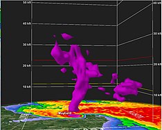
Afterward, the tornado intensified even further, reaching high-end EF4 intensity as it tore directly through the center of town, resulting in widespread, catastrophic damage throughout the historic downtown square of Mayfield.[35][36] Most of the structures in downtown Mayfield were heavily damaged or destroyed, including multiple large, well-built, multi-story brick buildings that completely collapsed. Only large piles of bricks and lumber remained in the hardest-hit portions of the downtown area, and streets were left buried under debris. The large and well-constructed Graves County Courthouse had much of its roof torn off, sustained collapse of its clock tower, and had some of its exterior upper-floor walls knocked down.[37] Several restaurants, an indoor soccer facility, a barber shop, automotive business, gym, bank, movie theatre, health and rehab center, and many other businesses were destroyed in downtown Mayfield. Large metal silos were crumpled and heavily damaged at a granary, and the large Mayfield water tower was toppled to the ground and completely destroyed. The post office, city hall, fire station, and police station were also significantly damaged or destroyed,[28] and the emergency operations center lost the ability to transmit radio communications. Three large churches were destroyed in downtown Mayfield, including the First Presbyterian Church, a large and well-built brick structure that was mostly leveled. The First Christian Church sustained collapse of its domed roof and upper walls, while the First United Methodist Church sustained collapse of its sanctuary, which was constructed with very thick masonry exterior walls. A school bus garage, metal industrial buildings, and apartment buildings also sustained major structural damage or were destroyed in other areas of town. Residential areas of the city were devastated as well, with numerous homes being damaged or destroyed, including many that were leveled or swept from their foundations. Many trees sustained severe denuding and debarking, while cars were thrown hundreds of yards and mangled. Dual polarization radar imagery showed that the tornado had lofted debris up to 30,000 feet (9,100 m) into the air as it impacted the city.[38] 22 people were killed in and around Mayfield, with hundreds more injured, many severely.[39][40][41][25]
After leaving Mayfield, the tornado weakened, producing damage at EF2 to EF3 strength and continuing northeast along I-69. A hangar and some small airplanes were destroyed at the Mayfield Graves County Airport, and multiple homes were badly damaged. A church and a business were damaged nearby, and further weakening occurred further to the northeast, where EF0 to EF1 damage to trees and structures was noted. It then intensified again as it approached and crossed the Marshall County line before moving through the northwestern and northern outskirts of Benton, damaging or destroying many homes, garages, and outbuildings, downing numerous trees and power lines, and flipping RV campers. Most of the damage through this section of Marshall County ranged from EF2 to EF3 in intensity, though a few homes to the southwest of Benton were leveled or swept from their foundations at high-end EF3 strength.[42] Damage continued through the Briensburg community at EF2 intensity, where homes sustained partial to total roof loss, outbuildings were damaged or destroyed, and a metal truss tower collapsed. Past Briensburg, EF3 damage was noted along Lowery Road, where a poorly-anchored home was leveled, and a few other homes sustained EF2 damage along this segment of the path. The tornado reached EF4 intensity as it tore directly through the small community of , located along the western shore of Kentucky Lake. Numerous homes were completely leveled in Cambridge Shores, including multiple large lakeside homes that were flattened or swept away. Numerous large trees were snapped, denuded, and debarked, and vehicles were thrown in this area. A fire department building had its roof torn off, and large metal boat storage buildings were also destroyed. The tornado crossed over Kentucky Lake into Lyon County and moved through the Land Between the Lakes National Recreation Area, mowing down a large swath of trees and snapping power poles before crossing Lake Barkley. After crossing Lake Barkley, the tornado weakened to EF3 strength but continued to cause major damage as it crossed Kentucky Route 93 and Interstate 24 near the eastern shore of the lake, where many additional homes sustained major damage or were destroyed, including several that were leveled or swept from their foundations.[25]


Soon after, it intensified again and crossed into Caldwell County, producing EF4 damage as it impacted the south edge of Princeton, where a tornado emergency was issued.[43] Dozens of homes were destroyed along the southern and southeastern fringes of town, especially at the Princeton Golf and Country Club subdivision, where several houses were leveled or swept away. The University of Kentucky Research Center was destroyed, with metal roof trusses carried hundreds of yards from the structure and wrapped around trees. Cars were thrown from the parking lot into adjacent fields, concrete light pole footings were ripped out of the parking lot, and ground scouring was noted as well.[44] Trees were stripped of their limbs and partially debarked in and around Princeton, barns and farm buildings were obliterated, livestock was killed, and cycloidal markings were left in fields outside of town. Four fatalities occurred in Princeton, along with numerous injuries. The tornado then followed U.S. Route 62, producing EF2 to EF3 damage to homes in the small communities of Lewistown and . Past Midway, the tornado became violent and reached EF4 strength again, producing catastrophic damage as it made a direct hit on the town of Dawson Springs, located along the Caldwell–Hopkins county line. A fourth tornado emergency was in effect for Dawson Springs and St. Charles as the storm moved through the area. Residential areas in the northern part of Dawson Springs were devastated, with entire blocks of homes destroyed, many of which were leveled or swept from their foundations. Cars were thrown, copious amounts of structural debris was strewn in all directions, countless trees were shredded and debarked, and only rubble remained in the hardest-hit neighborhoods. The Dawson Village apartment complex was totally destroyed, and several two-story brick apartment buildings sustained EF4 damage there, being largely reduced to rubble with only a few first floor interior walls left intact. Numerous vehicles were thrown into piles in the parking lot of the complex. Several duplexes were destroyed at Clarkdale Court, including one that was leveled with only a pile of debris remaining. An American Legion post and a car wash were flattened, while a church and a medical clinic sustained major damage. Some logistics facilities and warehouses were leveled in an industrial park as the tornado exited town, and several metal self-storage unit buildings and large garages were obliterated nearby.[45] 14 people were killed in the Dawson Springs area, and many others were injured. A mother and her three children survived with relatively minor injuries by hanging on to a mattress as they were thrown 200 feet through the air into a field after the tornado swept their Dawson Springs home from its foundation.[36][25][46] A photograph taken in 1942 was lofted from a destroyed house in Dawson Springs and transported for almost 130 miles (210 km) by the intense tornadic updrafts, eventually being found in New Albany, Indiana.[47]

Weakening slightly to high-end EF3 strength but continuing to cause major damage, the tornado tracked to the northeast beyond Dawson Springs, passing north of Ilsley and through the rural community of . Farm outbuildings and mobile homes were demolished, and multiple houses sustained major damage or were destroyed, some of which of which were flattened. Additional high-end EF3 damage occurred and another tornado emergency was issued as it moved through Barnsley, just south of Earlington.[48] Almost every house in the small community was damaged or destroyed, including some that were leveled, though they were not well-constructed. A CSX freight line train was derailed as the tornado struck Barnsley, and 25 multi-ton freight cars were derailed, several of which were thrown from the tracks, including one that was tossed into a house.[49][50] Thousands of large trees were mowed down, and vehicles were flipped as well. Past Barnsley, the tornado passed through an unpopulated swampy area, where more large trees were snapped or uprooted, and damage was rated EF2. Continuing into northern Muhlenberg County, yet another tornado emergency was issued for the community of Bremen as the tornado approached from the southwest. It abruptly intensified to high-end EF4 strength as it crossed and paralleled Kentucky Route 175 through the north side of town. Many homes were destroyed along this portion of the path, including several that were obliterated and swept away, with little debris remaining. Large trees sustained severe denuding and debarking, grass was scoured from the ground, and vehicles were thrown through the air and severely mangled. Some of the worst damage in Bremen occurred along Bethlehem Cemetery Road, where a row of four homes were obliterated, with debris scattered and wind-rowed long distances through fields across the street. Concrete floor slabs were torn from the foundation of one home and shattered, while the paved driveway of another residence was cracked and scoured. Houses that were farther away from the center of the damage path sustained roof and exterior wall loss, while mobile homes, barns, garages, and outbuildings were also destroyed. Bethlehem Baptist Church had one of its brick exterior walls blown out and was shifted off of its foundation slightly, while Church Street General Baptist Church lost much of its roof.[51][52] A total of 11 people were killed in and around Bremen, and others were injured.[53] Among the fatalities was District Judge Brian Crick, who represented Muhlenberg and McLean counties, as confirmed in a statement from the Supreme Court of Kentucky on December 11.[54] Some weakening occurred, but significant damage continued after the tornado exited Bremen and crossed U.S. Route 431, where some homes and mobile homes were damaged or destroyed, and hundreds of large trees were snapped and denuded. Damage in this area was rated EF2 to low-end EF3.[25]

Passing near the Muhlenberg–McLean county line, the tornado weakened substantially as it crossed into Ohio County at 11:10 p.m. (05:10 UTC), producing EF1 damage as it traversed rugged, hilly terrain to the west of Centertown. It moved through an abandoned coal strip mine, overturning a large section of a coal conveyor belt, snapping many trees, and downing power poles. A few farm outbuildings were also damaged or destroyed in this area. It became strong again north of Centertown, producing EF2 damage as multiple homes and outbuildings were damaged or destroyed, including a well-built house that had much of its roof torn off and sustained collapse of an exterior wall. Five large chicken houses were destroyed, and hundreds of large hardwood trees were snapped and uprooted along a quarter-mile wide swath along this section of the path. Weakening back to EF1 intensity, the tornado downed trees along Carter Ferry Road and Mud College Road. The tornado entered a flatter area to the west of Hartford and began to intensify once more, and large steel power poles were bent over or broken along Johnson School Road, earning an EF3 rating. It crossed U.S. 231, Interstate 165, and Kentucky Route 69 near Hartford, along with the Rough River twice.[1] Homes and businesses sustained significant EF3 damage in this area, and two tractor-trailers were lifted and thrown 40 yards (37 m), with one of the cabs being badly mangled. Large barns and garages were completely demolished, and a small brick office structure was destroyed, along with homes, very large silos, and a fertilizer storage facility.[25][55] The last area of EF3-strength damage occurred along KY 69 and Utley Drive northeast of Hartford, where a poorly-anchored block-foundation home was swept away and completely destroyed, and other houses nearby sustained total loss of their roofs and exterior walls. Two anchored mobile homes were also swept away and destroyed, with their frames tossed and bent, one of which was thrown 100 yards (91 m). An RV camper was thrown 30 yards (27 m) in this area as well, landing upside down, while tractors and large hay bales were also thrown considerable distances.[25][55] Damage of up to high-end EF2 intensity occurred beyond this point as the tornado crossed Humble Valley Road, Halls Creek Road, and Mount Vernon Road before passing north of Olaton. Homes were significantly damaged, barns and mobile homes were destroyed, a cow was killed, and thousands of large hardwood trees were downed. The tornado paralleled the Ohio–Grayson county line, and very briefly crossed a bend in the Rough River into Grayson County. Hundreds of trees were downed along Cane Ford Road, and an abandoned trailer home was destroyed. The tornado then crossed Kentucky Route 54, where the last area of EF2 damage occurred, as a frail home was destroyed and left with only a few walls standing, and large trees were snapped, one of which fell on and destroyed a car. Some outbuildings were also damaged or destroyed in this area. Entering Breckinridge County at EF1 intensity, it paralleled the Breckinridge–Grayson county line and passed northwest of Falls of Rough. Hundreds of trees were downed in this area, and a couple of structures sustained minor damage. It downed power lines as it crossed Kentucky Route 79 at EF0 strength, where it damaged a large boat storage facility and scattered debris 300 yards (270 m) to the northeast, across the runway of a small airport. Minor tree damage occurred before the tornado dissipated near Park Drive in Grayson County at 11:48 p.m. CST (5:48 UTC) as it entered Rough River Dam State Resort Park near Rough River Lake, approximately four miles (6.4 km) west of McDaniels.[25]
The tornado was on the ground for nearly three hours, tracking 168.53 miles (271.22 km) from Woodland Mills to Rough River Dam State Resort Park.[25][55] The path was the ninth longest in recorded history.[56] It was rated high-end EF4, with an estimated peak wind speed of 190 mph (310 km/h). With a confirmed death toll of 57, it was the deadliest single tornado in the United States since the Joplin, Missouri tornado on May 22, 2011, ten years earlier. A 58th fatality was the result of a heart attack while clearing debris and is listed as indirect.[57]
Aftermath[]
Recovery efforts were underway as disaster-aid and humanitarian groups, such as the American Red Cross, The Salvation Army, and World Vision collected donations and travelled to or shipped relief items to affected areas to provide aid after the tornado.[58]
On December 11, President Joe Biden approved a federal emergency disaster declaration for the state of Kentucky.[58] Earlier that day, Governor Andy Beshear declared a state of emergency for parts of western Kentucky.[59] Beshear also announced the creation of a tornado relief fund and asked people to donate blood, as donated blood was running low throughout the pandemic.[58] On December 15, Mayor of Mayfield Kathy Stewart O’Nan said that recovery efforts would continue.[60]
Accusations that factory management prohibited workers from leaving the candle factory before the tornado struck were reported on December 13.[61][62] Workers said they were told by management that "if you leave, you’re more than likely to be fired."[63] On December 17, it was reported that multiple workers at the candle factory filed a lawsuit against Mayfield Consumer Products in state court, seeking compensation and punitive damages. The lawsuit alleges that the factory had up to three and a half hours to let workers leave as safety precautions and did not, and the company showed a "flagrant indifference to the rights of workers" and violated the Kentucky occupational safety and health workplace standards, by refusing evacuations.[64]
See also[]
- Tornado outbreak of December 10–11, 2021
- Weather of 2021
- Tornadoes of 2021
- Tri-State tornado
- List of North American tornadoes and tornado outbreaks
- Tornado intensity and damage
- Tornado records
References[]
- ^ a b c d e f "Dec 10–11, 2021 Tornado Event". National Weather Service Forecast Office in Paducah, Kentucky. January 25, 2022. Archived from the original on December 12, 2021. Retrieved January 31, 2022.
- ^ "Storm Events Database - Search Results". www.ncdc.noaa.gov. National Centers for Environmental Information. Retrieved March 20, 2022.
- ^ "December 10-11, 2021 Tornado Outbreak". National Weather Service Forecast Office in Memphis, Tennessee. December 15, 2021. Archived from the original on December 20, 2021. Retrieved December 20, 2021.
- ^ Aaron Gleason (December 8, 2021). "Dec 8, 2021 0830 UTC Day 3 Severe Thunderstorm Outlook". Storm Prediction Center. Archived from the original on December 8, 2021. Retrieved December 11, 2021.
- ^ Aaron Gleason (December 9, 2021). "Dec 9, 2021 0700 UTC Day 2 Convective Outlook". Storm Prediction Center. Archived from the original on December 11, 2021. Retrieved December 11, 2021.
- ^ Rich Thompson; Matt Mosier (December 10, 2021). "Dec 10, 2021 1630 UTC Day 1 Convective Outlook". Storm Prediction Center. Archived from the original on December 13, 2021. Retrieved December 11, 2021.
- ^ Rich Thompson (December 10, 2021). "Tornado Watch 552". Storm Prediction Center. Archived from the original on December 10, 2021. Retrieved December 11, 2021.
- ^ Brian Squitieri; Jeremy Grams (December 10, 2021). "Mesoscale Discussion 1984". Storm Prediction Center. Archived from the original on December 12, 2021. Retrieved December 12, 2021.
- ^ Evan Bentley (December 10, 2021). "Mesoscale Discussion 1982". Storm Prediction Center. Archived from the original on December 10, 2021. Retrieved December 12, 2021.
- ^ Brian Squitieri; Jeremy Grams (December 10, 2021). "Mesoscale Discussion 1986". Storm Prediction Center. Archived from the original on December 11, 2021. Retrieved December 12, 2021.
- ^ "Tornado Warning (AR) #1". National Weather Service Little Rock, Arkansas. December 10, 2021. Archived from the original on September 1, 2020. Retrieved December 12, 2021 – via Iowa Environmental Mesonet.
- ^ "Tornado Warning (AR) #2". National Weather Service Little Rock, Arkansas. December 10, 2021. Archived from the original on September 1, 2020. Retrieved December 12, 2021 – via Iowa Environmental Mesonet.
- ^ Dylan Moriarty; Bonnie Berkowitz; Zach Levitt (December 11, 2021). "Deadly path: How tornadoes ripped through states". The Washington Post. Archived from the original on December 11, 2021. Retrieved December 12, 2021.
- ^ Jason Samenow (December 11, 2021). "December tornadoes aren't rare, but Friday's outbreak was something totally different". The Washington Post. Nash Holdings LLC. Archived from the original on December 12, 2021. Retrieved December 12, 2021.
- ^ a b "The record-breaking tornadoes that swept the United States, by the numbers". The Washington Post. Nash Holdings LLC. December 13, 2021. Archived from the original on December 13, 2021. Retrieved December 14, 2021.
- ^ Evan Bentley (December 10, 2021). "Mesoscale Discussion 1988". Storm Prediction Center. Archived from the original on December 11, 2021. Retrieved December 12, 2021.
- ^ Brian Squitieri; Jeremy Grams (December 10, 2021). "Mesoscale Discussion 1998". Storm Prediction Center. Archived from the original on December 11, 2021. Retrieved December 12, 2021.
- ^ Elizabeth Leitman (December 11, 2021). "Mesoscale Discussion 2018". Storm Prediction Center. Archived from the original on December 12, 2021. Retrieved December 12, 2021.
- ^ Elizabeth Leitman (December 11, 2021). "Mesoscale Discussion 2020". Storm Prediction Center. Archived from the original on December 11, 2021. Retrieved December 12, 2021.
- ^ Jared Guyer and Matt Elliott (December 12, 2021). "An overview of the Mesoscale Discussions". twitter.com. Archived from the original on December 13, 2021. Retrieved December 12, 2021.
- ^ Jason Samenow; Ian Livingston; Jacob Feuerstein (December 11, 2021). "How Friday night's rare and deadly December tornado outbreak unfolded". The Washington Post. Nash Holdings LLC. Archived from the original on December 12, 2021. Retrieved December 12, 2021 – via The Seattle Times.
- ^ "Many trapped, two dead as tornado hits nursing home in Arkansas -media". reuters.com. December 11, 2021. Archived from the original on December 11, 2021. Retrieved December 11, 2021.
- ^ Kathryn Prociv; Nicole Acevedo (December 11, 2021). "'Quad-State Tornado' crossed four states in four hours, a rare December tornado". NBC News. Archived from the original on December 12, 2021. Retrieved December 12, 2021.
- ^ Kabi Moulitharan (December 11, 2021). "Environment Canada issues wind warning for most of southern Ontario". Global News. Corus Entertainment. Archived from the original on December 11, 2021. Retrieved December 16, 2021.
- ^ a b c d e f g h i j "Damage Assessment Toolkit". National Weather Service. Archived from the original on April 23, 2020. Retrieved December 16, 2021.
- ^ Emfinger, Brian (December 20, 2021). "Some ground scouring along Hwy 51 between Clinton and Fulton, KY". twitter.com. Twitter. Archived from the original on January 4, 2022. Retrieved January 4, 2022.
Some ground scouring along Hwy 51 between Clinton and Fulton, KY
- ^ "Tornado Emergency For Mayfield". Iowa Environmental Mesonet. National Weather Service Forecast Office in Paducah, Kentucky. December 10, 2021. Archived from the original on September 1, 2020. Retrieved December 11, 2021.
- ^ a b "At least 70 feared dead in Kentucky as tornadoes rip through swaths of U.S." NBC News. Archived from the original on December 12, 2021. Retrieved December 12, 2021.
- ^ Brinkmann, Heather (December 11, 2021). "Catastrophic tornado damage reported in Mayfield, Kentucky". Fox Weather. Archived from the original on December 11, 2021. Retrieved December 11, 2021.
- ^ "Thousands without heat, water after tornadoes kill dozens". AP News. December 13, 2021. Archived from the original on December 13, 2021. Retrieved December 13, 2021.
- ^ D'Angelo, Bob; Seiger, Theresa; Dreier, Natalie (December 13, 2021). "Kentucky tornadoes: 8 confirmed dead at candle factory, 8 still missing". KOKI-TV. Archived from the original on December 11, 2021. Retrieved December 13, 2021.
- ^ "At least 70 feared dead in Kentucky as tornadoes rip through swaths of U.S." NBC News. Archived from the original on December 12, 2021. Retrieved December 12, 2021.
- ^ Brinkmann, Heather (December 11, 2021). "Catastrophic tornado damage reported in Mayfield, Kentucky". Fox Weather. Archived from the original on December 11, 2021. Retrieved December 11, 2021.
- ^ "Factory workers threatened with firing if they left before tornado, employees say". NBC News. Archived from the original on December 13, 2021. Retrieved December 13, 2021.
- ^ "Deadly tornadoes, storms strike US; roof collapse at Amazon". AP NEWS. December 11, 2021. Archived from the original on December 11, 2021. Retrieved December 11, 2021.
- ^ a b Krauth, Olivia. "Kentucky tornado death toll: 50 people have been confirmed dead after storms by officials". The Courier-Journal. Archived from the original on December 13, 2021. Retrieved December 12, 2021.
- ^ Bogard, Catlin (December 11, 2021). "Severe tornado hits Mayfield, Kentucky, destroying buildings; Police say loss of life 'expected'". WTVF. Archived from the original on December 11, 2021. Retrieved December 11, 2021.
- ^ Nathan Santo Domingo. "Usually, we can call these "hail spikes." It's a radar artifact that is usually caused by very large hail. In this instance, however, this is a "debris spike" due to a massive tornado lofting large objects high into the air. Unreal... #kywx". Twitter. Archived from the original on December 11, 2021. Retrieved December 12, 2021.
- ^ Ward, Karla (December 11, 2021). "'Multiple fatalities' in Kentucky after tornado outbreak". Lexington Herald Ledger. Archived from the original on December 13, 2021. Retrieved December 11, 2021.
- ^ "Business destroyed by Mayfield tornado". foxlexington.com. Fox News. December 13, 2021. Archived from the original on January 4, 2022. Retrieved January 4, 2022.
- ^ "Kentucky tornado updates: Death toll now 76; another Mayfield candle factory worker dies". wlky.com. WLKY. December 22, 2021. Archived from the original on January 4, 2022. Retrieved January 4, 2022.
- ^ "Tornado Emergency For Benton". Iowa Environmental Mesonet. National Weather Service Forecast Office in Paducah, Kentucky. December 10, 2021. Archived from the original on September 1, 2020. Retrieved December 11, 2021.
- ^ "Tornado Emergency For Princeton, KY". Iowa Environmental Mesonet. National Weather Service Forecast Office in Paducah, Kentucky. December 10, 2021. Archived from the original on September 1, 2020. Retrieved December 11, 2021.
- ^ Jackson, Chris (December 12, 2021). "We're out here at the UK Research Center in Princeton and this is the most intense tornado damage I've ever seen in my life". twitter.com. Twitter. Archived from the original on December 13, 2021. Retrieved January 5, 2021.
- ^ "Tornado Emergency For Dawson Springs and St. Charles". Iowa Environmental Mesonet. National Weather Service Forecast Office in Paducah, Kentucky. December 10, 2021. Archived from the original on September 1, 2020. Retrieved December 11, 2021.
- ^ Lavandera, Ed (December 13, 2021). "Dawson Springs mother clutched her 2 kids in bed when the storm lifted her mattress into the air". cnn.com. CNN. Archived from the original on January 5, 2022. Retrieved January 5, 2022.
- ^ "Photo from tornado-damaged home lands almost 130 miles away". The Seattle Times. December 12, 2021. Archived from the original on December 12, 2021. Retrieved December 13, 2021.
- ^ "Tornado Emergency For Earlington and Afton, KY". Iowa Environmental Mesonet. National Weather Service Forecast Office in Paducah, Kentucky. December 10, 2021. Archived from the original on September 1, 2020. Retrieved December 11, 2021.
- ^ "Kentucky: Scores feared dead after tornadoes devastate US state". GB News. December 11, 2021. Archived from the original on December 11, 2021. Retrieved December 11, 2021.
- ^ Wilson, Mark (December 11, 2021). "Kentucky tornado derails a train in Hopkins County; one car lands on home". Evansville Courier & Press. Archived from the original on December 12, 2021. Retrieved December 13, 2021.
- ^ "Before and after photos from a newly constructed home in Bremen. The concrete foundation was scoured away. Photos by Jeff Stevens on facebook". twitter.com. Twitter. December 14, 2021. Archived from the original on January 6, 2022. Retrieved January 5, 2022.
- ^ Brewer, Simon (December 14, 2021). "Tragic tornado damage to neighborhood on NW side of Bremen, KY". twitter.com. Twitter. Archived from the original on January 6, 2022. Retrieved January 5, 2022.
new/thick driveway buckled
- ^ "Tornado Emergency For Bremen, KY". Iowa Environmental Mesonet. National Weather Service Forecast Office in Paducah, Kentucky. December 10, 2021. Archived from the original on September 1, 2020. Retrieved December 11, 2021.
- ^ WLKY Digital Team (December 11, 2021). "Kentucky district judge confirmed dead in tornado outbreak". WLKY. Archived from the original on December 12, 2021. Retrieved December 12, 2021.
- ^ a b c "NWS Damage Survey for 12/10/2021 Tornado Event – Ohio/Breckinridge/Grayson County Kentucky Tornado". Iowa Environmental Mesonet. National Weather Service Weather Forecast Office in Louisville, Kentucky. December 15, 2021. Archived from the original on December 15, 2021. Retrieved December 16, 2021.
- ^ "2021 Severe Weather: Year-In-Review". Storm Prediction Center. National Weather Service. Archived from the original on January 14, 2022. Retrieved January 14, 2022.
- ^ Kentucky Event Report: EF4 Tornado (Report). National Centers for Environmental Information. National Weather Service in Paducah, Kentucky. 2021. Retrieved March 19, 2022.
- ^ a b c "Kentucky hardest hit as storms leave dozens dead in 5 states". AP NEWS. December 11, 2021. Archived from the original on December 11, 2021. Retrieved December 12, 2021.
- ^ Hatter, Evan (December 11, 2021). "Governor Andy Beshear declares a State of Emergency after Western Kentucky tornadoes". WYMT-TV. Archived from the original on December 11, 2021. Retrieved December 11, 2021.
- ^ Schnell, Mychael (December 12, 2021). "Mayfield, Ky., mayor: 'There's always hope. We hope for a miracle'". TheHill. Archived from the original on December 15, 2021. Retrieved December 15, 2021.
- ^ "Factory workers threatened with firing if they left before tornado, employees say". NBC News. Archived from the original on December 13, 2021. Retrieved December 14, 2021.
- ^ "Kentucky candle factory bosses threatened to fire those who fled tornado, say workers". the Guardian. December 14, 2021. Archived from the original on December 14, 2021. Retrieved December 14, 2021.
- ^ Dodds, Io (December 15, 2021). "Kentucky tornado: Candle factory workers threatened with being fired if they fled approaching storm, report says". The Independent. Archived from the original on December 20, 2021. Retrieved December 25, 2021.
- ^ Norman, Greg (December 17, 2021). "Kentucky tornado aftermath: Candle factory workers file lawsuit as state death toll rises to 76". Fox News. Archived from the original on December 17, 2021. Retrieved December 17, 2021.
- Tornadoes of 2021
- 2021 in Kentucky
- 2021 natural disasters in the United States
- December 2021 events in the United States
- Tornadoes in Kentucky
- F4 tornadoes