A449 road
This article includes a list of general references, but it remains largely unverified because it lacks sufficient corresponding inline citations. (August 2010) |
 | |
|---|---|
 | |
 | |
| Route information | |
| Maintained by Highways England, English local authorities and South Wales Trunk Road Agency | |
| Length | 104 mi (167 km) |
| Major junctions | |
| North end | Stafford |
A34 A5
A38 A40 | |
| South end | Newport |
| Location | |
| Primary destinations | Wolverhampton Kidderminster Worcester Ledbury Ross-on-Wye |
| Road network | |
| |
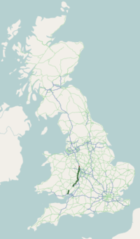
The A449 is a major road in the United Kingdom. It runs north from junction 24 of the M4 motorway at Newport in South Wales to Stafford in Staffordshire.

The southern section of the road, between Ross on Wye and Newport forms part of the trunk route from the English Midlands to South Wales, avoiding the Severn Bridge
Route[]
Newport - Ross-on-Wye[]
The A449 starts on the M4 at the Coldra Interchange (J24) in Newport and is dual carriageway all the way to Raglan. The section from the A40 junction at Raglan to the A472 junction at Usk, known as the New Midlands Road, was one of the first sections to be dualled, opening on 16 October 1970. A special postmark dated 8 December 1972 was produced showing the opening of the A449 by The Secretary of State for Wales. Between Raglan and Ross-on-Wye the A449 is concurrent with the A40.
Ross-on-Wye - Worcester[]
The road becomes quite twisty on departing Ross-on-Wye, but straightens out a little before arriving at Ledbury. The road turns northwards upon crossing into Worcestershire at Little Malvern and skirts the eastern slopes of the Malvern Hills through the town of Great Malvern. It then crosses Worcester's ring road, the A4440, at a roundabout near Powick.
Worcester - Wolverhampton[]
North of Worcester, a spur road of the same number heads towards the M5 Junction 6, while the main route continues towards Kidderminster, concurrent with the A442. Between Claines and Hartlebury the A449 is once again dual carriageway, but much tinkering has left the road with a single lane each way and 50 miles per hour (80 km/h) speed restriction. The road becomes urban again while passing through Kidderminster. It then heads north into Staffordshire, passing between Kinver and Stourbridge and crossing the A458 at Stourton. The A491 meets it just north of Kingswinford. Continuing northwards, it passes Wombourne (becoming dual carriageway once more) being joined by the A463 before turning sharply north-east into the outskirts of Wolverhampton and meeting the Ring Road.
Wolverhampton - Stafford[]
The road resumes its journey northwards, passing Molineux Stadium (home of Wolverhampton Wanderers F.C.) and leaving the city just south of Junction 2 of the M54. It originally ran through the centre of Wolverhampton until the 1970s, when all roads within the new ring road were declassified. Around the same time, the section of Waterloo Road on which Molineux Stadium stands was declassified and the A459 Upper Stafford Street and Lower Stafford Street became part of the A449.
From there it forms part of the link between the M54 and the M6 North. It crosses the A5 at the Gailey Roundabout near the village of Gailey, a short distance west of M6 Junction 12, at which point it reverts to a single carriageway. It passes through Penkridge before crossing the M6 at Junction 13, reaching its terminus at its junction with the A34 in Stafford.
Originally turnpiked under an Act of 1760, the Wolverhampton-Stafford road was part of the historic London-Liverpool coach route. Notoriously narrow in the 19th century, much of it was turned into dual carriageway between the world wars. The Gailey Roundabout was improved in 1929 and again in 1937, removing parts of the churchyard and the historic Spread Eagle Inn (although the latter was replaced by a new building). Widening at Penkridge between 1932 and 1934 reshaped the western part of the town, resulting in the demolition of many ancient buildings.[1] The dual carriageway between Wolverhampton and Gailey was constructed between 1936 and 1939.[2] This section of the road was featured in Citizen Khan episode "Alia's University".
Former Routes[]
- The original routing of the road was from Bromsgrove - Stourbridge – Wolverhampton – Stafford
- The villages of Hartlebury and Ombersley have been bypassed
- Part of Ledbury is now bypassed
- Between Raglan and Newport the A449 used to run through the towns of Usk and Caerleon, along a now mostly unclassified road to the west, terminating at junction 25 of the M4
Water Crossings[]
- River Trothy, Monmouth
- River Monnow, Monmouth
- River Wye, Ross-on-Wye
- River Leadon, Ledbury
- River Severn, Worcester
- Stourbridge Canal, Stourton
- River Stour, Kinver
- Wom Brook, Wombourne
- Birmingham Canal, Wolverhampton
- Staffordshire and Worcestershire Canal, Coven
- River Penk, Penkridge
See also[]
References[]
External links[]
| Wikimedia Commons has media related to A449 road (Great Britain). |
A roads in Zone 4 of the Great Britain road numbering scheme | ||
|---|---|---|
| ||
| ||
| Managed by the North and Mid Wales Trunk Road Agent |
|  |
|---|---|---|
| Managed by the South Wales Trunk Road Agent |
| |
| Related topics and further information | ||
Transport in Monmouthshire | ||
|---|---|---|
| Road |
|  |
| Bus |
| |
| National Cycle Network |
| |
| Railway lines | ||
| Railway stations |
| |
| Waterways |
| |
Transport in Newport | ||
|---|---|---|
| Road |
|  |
| Bus |
| |
| Railway lines |
| |
| Railway stations | ||
| Cycling |
| |
| Walking |
| |
| Waterways |
| |
| Sea | ||
| Transporter bridge |
| |
| Road |
| ||||||||||||||
|---|---|---|---|---|---|---|---|---|---|---|---|---|---|---|---|
| Rail |
| ||||||||||||||
| Buses |
| ||||||||||||||
| Waterways |
| ||||||||||||||
| Footpaths |
| ||||||||||||||
| Cycle paths |
| ||||||||||||||
Coordinates: 52°14′24″N 2°13′38″W / 52.23989°N 2.22731°W

- Roads in England
- Roads in Wales
- Transport in Herefordshire
- Transport in Monmouthshire
- Transport in Newport, Wales
- Transport in Staffordshire
- Roads in Worcestershire
- Transport in Worcester, England
- Malvern, Worcestershire
- Transport in Wolverhampton