Aba Segud Airport
Aba Segud Airport Jimma Airport | |||||||||||
|---|---|---|---|---|---|---|---|---|---|---|---|
| Summary | |||||||||||
| Airport type | Public | ||||||||||
| Owner | Ethiopian Civil Aviation Authority | ||||||||||
| Operator | Ethiopian Airports Enterprise | ||||||||||
| Serves | Jimma, Ethiopia | ||||||||||
| Elevation AMSL | 5,587 ft / 1,703 m | ||||||||||
| Coordinates | 07°39′57″N 036°48′59″E / 7.66583°N 36.81639°ECoordinates: 07°39′57″N 036°48′59″E / 7.66583°N 36.81639°E | ||||||||||
| Map | |||||||||||
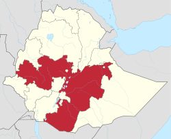 HAJM Location in Ethiopia (Oromia region in red) | |||||||||||
| Runways | |||||||||||
| |||||||||||

Aba Segud Airport (IATA: JIM, ICAO: HAJM), also known as Jimma Airport,[4] is an airport serving Jimma,[2] a city in the Oromia Region of Ethiopia. The airport is located 2.5 km (1.6 miles) southwest of the city.[4]
Facilities[]
The Aba Segud Airport sits at an elevation of 5,587 feet (1,703 m) above mean sea level. It has one runway designated 13/31, with an asphalt surface measuring 3,300 by 50 metres (10,827 ft × 164 ft).[2]
Airlines and destinations[]
| Airlines | Destinations |
|---|---|
| Ethiopian Airlines[5] | Addis Ababa, Dembidolo |
References[]
- ^ Google Maps - Jimma
- ^ a b c Airport information for HAJM[permanent dead link] from DAFIF (effective October 2006)
- ^ Airport information for JIM at Great Circle Mapper. Source: DAFIF (effective October 2006).
- ^ a b "Jimma Airport". Ethiopian Airports Enterprise. Archived from the original on 4 June 2012.CS1 maint: bot: original URL status unknown (link)
- ^ "Domestic routes". Ethiopian Airlines.
External links[]
Categories:
- Airports in Ethiopia
- Oromia Region