Achanalt railway station
 | |
| Location | Achanalt, Highland Scotland |
| Coordinates | 57°36′35″N 4°54′49″W / 57.6096°N 4.9135°WCoordinates: 57°36′35″N 4°54′49″W / 57.6096°N 4.9135°W |
| Grid reference | NH260614 |
| Managed by | Abellio ScotRail |
| Platforms | 1 |
| Other information | |
| Station code | AAT |
| History | |
| Original company | Dingwall and Skye Railway |
| Pre-grouping | Highland Railway |
| Post-grouping | LMSR |
| Key dates | |
| 19 August 1870[2] | Station opened |
| Passengers | |
| 2016/17 | |
| 2017/18 | |
| 2018/19 | |
| 2019/20 | |
| 2020/21 | |
| Location | |
 | |
| Notes | |
Passenger statistics from the Office of Rail and Road | |

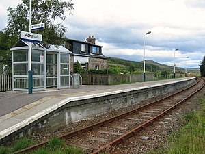
Achanalt railway station is a geographically remote railway station on the Kyle of Lochalsh Line, serving the village of Achanalt in the north of Scotland.
The station is 21 miles 34 chains (34.5 km) from Dingwall, and has a single platform which is long enough for a three-coach train.[3]
History[]
The station was opened by the Dingwall and Skye Railway, but operated from the outset by the Highland Railway. Taken into the London, Midland and Scottish Railway during the Grouping of 1923, the line then passed on to the Scottish Region of British Railways on nationalisation in 1948.
When Sectorisation was introduced by British Rail, the station became part of ScotRail until the Privatisation of British Rail.
Service[]
Four trains each way call (on request) on weekdays/Saturdays and one each way all year on Sundays, plus a second from May to late September only.[4]
| Preceding station | Following station | |||
|---|---|---|---|---|
| Lochluichart | Abellio ScotRail Kyle of Lochalsh Line |
Achnasheen | ||
| Historical railways | ||||
Line open; Station closed |
Highland Railway Dingwall and Skye Railway |
Achnasheen Line and Station open | ||
References[]
Notes[]
- ^ Brailsford 2017, Gaelic/English Station Index.
- ^ Butt (1995)
- ^ Brailsford 2017, map 22F.
- ^ GB eNRT May 2016 Edition, Table 239
Sources[]
- Brailsford, Martyn, ed. (December 2017) [1987]. Railway Track Diagrams 1: Scotland & Isle of Man (6th ed.). Frome: Trackmaps. ISBN 978-0-9549866-9-8.
- Butt, R. V. J. (1995). The Directory of Railway Stations: details every public and private passenger station, halt, platform and stopping place, past and present (1st ed.). Sparkford: Patrick Stephens Ltd. ISBN 978-1-85260-508-7. OCLC 60251199.
- Jowett, Alan (March 1989). Jowett's Railway Atlas of Great Britain and Ireland: From Pre-Grouping to the Present Day (1st ed.). Sparkford: Patrick Stephens Ltd. ISBN 978-1-85260-086-0. OCLC 22311137.
- Jowett, Alan (2000). Jowett's Nationalised Railway Atlas (1st ed.). Penryn, Cornwall: Atlantic Transport Publishers. ISBN 978-0-906899-99-1. OCLC 228266687.
External links[]
| Wikimedia Commons has media related to Achanalt railway station. |
This article about a railway station in the Highland council area of Scotland is a stub. You can help Wikipedia by . |
- Railway stations in Highland (council area)
- Former Highland Railway stations
- Railway stations in Great Britain opened in 1870
- Railway stations served by Abellio ScotRail
- Railway request stops in Great Britain
- Low usage railway stations in the United Kingdom
- Highland railway station stubs