Addington, Kent
| Addington | |
|---|---|
 | |
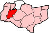
 Addington Location within Kent | |
| Population | 769 (2011 Census)[1] |
| District | |
| Shire county | |
| Region | |
| Country | England |
| Sovereign state | United Kingdom |
| Post town | West Malling |
| Postcode district | ME19 |
| Police | Kent |
| Fire | Kent |
| Ambulance | South East Coast |
| UK Parliament | |

Addington is a village in the English county of Kent. It is close to the M20 motorway, and between the villages of Wrotham Heath and West Malling. The Domesday Book called it Eddintune. The meaning of the village's name is "Æddi's (or Eadda's) estate".[2] The village is notable for the long barrows, Neolithic chamber tombs. Its parish covers a little under 700 acres (2.8 km2), containing 291 houses.[3] Addington Brook runs through the parish.
History[]
Addington has been continuously inhabited for over 5,000 years. Many Neolithic artifacts have been extracted from the village, but much archaeological evidence has been lost to mechanical digging. Some sites were excavated during the building of the motorway. It had two mills at the time of the Domesday survey.[4] There was a watermill powered by the Addington Brook (TQ 656 587 51°18′12″N 0°22′36″E / 51.303227°N 0.376605°E), demolished in the nineteenth century; the site now lies within West Malling Golf Course.[5][6] The remains of an old structure named the Addington Place were visible until the early 21st century, now beneath a golf course and stables.
Features[]
There is one pub, the Angel. There are rumours of a tunnel from the basement to the church 750 m (820 yd) away. No school is in the village, so children attend schools in nearby villages. Addington is completely divided by the M20 and M26 motorways. It is scarred on both sides of the motorways with sandpits and quarries, which are now almost entirely worked out.
The village is home to Addington Village Cricket Club, which has two Saturday teams and a 1st XI in Division 2 of the Kent League (1st XI).

The parish church is dedicated to St. Margaret, currently led by the Reverend Linda Shuker.[3]
Traces of the former gardens of Addington Park can still be seen. Rockeries, ponds and old tennis courts are easily discernible in the private grounds of the Seekers Trust between a church and the golf course.
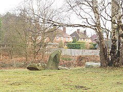
Long barrows[]
Chestnuts[]
The Chestnuts long barrow is the better preserved of the two long barrows. It was excavated in 1957, and artifacts from the dig are displayed in Maidstone Museum. It is believed to be on a Ley line.
Addington[]
Addington long barrow is not well-preserved. Its area has been plundered throughout the history of the village, and there is a road that goes through it.
References[]
- ^ "Civil Parish population 2011". Neighbourhood Statistics. Office for National Statistics. Retrieved 23 September 2016.
- ^ "Kent place names". BBC. Retrieved 9 March 2008.
- ^ Jump up to: a b "Village Information Sheet". Addington Parish Council. Archived from the original on 3 September 2011. Retrieved 9 March 2008.
- ^ Coles Finch, William (1933). Watermills & Windmills. London: C W Daniel Company.
- ^ Fuller & Spain (1986). Watermills (Kent and the Borders of Sussex). Maidstone: Kent Archaeological Society. ISBN 0-906746-08-6.
- ^ "Watermills list". The Mills Archive. Archived from the original on 18 April 2010. Retrieved 9 March 2008.
External links[]
| Wikimedia Commons has media related to Addington, Kent. |
- Addington in the Domesday Book
| show Nearest Settlements |
|---|
| show Authority control |
|---|
- Villages in Kent
- Civil parishes in Kent