M26 motorway
 | ||||
|---|---|---|---|---|
| Route information | ||||
| Maintained by Highways England | ||||
| Length | 15.9 km (9.9 mi) | |||
| Existed | 1980–present | |||
| Major junctions | ||||
| West end | Chevening | |||
M25 motorway Junction 5 M20 motorway Junction 3 | ||||
| East end | Addington | |||
| Location | ||||
| Primary destinations | Sevenoaks | |||
| Road network | ||||
| ||||

The M26 is a motorway in Kent, England. It provides a short link between the M25 at Sevenoaks and the M20 near West Malling.
Route[]
The motorway starts at junction 3 of the M20 and heads west, encountering almost immediately the single junction along its length where it has an interchange with the A20. This junction is numbered 2a to reflect its proximity to the M20's nearby junction 2 (also connecting with the A20) a short distance to the north-west.
8 miles (13 km) to the west the M26 merges with the M25 at junction 5. There is no exit from the M26 at junction 5 and all traffic must join the clockwise (westbound) M25. The next M25 junction, number 6, is 10 miles (16 km) west at Godstone so traffic joining the M26 at Junction 2a cannot leave the motorway for 18 miles (29 km), the longest distance between motorway exits in the UK.[1]
Anti-clockwise direction from the M25, the main carriageway continues directly on to the M26 at junction 5. To remain on the M25, traffic must turn on to the slip road which connects to the M25 spur coming north from Sevenoaks, which is multiplexed with the A21. The awkwardness of junction 5 is a result of the history of the two motorways' planning and construction.
History[]
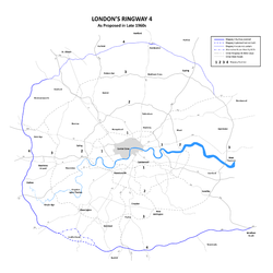
Construction of the M26 began in 1977, although a route on a similar alignment was originally proposed in the Greater London Plan in 1944 as part of proposed post war improvements to London area transport network. Those proposals were developed further in the 1960s as part of the London Ringways plan and the route of the M26 at that time formed part of Ringway 4 and would have been designated as part of the M25.
Construction of the first part of the M25 began in 1972 but before it opened, plans for the London Orbital motorway were modified to combine the southern and western part of Ringway 4 with the northern and eastern part of Ringway 3. To connect the two separate routes, which together were numbered as the M25, an additional section of road needed to be planned and the M25 route was diverted northwards from junction 5 to meet Ringway 3 at Swanley (M25 junction 3).
The remaining section of Ringway 4 became the M26.[2] Until February 1986, the anticlockwise M25 simply became the M26 at Junction 5, as the M25 between Junction 5 and Junction 3 was not opened until then.
Proposed developments[]
New junction[]
Kent County Council has been in talks with the Highways Agency over a possible new junction with the A225, allowing direct access to Sevenoaks – or access to the A21 at the M25 junction.[3]
Brexit contingency planning[]
Plans to modify the M26 to hold large numbers of lorries in the event of a no-deal Brexit were publicly revealed in October 2018.[4][5]
Junctions[]
Data from driver location signs are used to provide carriageway identifier information.[citation needed]
| M26 motorway junctions | |||||
| miles | km | Westbound exits (B carriageway) | Junction | Eastbound exits (A carriageway) | Coordinates |
|---|---|---|---|---|---|
| 0.0 | 0.0 | Road continues as M25 (CW) Gatwick Heathrow Redhill (A25) |
M25 J5 | Start of motorway Dartford Crossing, Stansted M25 (M11, M1) Sevenoaks, Hastings A21 |
51°17′29″N 0°08′34″E / 51.29145°N 0.14282°E |
| 8.6 9.3 |
13.9 15.0 |
Wrotham A20 Sevenoaks (A25) Gravesend (A227) |
J2a | Wrotham A20 Paddock Wood B2016 Gravesend (A227) |
51°18′07″N 0°20′06″E / 51.30207°N 0.33508°E |
| 10.3 | 16.6 | Start of motorway | M20 J3 | Road continues as M20 (E) Maidstone, Channel Tunnel, Dover M20 |
51°18′26″N 0°21′32″E / 51.30733°N 0.35877°E |
Notes
| |||||
| 1.000 mi = 1.609 km; 1.000 km = 0.621 mi | |||||

See also[]
References[]
- ^ "Motorway Database – M26". CBRD. Retrieved 27 January 2007.
- ^ "The Motorway Archive – M26". Motorway Archive Trust. Archived from the original on 2 January 2007. Retrieved 27 January 2007.
- ^ "Local Transport Plan". Kent County Council. Archived from the original on 10 March 2007. Retrieved 27 January 2006.
See 8.37 Improvement
- ^ "UK plan to use motorway as 'parking lot' if no Brexit deal". 11 October 2018.
- ^ Edgington, Tom; Schraer, Rachel (8 April 2019). "No-deal Brexit: What is the UK government doing to prepare?". BBC News. Retrieved 8 April 2019.
External links[]
Route map:
| ( • help)
|

| show |
|---|
- Motorways in England
- Roads in Kent