M49 motorway
 | ||||
|---|---|---|---|---|
| Route information | ||||
| Maintained by Highways England | ||||
| Length | 5.0 mi (8.0 km) | |||
| Existed | 1996–present | |||
| Major junctions | ||||
| North end | Redwick | |||
M4 motorway M5 motorway | ||||
| South end | Lawrence Weston | |||
| Road network | ||||
| ||||
| ||||
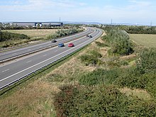
The M49 motorway is just 5 miles (8 km) long and forms a link between the M5 motorway west of Bristol at junction 18A and the M4 motorway at junction 22 before the Second Severn Crossing (now officially renamed the Prince of Wales Bridge). It was constructed at the same time as the bridge in 1996.[1] It is unique in that it is only accessible from other motorways.
Route[]
The M49 begins at junction 18A of the M5 and then heads roughly north and northwest before it reaches its terminal junction with the M4 at junction 22, just before the Second Severn Crossing at Pilning Interchange. It cuts journey times for traffic to and from Avonmouth docks, Central and southern Bristol and South West England.
Compared to driving via the M4/M5 interchange, using the M49 cuts the distance travelled by 6.2 miles. Having a two-way grade separated roundabout junction with the M4, it also fulfils the additional role of providing a bypass for the busy stretch of the M5 between the Avonmouth Bridge and the M4 in case of that route being shut.
Original plans provided for an intermediate junction with the A403, to serve an expanded industrial area and Severn Beach,[2] construction of Junction 1 commenced summer 2018 and was completed late in August 2020.[3] Despite this, the junction is not currently connected to the local road network, so cannot be used to access the motorway.[4]
The M49 is anomalously numbered, as it is entirely to the south of the M4 and should therefore begin with a 3.[5]
Junction 1 link road dispute[]
After the junction itself was completed in August 2020, disputes arose over who should construct the road linking the new Junction 1 to the local road network.[4] The dispute initially emerged between Highways England, South Gloucestershire Council, and the development company Delta Properties, as a result of privately owned land on the development which surrounds the junction.[6]
In February 2021, the West of England Combined Authority agreed to supply £1 million towards the construction of the link road, but by May a further deficit of £1 million had arisen.[7] As of July 2021, the situation remains unsolved.
Junctions[]
This article contains a bulleted list or table of intersections which should be presented in a properly formatted junction table. (December 2021) |
Data from driver location signs are used to provide distance and carriageway identifier information.[8]
| M49 motorway junctions | |||||
| miles | km | North-west bound exits (B carriageway) | Junction | South-east bound exits (A carriageway) | |
|---|---|---|---|---|---|
| 0.0 | 0.0 | Bristol, London M4(E) | M4 J22 terminus |
The South West, Avonmouth M49 | |
| South Wales, Cardiff, Newport M4(W) | Start of motorway | ||||
| 5.3 | 8.5 | Start of motorway | Terminus A4, M5 J18 & J18A |
Avonmouth, Bristol, Airport A4 | |
| South Wales, Cardiff, Newport (M4(W)) M49 | The South West, Weston-s-Mare, M5 | ||||
Notes
| |||||
| 1.000 mi = 1.609 km; 1.000 km = 0.621 mi | |||||
Information above gathered from Advanced Direction Signs May 2011
See also[]
- List of motorways in the United Kingdom
References[]
- ^ CBRD Motorway Database – M49
- ^ Pathetic Motorways – M49
- ^ Highways England - M49 Avonmouth junction
- ^ a b Baker, Hannah (18 August 2020). "New £50M junction on M49 finished – but traffic can't actually use it". BristolLive. Retrieved 22 July 2021.
- ^ "Pathetic Motorways". pathetic.org.uk. Retrieved 22 July 2021.
- ^ Gogarty, Conor; Baker, Hannah (10 February 2021). "Link road to £50m 'dead-end' motorway junction to finally be built". Business Live. Retrieved 22 July 2021.
- ^ Gogarty, Conor (17 May 2021). "Dead-end motorway junction saga descends into 'royal mess'". BristolLive. Retrieved 22 July 2021.
- ^ "Traffic England Live Traffic Condition Map (selected Popups)". Highways Agency. Archived from the original on 10 February 2012. Retrieved 11 November 2009.
External links[]
Route map:

| ( • help)
|
Motorways in the United Kingdom | ||||||
|---|---|---|---|---|---|---|
| Great Britain |  | |||||
| Northern Ireland | ||||||
| Former | ||||||
| Unbuilt | ||||||
| Junctions ( |
| |||||
| Related articles |
| |||||
| ||||||
| South West | |
|---|---|
| Area 3 (South) | |
| Area 4 (South East) |
|
| Area 5 (DBFO) (M25 links) | |
| East | |
| Area 7 (East Midlands) | |
| Area 9 (West Midlands) | |
| North West | |
| Area 12 (Yorks/Lincs) | |
| Area 14 (North East) | |
| Other DBFO | |
| Toll roads |
|
| Road |
| ||||||||||||||
|---|---|---|---|---|---|---|---|---|---|---|---|---|---|---|---|
| Airports and Heliports |
| ||||||||||||||
| Rail |
| ||||||||||||||
| Buses |
| ||||||||||||||
| Waterways |
| ||||||||||||||
| Footpaths |
| ||||||||||||||
| Cycle paths |
| ||||||||||||||
- Motorways in England
- Roads in Bristol
- Transport in South Gloucestershire District