Agew Awi Zone
Agew Awi
አገው አዊ | |
|---|---|
Zone | |
 | |
 Flag | |
| Country | Ethiopia |
| Region | Amhara Region |
| Largest city | Injibara |
| Area | |
| • Total | 9,148.43 km2 (3,532.23 sq mi) |
| Population (2017 est.) | |
| • Total | 1,077,144 |
| • Density | 120/km2 (300/sq mi) |

Agew Awi (Amharic: አገው አዊ) is one of 11 Zones in the Amhara Region of Ethiopia. It is named for the Awi sub-group of the Agaw people, some of whom live in this Zone. Agew Awi Zone is bordered on the west by Benishangul-Gumuz Region, on the north by Semien Gondar Zone and on the east by Mirab Gojjam. The administrative centre of Agew Awi is Injibara; other towns include Chagni, , , , , and Dangila.
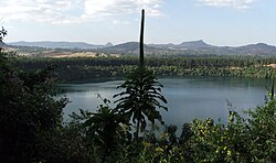
Topographically speaking, Agaw Awi is relatively flat and fertile, whose elevations vary from 1,800 to 3,100 m above sea level, with an average altitude of about 2,300 m. The Zone is crossed by about nine permanent rivers which drain into the Abay (or Blue Nile); other water features include two crater lakes, Zengena and , and Zimbiri marsh which is located 5 km south-west of Addis Kidam. Local forests include Dukma and Apini, which are located on either side of the town of , Zengena forest around Lake Zengena and Goobil forest which is on a dome-shaped hill next to . The Agaw have traditionally practised a land-management system which is well adapted to the local ecology, which enables them to sustain the fertility of the soil and minimize erosion; this area is recognized as one of the most productive in the Amhara Region.[2]
Demographics[]
Based on the 2007 Census conducted by the Central Statistical Agency of Ethiopia (CSA), this Zone has a total population of 982,942, an increase of 37.07% over the 1994 census, of whom 491,865 are men and 491,077 women. With an area of 9,148.43 square km, Agew Awi has a population density of 107.44; 123,014 or 12.51% are urban inhabitants. A total of 215,564 households were counted in this Zone, which results in an average of 4.56 persons to a household, and 209,555 housing units. The two largest ethnic groups reported in Agew Awi were the Awi (59.82%) a subgroup of the Agaw, and the Amhara (38.44%); all other ethnic groups made up 1.74% of the population. Amharic was spoken as a first language by 53.38%, and 45.04% spoke Awngi; the remaining 1.58% spoke all other primary languages reported. 94.4% practiced Ethiopian Orthodox Christianity, and 4.5% of the population said they were Muslim.[3]
The 1994 national census reported a total population for this Zone of 717,085 in 147,917 households, of whom 357,238 were men and 359,847 women; 62,232 or 8.68% of its population were urban dwellers at the time. The three largest ethnic groups reported in Agew Awi were the Awi (49.97%) a subgroup of the Agaw, the Amhara (48.6%), and the Gumuz (0.98%); all other ethnic groups made up 0.45% of the population. Amharic was spoken as a first language by 53.75%, 44.93% Awngi, and 0.98% spoke Gumuz; the remaining 0.34% spoke all other primary languages reported. 93.52% practiced Ethiopian Orthodox Christianity, and 5.41% of the population said they were Muslim.[4]
According to a May 24, 2004 World Bank memorandum, 6% of the inhabitants of Agew Awi have access to electricity, this zone has a road density of 39.6 km per 1000 square km (compared to the national average of 30 km ),[5] the average rural household has 1.2 hectares of land (compared to the national average of 1.01 hectare of land and an average of 0.75 for the Amhara Region)[6] and the equivalent of 0.5 heads of livestock. 13.6% of the population is in non-farm related jobs, compared to the national average of 25% and a Regional average of 21%. 72% of all eligible children are enrolled in primary school, and 16% in secondary schools. 54% of the zone is exposed to malaria, and 76% to Tsetse fly. The memorandum gave this zone a drought risk rating of 420.[7]
Notes[]
- ^ Geohive: Ethiopia Archived 2012-08-05 at the Wayback Machine
- ^ "Important Bird Area factsheet: Awi Zone, Ethiopia", BirdLife International website (accessed 1 September 2009)
- ^ Census 2007 Tables: Amhara Region Archived 2010-11-14 at the Wayback Machine, Tables 2.1, 2.4, 2.5, 3.1, 3.2 and 3.4.
- ^ 1994 Population and Housing Census of Ethiopia: Results for Amhara Region, Vol. 1, part 1 Archived 2010-11-15 at the Wayback Machine, Tables 2.1, 2.11, 2.14, 2.17 (accessed 6 April 2009)
- ^ "Ethiopia - Second Road Sector Development Program Project", p.3 (World Bank Project Appraisal Document, published 19 May 2003)
- ^ Comparative national and regional figures comes from the World Bank publication, Klaus Deininger et al. "Tenure Security and Land Related Investment", WP-2991 Archived 2007-03-10 at the Wayback Machine (accessed 23 March 2006).
- ^ World Bank, Four Ethiopias: A Regional Characterization (accessed 23 March 2006).
| Agew Awi Zone | |
|---|---|
| East Gojjam Zone | |
| North Gondar Zone | |
| North Shewa Zone |
|
| North Wollo Zone | |
| Oromia Zone | |
| South Gondar Zone | |
| South Wollo Zone | |
| Wag Hemra Zone | |
| West Gojjam Zone | |
| Special zones | |
| Special woredas | |

- Amhara Region
- Zones of Ethiopia