Ailladie
| Ailladie | |
|---|---|
| Aill an Daill, The Blind Man's Cliff Ballyreen Cliffs or Ballyreen Point | |
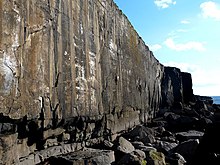
 An Falla Uaigneach, at the southern end of Ailladie | |
 Location of Ailladie in Ireland | |
| Location | |
| Nearest city | 6 km south of Fanore[1] 8 km north of Doolin[1] |
| Range | The Burren |
| Coordinates | 53°04′14″N 09°21′30″W / 53.07056°N 9.35833°WCoordinates: 53°04′14″N 09°21′30″W / 53.07056°N 9.35833°W |
| Climbing type |
|
| Height | circa 35 metres (115 ft) above sea level at its peak |
| Pitches | Single pitch |
| Ratings |
|
| Rock type | Limestone |
| Quantity of rock |
|
| Development |
|
| Cliff aspect | West |
| Elevation | At sea level |
| Camping | |
| Classic climbs | |
| Website | Climbing.ie Ailladie |

Ailladie (Irish: Aill an Daill, lit. 'Blind Man's Cliff'; also known locally as the Ballyreen Cliffs and Ballyreen Point),[3][4] is an 800-metre-long (2,600 ft) west-facing limestone sea cliff, that varies in height from 8 metres (26 ft) to 35 metres (115 ft), situated on the coast of The Burren in County Clare, Ireland. Ailladie is one of Ireland's most highly regarded rock-climbing locations, particularly for high technical grade climbs and deep-water soloing. It is also a location for shore-angling competitions, and, with its cliffs and view of the Aran Islands, a popular photography stop for tourists.[1][2]
Naming[]
The name Ailladie is an anglicized translation from the Irish language name, Aill an Daill, which means The Blind Man's Cliff or Cliff of the Blind Person.[3][1] The cliffs are also referred to locally, and by anglers, as Ballyreen Cliffs and Ballyreen Point, which is another anglicised version of the name given to Ailladie's local townland of Irish: Baile Uí Rinn; Ring's homestead.[4][5][6]
Structure[]
Ailladie is an 800-metre (2,600 ft) long west-facing limestone sea-cliff, varying in height from 8 metres (26 ft) metres to 35 metres (115 ft) metres, that is situated on the coast of The Burren in County Clare, in Ireland.[1] The northernmost sections of the cliff are not sea-cliffs, and their bases can be accessed by various climbing descent routes (see below) to flat limestone shelves below.[1][2] However, the southernmost sections are all sea-cliffs and can only be accessed by rope abseil.[1][2] The cliff straddles the Clare townlands of Ballyryan (southern section),[7] and Crumlin (northern section).[8]
Access[]
Ailladie is hidden from view and is just off the R477 road, 1.5 kilometres (0.93 mi), at a point before the road turns inland and south-east to Lisdoonvarna. The Ailladie car-park (grid M0901102910) is marked on online maps and is opposite the Stone Wall section of the cliff (see Ailladie map below). Beside the car park, to the south, is the smaller rock climbing crag known as Ballyryan (climbers can be seen on the Ballyryan rock face by the passing R477 traffic).
Access to the base of the cliff is only possible without abseiling at the northernmost end, where a 3 metres (9.8 ft) roped fisherman's descent gives access to Ailladie's cliff base, which is a large limestone platform.[1][2]
Rock climbing[]
Sections[]
Ailladie's northern half covers the sections known to climbers as the Dancing Ledges and the Aran Wall,[9] and sits above a large rock platform making it accessible, via the 3-metre roped fisherman's descent (a grassy ramp at the northernmost end of Ailladie), regardless of tides. Ailladie climbers also use the climber's descent area at O'Conner's Corner (10 metres, Diff).[10] The Dancing Ledges is the lowest section of Ailladie with several climbs of 10–15 metres.[1][2]
The first part of Ailladie's southern half is Mirror Wall (mostly graded E4–E7), and it is accessible by boulder-hopping at low-tide, although climbers also abseil down to the start of the climbs.[1] The remainder of the southern half of Ailladie, the Stone Wall, An Falla Uaigneach, and Boulder Wall sections, require abseils for access. Many of the climbs in the imposing An Falla Uaigneach sector have to be started from a hanging belay, and the sector also offers climbers deep water soloing ("DWS") routes at very high grades of difficulty (e.g. grade 7c+), and with significant 30 metres (98 ft) drops.[11]

The rock is limestone, of good clean blue/grey quality and mostly hanging in a sheer vertical form. Its texture is described as "varies from smooth, in the few small areas recently exposed by rockfall, to a sharp popcorn texture which provides excellent friction".[1] Most climbs follow steep narrow finger-crack lines, and the rock climbing protection is considered to be good.[12][1] The last guidebook, published in 2008,[2] lists 170 climbs (the current Ailladie online database, see below, has over 200),[12] nearly all single-pitches, with grades up to E7 6c. Most Ailladie climbs are at and above E1 5b grades; there is little quality below VS 4c grade. The lower sections of some routes, and the climbing grade, can change due to the movements of large boulders in sea storms,[12] and hence why many Mirror Wall climbers start from a hanging belay (see Mirror Wall photograph).[1]
In 2019, On Reflection (E6, 6a), on the Mirror Wall section, was listed in UK Climbing's "The Five Best E6 Routes in the UK and Ireland".[13]
History[]

The climbing potential of Ailladie was discovered in August 1972, when it was visited by a group of Dublin climbers.[14] Word of its quality spread and development began in earnest. Ailladie, and the smaller nearby climbing crags in The Burren area, became recognised as the only on-shore limestone rock climbing locations in Ireland; the others being mainly granite, sandstone and dolerite.[15] Since then, Ailladie has remained at the "cutting edge" of Irish outdoor traditional rock climbing, along with the dolerite Fair Head cliff in County Antrim.[16][12] The UKC described Ailladie as "Best coastal limestone in the world! Fact!".[17] The Irish Examiner said, "The mecca for rock climbing in Ireland is Ailladie".[18] The Irish Times called it "one of Ireland’s best rock-climbing sites".[19]
Facilities[]
Visiting climbers either camp in the fields above the crag (however, there is no source of fresh water), or stay at one of the many hostels in the surrounding villages (particularly Doolin for nightlife and additional bouldering,[20] or Fanore for serviced camping grounds).[1] There are several nearby inland 10–20 metres (33–66 ft) high limestone crags with a good range of graded rock climbs, especially in the grades below VS, that are within walking distance (e.g. Ballyryan) or a short driving distance (e.g. Murroughkilly, Aill na Cronain and Oughtdarra), from Ailladie; however, these do not have anything like the quality or popularity of Ailladie.[21]
Cave diving[]
Beginning at 9.5 m (31 ft) below sea level, Cliff Cave, discovered in 2012, extends inland from the crag. Containing over 2.7 km (1.7 mi) of passages, it is the longest-known marine cave in Ireland.[22][23]
Shore angling[]

The limestone ledges at the base of Ailladie's cliffs (at the far north and far south ends), are regarded for their shore-angling and are described as providing "superb bottom fishing".[24] Anglers know the area as Ballyreen-south of Fanore, and several of the rocks have numbers painted on them for shore-angling competitions.[24] Ballyreen is noted as one of the few shore-angling locations in Clare where sharks (porbeagle and blue), and conger eels have been successfully landed.[25]
Because of the proximity of these low limestone ledges to deep Atlantic waters, the ledges have seen several fatalities over the years of anglers who were caught by sudden swells or large waves, and were carried out to sea.[5][26][27]
Accidents[]
As well as accidents from rock-climbing activities (there are no recorded rock climbing fatalities at Ailladie), and accidents and fatalities from shore-angling activities,[5][26][27] Ailladie has also seen a number of accidents and fatalities from tourist activities as a result of falls at the cliffs.[28]
See also[]
- Aill na Cronain, inland rock climbing limestone crag in County Clare, right beside the Aillwee Cave
- Ballyryan, inland rock climbing limestone crag in County Clare, right beside Ailladie
- Fair Head, major rock climbing dolerite mountain crag in County Antrim
- Dalkey Quarry, major rock climbing granite quarry in Dublin
- List of long-distance trails in the Republic of Ireland
- List of mountains in Ireland
References[]
- ^ a b c d e f g h i j k l m n o Torrans, Calvin; Sheridan, Clare (1997). Climbing guide to the Burren. Mountaineering Council of Ireland. ISBN 978-0-902940-12-3.
- ^ a b c d e f g h i Owens, Peter (2008). Climbs in the Burren and Aran Islands. Mountaineering Ireland. ISBN 978-0-902940-21-5. Retrieved 24 March 2020.
- ^ a b "Aill an Daill (Irish), Ailladie (English)". Placenames Database of Ireland. Retrieved 24 March 2020.
- ^ a b "Ballyryan Townland, Co. Clare". Townland.ie. 2018. Retrieved 24 March 2020.
- ^ a b c "Ballyreen Point". Doolin Coast Guard. 7 November 2009. Retrieved 24 March 2020.
A person had fallen into the sea from the rocks at Ballyreen Point while sea fishing, the sea was quite rough at the time with high waves and strong winds
- ^ "Cliffs of Moher, Aran Islands, Wild Atlantic Way from Galway". Lonely Planet. Retrieved 24 March 2020.
Turning right at Ballyvaughan, your local, driver guide will take you south following the Wild Atlantic Way along the coast of Clare, via Black Head, Fanore Strand, and the baby cliffs of Ballyreen.
- ^ "Ballyran Townland, Co. Clare". Townland.ie. 2018. Retrieved 24 March 2020.
- ^ "Crumlin Townland, Co. Clare". Townland.ie. 2018. Retrieved 24 March 2020.
- ^ Rob Greenwood (10 June 2017). "Outline of Ailladie's 5 Sectors: Dancing Ledges, Aran Wall, Mirror Wall, Stone Wall, An Falla Uaigneach and Boulder Wall". UKClimbing.com. Retrieved 24 March 2020.
- ^ "Ailladie: Climber's Descent and O'Connors Corner (Dancing Ledges Sector)". climbing.ie. Retrieved 24 March 2020.
- ^ "Colm Shannon's Deserted DWS Heaven – Irish West Coast's Ailladie". UKClimbing.com. 7 August 2016. Retrieved 24 March 2020.
- ^ a b c d Rob Greenwood (27 June 2017). "Ailladie, the Burren – Ireland". UKClimbing.com. Retrieved 24 March 2020.
- ^ Greenwood, Rob (24 July 2019). "The Five Best E6 Routes in the UK and Ireland". UK Climbing. Retrieved 6 February 2021.
- ^ Paddy O'Leary (March 2015). The Way That We Climbed. The Collins Press. ISBN 978-1-84889-242-2.
- ^ "Rock climbing in Ireland". climb-europe.com. 2018. Retrieved 24 March 2020.
- ^ Michael Reardon (9 July 2007). "IRISH VISIT: Ailladie (Burren, Co. Clare)". climbing.com. Retrieved 24 March 2020.
The following day brought me to one of my favorite climbing areas on the planet — the great sea cliffs of Ailladie.
- ^ "Ailladie (Burren, Co. Clare)". UKClimbing.com. 2018. Retrieved 24 March 2020.
- ^ Dan McCarthy (July 2011). "Feel on top of the world". Irish Examiner. Retrieved 24 March 2020.
The mecca for rock climbing in Ireland is Ailladie, Co Clare. It sounds like a lost Himalayan kingdom but in fact it is a rural townland just outside Doolin in the Burren, Co Clare.
- ^ Dan McCarthy (29 April 2017). "Cycle series: Ride the roads around Lisdoonvarna". Irish Times. Retrieved 24 March 2020.
- ^ Peter Owens (2008). "Doolin Bouldering" (PDF). Mountaineering Council of Ireland. Archived from the original (PDF) on 26 August 2014. Retrieved 6 August 2018.
- ^ "West Clare Crags". UKClimbing.com. 2018. Retrieved 24 March 2020.
- ^ Warny, Jim; Marek, Michal (October 2014). Barrie, Peter; Kennedy, Alasdair (eds.). "The exploration of Cliff Cave, Oughtdarra, Co. Clare". Irish Speleology. Speleological Union of Ireland. 21: 71–72. ISSN 0332-4907.
- ^ Kluj, Magdalena (2019). Barrie, Peter; Kennedy, Alasdair (eds.). "Obituary: Michał Marek". Irish Speleology. Speleological Union of Ireland. 24: 73–74. ISSN 0332-4907.
- ^ a b "Fishing in Ireland: Galway Bay & North Clare". Angling Ireland. Retrieved 13 November 2018.
There is superb bottom fishing from the rocks at Ballyreen where ray, conger, dogfish, bull huss and plaice are common. Garfish and wrasse can be caught while float fishing, pollack and mackerel to spinners. Occasionally tope will take a bait here and porbeagle shark have also been landed. Ground close to the shore and rocks is very weedy and broken. However, a cast of 60 to 70 Metres will land bait on clean ground. As at Black Head, this area is a popular venue for anglers and the rocks have numbers painted on them for club competitions.
- ^ "Clare: Ballyreen". SEA-ANGLING-IRELAND.ORG. Retrieved 13 November 2018.
Ballyreen This is yet another rock platform mark that demands care and attention. It will require a drop net to land the bigger fish. Species & Techniques: Bottom fishing onto mixed ground will produce thornback ray, dogfish, bull huss and conger eels ... and reputedly it also produces Flatfish including a fair share of plaice. The conger eel fishing in the autumn 2004 has been reported as exceptional with lots of fish over the 13 kilo (30 lbs) specimen mark. There is a very foul bottom close to shore but it moves to sand from 40-50 metres out. This is one of only two marks in Clare (the other being Green Island) from which shark (porbeagle and blue) and tope have been successfully landed, but landing large fish off the cliffs is not a simple task.
- ^ a b "Woman drowns after being swept out to sea in Co Clare". Irish Times. 10 July 2016. Retrieved 24 March 2020.
A 53-year-old woman has drowned after being swept out to sea by a wave in north Clare on Sunday morning. [...] The woman was part of a group that had been fishing at Ballyreen, south of Fanore.
- ^ a b "Anglers return to Ballyreen as search continues for missing Latvian man". Clare Hearald. 8 October 2013. Retrieved 24 March 2020.
The 42-year-old father-of-two from Latvia had been fishing for mackerel at an area known locally as the Fisherman's Climb at Ballyreen near Fanore.
- ^ "Search called off as body lost in Ballyreen is found in Salthill". Clare Champion. 26 January 2017. Retrieved 24 March 2020.
Drone technology had been deployed during the week in the search for the 22-year-old who was reported missing after he failed to return to his tour bus which had stopped at Ballyreen, on the Wild Atlantic Way, between Fanore and Lisdoonvarna, at the designated time of departure.
Climbing bibliography[]
- Torrans, Calvin; Stelfox, Dawson (1984). Rock Climbing In Ireland. Constable. ISBN 978-0-09-465320-7.
- Torrans, Calvin (1986). Rock Climbing Guide to the Burren. Mountaineering Council of Ireland. ISBN 978-0-902940-07-9.
- Torrans, Calvin; Sheridan, Clare (1997). Climbing guide to the Burren. Mountaineering Council of Ireland. ISBN 978-0-902940-12-3.
- Owens, Peter (2008). Climbs in the Burren and Aran Islands. Mountaineering Ireland. ISBN 978-0-902940-21-5.
- Flanagan, David (2014). Rock Climbing in Ireland. Three Rock Books. ISBN 978-0-9567874-2-2.
External links[]
| Wikimedia Commons has media related to Ailladie. |
- IrishClimbingOnlineWiki.ie Ailladie Online Database
- UKClimbing.com Ailladie Online Database
- Forever Young (E7 6c) Ailladie An Falla Uaigneach Sector
- The Ramp (E1 5a 5b) Ailladie Mirror Wall Sector
- Siren (E3 5c) Ailladie Stone Wall Sector
- Eliminator (E5 6b) Ailladie Aran Wall Sector
- Climbing areas of Ireland
- Geography of County Clare
- Tourist attractions in County Clare