Ainata
This article does not cite any sources. (February 2012) |
Ainata
عيناتا | |
|---|---|
Village | |
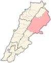
 Ainata Location within Lebanon | |
| Coordinates: 34°11′13″N 36°04′52″E / 34.187°N 36.081°ECoordinates: 34°11′13″N 36°04′52″E / 34.187°N 36.081°E | |
| Country | |
| Governorate | Baalbek-Hermel |
| District | Baalbek |
| Elevation | 1,420 m (4,660 ft) |
| Highest elevation | 1,440 m (4,720 ft) |
| Lowest elevation | 1,400 m (4,600 ft) |
| Population | |
| • Total | 3,000+ |
| Time zone | UTC+2 (EET) |
| • Summer (DST) | UTC+3 (EEST) |
| Dialing code | +961 |

Ainata (Arabic: عيناتا), or sometimes known as Ainata-Al Ariz (عيناتا الأرز), is a Lebanese village, 108 km from Beirut, located in Northern Lebanon, between the Bsharri District and the Baalbek District.
References[]
- Aaynata, Localiban
Capital: Baalbek | ||
| Towns and villages |
|  |
| Other | ||
Categories:
- Populated places in Baalbek District