Bsharri District
Bsharri District | |
|---|---|
District | |
 Kadisha valley, Bsharri District | |
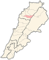
 Location in Lebanon | |
| Country | |
| Governorate | North Governorate |
| Capital | Bsharri |
| Area | |
| • Total | 61 sq mi (158 km2) |
| Population | |
| • Total | 76,831 |
| Time zone | UTC+2 (EET) |
| • Summer (DST) | UTC+3 (EEST) |
Bsharri District is one of the 7 districts (qadaa, قضاء) of the North Governorate, Lebanon.
Overview and geography[]
Surrounded by mountains, the Bsharri District sits on cliffs. The district is bordered by the Zgharta and Miniyeh-Danniyeh Districts to the north, the Koura District to the west, the Baalbek District to the east, and the Batroun District to the south.

This district is a grouping of 26 villages and most are at an elevation higher than 1,000 meters. It also contains one of the most important landmarks of Eastern Christianity and Maronite history, the major part of the Kadisha Valley, the Qannoubin Valley where Hermits have resided since around the year 600 C.E., the last being (fr) whose file in the Vatican is progressing toward beatification. He lived most of his life in the ancient monastery of Saint Elisha located in a grotto deep in the Qannoubin Valley. In this valley, there are more than 26 monasteries all more than 1,000 years old. At the top of this valley sits the legendary cedar forest, the Cedars of God.
Population[]
The neutrality of this section is disputed. (November 2016) |
The population of the district was estimated to be 76,831 by the Ministry of Social Affairs.[1] The capital of the district is Bsharri. The Ministry's estimate lacks credibility. According to the Daily Star, an English language Lebanese newspaper, a total of 40,000 people in the district voted in the 2005 elections. In addition, the Ministry of Social Affairs[2] estimates that 39% of the Lebanese population was under 20 years of age which meant they were not eligible to vote and a 60% participation rate. Considering these factors the population may be more realistically estimated at 100,000 people.[citation needed]
Religion and history[]
The Bsharri district is predominantly Maronite Christian. Having some 37 churches, Bsharri is sometimes called the "City of Churches."[3] Five saints recognized by the Catholic Church hailed from Lebanon. The most prominent is Saint Charbel from Bekaa Kafra, the town with the highest elevation in the district.[4] Many people from Lebanon and other countries in the world greatly honor Saint Charbel, known for his miracles of healing for Christians, Muslims, and those from all religious backgrounds who visit his hometown, seeking his intercession. [5]
Bsharri has deep religious roots for Christianity, as Maronites used the caves within the cliffs to hide and escape religious persecution. These caves could not be reached by horses or heavily armed soldiers. The area survived several invasions including the Ottoman Empire invasion that was marked for its brutality. This Maronite stronghold became a refuge for persecuted Christians in the area, given its geographic characteristics with protective mountains for the towns stretched around the valley. During winter, the snow covers the mountains, and this further isolates the area as it becomes accessible only from two edges at the beginning of Kadisha valley, which translates to the "Holy Valley."[6] This location played a crucial and historical role through the years for the persecuted Maronites who fled to Bsharri.[7][8]
Khalil Gibran[]
Khalil Gibran, a writer, painter, sculptor, and philosopher was born and raised in Bsharri prior to immigrating to the United States of America, where he would spend most of his life. He wrote many books and poems. Among his works are The Prophet, Sand and Foam, and Broken Wings.[9] Some of Gibran's famous quotes include: "You talk when you cease to be at peace with your thoughts," "Beauty is not in the face; beauty is a light in the heart," and "Generosity is giving more than you can, and pride is taking less than you need."[10] The Gibran Museum in Bsharri, founded in 1935, is home to more than 400 of Gibran's original paintings and drawings. It also bears his furniture, personal belongings, and tomb.[11]
Cedars of Lebanon[]

The cedars of Lebanon are also known as the Cedars of God and are mentioned 103[12] times in the Bible. Historically, the timber of these trees was exploited by numerous empires that crossed Lebanon, including the Phoenicians, Assyrians, Egyptians, Turks, Romans, Arabs, Israelites, Persians, and Babylonians.[13] The trees were used by Solomon to build the Temple in Jerusalem and by the Phoenicians to build merchant ships; the resin was used by the Egyptians for mummification.[14]The cedars forest used to grow and thrive across Mount Lebanon and only 375 trees remain today. [15] The cedar tree on the Lebanese flag represents a national symbol, as Lebanon is referred to as the Land of the Cedars[16] and symbolizes eternity, prosperity, and steadiness. [17]
Towns and villages[]
| Abdeen | Beit Minzer | Bsharri | Hadchit | Mazraat Assaf | Tourza |
| Bane | Bekaa Kafra | Brisat | Hasroun | Metrit | |
| Bella | Dimane | Kadisha Valley | Qnaywer | ||
| Bazoun | Blaouza | El-Arz | Kanate | Qnat | |
| Barhalyoun | Bqarqacha | Hadath El Jebbeh | Kanyour |
References[]
- ^ Lebanese Ministry of Environment: "Lebanon State of the Environment Report", Chapter 1, page 13, 2001. Archived 2009-03-25 at the Wayback Machine
- ^ Lebanese Ministry of Environment: "Lebanon State of the Environment Report", Chapter 1, page 14, 2001. Archived 2009-03-25 at the Wayback Machine
- ^ "Small-Group Tour with Lunch to Qadisha Valley, Bcharre and Cedars of God | Marriott". activities.marriott.com. Retrieved 2021-03-23.
- ^ "Bekaa Kafra, the highest village in Lebanon – LebanonUntravelled.com". Retrieved 2021-03-23.
- ^ Brockhaus, Hannah. "The Lebanese saint who unites Christians and Muslims". Catholic News Agency. Retrieved 2021-03-22.
- ^ "Wadi Kadisha, North Governorate". Come To Lebanon. Retrieved 2021-03-23.
- ^ Chaaya, Anis (2016). "The Qadisha Valley, Lebanon". Journal of Eastern Mediterranean Archaeology & Heritage Studies. 4 (2–3): 121–147. doi:10.5325/jeasmedarcherstu.4.2-3.0121. ISSN 2166-3548.
- ^ Traboulsi, Fawwaz (2012), "The Emirate of Mount Lebanon (1523–1842)", A History of Modern Lebanon, Pluto Press, pp. 3–23, ISBN 978-0-7453-3274-1, retrieved 2021-03-23
- ^ "Kahlil Gibran Books - Biography and List of Works - Author of 'The Prophet'". www.biblio.com. Retrieved 2021-03-23.
- ^ Medrut, Flavia (2018-01-11). "Top 26 Most Inspiring Kahlil Gibran Quotes". Goalcast. Retrieved 2021-03-23.
- ^ "Small-Group Tour with Lunch to Qadisha Valley, Bcharre and Cedars of God | Marriott". activities.marriott.com. Retrieved 2021-03-23.
- ^ Centre, UNESCO World Heritage. "Ouadi Qadisha (the Holy Valley) and the Forest of the Cedars of God (Horsh Arz el-Rab)". UNESCO World Heritage Centre. Retrieved 2021-03-22.
- ^ "The Cedars". www.middleeast.com. Retrieved 2021-03-22.
- ^ "Tourism @ Lebanon.com". www.lebanon.com. Retrieved 2021-03-23.
- ^ "Small-Group Tour with Lunch to Qadisha Valley, Bcharre and Cedars of God | Marriott". activities.marriott.com. Retrieved 2021-03-23.
- ^ "In the Land of Cedars". Global Ministries. 2020-01-21. Retrieved 2021-03-23.
- ^ "The rich cultural and biblical symbolism of the Lebanese cedar tree". Aleteia — Catholic Spirituality, Lifestyle, World News, and Culture. 2020-08-06. Retrieved 2021-03-23.
Coordinates: 34°15′04″N 36°00′40″E / 34.251062°N 36.010973°E

- Bsharri District
- Districts of Lebanon
- North Governorate