Aire (Aisne)
| Aire | |
|---|---|
 Aire River at Apremont, France | |
 | |
| Location | |
| Country | France |
| Physical characteristics | |
| Source | |
| • location | French Ardennes |
| Mouth | |
• location | Aisne |
• coordinates | 49°18′28″N 4°49′17″E / 49.30778°N 4.82139°ECoordinates: 49°18′28″N 4°49′17″E / 49.30778°N 4.82139°E |
| Length | 125 km (78 mi) |
| Basin size | 1,043 km2 (403 sq mi) |
| Discharge | |
| • average | 13 m3/s (460 cu ft/s) |
| Basin features | |
| Progression | Aisne→ Oise→ Seine→ English Channel |
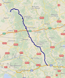
The Aire (French pronunciation: [ɛʁ] (![]() listen)) is a river of northern France, crossing the departments of Meuse and Ardennes. It is a right tributary of the Aisne. It is 124.8 km (77.5 mi) long.[1] Its source is near Saint-Aubin-sur-Aire in Meuse. It flows through the towns of Pierrefitte-sur-Aire, Clermont-en-Argonne, Varennes-en-Argonne and Grandpré, finally flowing into the Aisne in Termes.
listen)) is a river of northern France, crossing the departments of Meuse and Ardennes. It is a right tributary of the Aisne. It is 124.8 km (77.5 mi) long.[1] Its source is near Saint-Aubin-sur-Aire in Meuse. It flows through the towns of Pierrefitte-sur-Aire, Clermont-en-Argonne, Varennes-en-Argonne and Grandpré, finally flowing into the Aisne in Termes.
References[]
Categories:
- Tributaries of the Aisne
- Rivers of France
- Rivers of Grand Est
- Rivers of Meuse (department)
- Rivers of Ardennes (department)
- Grand Est geography stubs
- France river stubs
