River

A river is a natural flowing watercourse, usually freshwater, flowing towards an ocean, sea, lake or another river. In some cases, a river flows into the ground and becomes dry at the end of its course without reaching another body of water. Small rivers can be referred to using names such as stream, creek, brook, rivulet, and rill. There are no official definitions for the generic term river as applied to geographic features,[1] although in some countries or communities a stream is defined by its size. Many names for small rivers are specific to geographic location; examples are "run" in some parts of the United States, "burn" in Scotland and northeast England, and "beck" in northern England. Sometimes a river is defined as being larger than a creek,[2] but not always: the language is vague.[1]
Rivers are part of the hydrological cycle. Water generally collects in a river from precipitation through a drainage basin from surface runoff and other sources such as groundwater recharge, springs, and the release of stored water in natural ice and snowpacks (e.g., from glaciers).
Rivers and streams are often considered major features within a landscape; however, they actually only cover around 0.1% of the land on Earth. They are made more obvious and significant to humans since many human cities and civilizations are built around the freshwater supplied by rivers and streams.[3] Most of the major cities of the world are situated on the banks of rivers, as they are, or were, used as a source of water, for obtaining food, for transport, as borders, as a defensive measure, as a source of hydropower to drive machinery, for bathing, and as a means of disposing of waste.
Potamology is the scientific study of rivers, while limnology is the study of inland waters in general.
Topography

Source and drainage basin
A river begins at a source (or more often several sources) which is usually a watershed, drains all the streams in its drainage basin, follows a path called a rivercourse (or just course) and ends at either at a mouth or mouths which could be a confluence, river delta, etc. The water in a river is usually confined to a channel, made up of a stream bed between banks. In larger rivers there is often also a wider floodplain shaped by flood-waters over-topping the channel. Floodplains may be very wide in relation to the size of the river channel. This distinction between river channel and floodplain can be blurred, especially in urban areas where the floodplain of a river channel can become greatly developed by housing and industry.
The term upriver (or upstream) refers to the direction towards the source of the river, i.e. against the direction of flow. Likewise, the term downriver (or downstream) describes the direction towards the mouth of the river, in which the current flows. The term left bank refers to the left bank in the direction of flow, right bank to the right.
River channel
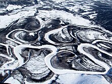
Rivers can flow down mountains, through valleys (depressions) or along plains, and can create canyons or gorges. The river channel typically contains a single stream of water, but some rivers flow as several interconnecting streams of water, producing a braided river.[4] Extensive braided rivers are now found in only a few regions worldwide,[citation needed] such as the South Island of New Zealand. They also occur on peneplains and some of the larger river deltas. Anastamosing rivers are similar to braided rivers and are quite rare. They have multiple sinuous channel - 1 carrying large volumes of sediment. There are rare cases of river bifurcation in which a river divides and the resultant flows ending in different seas. An example is the bifurcation of Nerodime River in Kosovo.
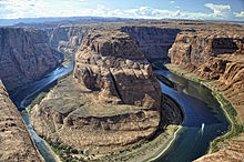
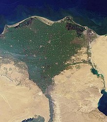
A river flowing in its channel is a source of energy that acts on the river channel to change its shape and form. In 1757, the German hydrologist Albert Brahms empirically observed that the submerged weight of objects that may be carried away by a river is proportional to the sixth power of the river flow speed.[5] This formulation is also sometimes called Airy's law.[6] Thus, if the speed of flow is doubled, the flow would dislodge objects with 64 times as much submerged weight. In mountainous torrential zones, this can be seen as erosion channels through hard rocks and the creation of sands and gravels from the destruction of larger rocks. A river valley that was created from a U-shaped glaciated valley, can often easily be identified by the V-shaped channel that it has carved. In the middle reaches where a river flows over flatter land, meanders may form through erosion of the river banks and deposition on the inside of bends. Sometimes the river will cut off a loop, shortening the channel and forming an oxbow lake or billabong. Rivers that carry large amounts of sediment may develop conspicuous deltas at their mouths. Rivers whose mouths are in saline tidal waters may form estuaries.
Throughout the course of the river, the total volume of water transported downstream will often be a combination of the free water flow together with a substantial volume flowing through sub-surface rocks and gravels that underlie the river and its floodplain (called the hyporheic zone). For many rivers in large valleys, this unseen component of flow may greatly exceed the visible flow.
Types and ratings of rivers

Rivers have been classified by many criteria including their topography, their biotic status, and their relevance to white water rafting or canoeing activities.
Subsurface rivers: Subterranean and Subglacial
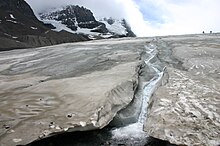
Most but not all rivers flow on the surface. Subterranean rivers flow underground in caves or caverns. Such rivers are frequently found in regions with limestone geologic formations. Subglacial streams are the braided rivers that flow at the beds of glaciers and ice sheets, permitting meltwater to be discharged at the front of the glacier. Because of the gradient in pressure due to the overlying weight of the glacier, such streams can even flow uphill.
Permanence of flow: Perennial and Ephemeral
An intermittent river (or ephemeral river) only flows occasionally and can be dry for several years at a time. These rivers are found in regions with limited or highly variable rainfall, or can occur because of geologic conditions such as a highly permeable river bed. Some ephemeral rivers flow during the summer months but not in the winter. Such rivers are typically fed from chalk aquifers which recharge from winter rainfall. In England these rivers are called bournes and give their name to places such as Bournemouth and Eastbourne. Even in humid regions, the location where flow begins in the smallest tributary streams generally moves upstream in response to precipitation and downstream in its absence or when active summer vegetation diverts water for evapotranspiration. Normally dry rivers in arid zones are often identified as arroyos or other regional names.
The meltwater from large hailstorms can create a slurry of water, hail and sand or soil, forming temporary rivers.[7]
Stream order classification of rivers: Fleuve and Rivière
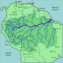
The Strahler Stream Order ranks rivers based on the connectivity and hierarchy of contributing tributaries. Headwaters are first order while the Amazon River is twelfth order. Approximately 80% of the rivers and streams in the world are of the first and second order.
In certain languages, distinctions are made among rivers based on their stream order. In French, for example, rivers that run to the sea are called fleuve, while other rivers are called rivière. For example, in Canada, the Churchill River in Manitoba is called la rivière Churchill as it runs to Hudson Bay, but the Churchill River in Labrador is called le fleuve Churchill as it runs to the Atlantic Ocean. As most rivers in France are known by their names only without the word rivière or fleuve (e.g. la Seine, not le fleuve Seine, even though the Seine is classed as a fleuve), one of the most prominent rivers in the Francophonie commonly known as fleuve is le fleuve Saint-Laurent (the Saint Lawrence River).
Since many fleuves are large and prominent, receiving many tributaries, the word is sometimes used to refer to certain large rivers that flow into other fleuves; however, even small streams that run to the sea are called fleuve (e.g. fleuve côtier, "coastal fleuve").
Topographical classification: Bedrock and Alluvial rivers
Rivers can generally be classified as either alluvial, bedrock, or some mix of the two. Alluvial rivers have channels and floodplains that are self-formed in unconsolidated or weakly consolidated sediments. They erode their banks and deposit material on bars and their floodplains.
Bedrock rivers
Bedrock rivers form when the river downcuts through the modern sediments and into the underlying bedrock. This occurs in regions that have experienced some kind of uplift (thereby steepening river gradients) or in which a particularly hard lithology causes a river to have a steepened reach that has not been covered in modern alluvium. Bedrock rivers very often contain alluvium on their beds; this material is important in eroding and sculpting the channel. Rivers that go through patches of bedrock and patches of deep alluvial cover are classified as mixed bedrock-alluvial.
Alluvial rivers sub-types: Youthful, Mature, Old and Rejuvenated
Alluvial rivers can be further classified by their channel pattern as meandering, braided, wandering, anastomose, or straight. The morphology of an alluvial river reach is controlled by a combination of sediment supply, substrate composition, discharge, vegetation, and bed aggradation.
At the start of the 20th century William Morris Davis devised the "cycle of erosion" method of classifying rivers based on their "age". Although Davis's system is still found in many books today, after the 1950s and 1960s it became increasingly criticized and rejected by geomorphologists. His scheme did not produce testable hypotheses and was therefore deemed non-scientific.[8] Examples of Davis's river "ages" include:
- Youthful river: A river with a steep gradient that has very few tributaries and flows quickly. Its channels erode deeper rather than wider. Examples are the Brazos, Trinity and Ebro rivers.
- Mature river: A river with a gradient that is less steep than those of youthful rivers and flows more slowly. A mature river is fed by many tributaries and has more discharge than a youthful river. Its channels erode wider rather than deeper. Examples are the Mississippi, Saint Lawrence, Danube, Ohio, Thames and Paraná rivers.
- Old river: A river with a low gradient and low erosive energy. Old rivers are characterized by flood plains. Examples are the Yellow, lower Ganges, Tigris, Euphrates, Indus and lower Nile rivers.
- Rejuvenated river: A river with a gradient that is raised by tectonic uplift. Examples are the Rio Grande and Colorado River.
The ways in which a river's characteristics vary between its upper and lower course are summarized by the Bradshaw model. Power-law relationships between channel slope, depth, and width are given as a function of discharge by "river regime".
Biotic classification of rivers: Crenon, Rhithron, Potamon
There are several systems of classification based on biotic conditions typically assigning classes from the most oligotrophic or unpolluted through to the most eutrophic or polluted.[9] Other systems are based on a whole eco-system approach such as developed by the New Zealand Ministry for the Environment.[10] In Europe, the requirements of the Water Framework Directive has led to the development of a wide range of classification methods including classifications based on fishery status[11]
A system of river zonation used in francophone communities[12][13] divides rivers into three primary zones:
- The crenon is the uppermost zone at the source of the river. It is further divided into the eucrenon (spring or boil zone) and the hypocrenon (brook or headstream zone). These areas have low temperatures, reduced oxygen content and slow moving water.
- The rhithron is the upstream portion of the river that follows the crenon. It has relatively cool temperatures, high oxygen levels, and fast, turbulent, swift flow.
- The potamon is the remaining downstream stretch of river. It has warmer temperatures, lower oxygen levels, slow flow and sandier bottoms.
The International Scale of River Difficulty is used to rate the challenges of navigation—particularly those with rapids. Class I is the easiest and Class VI is the hardest.
Flow of river
Studying the flows of rivers is one aspect of hydrology.[14]
Flow Characteristics
Flow Direction

Rivers flow downhill with their power derived from gravity. The direction can involve all directions of the compass and can be a complex meandering path.[15][16][17]
Rivers flowing downhill, from river source to river mouth, do not necessarily take the shortest path. For alluvial streams, straight and braided rivers have very low sinuosity and flow directly down hill, while meandering rivers flow from side to side across a valley. Bedrock rivers typically flow in either a fractal pattern, or a pattern that is determined by weaknesses in the bedrock, such as faults, fractures, or more erodible layers.
Flow rate
Volumetric flow rate, also known as discharge, volume flow rate, and rate of water flow, is the volume of water which passes through a given cross-section of the river channel per unit time. It is typically measured in cubic metres per second (cumec) or cubic feet per second (cfs), where 1 m3/s = 35.51 ft3/s; it is sometimes also measured in litres or gallons per second.
Volumetric flow rate can be thought of as the mean velocity of the flow through a given cross-section, times that cross-sectional area. Mean velocity can be approximated through the use of the Law of the Wall. In general, velocity increases with the depth (or hydraulic radius) and slope of the river channel, while the cross-sectional area scales with the depth and the width: the double-counting of depth shows the importance of this variable in determining the discharge through the channel.
Effects of flow
Fluvial erosion
In its youthful stage the river causes erosion in the water-course, deepening the valley. Hydraulic action loosens and dislodges the rock which further erodes the banks and the river bed. Over time, this deepens the river bed and creates steeper sides which are then weathered.
The steepened nature of the banks causes the sides of the valley to move downslope causing the valley to become V-shaped.
Waterfalls also form in the youthful river valley where a band of hard rock overlays a layer of soft rock. Differential erosion occurs as the river erodes the soft rock more readily than the hard rock, this leaves the hard rock more elevated and stands out from the river below. A plunge pool forms at the bottom and deepens as a result of hydraulic action and abrasion.[18]
Flooding
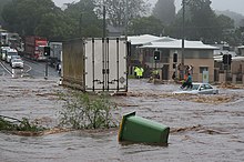

Flooding is a natural part of a river's cycle. The majority of the erosion of river channels and the erosion and deposition on the associated floodplains occur during the flood stage. In many developed areas, human activity has changed the form of river channels, altering magnitudes and frequencies of flooding. Some examples of this are the building of levees, the straightening of channels, and the draining of natural wetlands. In many cases human activities in rivers and floodplains have dramatically increased the risk of flooding. Straightening rivers allows water to flow more rapidly downstream, increasing the risk of flooding places further downstream. Building on flood plains removes flood storage, which again exacerbates downstream flooding. The building of levees only protects the area behind the levees and not those further downstream. Levees and flood-banks can also increase flooding upstream because of the back-water pressure as the river flow is impeded by the narrow channel banks. Detention basins finally also reduce the risk of flooding significantly by being able to take up some of the flood water.
Sediment yield at outlet
Sediment yield is the total quantity of particulate matter (suspended or bedload) reaching the outlet of a drainage basin over a fixed time frame. Yield is usually expressed as kilograms per square kilometre per year. Sediment delivery processes are affected by a myriad of factors such as drainage area size, basin slope, climate, sediment type (lithology), vegetation cover, and human land use / management practices. The theoretical concept of the 'sediment delivery ratio' (ratio between yield and total amount of sediment eroded) indicates that not all of the sediment is eroded within a certain catchment that reaches out to the outlet (due to, for example, deposition on floodplains). Such storage opportunities are typically increased in catchments of larger size, thus leading to a lower yield and sediment delivery ratio.
Brackish water
Brackish waster occurs in most rivers where they meet the sea. The extent of brackish water may extend a significant distance upstream, especially in areas with high tidal ranges.
Ecosystem of rivers
River biota
The organisms in the riparian zone respond to changes in river channel location and patterns of flow. The ecosystem of rivers is generally described by the river continuum concept, which has some additions and refinements to allow for dams and waterfalls and temporary extensive flooding. The concept describes the river as a system in which the physical parameters, the availability of food particles and the composition of the ecosystem are continuously changing along its length. The food (energy) that remains from the upstream part is used downstream.
The general pattern is that the first order streams contain particulate matter (decaying leaves from the surrounding forests) which is processed there by shredders like Plecoptera larvae. The products of these shredders are used by collectors, such as Hydropsychidae, and further downstream algae that create the primary production become the main food source of the organisms. All changes are gradual and the distribution of each species can be described as a normal curve, with the highest density where the conditions are optimal. In rivers succession is virtually absent and the composition of the ecosystem stays fixed .
River Chemistry
The chemistry of rivers is complex and depends on inputs from the atmosphere, the geology through which it travels and the inputs from man's activities. The chemical composition of the water has a large impact on the ecology of that water for both plants and animals and it also affects the uses that may be made of the river water. Understanding and characterising river water chemistry requires a well designed and managed sampling and analysis.
Uses of rivers
Construction material
The coarse sediments, gravel, and sand, generated and moved by rivers are extensively used in construction. In parts of the world this can generate extensive new lake habitats as gravel pits re-fill with water. In other circumstances it can destabilise the river bed and the course of the river and cause severe damage to spawning fish populations which rely on stable gravel formations for egg laying. In upland rivers, rapids with whitewater or even waterfalls occur. Rapids are often used for recreation, such as whitewater kayaking.[19]
Energy production

Fast flowing rivers and waterfalls are widely used as sources of energy, via watermills and hydroelectric plants. Evidence of watermills shows them in use for many hundreds of years, for instance in Orkney at Dounby Click Mill. Prior to the invention of steam power, watermills for grinding cereals and for processing wool and other textiles were common across Europe. In the 1890s the first machines to generate power from river water were established at places such as Cragside in Northumberland and in recent decades there has been a significant increase in the development of large scale power generation from water, especially in wet mountainous regions such as Norway.
Food source
Rivers have been a source of food since pre-history.[20] They are often a rich source of fish and other edible aquatic life, and are a major source of fresh water, which can be used for drinking and irrigation. Rivers help to determine the urban form of cities and neighbourhoods and their corridors often present opportunities for urban renewal through the development of foreshoreways such as river walks. Rivers also provide an easy means of disposing of waste water and, in much of the less developed world, other wastes.
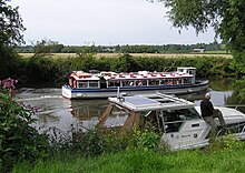
Rivers have been used for navigation for thousands of years. The earliest evidence of navigation is found in the Indus Valley Civilization, which existed in northwestern India around 3300 BC.[21] Riverine navigation provides a cheap means of transport, and is still used extensively on most major rivers of the world like the Amazon, the Ganges, the Nile, the Mississippi, and the Indus. Since river boats are often not regulated, they contribute a large amount to global greenhouse gas emissions, and to local cancer due to inhaling of particulates emitted by the transports.[22][23]
In some heavily forested regions such as Scandinavia and Canada, lumberjacks use the river to float felled trees downstream to lumber camps for further processing, saving much effort and cost by transporting the huge heavy logs by natural means.[24]
Political borders
Rivers have been important in determining political boundaries and defending countries. For example, the Danube was a long-standing border of the Roman Empire, and today it forms most of the border between Bulgaria and Romania. The Mississippi in North America and the Rhine in Europe are major east-west boundaries in those continents. The Orange and Limpopo Rivers in southern Africa form the boundaries between provinces and countries along their routes.
Sacred rivers
Sacred rivers and their reverence is a phenomenon found in several religions, especially religions which have eco-friendly belief as core of their religion. For example, the Indian-origin religions (Buddhism, Hinduism, Jainism, and Sikism) revere and preserve the groves, trees, mountains and rivers as sacred. Among the most sacred rivers in Hinduism are the Ganges,[25] Yamuna,[26][27] Sarasvati[28] rivers on which the rigvedic rivers flourished. The vedas and Gita, the most sacred of hindu texts were written on the banks of Sarasvati river which were codified during the Kuru kingdom in present day Haryana. Among other secondary sacred rivers of Hinduism are Narmada[29] and many more.
Management of rivers
Rivers are often managed or controlled to make them more useful or less disruptive to human activity.
- Dams or weirs may be built to control the flow, store water, or extract energy.
- Levees, known as dikes in Europe, may be built to prevent river water from flowing on floodplains or floodways.
- Canals connect rivers to one another for water transfer or navigation.
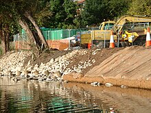
- River courses may be modified to improve navigation, or straightened to increase the flow rate.
River management is a continuous activity as rivers tend to 'undo' the modifications made by people. Dredged channels silt up, sluice mechanisms deteriorate with age, levees and dams may suffer seepage or catastrophic failure. The benefits sought through managing rivers may often be offset by the social and economic costs of mitigating the bad effects of such management. As an example, in parts of the developed world, rivers have been confined within channels to free up flat flood-plain land for development. Floods can inundate such development at high financial cost and often with loss of life.
Rivers are increasingly managed for habitat conservation, as they are critical for many aquatic and riparian plants, resident and migratory fishes, waterfowl, birds of prey, migrating birds, and many mammals.
Concerns
This section needs expansion. You can help by . (July 2021) |
Man-made causes, such as the over-exploitation and pollution, are the biggest threats and concerns which are making rivers ecologically dead and drying up the rivers.
Plastic pollution imposes threats on aquatic life and river ecosystems because of plastic's durability in the natural environment. Plastic debris may result in entanglement and ingestion by aquatic life such as turtles, birds, and fish, causing severe injury and death. Human livelihoods around rivers are also impacted by plastic pollution through direct damage to shipping and transport vessels, effects on tourism or real estate value, and the clogging of drains and other hydraulic infrastructure leading to increased flood risk.[30]
See also
- Arts, entertainment, and media
- "Old Man River"
- The Riverkeepers (book)
- General
- Drought
- Fluvial
- Salt tide
- Water conflict
- Crossings
- Bridge
- Ferry
- Ford (crossing)
- Tunnel
- Habitats
- Lists
- Lists of rivers
- List of international border rivers
- List of rivers by continent
- List of rivers by discharge
- List of rivers by length
- List of waterways
- Transport
References
- ^ Jump up to: a b "Mapping, Remote Sensing, and Geospatial Data: What is the difference between 'mountain', 'hill', and 'peak'; 'lake' and 'pond'; or 'river' and 'creek?'". United States Geological Survey. Retrieved 25 August 2019.
- ^ "WordNet Search: River". The Trustees of Princeton University. Retrieved 2 October 2009.
- ^ Basic Biology (16 January 2016). "River".
- ^ Walther, John V. (15 February 2013). Earth's Natural Resources. Jones & Bartlett Publishers. ISBN 978-1-4496-3234-2.
- ^ Garde, R.J. (1995). History of fluvial hydraulics. New Age Publishers. p. 14. ISBN 978-81-224-0815-7. OCLC 34628134.
- ^ Garde, R.J. (1995). History of fluvial hydraulics. New Age Publishers. p. 19. ISBN 978-81-224-0815-7. OCLC 34628134.
- ^ "Sand River" in Iraq is actually a rapid movement of ice blocks. Tampabayreview.com. Retrieved on 14 July 2016.
- ^ Castree, Noel (2006). Questioning geography: fundamental debates. Wiley-Blackwell. pp. 84–85. ISBN 978-1-4051-0192-9.
- ^ River Classification scheme. sepa.org.uk
- ^ NZ's River Environment Classification system (REC). maf.govt.nz
- ^ Noble, Richard and Cowx, Ian et al. (May 2002) Compilation and harmonisation of fish species classification. University of Hull, UK. A project under the 5th Framework Programme Energy, Environment and Sustainable Management. Key Action 1: Sustainable Management and Quality of Water
- ^ Illies, J.; Botosaneanu, L. (1963). "Problémes et méthodes de la classification et de la zonation éologique des eaux courantes, considerées surtout du point de vue faunistique". Mitt. Int. Ver. Theor. Angew. Limnol. 12: 1–57.
- ^ Hawkes, H.A. (1975). River zonation and classification. River ecology. Blackwell. pp. 312–374.
- ^ Cave, Cristi. "How a River Flows". Stream Biology and Ecology. Archived from the original on 1 January 2015.
- ^ Rosenberg, Matt (8 June 2006). "Do All Rivers Flow South?". About.com.
- ^ Rosenberg, Matt. "Rivers Flowing North: Rivers Only Flow Downhill; Rivers Do Not Prefer to Flow South". About.com.
- ^ Rydell, Nezette (16 March 1997). "Re: What determines the direction of river flow? Elevation, Topography, Gravity??". Earth Sciences.
- ^ "Landforms of the upper valley". www.coolgeography.co.uk. Retrieved 2 December 2016.
- ^ Draper, Nick; Hodgson, Christopher (2008). Adventure Sport Physiology. John Wiley & Sons. ISBN 978-0-470-31913-0.
- ^ "National Museum of Prehistory-The Peinan Site-Settlements of the Prehistoric Times". nmp.gov.tw.
- ^ "WWF – The World's Rivers". panda.org.
- ^ Meybeck, Michel (1993). "Riverine transport of atmospheric carbon: Sources, global typology and budget". Water, Air, & Soil Pollution. 70 (1–4): 443–463. Bibcode:1993WASP...70..443M. doi:10.1007/BF01105015. S2CID 189854355.
- ^ Albrecht, Achim (2003). "Validating riverine transport and speciation models using nuclear reactor-derived radiocobalt". Journal of Environmental Radioactivity. 66 (3): 295–307. doi:10.1016/S0265-931X(02)00133-9. PMID 12600761.
- ^ "Logging Camps: The Early Years". Minnesota DNR.
- ^ Alter, Stephen (2001), Sacred Waters: A Pilgrimage Up the Ganges River to the Source of Hindu Culture, Houghton Mifflin Harcourt Trade & Reference Publishers, ISBN 978-0-15-100585-7, retrieved 30 July 2013
- ^ Jain, Sharad K.; Pushpendra K. Agarwal; Vijay P. Singh (2007). Hydrology and water resources of India—Volume 57 of Water science and technology library. Springer. pp. 344–354. ISBN 978-1-4020-5179-1.
- ^ Hoiberg, Dale (2000). Students' Britannica India, Volumes 1-5. Popular Prakashan. pp. 290–291. ISBN 0-85229-760-2.
- ^ "Sarasvati | Hindu deity". Encyclopedia Britannica.
- ^ "Narmadāparikramā – Circumambulation of the Narmadā River". Brill. Archived from the original on 17 September 2013. Retrieved 3 March 2014.
- ^ van Emmerik, Tim; Schwarz, Anna (January 2020). "Plastic debris in rivers". WIREs Water. 7 (1). doi:10.1002/wat2.1398.
Further reading
| The Wikibook Historical Geology has a page on the topic of: Rivers |
 Definitions from Wiktionary
 Media from Wikimedia Commons
 News from Wikinews
 Quotations from Wikiquote
 Texts from Wikisource
 Textbooks from Wikibooks
 Resources from Wikiversity
- Jeffrey W. Jacobs. "Rivers, Major World". Rivers, Major World – dam, sea, effects, important, largest, salt, types, system, source. Water Encyclopaedia.
- Luna B. Leopold (1994). A View of the River. Harvard University Press. ISBN 978-0-674-93732-1. OCLC 28889034. — a non-technical primer on the geomorphology and hydraulics of water.
- Middleton, Nick (2012). Rivers: a very short introduction. New York: Oxford University Press. ISBN 978-0-19-958867-1.

| show Authority control |
|---|
- Rivers
- Bodies of water
- Fluvial landforms
- Geomorphology
- Sedimentology
- Water streams