Riparian zone
This article includes a list of general references, but it remains largely unverified because it lacks sufficient corresponding inline citations. (August 2009) |
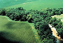
A riparian zone or riparian area is the interface between land and a river or stream.[1] Riparian is also the proper nomenclature for one of the terrestrial biomes of the Earth. Plant habitats and communities along the river margins and banks are called riparian vegetation, characterized by hydrophilic plants. Riparian zones are important in ecology, environmental resource management, and civil engineering because of their role in soil conservation, their habitat biodiversity, and the influence they have on fauna and aquatic ecosystems, including grasslands, woodlands, wetlands, or even non-vegetative areas. In some regions, the terms riparian woodland, riparian forest, riparian buffer zone, riparian corridor, and riparian strip are used to characterize a riparian zone. The word riparian is derived from Latin ripa, meaning "river bank".
Characteristics[]
Riparian zones may be natural or engineered for soil stabilization or restoration. These zones are important natural biofilters, protecting aquatic environments from excessive sedimentation, polluted surface runoff, and erosion. They supply shelter and food for many aquatic animals and shade that limits stream temperature change. When riparian zones are damaged by construction, agriculture or silviculture, biological restoration can take place, usually by human intervention in erosion control and revegetation. If the area adjacent to a watercourse has standing water or saturated soil for as long as a season, it is normally termed a wetland because of its hydric soil characteristics. Because of their prominent role in supporting a diversity of species,[2] riparian zones are often the subject of national protection in a biodiversity action plan. These are also known as a "plant or vegetation waste buffer".
Research shows that riparian zones are instrumental in water quality improvement for both surface runoff and water flowing into streams through subsurface or groundwater flow. Riparian zones can play a role in lowering nitrate contamination in surface runoff, such as manure and other fertilizers from agricultural fields, that would otherwise damage ecosystems and human health. Particularly, the attenuation of nitrate or denitrification of the nitrates from fertilizer in this buffer zone is important. The use of wetland riparian zones shows a particularly high rate of removal of nitrate entering a stream and thus has a place in agricultural management. Also in terms of carbon transport from terrestrial ecosystems to aquatic ecosystems, riparian groundwater can play an important role.[3] As such, a distinction can be made between parts of the riparian zone that connect large parts of the landscape to streams, and riparian areas with more local groundwater contributions.[4]
Roles and functions[]

Riparian zones dissipate stream energy. The meandering curves of a river, combined with vegetation and root systems, slow the flow of water, which reduces soil erosion and flood damage. Sediment is trapped, reducing suspended solids to create less turbid water, replenish soils, and build stream banks. Pollutants are filtered from surface runoff, enhancing water quality via biofiltration.
The riparian zones also provide wildlife habitat, increased biodiversity, and wildlife corridors, enabling aquatic and riparian organisms to move along river systems avoiding isolated communities. Riparian vegetation can also provide forage for wildlife and livestock.
Riparian zones are also important for the fish that live within rivers, such as brook and charr. Impacts on riparian zones can affect fish, and restoration is not always sufficient to recover fish populations.[5]
They provide native landscape irrigation by extending seasonal or perennial flows of water. Nutrients from terrestrial vegetation (e.g. plant litter and insect drop) are transferred to aquatic food webs. The vegetation surrounding the stream helps to shade the water, mitigating water temperature changes. The vegetation also contributes wood debris to streams, which is important to maintaining geomorphology.
From a social aspect, riparian zones contribute to nearby property values through amenity and views, and they improve enjoyment for footpaths and bikeways through supporting foreshoreway networks. Space is created for riparian sports such as fishing, swimming, and launching for vessels and paddle craft.
The riparian zone acts as a sacrificial erosion buffer to absorb impacts of factors including climate change, increased runoff from urbanization, and increased boat wake without damaging structures located behind a setback zone.
Role in logging[]
The protection of riparian zones is often a consideration in logging operations. The undisturbed soil, soil cover, and vegetation provide shade, plant litter, and woody material, and reduce the delivery of soil eroded from the harvested area. Factors such as soil types and root structures, climatic conditions, and vegetative cover determine the effectiveness of riparian buffering.
Vegetation[]

The assortment of riparian zone trees varies from those of wetlands and typically consists of plants that are either emergent aquatic plants, or herbs, trees and shrubs that thrive in proximity to water.
North America[]
Water's edge[]
Herbaceous Perennial:
- Peltandra virginica – Arrow Arum
- Sagittaria lancifolia – Arrowhead
- Carex stricta – Tussock Sedge
- Iris virginica – Southern Blue Flag Iris
Inundated riparian zone[]
Herbaceous Perennial:[6][unreliable source?]
- Sagittaria latifolia – Duck Potato
- Schoenoplectus tabernaemontani – Softstem Bulrush
- Scirpus americanus – Three-square Bulrush
- Eleocharis quadrangulata – Square-stem Spikerush
- Eleocharis obtusa – Spikerush
Western[]
In western North America and the Pacific coast, the riparian vegetation includes:
Riparian trees[7]
- Sequoia sempervirens – Coast Redwood
- Thuja plicata – Western Redcedar
- Abies grandis – Grand Fir
- Picea sitchensis – Sitka Spruce
- Chamaecyparis lawsoniana – Port Orford-cedar
- Taxus brevifolia – Pacific Yew
- Populus fremontii – Fremont Cottonwood
- Populus trichocarpa – Black Cottonwood
- Platanus racemosa – California Sycamore
- Alnus rhombifolia – White Alder
- Alnus rubra – Red Alder
- Acer macrophyllum – Big-leaf Maple
- Fraxinus latifolia – Oregon ash
- Prunus emarginata – Bitter Cherry
- Salix lasiolepis – Arroyo Willow
- Salix lucida – Pacific Willow
- Quercus agrifolia – Coast live oak
- Quercus garryana – Garry oak
- Populus tremuloides – Quaking Aspen
- Umbellularia californica – California Bay Laurel
- Cornus nuttallii – Pacific Dogwood
Riparian shrubs[7]
- Acer circinatum – Vine Maple
- Ribes spp. – Gooseberies and Currants
- Rosa pisocarpa – Swamp Rose or Cluster Rose
- Symphoricarpos albus – Snowberry
- Spiraea douglasii – Douglas spirea
- Rubus spp. – Blackberries, Raspberries, Thimbleberry, Salmonberry
- Rhododendron occidentale – Western Azalea
- Oplopanax horridus – Devil's Club
- Oemleria cerasiformis – Indian Plum, Osoberry
- Lonicera involucrata – Twinberry
- Cornus stolonifera – Red-osier Dogwood
- Salix spp. – Willows
Other plants
- Polypodium – Polypody Ferns
- Polystichum – Sword Ferns
- Woodwardia – Giant Chain Ferns
- Pteridium – Goldback Ferns
- Dryopteris – Wood Ferns
- Adiantum – Maidenhair Ferns
- Carex spp. – Sedges
- Juncus spp. – Rushes
- Festuca californica – California Fescue bunchgrass
- Leymus condensatus – Giant Wildrye bunchgrass
- Melica californica – California Melic bunchgrass
- Mimulus spp. – Monkeyflower and varieties
- Aquilegia spp. – Columbine
Asia[]
In Asia there are different types of riparian vegetation, but the interactions between hydrology and ecology are similar as occurs in other geographic areas.[8]
- Carex spp. – Sedges
- Juncus spp. – Rushes
Australia[]

Typical riparian vegetation in temperate New South Wales, Australia include:
- Acacia melanoxylon – Blackwood
- Acacia pravissima – Ovens Wattle
- Acacia rubida – Red Stem Wattle
- – Blackthorn
- Callistemon citrinus – Crimson Bottlebrush
- Callistemon sieberi – River Bottlebrush
- Casuarina cunninghamiana – River She-Oak
- Eucalyptus bridgesiana – Apple Box
- Eucalyptus camaldulensis – River Red Gum
- Eucalyptus melliodora – Yellow Box
- Eucalyptus viminalis – Manna Gum
- Kunzea ericoides – Burgan
- Leptospermum obovatum – River Tea-Tree
- Melaleuca ericifolia – Swamp Paperbark
Central Europe[]
Typical riparian zone trees in Central Europe include:
- Acer campestre – Field Maple
- Acer pseudoplatanus – Sycamore Maple
- Alnus glutinosa – Black Alder
- Carpinus betulus – European Hornbeam
- Fraxinus excelsior – European Ash
- Juglans regia – Persian Walnut
- Malus sylvestris – European Wild Apple
- Populus alba – White Poplar
- Populus nigra – Black Poplar
- Quercus robur – Pedunculate Oak
- Salix alba – White Willow
- Salix fragilis – Crack Willow
- Tilia cordata – Small-leaved Lime
- Ulmus laevis – European White Elm
- Ulmus minor – Field Elm
Repair and restoration[]
Land clearing followed by floods can quickly erode a riverbank, taking valuable grasses and soils downstream, and later allowing the sun to bake the land dry. Natural Sequence Farming techniques have been used in the Upper Hunter Valley of New South Wales, Australia, in an attempt to rapidly restore eroded farms to optimum productivity.[citation needed]
The Natural Sequence Farming technique involves placing obstacles in the water's pathway to lessen the energy of a flood, and help the water to deposit soil and seep into the flood zone. Another technique is to quickly establish ecological succession by encouraging fast-growing plants such as "weeds" (pioneer species) to grow. These may spread along the watercourse and cause environmental degradation, but may stabilize the soil, place carbon into the ground, and protect the land from drying. The weeds will improve the streambeds so that trees and grasses can return, and later ideally replace the weeds. There are several other techniques used by government and non-government agencies to address riparian and streambed degradation, ranging from the installation of bed control structures such as log sills to the use of pin groynes or rock emplacement.

Cottonwood Creek riparian area in southeastern Oregon before restoration, 1988

Cottonwood Creek riparian area during recovery, 2000
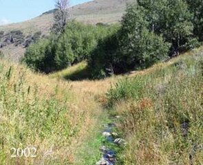
Cottonwood Creek riparian area after restoration, 2002


See also[]
- Accropode
- Aquatic ecosystem
- Bioswale
- Bosque
- Constructed wetland
- Endorheic basin
- Flood-meadow
- Floodplain
- Freshwater swamp forest
- Gallery forest
- Green belt
- Marsh
- Outwelling
- Riparian water rights
- Riparian-zone restoration
- Riprap
- Várzea forest
- Vernal pool
- Vulnerable waters
- Water-meadow
- Wetland
References[]
- ^ "Riparian Areas Environmental Uniqueness, Functions, and Values". Archived from the original on 2020-06-11.
- ^ "The Ecology of Interfaces—Riparian Zones" (PDF). Archived (PDF) from the original on 2018-11-23. Retrieved 2020-06-11.
- ^ Ledesma, José L. J.; Grabs, Thomas; Bishop, Kevin H.; Schiff, Sherry L.; Köhler, Stephan J. (August 2015). "Potential for long-term transfer of dissolved organic carbon from riparian zones to streams in boreal catchments". Global Change Biology. 21 (8): 2963–2979. doi:10.1111/gcb.12872. PMID 25611952.
- ^ Leach, J. A.; Lidberg, W.; Kuglerová, L.; Peralta-Tapia, A.; Ågren, A.; Laudon, H. (July 2017). "Evaluating topography-based predictions of shallow lateral groundwater discharge zones for a boreal lake-stream system". Water Resources Research. 53 (7): 5420–5437. doi:10.1002/2016WR019804.
- ^ Sievers, Michael; Hale, Robin; Morrongiello, John R. (March 2017). "Do trout respond to riparian change? A meta-analysis with implications for restoration and management". Freshwater Biology. 62 (3): 445–457. doi:10.1111/fwb.12888.
- ^ "List of trees and plants". Archived from the original (xls) on July 18, 2011. Retrieved 2010-09-29.
- ^ Jump up to: a b Cooke, Sarah Spear (1997). A Field Guide to the Common Wetland Plants of Western Washington and Northwestern Oregon. Seattle, Washington: Seattle Audubon Society. ISBN 978-0-914516-11-8.
- ^ "Riparian Vegetation Along the Middle and Lower Zones of the Chalakkudy River, Kerala, India" (PDF). Kerala Research Programme Centre for Development Studies. Archived from the original (PDF) on 2009-03-19. Retrieved 2009-10-02.
Further reading[]
- Nakasone, H.; Kuroda, H.; Kato, T.; Tabuchi, T. (2003). "Nitrogen removal from water containing high nitrate nitrogen in a paddy field (wetland)". Water Science and Technology. 48 (10): 209–216. doi:10.2166/wst.2003.0576. PMID 15137172.
- Mengis, M.; Schif, S. L.; Harris, M.; English, M. C.; Aravena, R.; Elgood, R. J.; MacLean, A. (1999). "Multiple Geochemical and Isotopic Approaches for Assessing Ground Water NO3− Elimination in a Riparian Zone". Ground Water. 37 (3): 448–457. doi:10.1111/j.1745-6584.1999.tb01124.x.
- Parkyn, Stephanie. (2004). Review of Riparian Buffer Zone Effectiveness. Ministry of Agriculture and Forestry (New Zealand), www.maf.govt.nz/publications.
- Tang, C.; Azuma, K.; Iwami, Y.; Ohji, B.; Sakura, Y. (2004). "Nitrate behaviour in the groundwater of a headwater wetland, Chiba, Japan". Hydrological Processes. 18 (16): 3159–3168. Bibcode:2004HyPr...18.3159T. doi:10.1002/hyp.5755.
- Riparian Bibliography, National Agroforestry Center Archived 2015-04-24 at the Wayback Machine
- Conservation Buffer Design Guidelines Archived 2015-05-12 at the Wayback Machine
External links[]
| Wikimedia Commons has media related to Riparian forests. |
- Riparian Forest Buffers, National Agroforestry Center
- Dissertation on riparian vegetation of Chalakudy River
- Restoration strategies for riparian habitats, U.S. military
- National Riparian Service Team, Bureau of Land Management
- Riparian Habitat Restoration in the Las Vegas Wash
- Red River Basin Riparian Project
- Riparian Forest Buffers, Kansas State University[permanent dead link]
- The short film Agroforestry Practices – Riparian Forest Buffers (2004) is available for free download at the Internet Archive
| show Aquatic ecosystems |
|---|

| show Wetlands and conservation |
|---|
| show Authority control |
|---|
- Riparian zone
- Terrestrial biomes
- Environmental conservation
- Hydrology
- Water streams
- Rivers
- Habitats
- Habitat
- Water and the environment
- Freshwater ecology