Gulch
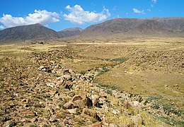
A dry gulch in the desert near Tamchy, Kyrgyzstan. The creek that may have run along the bottom of the gulch in the past has been diverted to a parallel aryk.
In xeric lands, a gulch is a deep V-shaped valley formed by erosion. It may contain a small stream or dry creek bed and is usually larger in size than a gully.[1] Sudden intense rainfall upstream may produce flash floods in the bed of the gulch.
In eastern Canada, gulch refers to:[2]
- a narrow deep cove (Newfoundland)
- a narrow saltwater channel (Nova Scotia)
See also[]
- Arroyo (creek) – Dry creek or stream bed with flow after rain
- Canyon – Deep ravine between cliffs, includes gorge.
- Dale (landform) – Open valley
- Coulee – Type of valley or drainage zone
- Gully – Landform created by running water and/or mass movement eroding sharply into soil
- Ravine – Small valley, which is often the product of streamcutting erosion
- Valley – Low area between hills, often with a river running through it
- Wadi – River valley, especially a dry riverbed that contains water only during times of heavy rain
- Draw (terrain)
References[]
- ^ "Dictionary of geological terms". American Geological Institute. 1976. p. 199.
a small revine; a small swallow cayon with smoothly included slopes and steep sides. Local in Far West
- ^ "Gulch". Interesting and curious generic terms used in Canada. Natural Resources Canada. Archived from the original on 26 September 2011. Retrieved 8 April 2013.

This article relating to topography is a stub. You can help Wikipedia by . |
Categories:
- Erosion landforms
- Fluvial landforms
- Canyons and gorges
- Valleys
- Topography stubs