Floodplain

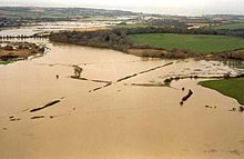


A floodplain or flood plain or bottomlands[1] is an area of land adjacent to a river which stretches from the banks of its channel to the base of the enclosing valley walls, and which experiences flooding during periods of high discharge.[2] The soils usually consist of clays, silts, sands, and gravels deposited during floods.[3]
Formation[]
Most floodplains are formed by deposition on the inside of river meanders and by overbank flow.[4]
Wherever the river meanders, the flowing water erodes the river bank on the outside of the meander, while sediments are simultaneously deposited in a point bar on the inside of the meander. This is described as lateral accretion, since the deposition builds the point bar laterally into the river channel. Erosion on the outside of the meander usually closely balances deposition on the inside of the meander, so that the channel shifts in the direction of the meander without changing significantly in width. The point bar is built up to a level very close to that of the river banks. Significant net erosion of sediments occurs only when the meander cuts into higher ground. The overall effect is that, as the river meanders, it creates a level flood plain composed mostly of point bar deposits. The rate at which the channel shifts varies greatly, with reported rates ranging from too slow to measure to as much as 2,400 feet (730 m) per year for the Kosi River of India.[5]
Overbank flow takes place when the river is flooded with more water than can be accommodated by the river channel. Flow over the banks of the river deposits a thin veneer of sediments on the floodplain that is coarsest and thickest close to the channel. This is described as vertical accretion, since the deposits build the floodplain upwards. In undisturbed river systems, overbank flow is a frequent occurrence, typically occurring every one to two years regardless of climate or topography.[6] Sedimentation rates for a three-day flood of the Meuse and Rhine Rivers in 1993 found average sedimentation rates in the floodplain of between 0.57 and 1.0 kg/m2. Higher rates were found on the levees (4 kg/m2 or more) and on low-lying areas (1.6 kg/m2).[7]
Sedimentation from overbank flow is concentrated on natural levees, crevasse splays, and in wetlands and shallow lakes of flood basins. Natural levees are ridges along river banks that form from rapid deposition from overbank flow. Most of the suspended sand is deposited on the levees, leaving the silt and clay sediments to be deposited as floodplain muds further from the river. Levees are typically build up enough to be relatively well-drained compared with nearby wetlands, and levees in non-arid climates are often heavily vegetated.[8]
Crevasses are formed by breakout events from the main river channel. The river bank fails and floodwaters scour a channel. Sediments from the crevasse spread out as delta-shaped deposits with numerous distributary channels. Crevasse formation is most common in sections of rivers where the river bed is accumulating sediments (aggrading).[9]
Repeated flooding eventually builds up an alluvial ridge, whose natural levees and abandoned meander loops may stand well above most of the floodplain.[10] The alluvial ridge is topped by a channel belt, formed by successive generations of channel migration and meander cutoff. At much longer intervals, the river may completely abandon the channel belt and begin building a new channel belt at another position on the floodplain. This process is called avulsion, and takes place at intervals of 10–1000 years. Historical avulsions leading to catastrophic flooding include the 1855 Yellow River flood and the 2008 Kosi River flood.[11]
Floodplains can form around rivers of any kind or size. Even relatively straight stretches of river are found to be capable of producing floodplains. Mid-channel bars in braided rivers migrate downstream through processes resembling those in point bars of meandering rivers and can build up a floodplain.[12]
The quantity of sediments in a floodplain greatly exceed the river load of sediments. Thus, floodplains are an important storage site for sediments during their transport from where they are generated to their ultimate depositional environment.[13]
When the rate at which the river is cutting downwards becomes great enough that overbank flows become infrequent, the river is said to have abandoned its floodplain, and portions of the abandoned floodplain may be preserved as fluvial terraces.[14]
Ecology []
Floodplains can support particularly rich ecosystems, both in quantity and diversity. Tugay forests form an ecosystem associated with floodplains, especially in Central Asia. They are a category of riparian zones or systems. A floodplain can contain 100 or even 1,000 times as many species as a river. Wetting of the floodplain soil releases an immediate surge of nutrients: those left over from the last flood, and those that result from the rapid decomposition of organic matter that has accumulated since then. Microscopic organisms thrive and larger species enter a rapid breeding cycle. Opportunistic feeders (particularly birds) move in to take advantage. The production of nutrients peaks and falls away quickly; however the surge of new growth endures for some time. This makes floodplains particularly valuable for agriculture. River flow rates are undergoing change following suit with climate change. This change is a threat to the riparian zones and other floodplain forests. These forests have over time synced their seedling deposits after the spring peaks in flow to best take advantage of the nutrient rich soil generated by peak flow.[15]
Flood control[]
This section needs additional citations for verification. (May 2018) |
This section needs attention from an expert in Civil engineering. (March 2019) |
Excluding famines and epidemics, some of the worst natural disasters in history[16] (measured by fatalities) have been river floods, particularly in the Yellow River in China – see list of deadliest floods. The worst of these, and the worst natural disaster (excluding famine and epidemics) were the 1931 China floods, estimated to have killed millions. This had been preceded by the 1887 Yellow River flood, which killed around one million people, and is the second-worst natural disaster in history.
The extent of floodplain inundation depends in part on the flood magnitude, defined by the return period.
In the United States the Federal Emergency Management Agency (FEMA) manages the National Flood Insurance Program (NFIP). The NFIP offers insurance to properties located within a flood prone area, as defined by the Flood Insurance Rate Map (FIRM), which depicts various flood risks for a community. The FIRM typically focuses on delineation of the 100-year flood inundation area, also known within the NFIP as the Special Flood Hazard Area.
Where a detailed study of a waterway has been done, the 100-year floodplain will also include the floodway, the critical portion of the floodplain which includes the stream channel and any adjacent areas that must be kept free of encroachments that might block flood flows or restrict storage of flood waters. Another commonly encountered term is the Special Flood Hazard Area, which is any area subject to inundation by the 100-year flood.[17] A problem is that any alteration of the watershed upstream of the point in question can potentially affect the ability of the watershed to handle water, and thus potentially affects the levels of the periodic floods. A large shopping center and parking lot, for example, may raise the levels of the 5-year, 100-year, and other floods, but the maps are rarely adjusted, and are frequently rendered obsolete by subsequent development.
In order for flood-prone property to qualify for government-subsidized insurance, a local community must adopt an ordinance that protects the floodway and requires that new residential structures built in Special Flood Hazard Areas be elevated to at least the level of the 100-year flood. Commercial structures can be elevated or flood proofed to or above this level. In some areas without detailed study information, structures may be required to be elevated to at least two feet above the surrounding grade.[18] Many State and local governments have, in addition, adopted floodplain construction regulations which are more restrictive than those mandated by the NFIP. The US government also sponsors flood hazard mitigation efforts to reduce flood impacts. California's Hazard Mitigation Program is one funding source for mitigation projects. A number of whole towns such as English, Indiana, have been completely relocated to remove them from the floodplain. Other smaller-scale mitigation efforts include acquiring and demolishing flood-prone buildings or flood-proofing them.
In some floodplains, such as the Inner Niger Delta of Mali, annual flooding events are a natural part of the local ecology and rural economy, allowing for the raising of crops through recessional agriculture. However, in Bangladesh, which occupies the Ganges Delta, the advantages provided by the richness of the alluvial soil of the floodplain are severely offset by frequent floods brought on by cyclones and annual monsoon rains. These extreme weather events cause severe economic disruption and loss of human life in the densely-populated region.

See also[]
- Flood-meadow, area of grassland or pasture beside a river, subject to seasonal flooding.
- Water-meadow, area of grassland or pasture beside a river, subject to controlled seasonal flooding.
- Crevasse splay – Sediment deposited on a floodplain by a stream which breaks its levees, sedimentary deposit formed when an overloaded stream breaks its levee.
- Red River Floodway – Artificial flood control channel in Manitoba, Canada as a good example of a floodway.
- Floodplain restoration
- Flood opening, a technique for mitigating the effects of flooding on structures, mandated in some regions.
References[]
- ^ "Archived copy". Archived from the original on 2021-06-14. Retrieved 2021-06-14.CS1 maint: archived copy as title (link)
- ^ Goudie, A. S., 2004, Encyclopedia of Geomorphology, vol. 1. Routledge, New York. ISBN 0-415-32737-7
- ^ Kovács, János (2013). "Flood Deposits". Encyclopedia of Natural Hazards. Encyclopedia of Earth Sciences Series: 325. doi:10.1007/978-1-4020-4399-4_137. ISBN 978-90-481-8699-0.
- ^ Wolman, M. Gordon; Leopold, Luna B. (1957). "River Flood Plains: Some Observations On Their Formation". U.S. Geological Survey Professional Paper. Professional Paper. 282-C: 87. doi:10.3133/pp282C.
- ^ Wolman & Leopold 1957, pp. 91-97.
- ^ Wolman & Leopold 1957, pp. 88-91.
- ^ Asselman, Nathalie E. M.; Middelkoop, Hans (September 1995). "Floodplain sedimentation: Quantities, patterns and processes". Earth Surface Processes and Landforms. 20 (6): 481–499. Bibcode:1995ESPL...20..481A. doi:10.1002/esp.3290200602.
- ^ Leeder, M. R. (2011). Sedimentology and sedimentary basins : from turbulence to tectonics (2nd ed.). Chichester, West Sussex, UK: Wiley-Blackwell. pp. 265–266. ISBN 9781405177832.
- ^ Leeder 2011, pp. 266-267.
- ^ Leeder 2011, pp. 267.
- ^ Leeder 2011, pp. 269-271.
- ^ Wolman & Leopold 1957, pp. 105-106.
- ^ Lewin, John (October 1978). "Floodplain geomorphology". Progress in Physical Geography: Earth and Environment. 2 (3): 408–437. doi:10.1177/030913337800200302. S2CID 220950870.
- ^ Wolman & Leopold 1957, p. 105.
- ^ Rood, Stewart B.; Pan, Jason; Gill, Karen M.; Franks, Carmen G.; Samuelson, Glenda M.; Shepherd, Anita (2008-02-01). "Declining summer flows of Rocky Mountain rivers: Changing seasonal hydrology and probable impacts on floodplain forests". Journal of Hydrology. 349 (3–4): 397–410. Bibcode:2008JHyd..349..397R. doi:10.1016/j.jhydrol.2007.11.012.
- ^ development, Jessica Karpilo holds a B. A. in Geography from the University of Denver She has written on the subjects of sustainable; Karpilo, maps our editorial process Jessica. "What Are the 10 Deadliest Disasters in World History?". ThoughtCo. Archived from the original on 2020-11-27. Retrieved 2020-11-30.
- ^ "44 CFR 59.1 - Definitions". LII / Legal Information Institute. Archived from the original on 2017-08-29. Retrieved 2017-01-13.
- ^ "44 CFR 60.3 - Flood plain management criteria for flood-prone areas". LII / Legal Information Institute. Archived from the original on 2017-08-29. Retrieved 2017-01-13.
Sources[]
- Powell, W. Gabe. 2009. Identifying Land Use/Land Cover (LULC) Using National Agriculture Imagery Program (NAIP) Data as a Hydrologic Model Input for Local Flood Plain Management. Applied Research Project, Texas State University. http://ecommons.txstate.edu/arp/296/
- This article incorporates text from a publication now in the public domain: Chisholm, Hugh, ed. (1911). "Flood Plain". Encyclopædia Britannica (11th ed.). Cambridge University Press.
External links[]
 Media related to Floodplains at Wikimedia Commons

| show Authority control |
|---|
- Floodplains
- Flood control
- Fluvial landforms
- Hydrology
- Wetlands