Airton
| Airton | |
|---|---|
 Airton | |
 Airton Location within North Yorkshire | |
| Population | 228 (Including Otterburn. 2011 census)[1] |
| OS grid reference | SD902592 |
| • London | 234 miles (377 km) |
| Civil parish |
|
| District | |
| Shire county | |
| Region | |
| Country | England |
| Sovereign state | United Kingdom |
| Post town | SKIPTON |
| Postcode district | BD23 |
| Dialling code | 01729 |
| Police | North Yorkshire |
| Fire | North Yorkshire |
| Ambulance | Yorkshire |
| UK Parliament | |

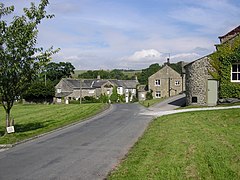
Airton (also known as Airton-in-Craven) is a small village and civil parish in the Craven district of North Yorkshire, England, situated 10 miles (16 km) north-west of Skipton. The village had a population of 175 according to the 2001 Census, increasing to 228 at the 2011 Census.[1]
History[]
Listed as Airtone in the Domesday Book,[2] the village takes its name from the River Aire which runs along its eastern edge.[3] In the late 1600s a significant Quaker community developed in the village around the Friends Meeting House.[4] In use for the majority of its history, this building was restored between 2010 and 2012[5] and continues to host an active Quaker meeting.
Other significant buildings in Airton include a squatter's cottage on the village green,[6] a former Methodist Chapel (now closed) and an old mill on the River Aire[7] which is in use as a private residence. The old mill was given listed status in 1989.[8] There is no pub or Post Office in the village; however there is a Farm Shop and Tea Room at Town End Farm on the road to Malham.[9]
Airton lies in the Ecclesiastical Parish of St. Michael and All Angels, Kirkby Malham.[10][11]
Transport[]
There is a bus stop in the village with daily links to Malham and Skipton. Also, the local roads link the village to the A65.
Tourism[]

The village is in the Yorkshire Dales National Park and lies on the tourist route to Malham Cove and Malham Tarn. The Pennine Way passes around the edge of the village, alongside the river.[12] The Way of the Roses cycle route passes through the village on the road between Settle and Grassington.
References[]
- ^ a b UK Census (2011). "Local Area Report – Airton Parish (1170216718)". Nomis. Office for National Statistics. Retrieved 23 March 2018.
- ^ "Airton". opendomesday.org. Retrieved 2 January 2016.
- ^ "Aighton - Akenham". www.british-history.ac.uk. Retrieved 2 January 2016.
- ^ Laurel, Phillipson. Hidden in plain sight : history and architecture of the Airton Meeting House. Armstrong, Alison (Alison C.). York. ISBN 9781904446774. OCLC 989576425.
- ^ "Quaker house appeal launched". Craven Herald. Retrieved 2 January 2016.
- ^ "The Green - Airton - North Yorkshire - England". www.britishlistedbuildings.co.uk. Retrieved 2 January 2016.
- ^ "Hydroelectricity in Malhamdale". www.kirkbymalham.info. Retrieved 2 January 2016.
- ^ "River Walk - Airton - North Yorkshire - England". www.britishlistedbuildings.co.uk. Retrieved 2 January 2016.
- ^ "Town End Farm Shop and Tearoom, Airton". Craven Herald. Retrieved 2 January 2016.
- ^ "Parishes Adjoining Kirkby in Malhamdale". www.kirkbymalham.info. Retrieved 2 January 2016.
- ^ "St Michael the Archangel Church, Kirkby Malham". kirkbymalhamchurch.org. Retrieved 2 January 2016.
- ^ "Pennine Way National Trail" (PDF). National Trail. Retrieved 2 January 2016.
External links[]
 Media related to Airton at Wikimedia Commons
- Village and area web site
- Airton history pages
- Airton in the Domesday Book
- Villages in North Yorkshire
- Civil parishes in North Yorkshire