North Yorkshire
North Yorkshire | |
|---|---|
Ceremonial county | |
 Coat of arms | |
 Location of North Yorkshire within England | |
| Sovereign state | United Kingdom |
| Constituent country | England |
| Region | Divided between Yorkshire and the Humber & North East |
| Established | 1974 |
| Established by | Local Government Act 1972 |
| Preceded by | North Riding of Yorkshire |
| Origin | Yorkshire |
| Time zone | UTC±00:00 (Greenwich Mean Time) |
| • Summer (DST) | UTC+01:00 (British Summer Time) |
| Members of Parliament | List of MPs |
| Police | North Yorkshire Police Cleveland Police |
| Ceremonial county | |
| Lord Lieutenant | Johanna Ropner[1] |
| High Sheriff | David Kerfoot (2020–21)[2] |
| Area | 8,608 km2 (3,324 sq mi) |
| • Ranked | 1st of 48 |
| Population (mid-2019 est.) | 1,158,816 |
| • Ranked | 14th of 48 |
| Density | 134/km2 (350/sq mi) |
| Ethnicity | 96% White 2.0% S.Asian 0.6% Black |
| Non-metropolitan county | |
| County council | North Yorkshire County Council (part) |
| Executive | Conservative |
| Admin HQ | Northallerton[3] |
| Area | 8,053 km2 (3,109 sq mi) |
| • Ranked | 1st of 26 |
| Population | 618,054 |
| • Ranked | 20th of 26 |
| Density | 77/km2 (200/sq mi) |
| ISO 3166-2 | GB-NYK |
| ONS code | 36 |
| NUTS | UKE22 |
| Districts | |
 Districts of North Yorkshire | |
| Districts | County districts: 1. Selby Unitary districts: |
North Yorkshire is the largest non-metropolitan county and lieutenancy area in England, covering an area of 8,654 square kilometres (3,341 sq mi). Around 40% of the county is covered by national parks, including most of the Yorkshire Dales and the North York Moors. It is one of four counties in England to hold the name Yorkshire; the three other counties are the East Riding of Yorkshire, South Yorkshire and West Yorkshire.
From 1974 (via Local Government Act 1972) to 1996, it was wholly within the Yorkshire and the Humber region. Since 1996, parts of the North East England region joined the county non-administratively. York also moved into being a non-administrative part of the county in 1996.[4]
The Middlesbrough built-up area (at 174,700) is the most populous settlement while the York built-up area is second with 152,841, although neither form part of the administrative county, not governed by North Yorkshire County Council. Mid-2016 estimates by the ONS recorded a 602,300 population in the county council area. The most populous settlement in the administrative county (and third in the overall ceremonial county) is Harrogate (at 75,070); followed by Scarborough (at 61,749). Northallerton, the administrative county town, was recorded with a 16,832 population.[5][6][7]
History[]
North Yorkshire was formed on 1 April 1974 as a result of the Local Government Act 1972, and covers most of the lands of the historic North Riding, as well as the northern parts of the West Riding as well as northern and eastern East Riding and the former county borough of York.
York became a unitary authority independent of county authority on 1 April 1996.[8] Middlesbrough, Redcar and Cleveland and Stockton borough south of the River Tees also became part of the county; these were part of Cleveland (county) for twenty two years from 1974 to 1996, and previously in the North Riding before that.
Geography[]

The geology of North Yorkshire is closely reflected in its landscape. Within the county are the North York Moors and most of the Yorkshire Dales; two of eleven areas of countryside within England and Wales to be officially designated as national parks. Between the North York Moors in the east and the Pennine Hills in the west lie the Vales of Mowbray and York. The Tees Lowlands lie to the north of the North York Moors and the Vale of Pickering lies to the south. Its eastern border is the North sea coast. The highest point is Whernside, on the Cumbrian border, at 736 metres (2,415 ft).[9]
The two major rivers in the county are the River Swale and the River Ure. The Swale and the Ure form the River Ouse which flows through York and into the Humber Estuary. The River Tees forms part of the border between North Yorkshire and County Durham and flows from upper Teesdale through Stockton-on-Tees and Middlesbrough and to the coast.
Green belt[]
North Yorkshire contains a small section of green belt in the south of the county, just north of Ilkley and Otley along the North and West Yorkshire borders. It extends to the east to cover small communities such as Huby, Kirkby Overblow, and Follifoot before covering the gap between the towns of Harrogate and Knaresborough, helping to keep those towns separate.
The belt meets with the Yorkshire Dales National Park at its southernmost extent, and also forms a border with the Nidderdale AONB. It extends into the western area of Selby district, reaching as far as Tadcaster and Balne. The belt was first drawn up from the 1950s.
The city of York has an independent surrounding belt area affording protections to several outlying settlements such as Haxby and Dunnington, and it too extends into the surrounding districts.
Climate[]
North Yorkshire has a temperate oceanic climate, like most of the UK. However, there are large climate variations within the county. The upper Pennines border on a Subarctic climate, whereas the Vale of Mowbray has an almost Semi-arid climate. Overall, with the county being situated in the east, it receives below-average rainfall for the UK, but the upper Dales of the Pennines are one of the wettest parts of England, where in contrast the driest parts of the Vale of Mowbray are some of the driest areas in the UK. Summer temperatures are above average, at 22 °C, but highs can regularly reach up to 28 °C, with over 30 °C reached in heat waves. Winter temperatures are below average, with average lows of 1 °C. Snow and Fog can be expected depending on location, with the North York Moors and Pennines having snow lying for an average of between 45 and 75 days per year.[10] Sunshine is most plentiful on the coast, receiving an average of 1650 hours a year, and reduces further west in the county, with the Pennines only receiving 1250 hours a year.
| hideClimate data for North Yorkshire | |||||||||||||
|---|---|---|---|---|---|---|---|---|---|---|---|---|---|
| Month | Jan | Feb | Mar | Apr | May | Jun | Jul | Aug | Sep | Oct | Nov | Dec | Year |
| Record high °C (°F) | 15 (59) |
17 (63) |
21 (70) |
24 (75) |
29 (84) |
32 (90) |
34 (93) |
33 (91) |
29 (84) |
28 (82) |
19 (66) |
16 (61) |
34 (93) |
| Average high °C (°F) | 6 (43) |
7 (45) |
10 (50) |
13 (55) |
16 (61) |
19 (66) |
22 (72) |
22 (72) |
18 (64) |
14 (57) |
10 (50) |
7 (45) |
14 (57) |
| Average low °C (°F) | 1 (34) |
1 (34) |
2 (36) |
4 (39) |
7 (45) |
10 (50) |
12 (54) |
12 (54) |
10 (50) |
7 (45) |
4 (39) |
1 (34) |
6 (43) |
| Record low °C (°F) | −14 (7) |
−10 (14) |
−13 (9) |
−3 (27) |
−1 (30) |
2 (36) |
5 (41) |
4 (39) |
−1 (30) |
−7 (19) |
−14 (7) |
−19 (−2) |
−19 (−2) |
| Average precipitation mm (inches) | 40 (1.6) |
35 (1.4) |
43 (1.7) |
46 (1.8) |
42 (1.7) |
47 (1.9) |
51 (2.0) |
59 (2.3) |
53 (2.1) |
62 (2.4) |
56 (2.2) |
59 (2.3) |
593 (23.3) |
| Source: [11][12] | |||||||||||||
Governance[]
Local authorities[]
| # | Local authority | 2011 census |
|---|---|---|
| – | Ceremonial county | 1,125,547 |
| – | Non-metropolitan county | 598,376 |
| 1 | York | 198,051[13] |
| 2 | Harrogate | 157,869[14] |
| 3 | Middlesbrough | 138,412[15] |
| 3 | Redcar and Cleveland | 135,177[16] |
| 4 | Scarborough | 108,793[17] |
| 5 | Hambleton | 89,140[18] |
| 6 | Selby | 83,449[19] |
| 7 | Stockton-on-Tees (south Tees) |
55,531[20] |
| 8 | Craven | 55,409[21] |
| 9 | Richmondshire | 51,965[22] |
| 10 | Ryedale | 51,751[23] |
By April 2023, the non-metropolitan county is set be reorganised into a unitary authority, the district and county councils are to merge with pre-existing unitary authorities un-altered.[24][25][26]
County[]

North Yorkshire County Council area is a non-metropolitan county in a cabinet-style council.[27] 72 councillors elect a council leader, who in turn appoints up to 9 councillors to form an executive cabinet. Offices for the county are in County Hall, Northallerton.
Districts[]

The county is divided into the local government districts of Craven, Hambleton, Harrogate, Richmondshire, Ryedale, Scarborough and Selby.[28]
Unitary authorities[]

Parts of the county are administered independently of the county council, having their own unitary authorities: the City of York Council, Redcar and Cleveland Borough Council, Middlesbrough Council and Stockton-on-Tees Borough Council. The latter three are part of the Tees Valley Combined Authority. Uniquely for England, the Borough of Stockton-on-Tees is split between North Yorkshire and County Durham.
Economy[]
In large areas of North Yorkshire, agriculture is the primary source of employment; some 85% of the county is considered to be "rural or super sparse".[29]
Other sectors in 2019 included some manufacturing, the provision of accommodation and meals (primarily for tourists) which accounted for 19 per cent of all jobs and food manufacturing which employed 11 per cent of workers; a few people are involved in forestry and fishing in 2019. The average weekly earnings in 2018 were £531. Some 15% of workers declared themselves as self-employed. One report in late 2020 stated that "North Yorkshire has a relatively healthy and diverse economy which largely mirrors the national picture in terms of productivity and jobs.[30][31]


Mineral extraction and power generation are also sectors of the economy as is high technology.[32]
Tourism is a significant contributor to the economy. A study of visitors between 2013 and 2015 indicated that the Borough of Scarborough, including Filey, Whitby and parts of the North York Moors National Park, received 1.4m trips per year on average.[33] A 2016 report by the National Park however, provides more impressive numbers: the park area gets 7.93 million visitors annually, generating £647 million and supporting 10,900 full-time equivalent jobs.[34]
The Yorkshire Dales have also attracted many visitors. In 2016, there were 3.8 million visits to the National Park including 0.48 million who stayed at least one night. The parks service estimates that this contributed £252 million to the economy and provided 3,583 full-time equivalent jobs. The wider Yorkshire Dales area received 9.7 million visitors who contributed £644 million to the economy.[35] The North York Moors and Yorkshire Dales are among England’s best known destinations.[36]


The North Yorkshire County Council operates many small tourist information offices in rural areas.[37] Nature or eco-tourism has become an important factor. In addition to hiking, some areas attract tourists with wildlife, although the latter aspect has yet to be fully developed.[38] Another agency promoting tourism to the region is the Herriot Country Tourism Group which covers the North York Moors and Yorkshire Dales as well as communities such as Thirsk, Northallerton, Easingwold, Great Ayton & Bedale.[39]
The historic towns of York and Harrogate are the top tourist destinations in the geographic area.[40] York attracts millions of visitors, some of whom may be enticed to continue northward to other areas of North Yorkshire. A 2014 report, based on 2012 data,[41] stated that York alone receives 6.9 million visitors annually; they contribute £564 million to the economy and support over 19,000 jobs.[42] In the 2017 Condé Nast Traveller survey of readers, York rated 12th among The 15 Best Cities in the UK for visitors.[43] In a 2020 Condé Nast Traveller report, York rated as the sixth best among ten "urban destinations [in the UK} that scored the highest marks when it comes to ... nightlife, restaurants and friendliness".[44]
During February 2020 to January 2021, the average property in North Yorkshire county sold for £240,000, up by £8100 over the previous 12 months. By comparison, the average for England and Wales was £314,000.[45] In certain communities of North Yorkshire, however, house prices were higher than average for the county, as of early 2021: Harrogate (average value: £376,195), Knaresborough (£375,625), Tadcaster (£314,278), Leyburn (£309,165) and Ripon (£299,998), for example.[46]
This is a chart of trend of regional gross value added for North Yorkshire at current basic prices with figures in millions of British pounds sterling.[47]
| Year | Regional Gross Value Added[Notes 1] | Agriculture[Notes 2] | Industry[Notes 3] | Services[Notes 4] |
|---|---|---|---|---|
| 1995 | 7,278 | 478 | 2,181 | 4,618 |
| 2000 | 9,570 | 354 | 2,549 | 6,667 |
| 2003 | 11,695 | 390 | 3,025 | 8,281 |
Effects of the pandemic[]
Unemployment in the county was traditionally low in recent years, but the lockdowns and travel restrictions necessitated by the COVID-19 pandemic had a negative effect on the economy during much of 2020 and into 2021.[48] The UK government said in early February 2021 that it was planning "unprecedented levels of support to help businesses [in the UK] survive the crisis".[49] A report published on 1 March 2021 stated that the unemployment rate in North Yorkshire had "risen to the highest level in nearly 5 years - with under 25s often bearing the worst of job losses".[50]
York experienced high unemployment during lockdown periods. One analysis (by the York and North Yorkshire Local Enterprise Partnership) predicted in August 2020 that "as many as 13,835 jobs in York will be lost in the scenario considered most likely, taking the city’s unemployment rate to 14.5%". Some critics claimed that part of the problem was caused by "over-reliance on the booming tourism industry at the expense of a long-term economic plan".[51] A report in mid June 2020 stated that unemployment had risen 114 per cent over the previous year because of restrictions imposed as a result of the pandemic.[52]
Tourism in the county was expected to increase after the restrictions imposed due the pandemic are relaxed. One reason for the expected increase is the airing of All Creatures Great and Small, a TV series about the vet James Herriot, based on a successful series of books; it was largely filmed within the Yorkshire Dales National Park.[53] The show aired in the UK in September 2020 and in the US in early 2021. One source stated that visits to Yorkshire websites had increased significantly by late September 2020.[54]
Gallery[]
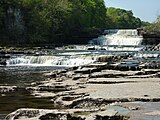
Aysgarth Falls, a popular destination for hikers, can also be reached by a short walk from the main road.

Leyburn is a gateway town to the Yorkshire Dales, offering tourists a range of Hotels, Pubs and Shops.
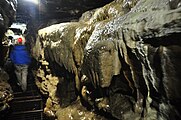
White Scar Cave is the largest cave in the United Kingdom.

In terms of interior floor area, York Minster is the 3rd Largest Cathedral in the United Kingdom.
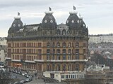
The Grand Hotel in Scarborough is a Grade II* listed building. At the time of its grand opening in 1867, it was the largest hotel and the largest brick structure in Europe.

With the first monastery built in the 7th-Century, the ruins of the Medieval Whitby Abbey still stand today, now famous for its role in Dracula.


Education[]
North Yorkshire LEA has a mostly comprehensive education system with 42 state schools secondary (not including sixth form colleges) and 12 independent schools.
Population[]
Map[]

Settlements and parishes[]
Settlements in italics lie within one of four unitary authorities.
| # | Place | Population (2011) |
Local authority | Defined as |
|---|---|---|---|---|
| 1 | Middlesbrough | 174,700[a] | Middlesbrough | Town |
| 2 | York | 152,841[b] | City of York | City |
| 3 | Harrogate | 73,576[c] | Harrogate | Town |
| 4 | Scarborough | 38,715[d] | Scarborough | Town |
| 5 | Redcar | 37,073[e] | Redcar and Cleveland | Town |
| 6 | Thornaby-on-Tees | 24,741[f] | Stockton-on-Tees (south) | Town |
| 7 | Ingleby Barwick | 20,378[66] | Stockton-on-Tees (south) | Town |
| 8 | Saltburn, Marske and New Marske | 19,134[67] | Redcar and Cleveland | Civil Parish |
| 9 | Guisborough | 17,777[68] | Redcar and Cleveland | Town |
| 10 | Ripon | 16,702[69] | Harrogate | City |
| 11 | Knaresborough | 15,441[70] | Harrogate | Town |
| 12 | Selby | 14,731[71] | Selby | Town |
| 13 | Skipton | 14,623[72] | Craven | Town |
| 14 | Whitby | 13,213[73] | Scarborough | Town |
| 15 | Skelton and Brotton | 12,848[74] | Redcar and Cleveland | Civil Parish |
| 16 | Northallerton | 10,655[g] | Hambleton | Town |
| 17 | Haxby | 8,428[76] | City of York | Town |
| 18 | Richmond | 8,413[77] | Richmondshire | Town |
| 19 | Yarm-on-Tees | 8,384[78] | Stockton-on-Tees (south) | Town |
| 20 | Loftus | 7,988[79] | Redcar and Cleveland | Town |
- ^ Based on its built-up area subdivision; including areas outside the council area.[55]
- ^ Based on its built-up area, excluding outlying towns and villages within the council area.[56]
- ^ Unparished built-up area subdivision accurately corresponds to town boundaries; no outlying areas.[57]
- ^ No population count measured the town independently at the 2011 census. Including parishes equates to 61,749, excluding outlying parishes of Eastfield,[58] Osgodby,[59] Cayton,[60] Newby, Scalby[61] and part of Seamer.[62] equates to total.
(approximate)
[63] - ^ Unparished built-up area subdivision accurately corresponds to town boundaries; no outlying areas.[64]
- ^ Built-up area subdivision accurately corresponds to town boundaries; no outlying areas.[65]
- ^ County town[75]
They are also multiple smaller settlements of North Yorkshire, italics denote a place in one of the unitary authorities apart from settlements of Middlesbrough:
- Acomb, Alne, Ampleforth, Appleton-le-Moors, Appleton Wiske
- Bedale, Bishopthorpe, Bolton, Boroughbridge, Borrowby (Hambleton), Borrowby (Scarborough), Brompton (Hambleton), Brotton, Buckden
- Castleton, Catterick, Catterick Garrison, Cawood, Clapham, Conistone, Copmanthorpe
- Dalton (Hambleton), Dalton (Richmondshire), Danby Wiske, Drax, Dunnington
- Easby, Easingwold, Egton, Elvington, Eston, Ebberston
- Filey, Folkton, Flixton
- Giggleswick, Gilling East, Gilling West, Glasshouses, Goathland, Grangetown, Grassington, Great Ayton, Grosmont, Guisborough, Ganton, Glaisdale
- Harrogate, Hawes, Haxby, Hebden, Helmsley, High Bentham, Hornton, Hunmanby, Huntington, Hutton Rudby
- Ingleton, Ingleby Arncliffe, Ingleby Barwick, Ingleby Greenhow
- Kettlewell, Kilnsey, Kirkbymoorside, Knaresborough
- Leyburn
- Malham, Malton, Masham, Marske-by-the-Sea, Middleham, Middlesbrough, Middleton, Ryedale, Muston
- New Marske, Normanby, Northallerton, Norton, North Grimston,
- Osmotherley, Ormesby
- Pateley Bridge, Pickering
- Raskelf, Redcar, Reeth, Riccall, Richmond, Rievaulx, Rillington, Ripon, Robin Hood's Bay, Romanby
- Saltburn, Scagglethorpe, Scampston, Scarborough, Scorton, Selby, Settle, Sherburn, Sheriff Hutton, Shipton, Skelton (Redcar and Cleveland), Skelton (Richmondshire), Skelton (York), Skinningrove, Skipton, Sowerby, Stillington, Stokesley, Streetlam, Sutton, Swinton
- Tadcaster, Teesville, Thirsk, Thornaby
- Whale Hill, Wheldrake, Whitby, Westow, Wintringham
- Yarm, York, Yedingham
Places of interest[]


| Key | |
| Abbey/Priory/Cathedral | |
| Accessible open space | |
| Amusement/Theme Park | |
| Castle | |
| Country Park | |
| English Heritage | |
| Forestry Commission | |
| Heritage railway | |
| Historic House | |
| Mosques | |
| Museum (free/not free) | |
| National Trust | |
| Theatre | |
| Zoo | |
Places of interest in italics lie are in the non-administrative county.
|
|
News and media[]
The county is served by BBC North East and Cumbria, and for more southerly parts of the county BBC Yorkshire. Yorkshire Television and Tyne Tees Television are also received in most areas of the county, Settle and the Western part of the Craven area is served by BBC North West and Granada Television. BBC Tees is broadcast to northern parts of the county, whilst BBC Radio York is broadcast more widely. BBC Radio Leeds broadcasts to southern parts of the county.
Transport[]
Rail[]


The East Coast Main Line (ECML) bisects the county stopping at Northallerton, Thirsk and York. Passenger services on the ECML within the county are operated by London North Eastern Railway, TransPennine Express and Grand Central. TransPennine Express run services on the York to Scarborough Line and the Northallerton–Eaglescliffe Line (for Middlesbrough) that both branch off the ECML.
Northern operates the remaining lines in the county, including commuter services on the Harrogate Line, Airedale Line and York & Selby Lines, of which the former two are covered by the Metro ticketing area. Remaining branch lines operated by Northern include the Yorkshire Coast Line from Scarborough to Hull, the Hull to York Line via Selby, the Tees Valley Line from Darlington to Saltburn and the Esk Valley Line from Middlesbrough to Whitby. Last but certainly not least, the Settle-Carlisle Line runs through the west of the county, with services again operated by Northern.

The county suffered badly under the Beeching cuts of the 1960s. Places such as Richmond, Ripon, Tadcaster, Helmsley, Pickering and the Wensleydale communities lost their passenger services. Notable lines closed were the Scarborough and Whitby Railway, Malton and Driffield Railway and the secondary main line between Northallerton and Harrogate via Ripon. Heritage railways within North Yorkshire include: the North Yorkshire Moors Railway, between Pickering and Grosmont, which opened in 1973; the Derwent Valley Light Railway near York; and the Embsay and Bolton Abbey Steam Railway. The Wensleydale Railway, which started operating in 2003, runs services between Leeming Bar and Redmire along a former freight-only line. The medium-term aim is to operate into Northallerton station on the ECML, once an agreement can be reached with Network Rail. In the longer term, the aim is to reinstate the full line west via Hawes to Garsdale on the Settle-Carlisle line.
York railway station is the largest station in the county, with 11 platforms and is a major tourist attraction in its own right. The station is immediately adjacent to the National Railway Museum.
Road[]
The main road through the county is the north–south A1(M), which has gradually been upgraded in sections to motorway status since the early 1990s. The only other motorways within the county are the short A66(M) near Darlington and a small stretch of the M62 motorway close to Eggborough.[28] The other nationally maintained trunk routes are the A168/A19, A64, A66 and A174.
Coach and bus
Long-distance coach services are operated by National Express and Megabus. Local bus service operators include Arriva Yorkshire, Harrogate Bus Company, Scarborough & District (East Yorkshire Motor Services), Yorkshire Coastliner, First York and the local Dales & District.
Air[]
There are no major airports in the county itself, but nearby airports include Teesside International (Darlington), Newcastle, Doncaster Sheffield and Leeds Bradford.
Sport[]
Cricket[]
Yorkshire County Cricket Club play a number of fixtures at North Marine Road, Scarborough. The ball game Rock-It-Ball was developed in the county.
Association football[]

North Yorkshire has multiple association football clubs:
|
Middlesbrough are currently the highest-ranked team in the county as they play in the EFL Championship. In the past, they have won the EFL Cup and reached the UEFA Cup final. Harrogate Town play in the EFL League Two. York City play in the National League North and finished 2nd on points-per-game during the 2019–20 season, but they lost their play-off semi-final to Altrincham. Whitby Town have reached the FA Cup first round seven times and have played the likes of Hull City, Wigan Athletic and Plymouth Argyle; they currently play in the Northern Premier League Premier Division, along with nearby Scarborough Athletic, a phoenix club of Scarborough.
Rugby football[]
| League | Team | Venue | Capacity | Location |
|---|---|---|---|---|
| National League 2 North | Harrogate | Rudding Lane | Harrogate | |
| Wharfedale | The Avenue | 2,000 | Threshfield, Craven | |
| North Premier | York | Clifton Park | York, North Yorkshire | |
| North 1 East | Malton & Norton | The Gannock | Malton | |
| Scarborough | Silver Royd | 4,500 (425 seats) | Scalby, Scarborough | |
| Yorkshire 1 | Selby | Sandhill Lane | Selby | |
| Durham & Northumberland 1 | Acklam | Talbot Park | Acklam, Middlesbrough | |
| Middlesbrough | Acklam Park | 5,000 (159 seats) | Acklam, Middlesbrough |
The leading rugby union teams in the county include Wharfedale RUFC, Harrogate RUFC, but teams also include Middlesbrough RUFC and Acklam RUFC who play their league games in Durham/Northumberland 1. York City Knights, previously known as York F.C., are a rugby league team who play in the Rugby League Championships.
Racing[]
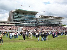
North Yorkshire has multiple racecourses at: Catterick Bridge, Redcar, Ripon, Thirsk and York. It also has one motor racing circuit, Croft Circuit; the circuit holds meetings of the British Touring Car Championship, British Superbike and Pickup Truck Racing race series and one Motorcycle Racing Circuit at Oliver's Mount, Scarborough.
See also[]
- List of Lords Lieutenant of North Yorkshire
- List of High Sheriffs of North Yorkshire
- North Yorkshire Police
- North Yorkshire Police and Crime Commissioner
Notes[]
References[]
- ^ "New Lord-Lieutenant of North Yorkshire appointed". Gazette & Herald. 13 November 2018. Retrieved 14 November 2018.
- ^ "No. 62943". The London Gazette. 13 March 2020. p. 5161.
- ^ "North Yorkshire County Council : Contact us". www.northyorks.gov.uk. Archived from the original on 18 April 2009. Retrieved 16 May 2009.
- ^ Arnold-Baker, C., Local Government Act 1972, (1973)
- ^ "North Yorkshire population information". North Yorkshire County Council. 30 November 2017. Archived from the original on 15 July 2018. Retrieved 15 July 2018.
- ^ UK Census (2011). "Local Area Report – Scarborough Built-up area (E34004408)". Nomis. Office for National Statistics. Retrieved 14 August 2021.
- ^ UK Census (2011). "Local Area Report – York Built-up area sub division (1119883765)". Nomis. Office for National Statistics. Retrieved 12 August 2018.
- ^ "The North Yorkshire (District of York) (Structural and Boundary Changes) Order 1995". OPSI. 10 July 2006. Archived from the original on 10 July 2006.
- ^ "The County Tops". The Relative Hills of Britain. 26 July 2012. Archived from the original on 26 July 2012.
- ^ "Regional mapped climate averages". The Met Office. Archived from the original on 29 December 2010. Retrieved 27 September 2010.
- ^ "UK mapped climate averages". The Met Office. Archived from the original on 30 December 2010. Retrieved 27 September 2010.
- ^ "Temperature of −19C is new Yorkshire record". BBC News Online. BBC. 3 December 2010. Archived from the original on 6 December 2010. Retrieved 4 December 2010.
- ^ "York Local Authority". Retrieved 16 March 2020.
- ^ "Harrogate Local Authority". Retrieved 16 March 2020.
- ^ "Middlesbrough Local Authority". Retrieved 16 March 2020.
- ^ "Redcar and Cleveland Local Authority". Retrieved 16 March 2020.
- ^ "Scarborough Local Authority". Retrieved 16 March 2020.
- ^ "Hambleton Local Authority". Retrieved 16 March 2020.
- ^ "Selby Local Authority". Retrieved 16 March 2020.
- ^ Parishes:
- 293, "Maltby Parish". Retrieved 16 March 2020.
- 374, "Hilton Parish". Retrieved 16 March 2020.
- 1,361, "Kirklevington Parish". Retrieved 16 March 2020.
- 8,384, "Yarm Parish". Retrieved 16 March 2020.
- 20,378, "Ingleby Barwick Parish". Retrieved 16 March 2020.
- 24,741, "Thornaby Parish". Retrieved 16 March 2020.
- ^ "Craven Local Authority". Retrieved 16 March 2020.
- ^ "Richmondshire Local Authority". Retrieved 16 March 2020.
- ^ "Ryedale Local Authority". Retrieved 16 March 2020.
- ^ "North Yorkshire councils scrapped and replaced with one authority". BBC News. 21 July 2021. Retrieved 13 August 2021.
- ^ "Government backs bid for single unitary authority to replace North Yorkshire councils including Harrogate". www.harrogateadvertiser.co.uk. Retrieved 4 August 2021.
- ^ "Next steps for new unitary councils in Cumbria, North Yorkshire and Somerset". GOV.UK. Retrieved 4 August 2021.
- ^ "North Yorkshire County Council Constitution". North Yorkshire County Council. Archived from the original on 28 December 2010. Retrieved 10 May 2010.
- ^ Jump up to: a b "Transport map of shire county divided into districts". North Yorkshire County Council. Archived from the original (PDF) on 7 August 2011. Retrieved 10 October 2008.
- ^ Independent commission hears evidence on how North Yorkshire's rural economy can achieve its potential
- ^ Jobs and the economy – North Yorkshire’s Rural Commission calls for evidence
- ^ Rural study group to look at farming and tourism jobs and the North Yorkshire economy
- ^ "North Yorkshire population information". North Yorkshire County Council. 19 December 2013. Archived from the original on 7 August 2013. Retrieved 17 January 2014.
- ^ "Region's coast 'top tourist draw'". BBC News. 7 June 2016. Archived from the original on 27 September 2018. Retrieved 14 July 2018.
- ^ "Tourism: North York Moors National Park". Archived from the original on 30 June 2017. Retrieved 14 July 2018.
- ^ "Trends in tourism in the Yorkshire Dales 2010 to 2016" (PDF). Archived from the original (PDF) on 14 July 2018. Retrieved 14 July 2018.
- ^ "Growing the Visitor Economy of North Yorkshire's Protected Landscapes" (PDF). Archived (PDF) from the original on 15 July 2018. Retrieved 14 July 2018.
- ^ "North Yorkshire tourist information". North Yorkshire County Council. 9 November 2017. Archived from the original on 15 July 2018. Retrieved 14 July 2018.
- ^ "North Yorkshire nature tourism can boost the economy by millions of pounds, report claims". The Yorkshire Post. Archived from the original on 15 July 2018. Retrieved 14 July 2018.
- ^ "Welcome to Herriot Country". Yorkshire.com. 18 November 2020. Retrieved 1 March 2021.
- ^ "Tourism and Travel – Leisure, Sport & Tourism – Yorkshire Employment and Training Information". Yorkshire Graduates. Archived from the original on 15 July 2018. Retrieved 14 July 2018.
- ^ "Tourists spend more than £600m". BBC. 11 February 2014. Archived from the original on 12 July 2018. Retrieved 27 June 2018.
- ^ "Report" (PDF). VisitYork. Archived (PDF) from the original on 27 June 2018. Retrieved 27 June 2018.
- ^ Traveller, Condé Nast. "The best cities in the UK". www.cntraveller.com. Archived from the original on 27 June 2018. Retrieved 27 June 2018.
- ^ THE BEST CITIES IN THE UK 2020 7 October 2020
- ^ North Yorkshire property prices
- ^ Top most expensive places to live in North Yorkshire 24 January 2021
- ^ "Regional Gross Value Added" (PDF). Office for National Statistics. 21 December 2005. pp. 240–253. Archived from the original (PDF) on 1 December 2007. Retrieved 6 October 2008.
- ^ North Yorkshire County Council facing 'toughest decision ever' over tax bills 7 January 2021
- ^ Covid: Lockdown cost Yorkshire economy £8bn, report says 4 February 2021
- ^ uncertainty for North Yorkshire's 'lost generation' Bauer Radio Ltd
- ^ Halliday, Josh (2 August 2020). "'No one expected this': York at crossroads as coronavirus takes toll". The Guardian. Retrieved 2 March 2021.
- ^ "'Toughest time in living memory' - unemployment up 141 in York". York Press. Retrieved 2 March 2021.
- ^ "Insider's Guide to the Yorkshire Dales Filming Locations". PBS Masterpiece. 24 January 2021. Retrieved 27 February 2021.
- ^ "New All Creatures Great and Small brings a huge increase in Yorkshire tourism". Examiner. 24 September 2020. Retrieved 27 February 2021.
- ^ UK Census (2011). "Local Area Report – Middlesbrough Built-up area sub dividion (E35001385)". Nomis. Office for National Statistics. Retrieved 23 February 2020.
- ^ UK Census (2011). "Local Area Report – York Built-up area sub division (E35000051)". Nomis. Office for National Statistics. Retrieved 23 February 2020.
- ^ UK Census (2011). "Local Area Report – Harrogate Built-up area sub division (E35000975)". Nomis. Office for National Statistics. Retrieved 23 February 2020.
- ^ UK Census (2011). "Local Area Report – Eastfield Parish (E04007709)". Nomis. Office for National Statistics. Retrieved 23 February 2020.
- ^ UK Census (2011). "Local Area Report – Osgodby Parish (E04007694)". Nomis. Office for National Statistics. Retrieved 23 February 2020.
- ^ UK Census (2011). "Local Area Report – Cayton Parish (E04007663)". Nomis. Office for National Statistics. Retrieved 23 February 2020.
- ^ UK Census (2011). "Local Area Report – Newby and Scalby Parish (E04007691)". Nomis. Office for National Statistics. Retrieved 23 February 2020.
- ^ UK Census (2011). "Local Area Report – Seamer Parish (E04007697)". Nomis. Office for National Statistics. Retrieved 23 February 2020.
- ^ UK Census (2011). "Local Area Report – Scarborough Built-up area (E34004408)". Nomis. Office for National Statistics. Retrieved 23 February 2020.
- ^ UK Census (2011). "Local Area Report – Redcar Built-up area sub division (E35000002)". Nomis. Office for National Statistics. Retrieved 23 February 2020.
- ^ UK Census (2011). "Local Area Report – Thornaby-on-Tees Built-up area sub division) (E35001481)". Nomis. Office for National Statistics. Retrieved 23 February 2020.
- ^ UK Census (2011). "Local Area Report – Ingleby Barwick Parish (E04000275)". Nomis. Office for National Statistics. Retrieved 23 February 2020.
- ^ UK Census (2011). "Local Area Report – Saltburn, Marske and New Marske Parish (E04000266)". Nomis. Office for National Statistics. Retrieved 23 February 2020.
- ^ UK Census (2011). "Local Area Report – Guisborough Parish (E04000263)". Nomis. Office for National Statistics. Retrieved 23 February 2020.
- ^ UK Census (2011). "Local Area Report – Ripon Parish (E04007409)". Nomis. Office for National Statistics. Retrieved 23 February 2020.
- ^ UK Census (2011). "Local Area Report – Knaresborough Parish (E04007372)". Nomis. Office for National Statistics. Retrieved 23 February 2020.
- ^ UK Census (2011). "Local Area Report – Selby Parish (E04007765)". Nomis. Office for National Statistics. Retrieved 23 February 2020.
- ^ UK Census (2011). "Local Area Report – Skipton Parish (E04007117)". Nomis. Office for National Statistics. Retrieved 23 February 2020.
- ^ UK Census (2011). "Local Area Report – Whitby Parish (E04007706)". Nomis. Office for National Statistics. Retrieved 23 February 2020.
- ^ UK Census (2011). "Local Area Report – Skelton and Brotton Parish (E04000267)". Nomis. Office for National Statistics. Retrieved 23 February 2020.
- ^ UK Census (2011). "Local Area Report – Northallerton Parish (E04007234)". Nomis. Office for National Statistics. Retrieved 23 February 2020.
- ^ UK Census (2011). "Local Area Report – Haxby Parish (E04000603)". Nomis. Office for National Statistics. Retrieved 23 February 2020.
- ^ UK Census (2011). "Local Area Report – Richmond Parish (E04007520)". Nomis. Office for National Statistics. Retrieved 23 February 2020.
- ^ UK Census (2011). "Local Area Report – Yarm Parish (E04012074)". Nomis. Office for National Statistics. Retrieved 23 February 2020.
- ^ UK Census (2011). "Local Area Report – Loftus Parish (E04000265)". Nomis. Office for National Statistics. Retrieved 23 February 2020.
External links[]
| Look up North Yorkshire in Wiktionary, the free dictionary. |
| Wikimedia Commons has media related to North Yorkshire. |
| Wikivoyage has a travel guide for North Yorkshire. |
- North Yorkshire Lieutenancy
- North Yorkshire County Council
- North Yorkshire at Curlie
- Images of North Yorkshire at the English Heritage Archive
| show |
|---|
| show Districts of Yorkshire and the Humber |
|---|

| show Authority control |
|---|
Coordinates: 54°10′N 1°20′W / 54.167°N 1.333°W

- North Yorkshire
- Counties of England established in 1974
- Non-metropolitan counties