North Riding of Yorkshire
| County of York, North Riding | |
|---|---|
 Flag of North Riding (2013) | |
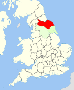 North Riding shown within England | |
| Area | |
| • 1911 | 1,359,600 acres (5,502 km2) |
| • 1961 | 1,376,607 acres (5,570.93 km2) |
| Population | |
| • 1901 | 286,036 |
| • 1971 | 329,410 |
| History | |
| • Created | Ancient (as a county in 1889) |
| • Abolished | 1974 |
| • Succeeded by | North Yorkshire Cleveland (1974-1996) County Durham |
| Status | Riding then Administrative county |
| Chapman code | NRY |
| Government | North Riding County Council (1889–1974) |
| • HQ | Northallerton |
 Coat of arms of North Riding County Council | |
The North Riding of Yorkshire is a subdivision of Yorkshire, England, alongside York, the East Riding and West Riding. The riding's highest point is at Mickle Fell with 2,585 ft (788 metres).
From the Restoration it was used as a lieutenancy area, having been previously part of the Yorkshire lieutenancy. Each riding was treated as a county for many purposes, such as quarter sessions. An administrative county, based on the riding, was created with a county council in 1889 under the Local Government Act 1888. In 1974 both the administrative county and the North Riding of Yorkshire lieutenancy were abolished, replaced in most of the riding by the non-metropolitan county and lieutenancy of North Yorkshire.
History[]
Archives from 1808 record that the "north-riding of York-shire" had once consisted of "fifty-one lordships" owned by Robert the Bruce.[1] During the English Civil War, the North Riding predominantly supported the royalist cause, while other areas of Yorkshire tended to support the parliamentarians.[2]
Governance and administration[]
The County of York, North Riding administrative county was formed in 1889. In 1894 it was divided into municipal boroughs, urban districts and rural districts under the Local Government Act 1894. Middlesbrough had already been incorporated as a municipal borough in 1853 and formed a county borough, exempt from county council control, from 1889. Richmond and Scarborough had been incorporated as municipal boroughs in 1835, with Thornaby-on-Tees added in 1892.
The urban districts in 1894 were Eston, Guisborough, Hinderwell, Kirkleatham, Kirklington cum Upsland, Loftus, Malton, Masham, Northallerton, Pickering, Redcar, Saltburn and Marske by the Sea, Scalby, Skelton and Brotton and Whitby. In 1922 Redcar was incorporated as a borough.
The rural districts in 1894 were Aysgarth, Bedale, Croft, Easingwold, Flaxton, Guisborough, Helmsley, Kirkby Moorside, Leyburn, Malton, Masham, Middlesbrough, Northallerton, Pickering, Reeth, Richmond, Scarborough, Startforth, Stokesley, Thirsk, Wath and Whitby.
County Review Orders reduced the number of urban and rural districts in the county:[3]
- Hinderwell urban district was absorbed by Whitby rural district in 1932
- A new Saltburn and Marske by the Sea urban district was formed from Saltburn by the Sea urban district and part of Guisborough rural district. the remainder of Guisborough RD passed to Loftus urban district and Whitby rural district in 1932
- Kirklington cum Upsland urban district was absorbed by Bedale rural district in 1934
- Masham urban district was redesignated as Masham rural district in 1934
In 1968 a new Teesside county borough was created, taking in Middlesbrough and parts of the administrative areas of Durham and North Riding councils. From the North Riding came the Redcar Borough and Saltburn-Marske Urban District, Thornaby-on-Tees Borough (formerly part of the Stokesley's rural district) and Eston's urban district. Tees-Side also included parts north of the River Tees historically in Durham. The area was associated with the North Riding for lieutenancy and other purposes.
Sub-cultural area[]
In 1974 the North Riding authorities were abolished. The majority of its former area became part of a North Yorkshire administrative area. This area includes a northern part of the West Riding as well as the northern and western parts of the pre-1974 East Riding. Land in and around the former Teesside county borough became part of Cleveland county.
In 1996, Cleveland county was abolished with Middlesbrough, Redcar-and-Cleveland and a part of the Stockton district assigned to the North Yorkshire lieutenancy, becoming known as a similarly named conurbation to the previous county borough called Teesside. The City of York borough also became a unitary authority. The former Startforth Rural District (remaining land south of the Tees) is the only part of the North Riding outside of the North Yorkshire lieutenancy since 1974, under County Durham Council area and until 2009 in areas .
The North Riding is now represented by all of Hambleton, Richmondshire, Ryedale, Scarborough, Middlesbrough, Redcar and Cleveland. It is also represented by parts of Harrogate, Stockton-on-Tees, City of York and County Durham council area.
The principal towns of the cultural and historic riding are Middlesbrough, Redcar, Whitby, Scarborough and Northallerton.[4]
Proposed resurrection of name[]
On three occasions a re-use of the name of the North Riding for local government purposes has been considered. During the 1990s UK local government reform, the Banham Commission suggested uniting Richmondshire, Hambleton, Ryedale and Scarborough districts in a new unitary authority called North Riding of Yorkshire. Later, the government proposed renaming the ceremonial county of North Yorkshire the North Riding of Yorkshire.[5] This was deemed inappropriate and rejected, after a "chorus of disapprobation".[6][7]
During a further local government review in the 2000s as part of the preparations for the regional assembly referendums, a unitary authority with the name North Riding of Yorkshire, consisting of Richmondshire, Hambleton, Ryedale and Scarborough was again suggested.[8] However, the Commission withdrew this in favour or two unitary authorities, one for Hambleton and Richmondshire, the other for Ryedale and Scarborough.[9]
Ancient divisions[]
Unlike most counties in England, which were divided anciently into hundreds, Yorkshire was divided first into three ridings and then into numerous wapentakes within each riding. Within the North Riding of Yorkshire there were thirteen wapentakes in total, as follows:
Wapentakes[]
 |
See also[]
- List of Lord Lieutenants of the North Riding
- List of High Sheriffs of North Yorkshire
- Custos Rotulorum of the North Riding of Yorkshire – List of Keepers of the Rolls
References[]
- ^ Graves, J. (1808). The History of Cleveland, in the North Riding of the County of York: Comprehending an Historical and Descriptive View of the Ancient and Present State of Each Parish Within the Wapontake of Langbargh; the Soil, Produce, and Natural Curiosities; with the Origin and Genealogy of the Principal Families Within the District. F. Jollie and sons. p. 55. Retrieved 13 June 2020.
Robert de Brus...and fifty-one [lordships] in the north-riding of York-shire;....
- ^ "Historic Cleveland – Timeline". Historic-Cleveland.co.uk. Archived from the original on 30 November 2007. Retrieved 4 October 2007.
- ^ The North Riding of York (Northern Areas) Order 1932, The North Riding of York Review Order 1934
- ^ F. R. Youngs, Local Administrative Units of England, Vol.II, Northern England, London, 1991
- ^ "House of Commons Written Answers to Questions". Parliamentary Debates (Hansard). House of Commons. 1 February 1995. col. 694.
- ^ "House of Commons Written Answers to Questions". Parliamentary Debates (Hansard). House of Commons. 13 February 1995. col. 552.
- ^ "House of Commons Debates". Parliamentary Debates (Hansard). House of Commons. 28 February 1995. col. 993.
- ^ The Boundary Committee for England (December 2003). Draft Recommendations for unitary local government in North Yorkshire (PDF). Archived (PDF) from the original on 19 January 2018. Retrieved 19 January 2018.
- ^ The Boundary Committee for England (May 2004). Final Recommendations for unitary local government in North Yorkshire (PDF). Archived (PDF) from the original on 19 January 2018. Retrieved 19 January 2018.
External links[]
- Map of the North Riding of Yorkshire on Wikishire
- Information on the North Riding of Yorkshire on I'm From Yorkshire
| Ceremonial counties |
|
|---|---|
| Historic divisions |
|
| Geography | |
| History |
|
| Culture and heritage | |
| |
Coordinates: 54°20′16″N 1°25′43″W / 54.33778°N 1.42861°W

- North Riding of Yorkshire
- History of local government in Yorkshire
- Geography of North Yorkshire
- History of North Yorkshire
- Local government in North Yorkshire
- Administrative counties abolished in 1974