Ajloun
Ajloun
عجلون | |
|---|---|
Town | |
 City of Ajloun from Ajloun Castle | |
| Nickname(s): Jordan Green | |
 Ajloun Location in Jordan | |
| Coordinates: Coordinates: 32°19′57″N 35°45′06″E / 32.33250°N 35.75167°E | |
| Grid position | 221/193 |
| Country | |
| Governorate | Ajloun |
| Municipality established | 1920 |
| Area | |
| • Town | 4 km2 (2 sq mi) |
| • Metro | 30 km2 (10 sq mi) |
| Elevation | 719 m (2,508 ft) |
| Population (2015 [1]) | |
| • Town | 148,870 |
| • Metro | 190,200 |
| Time zone | UTC+2 (GMT) |
| • Summer (DST) | +3 |
| Area code(s) | +(962)2 |
| Website | http://www.ajloun.gov.jo |

Ajloun (Arabic: عجلون, ‘Ajlūn), also spelled Ajlun, is the capital town of the Ajloun Governorate, a hilly town in the north of Jordan, located 76 kilometers (around 47 miles) north west of Amman. It is noted for its impressive ruins of the 12th-century Ajloun Castle.
The Ajlun Governorate has a population of over 176,080 widespread in 27 villages and towns over an area of about 420 km². The population is mainly composed of the following Muslim tribes: Al-Qudah (AlQudah , Al-Share, Al-Zghoul, Al-Momani, Al-Smadi, Al-Shwayyat, Al-Freihat, Al-Khatatbah, Alnawateer, Al-Karraz, and others. Muqattash, Haddad, Iwais, Eisouh and Rabadi are the main Christian tribes in Ajloun. Although Christians are a minority in the overall governorate, they form about more than half of the population in Ajloun city; most Christians reside in Ajloun city along with Muslims of the Al-Smadi tribe. Other tribes are distributed in the other districts of the governorate. Ajloun Governorate has four seats in the national parliament, one of which is dedicated for the Christian minority.
Districts of Metropolitan Ajloun[]
There are five districts in the Greater Ajloun Municipality:

| District | |
|---|---|
| 1 | Ajloun |
| 2 | Ain Janna |
| 3 | Anjara |
| 4 | ِSakhra |
| 5 | Rawabi |
| 6 | Khet Al-Laban |
| 7 | Orjan
Kufranjeh |
History[]
In 1596, during the Ottoman Empire, Ajloun was noted in the census as being located in the nahiya of Ajloun in the liwa of Ajloun. It had a population of 313 Muslim households, and 20 Muslim bachelors, in addition to 20 Christian households. They paid taxes on various agricultural products, including olive trees, vineyards, fruit trees, vegetables and fruit garden, orchards, bayt al-mal wa mal ga'ib, goats and beehives, in addition to occasional revenues; a market toll and water mill; a total of 14,500 akçe.[2]
In 1838 Ajloun's inhabitants were predominantly Sunni Muslims and Greek Christians.[3]
The Jordanian census of 1961 found 5390 inhabitants in Ajloun,[4] of whom 2023 were Christians.[5]
Demographics[]
According to the Jordan national census of 2015, the population of the town of Ajloun was 9990. For Ajloun Governorate as a whole, the population was about 176,080 in 2015. Muslims make up the majority of Ajloun's population. They live alongside the indigenous Christian population. The governorate of Ajloun is highly agricultural, as the population distribution tells.
Geography[]
There is a theory that the town's name is connected with the Moabite King Eglon mentioned in the Bible, though the precise derivation is obscure.

Ajlun Castle is located on the site of an old monastery. It was renovated as a fort in 1184 by Izz al-Din Usama, a general in the army of Saladin. The castle controlled traffic along the road connecting Damascus and Egypt. The fortress marks the furthest limit of Frankish incursions during the Crusades. The Mamluks added a prominent tower to the castle. It was captured by the Mongols in 1260 and was partially destroyed in the process. Great damage was done by the Galilee earthquake of 1837 and the 1927 Jericho earthquake.[6]
Located in the center of Ajloun is the Great Ajlun Mosque. This mosque is one of the oldest extant in Jordan and dates back around 800 years. This edifice was previously a Byzantine Christian church; there have been reports of Greek writing in the oldest sections. The prayer tower is called "the filter" by some locals (referring to a cigarette filter, because half of the tower was built over a square tower, most likely a Church bell tower). In 2007 work began on improving the mosque to allow tourists to visit it. There are also reports that when the west wall fell apart in the heavy rains and snow in January 2013 a Bible and crosses were found in the old section.
Tell Mar Elias is located just outside the city limits. This site contains Byzantine church mosaics which were uncovered during the summer months for tourists. T tohis location for Saint Elijah (Mar Elias) has been a shrine for centuries – people would go there and walk around the shrine singing ancient songs to cure a disease called "Rigeh". There are folk songs they sang for this visit. However, prior to the Pope's visit in 2000. A scholar on both Mar Elias and Ajlun Castle is Mohammad Abu-Abeileh in Jordan.
The Ajloun Forest Reserve is also located nearby. The whole area had been reputed to be the largest forested area in the Middle East – however, the area was largely deforested by the Turks to secure fuel for their railroad to Mecca.
Climate[]
Ajloun, has a mediterranean climate (Köppen climate classification: Csa). The average annual temperature is 16.7 °C (62.1 °F), and around 467 mm (18.39 in) of precipitation falls annually.
| hideClimate data for Ajloun | |||||||||||||
|---|---|---|---|---|---|---|---|---|---|---|---|---|---|
| Month | Jan | Feb | Mar | Apr | May | Jun | Jul | Aug | Sep | Oct | Nov | Dec | Year |
| Average high °C (°F) | 11.6 (52.9) |
12.8 (55.0) |
15.5 (59.9) |
20.5 (68.9) |
25.8 (78.4) |
28.6 (83.5) |
29.8 (85.6) |
29.9 (85.8) |
28.5 (83.3) |
25.5 (77.9) |
19.9 (67.8) |
13.6 (56.5) |
21.8 (71.3) |
| Daily mean °C (°F) | 7.8 (46.0) |
8.7 (47.7) |
10.8 (51.4) |
15.0 (59.0) |
19.7 (67.5) |
22.6 (72.7) |
24.2 (75.6) |
24.5 (76.1) |
22.8 (73.0) |
19.9 (67.8) |
14.9 (58.8) |
9.8 (49.6) |
16.7 (62.1) |
| Average low °C (°F) | 4.1 (39.4) |
4.7 (40.5) |
6.2 (43.2) |
9.6 (49.3) |
13.7 (56.7) |
16.7 (62.1) |
18.6 (65.5) |
19.2 (66.6) |
17.1 (62.8) |
14.3 (57.7) |
9.9 (49.8) |
6.0 (42.8) |
11.7 (53.0) |
| Average precipitation mm (inches) | 111 (4.4) |
102 (4.0) |
78 (3.1) |
23 (0.9) |
6 (0.2) |
0 (0) |
0 (0) |
0 (0) |
0 (0) |
10 (0.4) |
48 (1.9) |
89 (3.5) |
467 (18.4) |
| Source: [7] | |||||||||||||
Topography[]
The Ajlun mountains are famous for their lush vegetation and thick green forests and a good place for hikes. Its highest mountain peaks reach around 1268 meters above sea level and Ajloun mountains receive a few snow storms every year usually in winter season from December to March. It's one of the country's most beautiful regions. Ajlun has a Mediterranean weather rainy and snowy in winter season and pleasant in the summer time.
Notable people[]
- Shaher Momani, Mathematics Professor (2009–present) at University of Jordan, grew up and educated in Ajloun.
Landmarks[]
- Ajloun Castle
- Tell Mar Elias
- Great Ajloun Mosque
- Ajloun Holy Spirit Church
- Shrine for Al-Khadir (St. George)
- Birthplace of the Prophet Elijah (at Listib)
Gallery[]
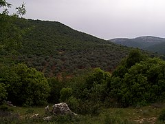
Ajloun mountains
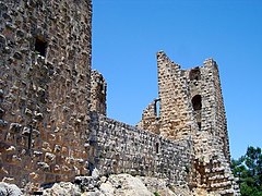
Ajloun Castle
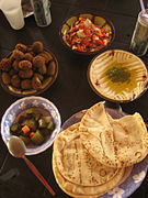
Breakfast at Ajloun
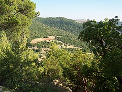
Forests surround Ajloun

Downtown Ajloun

The Great Ajloun Mosque


References[]
This article includes a list of general references, but it remains largely unverified because it lacks sufficient corresponding inline citations. (November 2016) |
- ^ http://dosweb.dos.gov.jo/DataBank/Population_Estimares/PopulationEstimatesbyLocality.pdf
- ^ Hütteroth and Abdulfattah, 1977, p. 162
- ^ Smith, in Robinson and Smith, 1841, vol 3, 2nd appendix, p. 166
- ^ Government of Jordan, Department of Statistics, 1964, p. 13
- ^ Government of Jordan, Department of Statistics, 1964, pp. 115–116
- ^ Teller, Matthew (2012), The Rough Guide to Jordan, Rough Guides, p. 173, ISBN 978-1-85828-740-9
- ^ "Climate: Ajloun". 17 January 2018.
Bibliography[]
- Government of Jordan, Department of Statistics (1964). First Census of Population and Housing. Volume I: Final Tables; General Characteristics of the Population (PDF).
- Hütteroth, Wolf-Dieter; Abdulfattah, Kamal (1977). Historical Geography of Palestine, Transjordan and Southern Syria in the Late 16th Century. Erlanger Geographische Arbeiten, Sonderband 5. Erlangen, Germany: Vorstand der Fränkischen Geographischen Gesellschaft. ISBN 3-920405-41-2.
- Robinson, E.; Smith, E. (1841). Biblical Researches in Palestine, Mount Sinai and Arabia Petraea: A Journal of Travels in the year 1838. 3. Boston: Crocker & Brewster.
Further reading[]
- Dobrzańska-Bzowska, Magdalena; Bzowski, Krzysztof (2008). Praktyczny przewodnik – Bliski Wschód (in Polish). Bielsko-Biała: Wydawnictwo Pascal. pp. 157–158. ISBN 978-83-7513-146-8.
External links[]
| Wikivoyage has a travel guide for Ajlun. |
- http://www.visitjordan.com/visitjordan_cms/MajorAttractions/Ajlun/HistoryCulture/tabid/173/Default.aspx
- Jordan Tourism Board Archived 2014-06-16 at the Wayback Machine
- Middle East Travel Guide
- Ajlun Discussion Forum (in Arabic)
| Rank | Name | Governorate | Pop. | ||||||
|---|---|---|---|---|---|---|---|---|---|
 Amman 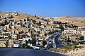 Zarqa |
1 | Amman | Amman Governorate | 1,812,059 |  Irbid  Russeifa | ||||
| 2 | Zarqa | Zarqa Governorate | 635,160 | ||||||
| 3 | Irbid | Irbid Governorate | 502,714 | ||||||
| 4 | Russeifa | Zarqa Governorate | 472,604 | ||||||
| 5 | Al Quwaysimah | Amman Governorate | 296,763 | ||||||
| 6 | Tilā' al-'Alī | Amman Governorate | 251,000 | ||||||
| 7 | Wadi al-Seer | Amman Governorate | 241,830 | ||||||
| 8 | Al Jubayhah | Amman Governorate | 197,160 | ||||||
| 9 | Khuraybat as-Sūq | Amman Governorate | 186,158 | ||||||
| 10 | Sahab | Amman Governorate | 169,434 | ||||||
| show Authority control |
|---|
- ^ "Jordan: Governorates, Major Cities & Urban Localities—Population Statistics, Maps, Charts, Weather and Web Information". City Population. 30 November 2015. Retrieved 19 May 2021.
- Populated places in Ajloun Governorate