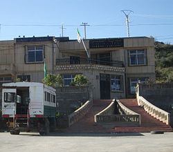
Akfadou
This article needs additional citations for verification. (August 2021) |
Akfadou
ⴰⴽⴼⴰⴷⵓ أكفادو | |
|---|---|
 | |
| Nickname(s): Athmensour | |
 | |
 Akfadou | |
| Coordinates: 36°38′N 4°36′E / 36.633°N 4.600°E | |
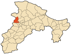
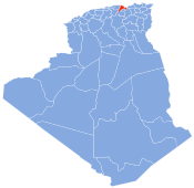
| Country | Algeria |
| Province | Béjaïa |
| Area | |
| • Total | 42.01 km2 (16.22 sq mi) |
| Population (2008) | |
| • Total | 7,358 |
| • Density | 180/km2 (450/sq mi) |
| Time zone | UTC+1 (West Africa Time) |

Akfadou is a town in northern Algeria in the Béjaïa Province. Alternatively the town and its local area are known as Agfadou. This locale is noted for its local population of Barbary macaques, Macaca sylvanus.[1] Notable features in the area include Gouraya National Park.[2]
Etymology[]
The name Akfadou is a contraction of the words "akfuḍ̣̣" and "aḍ̣̣U" which respectively mean "multiple or excess" and "wind".
This name recalls the harsh climate in this region especially in winter when the cold winds gust and heavy snows often isolate small villages. During the exploration of Kabylia by the French occupation in 1850, the word Akfadou was translated as the top wind (French: cime au vent).
References[]
- C. Michael Hogan (2008) Barbary Macaque: Macaca sylvanus, Globaltwitcher.com, ed. Nicklas Stromberg
- UNESCO Biosphere Reserve: Gouraya National Park (2006) Archived 2015-04-04 at the Wayback Machine
Line notes[]
Coordinates: 36°38′N 4°36′E / 36.633°N 4.600°E
This article about a location in Béjaïa Province is a stub. You can help Wikipedia by . |
- Communes of Béjaïa Province
- Berber populated places
- Béjaïa Province geography stubs