Béjaïa
This article needs additional citations for verification. (May 2020) |
Béjaïa
بجاية / Bgayet | |
|---|---|
 | |
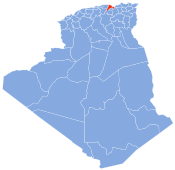
 Location of Béjaïa, Algeria within Béjaïa Province | |
 Béjaïa Location in Algeria | |
| Coordinates: 36°45′04″N 05°03′51″E / 36.75111°N 5.06417°ECoordinates: 36°45′04″N 05°03′51″E / 36.75111°N 5.06417°E | |
| Country | |
| Province | Bejaia Province |
| District | Béjaïa District |
| Area | |
| • Total | 120.22 km2 (46.42 sq mi) |
| Elevation | 949 m (3,114 ft) |
| Population (2008 census) | |
| • Total | 177,988 |
| • Density | 1,500/km2 (3,800/sq mi) |
| Time zone | UTC+1 (CET) |
| Postal code | 06000 |
| Climate | Csa |

Béjaïa (/bɪˈdʒaɪə/; Arabic: بِجَايَة, Bijayah; Kabyle: Bgayet, Vgayet), formerly Bougie and Bugia, is a Mediterranean port city on the in Algeria; it is the capital of Béjaïa Province, Kabylia. Béjaïa is the largest principally Kabyle-speaking city in the Kabylia region of Algeria.
Geography[]

The town is overlooked by the mountain Yemma Gouraya, whose profile is said to resemble a sleeping woman. Other nearby scenic spots include the Aiguades beach and the Pic des Singes (Monkey Peak); the latter site is a habitat for the endangered Barbary macaque, which prehistorically had a much broader distribution than at present. All three of these geographic features are located in the Gouraya National Park. The Soummam river runs past the town.
Under French rule, it was formerly known under various European names, such as Budschaja in German, Bugia in Italian, and Bougie [buˈʒi] in French. The French and Italian versions, due to the town's wax trade, eventually acquired the metonymic meaning of "candle".[1]
History[]
Antiquity and Byzantine era[]
According to Al-Bakri, the bay was first inhabited by Andalusians.[2]
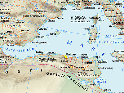
Béjaïa stands on the site of the ancient city of Saldae, a minor port in Carthaginian and Roman times, in an area at first inhabited by Numidian Berbers and founded as a colony for old soldiers by emperor Augustus. It was an important town and a bishopric in the province of Mauretania Caesariensis, and later Sitifensis.

In the fifth century, Saldae became the capital of the short-lived Vandal Kingdom of the Germanic Vandals, which ended in about 533 with the Byzantine conquest, which established an African prefecture and later the Exarchate of Carthage.
Muslim and feudal rulers[]
After the 7th-century Muslim conquest, it was refounded as "Béjaïa"; the Hammadid dynasty made it their capital, and it became an important port and centre of culture.

The son of a Pisan merchant (and probably consul), posthumously known as Fibonacci (c. 1170 – c. 1250), there learned about mathematics (which he called "Modus Indorum") and Hindu-Arabic numerals. He introduced modern mathematics into medieval Europe.[3] A mathematical-historical analysis of Fibonacci's context and proximity to Béjaïa, an important exporter of wax in his time, has suggested that it was actually the bee-keepers of Béjaïa and the knowledge of the bee ancestries that truly inspired the Fibonacci sequence rather than the rabbit reproduction model as presented in his famous book Liber Abaci.[4]
According to Muhammad al-Idrisi, the port was, in the 11th century, a market place between Mediterranean merchant ships and caravans coming from the Sahara desert. Christian merchants settled fundunqs (or Khans) in Bejaïa. The Italian city of Pisa was closely tied to Béjaïa, where it built one of its two permanent consulates in the African continent.[2]
In 1315, Ramon Llull was stoned at Béjaïa,[5][6] where, a few years before, Peter Armengaudius (Peter Armengol) is reputed to have been hanged.[6][7]
After a Spanish occupation (1510–55), the city was taken by the Ottoman Turks in the Capture of Béjaïa in 1555. For nearly three centuries, Béjaïa was a stronghold of the Barbary pirates (see Barbary States). The city consisted of Arabic-speaking Moors, Moriscos and Jews increased by Jewish refugees from Spain. Berber peoples lived not in the city but the surrounding villages and travelled to the city occasionally for markets.
City landmarks include a 16th-century mosque and a fortress built by the Spanish in 1545.
A picture of the Orientalist painter Maurice Boitel, who painted in the city for a while, can be found in the museum of Béjaïa.
French colonial rule[]
It was captured by the French in 1833 and became a part of colonial Algeria. Most of the time it was the seat ('sous-préfecture') of an arrondissement (mid 20th century, 513,000 inhabitants, of whom 20,000 'Bougiates' in the city itself) in the Département of Constantine, until Bougie was promoted to département itself in 1957.
Battle of Béjaïa[]
During World War II, Operation Torch landed forces in North Africa, including a battalion of the British Royal West Kent Regiment at Béjaïa on 11 November 1942.
That same day, at 4:40 PM, a German Luftwaffe air raid struck Béjaïa with thirty Ju 88 bombers and torpedo planes. The transports Awatea and Cathay were sunk and the monitor HMS Roberts was damaged. The following day, the anti-aircraft ship SS Tynwald was torpedoed and sank, while the transport Karanja was bombed and destroyed.[8]
Algerian republic[]
After Algerian independence, it became the eponymous capital of Béjaïa Province, covering part of the eastern Berber region Kabylia.
Ecclesiastical history[]
With the spread of Christianity, Saldae became a bishopric. Its bishop Paschasius was one of the Catholic bishops whom the Arian Vandal king Huneric summoned to Carthage in 484 and then exiled.
Christianity survived the Islamic conquest, the disappearance of the old city of Saldae, and the founding of the new city of Béjaïa. A letter from Pope Gregory VII (1073–1085) exists, addressed to clero et populo Buzee (the clergy and people of Béjaïa), in which he writes of the consecration of a bishop named Servandus for Christian North Africa.[5][6][9]
No longer a residential bishopric, Saldae (v.) is today listed by the Catholic Church as a titular see.[10] and still has incumbents by that title (mostly of the lowest (episcopal) rank, some of the intermediary archiepiscopal rank).
Titular see of Bugia[]
This titular see was for a long time, alternatively and concurrently with the city's authentic Roman Latin name Saldae (v.), called Bugia, the Italian language form (used in the Roman Curia) of Béjaïa.
The 'modern' form and title, Bugia, seems out of use, after having had the following incumbents, all of the lowest (episcopal) rank :
- Miguel Morro (1510 – ?), as Auxiliary Bishop of Mallorca (Balearic Spain) (1510 – ?)
- Fernando de Vera y Zuñiga, Augustinians (O.E.S.A.) (1614.02.17 – 1628.11.13), as Auxiliary Bishop of Badajoz (Spain) (1614.02.17 – 1628.11.13); later Metropolitan Archbishop of Santo Domingo, finally Archbishop-Bishop of Cusco (Peru) (1629.07.16 – death 1638.11.09)
- François Perez (1687.02.05 – death 1728.09.20), as Apostolic Vicar of Cochin (Vietnam) (1687.02.05 – 1728.09.20)
- Antonio Mauricio Ribeiro (1824.09.27 – death ?), as Auxiliary Bishop of Évora (Portugal) (1824.09.27 – ?)
- George Hilary Brown (5 June 1840 until 22 April 1842), as first and only Apostolic Vicar of Lancashire District (England) (1840.06.05 – 1850.09.29), later Titular Bishop of (1842.04.22 – 1850.09.29), promoted first bishop of successor see Liverpool (1850.09.29 – 1856.01.25)
Climate[]
Béjaïa, like most cities along the coast of Algeria, has a Mediterranean climate (Köppen climate classification Csa), with very warm, dry summers and mild, wet winters.
| hideClimate data for Béjaïa | |||||||||||||
|---|---|---|---|---|---|---|---|---|---|---|---|---|---|
| Month | Jan | Feb | Mar | Apr | May | Jun | Jul | Aug | Sep | Oct | Nov | Dec | Year |
| Record high °C (°F) | 27.7 (81.9) |
32.0 (89.6) |
37.0 (98.6) |
33.0 (91.4) |
37.3 (99.1) |
42.8 (109.0) |
44.7 (112.5) |
48.4 (119.1) |
42.5 (108.5) |
40.0 (104.0) |
37.4 (99.3) |
33.0 (91.4) |
48.4 (119.1) |
| Average high °C (°F) | 16.4 (61.5) |
16.8 (62.2) |
17.7 (63.9) |
19.3 (66.7) |
22.0 (71.6) |
25.3 (77.5) |
28.7 (83.7) |
29.3 (84.7) |
27.8 (82.0) |
24.3 (75.7) |
20.3 (68.5) |
16.9 (62.4) |
22.1 (71.7) |
| Daily mean °C (°F) | 12.1 (53.8) |
12.3 (54.1) |
13.1 (55.6) |
14.7 (58.5) |
17.6 (63.7) |
21.0 (69.8) |
24.0 (75.2) |
24.8 (76.6) |
23.2 (73.8) |
19.7 (67.5) |
15.8 (60.4) |
12.7 (54.9) |
17.6 (63.7) |
| Average low °C (°F) | 7.7 (45.9) |
7.6 (45.7) |
8.5 (47.3) |
10.1 (50.2) |
13.1 (55.6) |
16.6 (61.9) |
19.3 (66.7) |
20.2 (68.4) |
18.5 (65.3) |
15.0 (59.0) |
11.2 (52.2) |
8.4 (47.1) |
13.0 (55.4) |
| Record low °C (°F) | −1.0 (30.2) |
−4.0 (24.8) |
−0.1 (31.8) |
2.0 (35.6) |
5.8 (42.4) |
7.8 (46.0) |
13.0 (55.4) |
11.0 (51.8) |
11.0 (51.8) |
8.0 (46.4) |
1.6 (34.9) |
−2.4 (27.7) |
−4.0 (24.8) |
| Average precipitation mm (inches) | 99.7 (3.93) |
85.9 (3.38) |
100.4 (3.95) |
70.7 (2.78) |
41.2 (1.62) |
16.2 (0.64) |
5.8 (0.23) |
13.0 (0.51) |
40.4 (1.59) |
89.5 (3.52) |
99.7 (3.93) |
135.0 (5.31) |
797.5 (31.39) |
| Average relative humidity (%) | 78.5 | 77.6 | 77.9 | 77.9 | 79.9 | 76.9 | 75.0 | 74.6 | 76.4 | 76.3 | 75.3 | 76.0 | 76.9 |
| Source 1: NOAA (1968-1990)[11] | |||||||||||||
| Source 2: climatebase.ru (extremes, humidity)[12][13] | |||||||||||||
Demography[]
 Cap Carbon Lighthouse in 2013 | |
 | |
| Location | Cap Carbonbr Béjaïa |
|---|---|
| Coordinates | 36°46′34.25″N 5°6′14.83″E / 36.7761806°N 5.1041194°E |
| Constructed | 1906[14] |
| Construction | masonry tower |
| Tower height | 14.60 metres (47.9 ft)[14] |
| Tower shape | cylindrical tower with balcony and lantern rising from the keeper’s house |
| Markings | white tower, black lantern roof |
| Operator | Office Nationale de Signalisation Maritime |
| Focal height | 224.10 metres (735.2 ft)[14] |
| Range | 29 nautical miles (54 km; 33 mi)[14] |
| Characteristic | Fl (3) W 20s.[15] |
| Admiralty no. | E6572 |
| NGA no. | 22328 |
| ARLHS no. | ALG-007[16] |
The population of the city in 2008 in the latest census was 177,988.
| Year | Population |
|---|---|
| 1901 | 14,600 |
| 1906 | 17,500 |
| 1911 | 10,000 |
| 1921 | 19,400 |
| 1926 | 15,900 |
| 1931 | 25,300 |
| 1936 | 30,700 |
| 1948 | 28,500 |
| 1954 | 43,900 |
| 1960 | 63,000 |
| 1966 | 49,900 |
| 1974 | 104,000 |
| 1977 | 74,000 |
| 1987 | 114,500 |
| 1998 | 144,400 |
| 2008 | 177,988 |
Economy[]

The northern terminus of the Hassi Messaoud oil pipeline from the Sahara, Béjaïa is the principal oil port of the Western Mediterranean. Exports, aside from crude petroleum, include iron, phosphates, wines, dried figs, and plums. The city also has textile and cork industries.[citation needed]
The Béni Mansour-Bejaïa line railroad terminates in Béjaïa. The airport of the city is Abane Ramdane Airport.
Cevital has its head office in the city.[18]
The city's soccer team is JSM Béjaïa and currently plays in the Algerian Ligue Professionnelle 2.
Twin towns – sister cities[]
Béjaïa has an official friendly relationship with:
 Glasgow, Scotland, since 1995
 Brest
Brest Bad Homburg
See also[]
- European enclaves in North Africa before 1830
- List of lighthouses in Algeria
- Saldae, for Roman history and concurrent Catholic titular see
- Related people
References[]
- ^ "Bougie (n)". Oxford English Dictionary. Oxford University Press. Retrieved 29 November 2012.
Etymology: < French bougie wax candle, < Bougie (Arabic Bijiyah), a town in Algeria which carried on a trade in wax
Available online to subscribers - ^ Jump up to: a b Bejaia - Algeria, Muslimheritage.com
- ^ Stephen Ramsay, Reading Machines: Toward an Algorithmic Criticism, (University of Illinois Press, 2011), 64.
- ^ Scott, T.C.; Marketos, P. (March 2014), On the Origin of the Fibonacci Sequence (PDF), MacTutor History of Mathematics archive, University of St Andrews
- ^ Jump up to: a b Stefano Antonio Morcelli, Africa christiana, Volume I, Brescia 1816, p. 269
- ^ Jump up to: a b c H. Jaubert, Anciens évêchés et ruines chrétiennes de la Numidie et de la Sitifienne, in Recueil des Notices et Mémoires de la Société archéologique de Constantine, vol. 46, 1913, pp. 127-129
- ^ "J. Frank Henderson, "Moslems and the Roman Catholic Liturgical Calendar. Documentation" (2003), p. 18" (PDF). Archived from the original (PDF) on 4 March 2016. Retrieved 26 February 2015.
- ^ Atkinson 2002.
- ^ J. Mesnage, L'Afrique chrétienne, Paris 1912, pp. 8 e 268-269
- ^ Annuario Pontificio 2013 (Libreria Editrice Vaticana 2013 ISBN 978-88-209-9070-1), p. 963
- ^ "Climate Normals for Béjaïa". Retrieved 11 February 2013.
- ^ "Béjaïa, Algeria". Climatebase.ru. Retrieved 11 February 2013.
- ^ @extremetemps (10 August 2021). "Update on the Mediterranean heat..." (Tweet) – via Twitter.
- ^ Jump up to: a b c d "Cap Carbon". Office Nationale de Signalisation Maritime. Ministere des Travaux Publics. Retrieved 28 April 2017.
- ^ List of Lights, Pub. 113: The West Coasts of Europe and Africa, the Mediterranean Sea, Black Sea and Azovskoye More (Sea of Azov) (PDF). List of Lights. United States National Geospatial-Intelligence Agency. 2015.
- ^ Rowlett, Russ. "Lighthouses of Eastern Algeria". The Lighthouse Directory. University of North Carolina at Chapel Hill. Retrieved 27 April 2017.
- ^ populstat.info Archived 3 March 2016 at the Wayback Machine
- ^ "Cevital & vous Archived 12 September 2011 at the Wayback Machine." Cevital. Retrieved on 26 August 2011. "Adresse : Nouveau Qaui Port de -Béjaïa - Algérie"
- Atkinson, Rick (2013). An Army At Dawn: The War in North Africa, 1942-1943. Little, Brown Book Group. ISBN 978-1-4055-2727-9.
External links[]
| Wikimedia Commons has media related to Béjaïa. |
- (in French) Bgayet.Net
- (in French) History of Béjaïa
- GigaCatholic, with titular incumbent biography links
- Google map of Béjaïa
| show Articles Related to Béjaïa |
|---|
- Communes of Béjaïa Province
- Former Spanish colonies
- Kabylie
- Cities in Algeria
- Province seats of Algeria
- Lighthouses in Algeria