Tizi Ouzou
hideThis article has multiple issues. Please help or discuss these issues on the talk page. (Learn how and when to remove these template messages)
|
Tizi Ouzou
Tizi Wezzu تيزي وزو | |
|---|---|
 | |
 | |
 Tizi Ouzou | |
| Coordinates: 36°43′N 4°3′E / 36.717°N 4.050°E | |
| Country | |
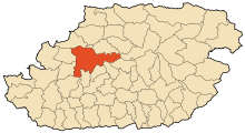
| Province | Tizi Ouzou Province |
| District | Tizi Ouzou District |
| Area | |
| • Total | 102.36 km2 (39.52 sq mi) |
| Population (2008 census) | |
| • Total | 142,991 |
| • Density | 1,400/km2 (3,600/sq mi) |
| Time zone | UTC+1 (CET) |
| Postal code | 15000 |
| Climate | Csa |
| Website | www |

Tizi Ouzou or Thizi Wezzu (Berber language: Tizi Wezzu) is a city in north central Algeria. It is among the largest cities in Algeria. It is the second most populous city in the Kabylie region after Bgayet.
History[]
Etymology[]
The name Tizi Ouzou is made up of two Kabyle words: Tizi meaning col, and Ouzou (from Azzu) meaning Genisteae. The full name of the locality therefore means "the col of the Genisteae".[1]
Friction[]
Islamists looted, and burned to the ground, a Pentecostal church on 9 January 2010. The pastor was quoted as saying that worshipers fled when local police left a gang of local rioters unchecked.[2]
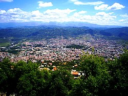
Geography[]
This city is located in the heart of Kabylie. It is 102.36 square kilometres (39.52 sq mi) in area. Tizi Ouzou is located in the valley of Assif N Sébaou. It is surrounded by mountains. The city is at an altitude of 200 metres (660 ft). It is bounded on the north by Mount Belloua which rises to 850 metres (2,790 ft) above sea level. A portion of the old city of Tizi Ouzou (known as the High City) backed the east slopes of the mountain. At the top of the mountain Belloua lies the village of Redjaouna. The latter is attached to the town of Tizi Ouzou.[citation needed]
Climate[]
Tizi Ouzou experiences a hot Mediterranean climate (Köppen climate classification Csa).
| hideClimate data for Tizi Ouzou (2001–2015 averages) | |||||||||||||
|---|---|---|---|---|---|---|---|---|---|---|---|---|---|
| Month | Jan | Feb | Mar | Apr | May | Jun | Jul | Aug | Sep | Oct | Nov | Dec | Year |
| Record high °C (°F) | 24.0 (75.2) |
30.0 (86.0) |
31.9 (89.4) |
37.8 (100.0) |
41.0 (105.8) |
43.0 (109.4) |
45.7 (114.3) |
45.2 (113.4) |
43.0 (109.4) |
40.5 (104.9) |
31.7 (89.1) |
27.0 (80.6) |
45.7 (114.3) |
| Average high °C (°F) | 15.4 (59.7) |
15.9 (60.6) |
19.2 (66.6) |
22.2 (72.0) |
26.1 (79.0) |
32.0 (89.6) |
35.8 (96.4) |
35.9 (96.6) |
31.4 (88.5) |
27.9 (82.2) |
20.3 (68.5) |
16.4 (61.5) |
24.8 (76.6) |
| Daily mean °C (°F) | 11.4 (52.5) |
11.4 (52.5) |
14.1 (57.4) |
16.7 (62.1) |
20.2 (68.4) |
25.1 (77.2) |
28.7 (83.7) |
28.9 (84.0) |
25.2 (77.4) |
22.1 (71.8) |
15.8 (60.4) |
12.2 (54.0) |
19.2 (66.6) |
| Average low °C (°F) | 7.2 (45.0) |
7.5 (45.5) |
9.0 (48.2) |
11.2 (52.2) |
14.2 (57.6) |
18.2 (64.8) |
21.6 (70.9) |
21.9 (71.4) |
19.0 (66.2) |
16.2 (61.2) |
11.4 (52.5) |
8.1 (46.6) |
13.9 (57.0) |
| Record low °C (°F) | −3.0 (26.6) |
0.0 (32.0) |
0.6 (33.1) |
4.0 (39.2) |
6.6 (43.9) |
8.2 (46.8) |
16.0 (60.8) |
16.0 (60.8) |
12.4 (54.3) |
7.5 (45.5) |
3.5 (38.3) |
0.7 (33.3) |
−3.0 (26.6) |
| Average precipitation mm (inches) | 98.2 (3.87) |
95.3 (3.75) |
90.0 (3.54) |
80.8 (3.18) |
52.8 (2.08) |
18.4 (0.72) |
4.6 (0.18) |
7.8 (0.31) |
36.8 (1.45) |
55.3 (2.18) |
106.4 (4.19) |
116.3 (4.58) |
705.0 (27.76) |
| Source: Infoclimat [3] 2001-2015 normals, records 2001-2015. | |||||||||||||
Demographics[]
There were 118,542 people in 1998.
Sport[]
The local professional football team is JS Kabylie.
Education[]
Mouloud Mammeri University of Tizi-Ouzou is the local university. There are three campuses: Campus Hasnaoua I, Campus Hasnaoua II, and Campus Tamda. [4]
Année après année, la wilaya obtient les meilleurs taux de réussite à l’examen du baccalauréat au niveau national
Notable people[]
- Mohamed Belhocine, Algerian medical scientist, professor of internal medicine and epidemiology.
References[]
- ^ Foudil Cheriguen, Toponymie algérienne des lieux habités (les noms composés), Alger, Épigraphe, 1993, p. 155-156
- ^ "Protestant Church Burned in Algeria". New York Times. New York, New York: nytimes.com. The Associated Press. 11 January 2010.
- ^ "Normales et records climatologiques 2001-2015 à Tizi-Ouzou - Infoclimat". www.infoclimat.fr.
- ^ "Accueil > Université > Album photos Archived 2015-09-28 at the Wayback Machine." Mouloud Mammeri University of Tizi-Ouzou. Retrieved on 28 September 2015.
External sources[]
- Jonathan Oaks: Algeria. Bradt Travel Guides 2008, ISBN 978-1-84162-232-3, p. 110 (restricted online version (Google Books))
- "Geographical information on Tizi Ouzou, Algeria". Falling Rain Genomics, Inc. Retrieved 27 April 2008.
| Wikimedia Commons has media related to Tizi Ouzou. |
Coordinates: 36°43′N 4°03′E / 36.717°N 4.050°E

| show Authority control |
|---|
- Communes of Tizi Ouzou Province
- Kabylie
- Province seats of Algeria