Aldgate East tube station
| Aldgate East | |
|---|---|
 | |
 Aldgate East Location of Aldgate East in Central London | |
| Location | Whitechapel |
| Local authority | London Borough of Tower Hamlets |
| Managed by | London Underground |
| Owner | Transport for London |
| Number of platforms | 2 |
| Fare zone | 1 |
| OSI | Aldgate |
| London Underground annual entry and exit | |
| 2015 | |
| 2016 | |
| 2017 | |
| 2018 | |
| 2019 | |
| Key dates | |
| 6 October 1884 | Opened |
| 31 October 1938 | resited |
| Other information | |
| External links | |
| WGS84 | 51°30′55″N 0°04′20″W / 51.5152°N 0.0722°WCoordinates: 51°30′55″N 0°04′20″W / 51.5152°N 0.0722°W |

Aldgate East is a London Underground station on Whitechapel High Street in Whitechapel, in London, England. It takes its name from the City of London ward of Aldgate, the station lying to the east of the ward (and the City). It is on the Hammersmith & City line between Liverpool Street and Whitechapel, and on the District line between Tower Hill and Whitechapel, in Travelcard Zone 1.[5]
History[]
This section needs additional citations for verification. (January 2015) |
Original station[]
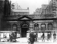
The name "Commercial Road" had been proposed for the original Aldgate East station, which opened on 6 October 1884 as part of an eastern extension to the District Railway (now the District line),[6] some 500 feet (150 m) to the west of the current station, close to the Metropolitan Railway's Aldgate station. However, when the link to the Metropolitan Railway at Liverpool Street was built, the curve had to be particularly sharp owing to the location of Aldgate East station, at which the track needed to be straight.
Resited station[]

As part of the London Passenger Transport Board's 1935–1940 New Works Programme the triangular junction at Aldgate was enlarged, to allow for a much gentler curve and to ensure trains that were held on any leg of the triangle did not foul any signals or points elsewhere.[7] The new Aldgate East platforms were sited almost immediately to the east of their predecessors, with one exit facing west toward the original location, and another at the eastern end of the new platforms.
The new eastern exit was now close enough to the next station along the line, St Mary's (Whitechapel Road), that this station could also be closed,[note 1] reducing operational overheads and journey times, because the new Aldgate East had effectively replaced two earlier stations.
The new station, which opened on 31 October 1938,[6] (the earlier station closing permanently the previous night[8][9]) was designed to be completely subterranean, providing a much-needed pedestrian underpass for the road above.

However, in order to accommodate the space needed for this, and the platforms below, the existing track required lowering by more than seven feet (2 m). To achieve this task whilst still keeping the track open during the day, the bed underneath the track was excavated, and the track held up by a timber trestle framework. Then, once excavation was complete and the new station constructed around the site, an army of over 900 workmen lowered the whole track simultaneously in one night, using overhead hooks to suspend the track when necessary.[10] The hooks still remain.

Past proposals[]
A campaign was launched by a local councillor in a bid to change the name of the station to Brick Lane tube station by 2012,[11] but this had no official support and was not successful. The same councillor has also campaigned to have Shoreditch High Street railway station renamed "Banglatown".[12]
The station today[]
This section needs additional citations for verification. (January 2015) |
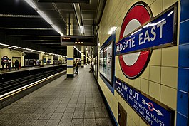
The station has no surface buildings.[13] Ticket barriers control access to all platforms.
District and Hammersmith & City line trains running into Aldgate East along two sides of the triangle (from Liverpool Street and from Tower Hill) pass through the site of the earlier station, most of which has been obliterated by the current junction alignment, although the extensive width and height and irregular shape of the tunnel can be observed.
Since the station was built completely under a widened road, and was built after concrete had started to be used as a construction material, the platforms have a particularly high headroom. This—combined with the late-1930s style of tiling, typical of the stations of the then London Passenger Transport Board—gives the platform area of the station a particularly airy and welcoming appearance, unusual on the Underground at the time of construction. The tiling contains relief tiles, showing devices pertinent to London Transport and the area it served; these were designed by Harold Stabler and made by the Poole Pottery.
Station improvements[]
The station was Metronet's first refurbished (and show-piece) station, refurbished in 'heritage' style.[14] Work actually began at platform level earlier in 2007.[14] On 9 March 2007 it was noted that every other platform bullseye and its associated blue enamel "Way Out" plate below had been removed on both platforms, marking the end of the only sub-surface 'New Works' station.[14] By 14 March all the roundels had been removed and temporary signs substituted.[14] The north-east entrance was also closed from 10 March 2007 until 2009.[14] As of 23 May 2007, the tiling was removed on the eastbound platform and the walls were rough cemented but the tiles remained on the westbound one, although it only took a few days.[14] The new framework for lighting and cabling had been installed.[14]
Services and connections[]
District line[]
This is the general off-peak frequency. During peak times trains also operate to Wimbledon. During off-peak times, 3 trains per hour from Wimbledon terminate at Barking (as of December 2014).
- 12 tph eastbound to Upminster (On Sundays alternate trains run to Barking only)
- 3 tph eastbound to Barking
- 6 tph westbound to Ealing Broadway
- 6 tph westbound to Richmond
- 3 tph westbound to Wimbledon
Hammersmith & City line[]
The typical off-peak service in trains per hour (tph) is:
- 6 tph eastbound to Barking[15][16]
- 6 tph westbound to Hammersmith[15][17]
There is no regular service, however there are two Circle line trains per day that run from Barking to Edgware Road via Victoria before 6 a.m. (as of February 2015).[18]
Buses[]
London Buses routes 15, 25, 115, 135, 205, 242, 254 and night routes N15, N25, N205, N253 and N550 serve the station.[19][20]
Nearby tourist attractions[]
- Whitechapel Art Gallery
- Petticoat Lane Market
- Brick Lane
- Spitalfields Market
- Hamish Mackie's public artwork of six galloping horses
Notes and references[]
Notes[]
References[]
- ^ "Out-of-Station Interchanges" (Microsoft Excel). Transport for London. 2 January 2016. Retrieved 28 August 2016.
- ^ Jump up to: a b c "Multi-year station entry-and-exit figures (2007–2017)" (XLSX). London Underground station passenger usage data. Transport for London. January 2018. Retrieved 22 July 2018.
- ^ "Station Usage Data" (CSV). Usage Statistics for London Stations, 2018. Transport for London. 21 August 2019. Retrieved 27 April 2020.
- ^ "Station Usage Data" (XLSX). Usage Statistics for London Stations, 2019. Transport for London. 23 September 2020. Retrieved 9 November 2020.
- ^ Standard Tube Map (PDF) (Map). Not to scale. Transport for London. June 2021. Archived (PDF) from the original on 1 August 2021. Retrieved 4 August 2021.
- ^ Jump up to: a b c Clive's Underground Line Guides - District line
- ^ H.F. Howson, London's Underground, 4th ed. London: Ian Allan, 1967, OCLC 502266970, p. 47.
- ^ H.V. Borley, Chronology of London Railways, Oakham, Leicester: Railway & Canal Historical Society, 1982, ISBN 9780901461339.
- ^ J.E. Connor and B. Halford, Forgotten Stations of Greater London, Colchester: Connor & Butler, 1991, ISBN 9780947699178.
- ^ Howson, pp. 47–48.
- ^
"Bid to name Tube stop Brick Lane". BBC News. bbc.co.uk. 15 December 2006. Archived from the original on 16 January 2007. Retrieved 10 January 2007.
Tower Hamlets councillor Abdul Ullah wants the Tube station to be renamed in time for the 2012 summer Olympics. He told BBC London: 'I think it will truly reflect the character of the area by renaming Aldgate East... people get it confused with Aldgate.' He said the area's tourist trade was being affected because, while people had heard of Brick Lane and its reputation for curry restaurants, they could not find it on a Tube map.
- ^ "Calls to rename East End station". BBC News. bbc.co.uk. 20 May 2008. Retrieved 10 June 2008.
Tower Hamlets councillor Abdal Ullah said the new station should be called "Banglatown" to reflect the strong Bangladeshi community. But a TfL spokesman said 'It is important that a station name takes into account the street or the official name of its area, as recorded on official maps.'
- ^ "Tube Facts - Tube Stations that have no surface buildings". Archived from the original on 22 February 2017. Retrieved 28 March 2015.
- ^ Jump up to: a b c d e f g "Station Refurbishment Summary" (PDF). London Underground Railway Society. July 2007. Retrieved 28 March 2015.
- ^ Jump up to: a b Clive's Underground Line Guides - Hammersmith & City line
- ^ "Hammersmith & City line timetable: From Aldgate East Underground Station to Whitechapel Underground Station". Transport for London. Retrieved 28 March 2015.
- ^ "Hammersmith & City line timetable: From Aldgate East Underground Station to Liverpool Street Underground Station". Transport for London. Retrieved 28 March 2015.
- ^ "London Underground: Why are Circle line trains showing up at Whitechapel? | CityMetric".
- ^ "Buses from Aldgate East" (PDF). TfL. 15 June 2019. Retrieved 3 June 2021.
- ^ "Night buses from Aldgate East" (PDF). TfL. 17 October 2020. Retrieved 3 June 2021.
Bibliography[]
- Butt, R. V. J. (1995). The Directory of Railway Stations: details every public and private passenger station, halt, platform and stopping place, past and present (1st ed.). Sparkford: Patrick Stephens Ltd. ISBN 978-1-85260-508-7. OCLC 60251199.
- Jowett, Alan (2000). Jowett's Nationalised Railway Atlas (1st ed.). Penryn, Cornwall: Atlantic Transport Publishers. ISBN 978-0-906899-99-1. OCLC 228266687.
External links[]
| Wikimedia Commons has media related to Aldgate East tube station. |
| show District line |
|---|
| show Metropolitan line |
|---|
- Rail transport stations in London fare zone 1
- District line stations
- Hammersmith & City line stations
- Tube stations in the London Borough of Tower Hamlets
- Former Metropolitan and Metropolitan District Joint Railway stations
- Railway stations in Great Britain opened in 1884
- Railway stations in Great Britain closed in 1938
- Railway stations in Great Britain opened in 1938
- Whitechapel
- Railway stations located underground in the United Kingdom