Alma, Quebec
Alma | |
|---|---|
Town | |
 | |
 Coat of arms | |
| Motto(s): La ville de l'hospitalité | |
 | |
 Alma Location in Saguenay–Lac-Saint-Jean Quebec | |
| Coordinates: 48°33′N 71°39′W / 48.550°N 71.650°WCoordinates: 48°33′N 71°39′W / 48.550°N 71.650°W[1] | |
| Country | Canada |
| Province | Quebec |
| Region | Saguenay–Lac-Saint-Jean |
| RCM | Lac-Saint-Jean-Est |
| Amalgamation | 1962 (of Isle-Maligne, Naudville, Riverbend and St-Joseph d'Alma.) |
| Constituted | February 21, 2001 (amalgamation with Delisle) |
| Government | |
| • Mayor | Marc Asselin |
| • Federal riding | Lac-Saint-Jean |
| • Prov. riding | Lac-Saint-Jean |
| Area | |
| • Town | 230.30 km2 (88.92 sq mi) |
| • Land | 195.59 km2 (75.52 sq mi) |
| • Urban | 41.10 km2 (15.87 sq mi) |
| • Metro | 340.35 km2 (131.41 sq mi) |
| Population (2011)[3] | |
| • Town | 30,904 |
| • Density | 158.0/km2 (409/sq mi) |
| • Urban | 26,016 |
| • Urban density | 633.0/km2 (1,639/sq mi) |
| • Metro | 33,018 |
| • Metro density | 97.0/km2 (251/sq mi) |
| • Pop 2006-2011 | |
| • Dwellings | 13,884 |
| Time zone | UTC−5 (EST) |
| • Summer (DST) | UTC−4 (EDT) |
| Postal code(s) | G8B, G8C & G8E |
| Area code(s) | 418 and 581 |
| Highways | |
| Telephone Exchanges | 212, 321, 480-2, 487, 662, 668-9, 719, 720, 769 |
| NTS Map | 22D12 Alma |
| GNBC Code | EFHQD |
| Website | www |

Alma (2011 Town population: 30,904; CA Population 33,018; UA Population 26,016) is a town in the Canadian province of Quebec.
Geography[]
Alma is located on the southeast coast of Lac Saint-Jean where it flows into the Saguenay River, in the Saguenay–Lac-Saint-Jean region of Quebec, Canada, approximately 175 km north of Quebec City. Alma is the seat of Lac-Saint-Jean-Est Regional County Municipality. Alma is the second city in population in the Saguenay-Lac-Saint-Jean region after the city of Saguenay.
Alma is the seat of the judicial district of Alma.[6]
History[]
The present town of Alma was formed in 1962 from the merging of four villages: Isle-Maligne, Naudville, Riverbend and St-Joseph d'Alma. The oldest of the villages, , was founded in 1867 by Damase Boulanger. The area became an important industrial centre during the 1920s and 1930s with the construction of a hydro-electrical power station on the Grande-Décharge River, a paper mill (Price) and an aluminum smelting plant (Alcan), all of which are still in activity today.
In 2002, Alma merged with the Municipality of Delisle. Both modern day Alma and St-Joseph d'Alma are named after the Battle of the Alma.
Demographics[]
Population trend:[7]
- Population in 2011: 30,904 (2006 to 2011 population change: 3%)
- Population in 2006: 29,998
- Population total in 2001: 30,126
- Alma (ville): 25,918
- Delisle (municipality): 4,208
- Population in 1996:
- Alma (ville): 26,127
- Delisle (municipality): 4,256
- Population in 1991:
- Alma (ville): 25,910
- Delisle (municipality): 4,281
Private dwellings occupied by usual residents: 13324 (total dwellings: 13884)
Mother tongue:[8]
- English as first language: 0.5%
- French as first language: 98.5%
- English and French as first language: 0.1%
- Other as first language: 0.9%
| Visible minority and Aboriginal population (Canada 2006 Census) | |||
|---|---|---|---|
| Population group | Population | % of total population | |
| White | 29,025 | 97.7% | |
| Visible minority group Source:[9] |
South Asian | 0 | 0% |
| Chinese | 45 | 0.2% | |
| Black | 40 | 0.1% | |
| Filipino | 0 | 0% | |
| Latin American | 20 | 0.1% | |
| Arab | 15 | 0.1% | |
| Southeast Asian | 60 | 0.2% | |
| West Asian | 0 | 0% | |
| Korean | 0 | 0% | |
| Japanese | 10 | 0% | |
| Visible minority, n.i.e. | 0 | 0% | |
| Multiple visible minority | 0 | 0% | |
| Total visible minority population | 200 | 0.7% | |
| Aboriginal group Source:[10] |
First Nations | 125 | 0.4% |
| Métis | 335 | 1.1% | |
| Inuit | 0 | 0% | |
| Aboriginal, n.i.e. | 10 | 0% | |
| Multiple Aboriginal identity | 0 | 0% | |
| Total Aboriginal population | 480 | 1.6% | |
| Total population | 29,705 | 100% | |
Transportation[]
Alma is serviced by the Alma Airport, located 4.1 km to the south of the town.
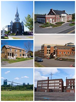
Image gallery[]
Petite-Décharge

Downtown Alma

Former Isle-Maligne town hall

Rio Tinto Alcan aluminum smelter in Alma


Notable people[]
- Émilie Fortin Tremblay (1872-1949), one of the first white women to cross the Chilkoot on the way to the Yukon gold fields
- Mario Tremblay, hockey player and former coach of the Montreal Canadiens
- Marie-Lise Pilote, comedian
- Michel Côté, comedian
- Guy Cloutier, producer and artist manager
- Lucien Bouchard, former premier of Québec
- Guillaume Desbiens, hockey player
- Charles Hudon, hockey player for the Montreal Canadiens
- Pierre Lapointe, singer
- André Bouchard, businessman and builder
- Chris Boucher, basketball player for the Toronto Raptors
- Camille Bedard, hockey player
See also[]
- List of cities in Quebec
References[]
- ^ Reference number 1013 of the Commission de toponymie du Québec (in French)
- ^ Jump up to: a b Ministère des Affaires municipales, des Régions et de l'Occupation du territoire - Répertoire des municipalités: Alma Archived 2012-01-15 at the Wayback Machine
- ^ Jump up to: a b "Alma census profile". 2011 Census data. Statistics Canada. Retrieved 2012-05-24.
- ^ Jump up to: a b "Alma (Population centre) community profile". 2011 Census data. Statistics Canada. Retrieved 2012-05-24.
- ^ Jump up to: a b "Alma (Census agglomeration) community profile". 2011 Census data. Statistics Canada. Retrieved 2012-05-24. The census agglomeration consists of Alma and Saint-Nazaire. In the 2006 census, the census agglomeration had also included Saint-Henri-de-Taillon.
- ^ Territorial Division Act. Revised Statutes of Quebec D-11.
- ^ Statistics Canada: 1996, 2001, 2006, 2011 census
- ^ "Alma community profile". 2006 Census data. Statistics Canada. Retrieved 2010-11-10.
- ^ [1], Community Profiles from the 2006 Census, Statistics Canada - Census Subdivision
- ^ [2], Aboriginal Population Profile from the 2006 Census, Statistics Canada - Census Subdivision
External links[]
| Wikimedia Commons has media related to Alma, Quebec. |
- (in French) Ville d'Alma
| show Adjacent Municipal Subdivisions |
|---|
| hide | |
|---|---|
| Cities | |
| Municipalities |
|
| Parishes | |
| Villages | |
| Unorganized territories | |
| |
| show Authority control |
|---|
- Alma, Quebec
- Cities and towns in Quebec