Alpes Cottiae
| Provincia Alpes Cottiae | |||||||
|---|---|---|---|---|---|---|---|
| Province of the Roman Empire | |||||||
| 63 AD–476 AD | |||||||
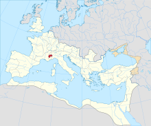 The Roman Empire ca. AD 125, with the province of Alpes Cottiae highlighted. | |||||||
| Capital | Segusio | ||||||
| History | |||||||
| Historical era | Antiquity | ||||||
• Created by Nero | 63 AD | ||||||
• Deposition of Romulus Augustulus | 476 AD | ||||||
| |||||||
| Today part of | |||||||
The Alpes Cottiae (Latin pronunciation: [ˈaɫpeːs ˈkɔttɪ.ae̯]; English: 'Cottian Alps') were a small province of the Roman Empire founded in 63 AD by Nero. It was one of the three provinces straddling the Alps between modern France and Italy, along with the Alpes Graiae et Poeninae and Alpes Maritimae.
The capital of the province was Segusio (modern Susa, Piedmont). Other important settlements were located at Eburodunum and (Briançon).[1] Named after the 1st-century BC ruler of the region, Marcus Julius Cottius, the toponym survives today in the Cottian Alps.[2]
History[]
The province had its origin in a local chiefdom controlled by the enfranchised king Marcus Julius Donnus, who ruled over Ligurian tribes of the region by the middle of the 1st century BC. He was succeeded by his son, Marcus Julius Cottius, who offered no opposition to the integration of his realm into the Roman imperial system under Augustus in 15–14 BC, then kept on ruling on native tribes as a praefectus civitatium of a Regnum Cotti.[3][1][2]
After the death of his son in 63 AD, the region was annexed by Nero and made into a procuratorial province known as provincia Alpium Cottiarum.[4][1][2]
During the reign of Diocletian (284–305), the western part of the province was transferred to the Alpes Maritimae, and the eastern part allocated under a praeses to the Diocese of Italy.[1]
Settlements[]
Settlements in Alpes Cottiae included:
- Ad Fines (Malano) ("mansio", customs post)
- Ocelum (Celle) ("oppidum", Celtic village)
- Ad Duodecimum (Saint-Didier) ("mutatio")
- Segusio (Susa) (capital)
- Venausio (Venaus) (oppidum)
- Scingomagus / Excingomagus (Exilles) (oppidum, possibly Donnus's capital)
- Caesao / Goesao (Cesana Torinese) ("castrum")
- Ad Martes Ultor (late imperial "Ulcense") (Oulx) ("castrum")
- Brigantium (Briançon) (mansio)
- Mons Matronae (Mont Genèvre)
See also[]
References[]
- ^ a b c d Graßl 2006.
- ^ a b c Syme & Levick 2012.
- ^ Barruol 1969, p. 41.
- ^ Barruol 1969, p. 176.
Bibliography[]
- Barruol, Guy (1969). Les Peuples préromains du Sud-Est de la Gaule: étude de géographie historique. E. de Boccard. OCLC 3279201.
- Graßl, Herbert (2006). "Alpes Cottiae". Brill's New Pauly. doi:10.1163/1574-9347_bnp_e116370.
- Syme, Ronald; Levick, Barbara M. (2012). "Iulius Cottius, Marcus". The Oxford Classical Dictionary. Oxford University Press. doi:10.1093/acrefore/9780199381135.013.3412. ISBN 978-0-19-954556-8.
Further reading[]
- Tilmann Bechert: Die Provinzen des römischen Reiches: Einführung und Überblick. von Zabern, Mainz 1999.
- Bartolomasi : Valsusa Antica . Alzani, 1975.
- Prieur, Jean (1968). La province romaine des Alpes Cottiennes. Impr. R. Gauthier. OCLC 834310867.
Provinces of the early Roman Empire (117 AD) | ||
|---|---|---|
| 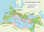 | |
† Italy was never constituted as a province, instead retaining a special juridical status until Diocletian's reforms. | ||
Coordinates: 45°01′00″N 6°47′03″E / 45.0167°N 6.7841°E

This Ancient Rome–related article is a stub. You can help Wikipedia by . |
This article related to geography of France is a stub. You can help Wikipedia by . |
- Provinces of the Roman Empire
- Tres Alpes
- 60s establishments in the Roman Empire
- 476 disestablishments
- 470s disestablishments in the Roman Empire
- Ancient Rome stubs
- France geography stubs