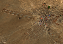
Altai City
Altai
Алтай ᠠᠯᠲᠠᠢ | |
|---|---|
| Yesönbulag District Есөнбулаг сум ᠶ᠋ᠢᠰᠦᠨᠪᠤᠯᠠᠭᠰᠤᠮᠤ | |
 | |
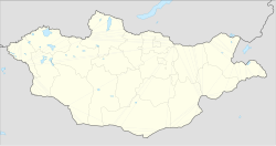 Altai Location in Mongolia | |
| Coordinates: 46°22′22″N 96°15′26″E / 46.37278°N 96.25722°ECoordinates: 46°22′22″N 96°15′26″E / 46.37278°N 96.25722°E | |
| Country | |
| Province (aimag) | Govi-Altai |
| District (sum) | Yesönbulag |
| Area | |
| • Total | 2,161 km2 (834 sq mi) |
| Elevation | 2,213 m (7,260 ft) |
| Population (2017) | |
| • Total | 17,617 |
| • Density | 8.2/km2 (21/sq mi) |
| Area code(s) | +976 (0) 148 |
| Vehicle registration | ГА |
| Climate | BSk |

The city of Altai (Mongolian: Алтай) is the capital of the Govi-Altai province (aimag) in western Mongolia. The capital is officially named Yesönbulag sum. It is not to be confused with the separate sum also named Altai in the south of the aimag. City population is 15,800 (2008 est.[1])
Transportation[]
The Altai Airport (LTI / ZMAT) has one runway and is served by regular flights to Arvaikheer and Ulan Bator.
Climate[]
Altai has a typical Mongolian cold semi-arid climate (Köppen BSk) with subarctic (Dfc) influences, although the climate is so dry as to qualify as semi-arid despite the annual mean being sufficient for sporadic permafrost. The climate experiences long, very dry and very cold winters with short, mild summers when the majority of the scant precipitation occurs.
| hideClimate data for Altai | |||||||||||||
|---|---|---|---|---|---|---|---|---|---|---|---|---|---|
| Month | Jan | Feb | Mar | Apr | May | Jun | Jul | Aug | Sep | Oct | Nov | Dec | Year |
| Record high °C (°F) | 1.6 (34.9) |
8.0 (46.4) |
12.8 (55.0) |
20.4 (68.7) |
24.5 (76.1) |
28.9 (84.0) |
30.0 (86.0) |
29.1 (84.4) |
23.6 (74.5) |
18.7 (65.7) |
10.2 (50.4) |
5.8 (42.4) |
30.0 (86.0) |
| Average high °C (°F) | −10.4 (13.3) |
−8.9 (16.0) |
−2.5 (27.5) |
5.9 (42.6) |
13.6 (56.5) |
18.7 (65.7) |
19.7 (67.5) |
18.3 (64.9) |
12.8 (55.0) |
5.0 (41.0) |
−3.5 (25.7) |
−8.3 (17.1) |
5.0 (41.1) |
| Daily mean °C (°F) | −18.0 (−0.4) |
−16.4 (2.5) |
−9.3 (15.3) |
−0.5 (31.1) |
7.2 (45.0) |
12.5 (54.5) |
13.7 (56.7) |
12.3 (54.1) |
6.3 (43.3) |
−1.3 (29.7) |
−10.4 (13.3) |
−15.8 (3.6) |
−1.6 (29.1) |
| Average low °C (°F) | −24.8 (−12.6) |
−23.3 (−9.9) |
−16.0 (3.2) |
−6.8 (19.8) |
0.6 (33.1) |
5.9 (42.6) |
8.0 (46.4) |
6.5 (43.7) |
0.5 (32.9) |
−7.1 (19.2) |
−17.0 (1.4) |
−22.3 (−8.1) |
−8.0 (17.6) |
| Record low °C (°F) | −40.8 (−41.4) |
−42.1 (−43.8) |
−36 (−33) |
−32.2 (−26.0) |
−16.6 (2.1) |
−9.1 (15.6) |
−1.3 (29.7) |
−2.6 (27.3) |
−17.2 (1.0) |
−26.5 (−15.7) |
−35.3 (−31.5) |
−40.2 (−40.4) |
−42.1 (−43.8) |
| Average precipitation mm (inches) | 1.0 (0.04) |
1.8 (0.07) |
5.9 (0.23) |
10.1 (0.40) |
12.2 (0.48) |
27.7 (1.09) |
48.6 (1.91) |
40.7 (1.60) |
16.0 (0.63) |
7.5 (0.30) |
2.9 (0.11) |
1.5 (0.06) |
175.9 (6.92) |
| Average precipitation days (≥ 1.0 mm) | 0.2 | 0.7 | 1.8 | 1.6 | 2.7 | 4.6 | 7.3 | 6.6 | 3.2 | 1.9 | 1.4 | 0.5 | 32.5 |
| Mean monthly sunshine hours | 201.1 | 208.3 | 252.2 | 260.6 | 308.9 | 298.5 | 293.2 | 290.2 | 272.4 | 246.1 | 199.6 | 184.8 | 3,015.9 |
| Source: NOAA (1961-1990) [2] | |||||||||||||
References[]
| Wikivoyage has a travel guide for Altai_(Mongolia). |
- ^ Annual Report 2008 Archived 2011-07-22 at the Wayback Machine. Govi-Altai Statistical Office.
- ^ "Altai Climate Normals 1973-1990". National Oceanic and Atmospheric Administration. Retrieved January 13, 2013.
| show Authority control |
|---|
- Govi-Altai Province
- Aimag centers
- Populated places in Mongolia
- Districts of Govi-Altai Province