Darkhan (city)
Darkhan
Дархан ᠳᠠᠷᠬᠠᠨ | |
|---|---|
| Darkhan District Дархан сум ᠳᠠᠷᠬᠠᠨᠰᠤᠮᠤ | |
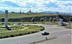 Buddha Statue complex | |
 Darkhan | |
| Coordinates: 49°28′08″N 105°57′27″E / 49.46889°N 105.95750°ECoordinates: 49°28′08″N 105°57′27″E / 49.46889°N 105.95750°E | |
| Country | Mongolia |
| Province | Darkhan-Uul Province |
| Founded | October 1961 |
| Area | |
| • Total | 103 km2 (40 sq mi) |
| Elevation | 665 m (2,182 ft) |
| Population (2017) | |
| • Total | 83,883 |
| • Density | 810/km2 (2,100/sq mi) |
| Time zone | UTC+8 (UTC + 8) |
| Postal code | 213800 |
| Area code(s) | +976 (0)137 |
| Vehicle registration | ДАx (x variable) |
| Climate | Dwb |
| Website | http://www.darkhan.mn/ |

Darkhan (Mongolian: Дархан, "blacksmith") is the third-largest city in Mongolia and the capital of Darkhan-Uul Aimag (Darkhan-Uul Province). It has a population of 96,428 in 2013.[1]
History[]
On October 17, 1961, the city of Darkhan was built with extensive economic assistance from the Comecon.[2] As its name implies, the city was originally conceived to be a manufacturing site for Mongolia's northern territory. Polish specialists built a woodworking plant, brickworks and a lime factory in Darkhan.[2] Hungarians built a meat factory, opened in 1974.[3]
The city remains a mostly industrial centre and is the home of some 82% of Darkhan-Uul Province's population. As with most urban Mongols, some 86% of the city's population live in residential apartments, with the remaining population living in yurts (gers) on the outskirts of the city.[citation needed]
Climate[]
Darkhan has a borderline humid continental climate (Dwb), close to the more typical subarctic climate (Dwc) of northern Mongolia, which is found in higher areas near the city, and only marginally wet enough to avoid qualifying as a semi-arid climate (BSk). These three climate types tend to overlap a good deal over the border regions of Mongolia, Russia and Kazakhstan.[4] This area has extremely cold and dry winters; however the summers are warmer and more humid.
| hideClimate data for Darkhan | |||||||||||||
|---|---|---|---|---|---|---|---|---|---|---|---|---|---|
| Month | Jan | Feb | Mar | Apr | May | Jun | Jul | Aug | Sep | Oct | Nov | Dec | Year |
| Average high °C (°F) | −18.7 (−1.7) |
−13.8 (7.2) |
−0.8 (30.6) |
10.6 (51.1) |
19.3 (66.7) |
24.6 (76.3) |
25.6 (78.1) |
23.2 (73.8) |
17.0 (62.6) |
7.8 (46.0) |
−4.6 (23.7) |
−15.2 (4.6) |
6.3 (43.3) |
| Daily mean °C (°F) | −24.7 (−12.5) |
−21.1 (−6.0) |
−8.3 (17.1) |
3.2 (37.8) |
11.2 (52.2) |
17.2 (63.0) |
19.2 (66.6) |
17.1 (62.8) |
9.9 (49.8) |
0.7 (33.3) |
−11.1 (12.0) |
−21.1 (−6.0) |
−0.6 (30.8) |
| Average low °C (°F) | −30.6 (−23.1) |
−28.3 (−18.9) |
−15.7 (3.7) |
−4.2 (24.4) |
3.1 (37.6) |
9.9 (49.8) |
12.9 (55.2) |
11.1 (52.0) |
2.8 (37.0) |
−6.3 (20.7) |
−17.6 (0.3) |
−27 (−17) |
−7.5 (18.5) |
| Average precipitation mm (inches) | 3 (0.1) |
2 (0.1) |
4 (0.2) |
8 (0.3) |
17 (0.7) |
59 (2.3) |
83 (3.3) |
75 (3.0) |
36 (1.4) |
12 (0.5) |
6 (0.2) |
4 (0.2) |
309 (12.3) |
| Source: http://en.climate-data.org/location/29830/ | |||||||||||||
Culture[]
The is housed in a log cabin in the old town; it has recently become active again as a Buddhist monastery.
In addition, the city hosts the . This museum, also called the Traditional Museum of Folk Art, contains a collection of archaeological findings, traditional clothing, religious artifacts, and taxidermy.
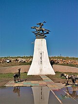
The city has a monument to the horse-head fiddle (morin khuur), the national emblematic instrument of Mongols.
Education[]
Darkhan is the second largest educational center in Mongolia, making the educational level of the city's population very high. Hundreds of students come to Darkhan from other parts of Mongolia to study. Currently in Darkhan Uul Aimag there are 10 higher education institutions, 25 secondary schools, 14 kindergartens, the Institute of Management and Development, the Regional Business Development Center and the Plant Science and Agricultural Training Research Institute.
Partner cities[]
Darkhan is partnered with:[5]
| City | State | Country |
|---|---|---|
| Dimitrovgrad | ||
| Zeitz | ||
| Irving | ||
| Kaposvár | ||
| Ulan Ude |
References[]
| Wikivoyage has a travel guide for Darkhan. |
- ^ "РЕГИОНЫ МОНГОЛИИ:ДАРХАН". Archived from the original on 2014-04-19. Retrieved 2018-08-13.
- ^ Jump up to: a b Gronowska, Ewa (8 October 1988). "Polska— Mongolia. Kraj daleki i bliski". Głos Pomorza (in Polish). No. 235. p. 3.
- ^ "Felavatták Mongóliában a magyar segítséggel épült darhani húskombinátot". Petőfi Népe (in Hungarian). No. 158. 9 July 1974. p. 1.
- ^ Updated Köppen-Geiger climate map
- ^ (in Bulgarian) Официален сайт на община Димитровград – Побратимени градове
| Authority control |
|---|
- 1961 establishments in Mongolia
- Populated places established in 1961
- Aimag centers
- Socialist planned cities