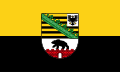
Saxony-Anhalt
Saxony-Anhalt
| |
|---|---|
 | |
| Coordinates: 51°58′N 11°28′E / 51.967°N 11.467°ECoordinates: 51°58′N 11°28′E / 51.967°N 11.467°E | |
| Country | Germany |
| Capital | Magdeburg |
| Government | |
| • Body | Landtag of Saxony-Anhalt |
| • Minister-President | Reiner Haseloff (CDU) |
| • Governing parties | CDU / SPD / Greens |
| • Bundesrat votes | 4 (of 69) |
| Area | |
| • Total | 20,451.58 km2 (7,896.40 sq mi) |
| Population (31 December 2018) | |
| • Total | 2,208,321 |
| • Density | 110/km2 (280/sq mi) |
| Time zone | UTC+1 (CET) |
| • Summer (DST) | UTC+2 (CEST) |
| ISO 3166 code | DE-ST |
| GRP (nominal) | €64 billion (2019)[1] |
| GRP per capita | €29,000 (2019) |
| NUTS Region | DEE |
| HDI (2018) | 0.908[2] very high · 16th of 16 |
| Website | sachsen-anhalt.de |


Saxony-Anhalt (German: Sachsen-Anhalt [ˌzaksn̩ ˈʔanhalt] (![]() listen); Low German: Sassen-Anholt) is a state of Germany, bordering the states of Brandenburg, Saxony, Thuringia and Lower Saxony. It covers an area of 20,447.7 square kilometres (7,894.9 sq mi)[3]
and has a population of 2.19 million inhabitants,[4] making it the 8th-largest state in Germany by area and the 11th-largest by population. Its capital is Magdeburg and its largest city is Halle (Saale).
listen); Low German: Sassen-Anholt) is a state of Germany, bordering the states of Brandenburg, Saxony, Thuringia and Lower Saxony. It covers an area of 20,447.7 square kilometres (7,894.9 sq mi)[3]
and has a population of 2.19 million inhabitants,[4] making it the 8th-largest state in Germany by area and the 11th-largest by population. Its capital is Magdeburg and its largest city is Halle (Saale).
The state of Saxony-Anhalt originated in July 1945 after World War II, when the Soviet army administration in Allied-occupied Germany formed it from the former Prussian Province of Saxony and the Free State of Anhalt. Saxony-Anhalt became part of the German Democratic Republic in 1949, but was dissolved in 1952 during administrative reforms and its territory divided into the districts of Halle and Magdeburg, with the city of Torgau joining the district of Leipzig. Following German reunification the state of Saxony-Anhalt was re-established in 1990 and became one of the new states of the Federal Republic of Germany.
Saxony-Anhalt is renowned for its rich cultural heritage and possesses the highest concentration of UNESCO World Heritage sites in Germany.
Geography[]
Saxony-Anhalt is one of 16 Bundesländer of Germany. It is located in the western part of eastern Germany. By size, it is the 8th largest state in Germany and by population, it is the 11th largest.
It borders four other Bundesländer: Brandenburg to the north-east, Saxony to the south-east, Thuringia to the south-west and Lower Saxony to the north-west.
In the north, the Saxony-Anhalt landscape is dominated by the flat expanse of the North German Plain. The old Hanseatic towns Salzwedel, Gardelegen, Stendal and Tangermünde are located in the sparsely populated Altmark. The Colbitz-Letzlingen Heath and the Drömling near Wolfsburg mark the transition between the Altmark region and the Elbe-Börde-Heath region with its fertile, sparsely wooded Magdeburg Börde. Notable towns in the Magdeburg Börde are Haldensleben, Oschersleben (Bode), Wanzleben, Schönebeck (Elbe), Aschersleben and the capital Magdeburg, from which the Börde derives its name.
The Harz mountains are located in the south-west, comprising the Harz National Park, the Harz Foreland and Mansfeld Land. The highest mountain of the Harz (and of Northern Germany) is Brocken, with an elevation of 1,141 meters (3,735 ft). In this area, one can find the towns of Halberstadt, Wernigerode, Thale, Eisleben and Quedlinburg.
The wine-growing area Saale-Unstrut and the towns of Zeitz, Naumburg (Saale), Weißenfels and Freyburg (Unstrut) are located on the rivers Saale and Unstrut in the south of the state.
The metropolitan area of Halle (Saale) forms an agglomeration with Leipzig in Saxony. This area is known for its highly developed chemical industry (the Chemiedreieck – chemical triangle), with major production plants at Leuna, Schkopau (Buna-Werke) and Bitterfeld. Finally, in the east, Dessau-Roßlau and Wittenberg are situated on the Elbe (as is the capital Magdeburg) in the Anhalt-Wittenberg region.
Administrative subdivisions[]


The capital of Saxony-Anhalt is Magdeburg. It is the second-largest city in the state, closely after Halle (Saale). From 1994 to 2003, the state was divided into three regions (Regierungsbezirke), Dessau, Halle and Magdeburg and, below the regional level, 21 districts (Landkreise). Since 2004, however, this system has been replaced by 11 rural districts and three urban districts.[5]

The counties are:
- Altmarkkreis Salzwedel
- Anhalt-Bitterfeld
- Börde
- Burgenlandkreis
- Harz
- Jerichower Land
- Mansfeld-Südharz
- Saalekreis
- Salzlandkreis
- Stendal
- Wittenberg
The independent cities are:
- Dessau-Roßlau
- Halle (Saale)
- Magdeburg
Largest towns[]
The largest towns in Saxony-Anhalt according to a 31 December 2017 estimate:[6]
| Rank | City | Population |
|---|---|---|
| 1 | Halle | 239,173 |
| 2 | Magdeburg | 238,478 |
| 3 | Dessau-Roßlau | 82,111 |
| 4 | Lutherstadt Wittenberg | 46,272 |
| 5 | Weißenfels | 40,874 |
| 6 | Halberstadt | 40,871 |
| 7 | Stendal | 39,822 |
| 8 | Bitterfeld-Wolfen | 39,103 |
| 9 | Merseburg | 34,197 |
| 10 | Bernburg | 32,876 |

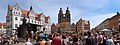
Halle is the largest city in Saxony-Anhalt.

Magdeburg with Magdeburg Cathedral
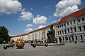
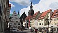
Dessau market square
Inside the old town of Wittenberg, a UNESCO World Heritage Site

Halberstadt with its churches

Merseburg with its castle and cathedral

Castle in Wernigerode


History[]

Saxony-Anhalt is a federal state with a relatively short history, if compared to other German federal states. It was formed in 1945 out of former Prussian territories and mainly consists of three distinct historical regions: the area around Magdeburg, the formerly independent Anhalt and a southern part which once was part of Saxony but had been annexed by Prussia in the 19th century. This historical origin can still be seen in the coat of arms of the federal state.
In April 1945 the US Army took control of most of the western and northern area of the future Saxony-Anhalt. The U.S. Group Control Council, Germany (a precursor of the OMGUS) appointed the first non-Nazi officials in leading positions in the area. Erhard Hübener, put on leave by the Nazis, was reappointed Landeshauptmann (state governor). By early July the US Army withdrew from the former Prussian Province of Saxony to make way for the Red Army to take it as part of the Soviet occupation zone, as agreed by the London Protocol in 1944.
On 9 July the Soviet SVAG ordered the merger of the Free State of Anhalt, Halle-Merseburg, the governorate of Magdeburg (in its then borders), Allstedt (before Thuringia) and some Brunswickian eastern exclaves and salients (Calvörde and the eastern part of the former Blankenburg district[7]) with the Province of Saxony.[8] The previously Saxon had become a part of Thuringia.
Anhalt takes its name from Anhalt Castle near Harzgerode; the origin of the name of the castle remains unknown. Anhalt was once an independent German federal state dating back for centuries.
The SVAG appointed Hübener as president of the provincial Saxon administration, a newly created function. The administration was seated in Halle an der Saale, which became the capital, also of later Saxony-Anhalt until 1952. On 3 September 1945 the new administration enacted by Soviet-inspired ordinance the mass expropriations, mostly hitting holders of large real estates, often of noble descent.
On the occasion of the first (and one and only) election in the Soviet zone, allowing parties truly to compete for seats in provincial and state parliaments, on 20 October 1946, the Province of Saxony was renamed as the Province of Saxony-Anhalt (German: Provinz Sachsen-Anhalt), taking the prior merger into account.[8] On 3 December 1946 the members of the new provincial parliament elected Hübener the first minister-president of Saxony-Anhalt with the votes of CDU and Liberal Democratic Party of Germany (LDPD). Thus he became the only governor in the Soviet zone, who was not a member of the communist Socialist Unity Party of Germany (SED). He was an inconvenient governor for the Soviet rulers.
After the official Allied decision to dissolve the Free State of Prussia, which had remained in limbo since the Prussian coup of 1932, its former provinces, in as far as they still existed, achieved statehood, thus the province emerged into the State of Saxony-Anhalt on 6 October 1947.[8] It became part of the German Democratic Republic (East Germany) in 1949. From 1952 on the East German states were dissolved, and Saxony-Anhalt's territory was divided into the East German districts of Halle and Magdeburg, except that the territory around Torgau was assigned to Leipzig. In 1990, in the course of German reunification, the districts were reintegrated as a state. But, territory around Torgau did not return to the state and joined Saxony. Now, Torgau is the centre of Nordsachsen district (since 2008).
In 2015 the skeletal remains of an ancient inhabitant of Karsdorf dated from the Early Neolithic (7200 BP) were analysed; he turned out to belong to the paternal T1a-M70 lineage and maternal lineage H1.[9][10]
Demographics[]
Since German reunification, there has been a continuous downward trend in the population of Saxony-Anhalt. This is partly due to outward migration and partly because the death rate exceeds the birth rate. Although the birth rate has been steady since 1994, the net reproduction rate is only approximately 70%. However, the total fertility rate reached 1.50 in 2014, the highest value since 1990.
| Year | Population | Change |
|---|---|---|
| 1990 | 2,873,957 | |
| 1995 | 2,738,928 | −135,029 |
| 2000 | 2,615,375 | −123,553 |
| 2005 | 2,469,716 | −145,659 |
| 2010 | 2,335,006 | −134,710 |
| 2015 | 2,245,470 | −89,536 |
Religion[]
The region has historically been associated with the Lutheran faith, but under Communist rule, church membership was strongly discouraged and much of the population disassociated itself from any religious body. Saxony-Anhalt contains many sites tied to Martin Luther's life, including Lutherstadt Eisleben and Lutherstadt Wittenberg.
In 2018, the majority of citizens in Saxony-Anhalt were irreligious and more were leaving the churches than entering them[12] – in fact, Saxony-Anhalt is the most irreligious state in Germany. 15.2% of the Saxon-Anhaltish adhered to the major denominations of Christianity (11.9% were members of the Evangelical Church in Germany and 3.3% were Catholics),[13] 2% were members of other religions[12] (mostly Islam, Judaism, the New Apostolic Church and Mandeism). 82.8% of the citizens of Saxony-Anhalt were religiously unaffiliated.[12][13] As of July 2019 there were 1,892 Jehovah's Witnesses (publishers) in Sachsen-Anhalt. Originally their branch office for Germany was in Magdeburg. When World War II ended in 1945, the property in Magdeburg, then part of East Germany, was returned and the branch was reestablished. But on August 30, 1950, Communist police stormed the facilities and arrested the workers, and the Jehovah's Witnesses in the German Democratic Republic (DDR) were banned.
Foreigners[]
The percentage of foreigners in Saxony-Anhalt was 4.9 percent by 31 December 2018, the third lowest among the 16 states of Germany (together with Saxony and Thuringia).[14]
The largest foreign resident groups by 31 December 2019 were:[15]
| 23,390 | |
| 11,200 | |
| 8,240 |
Politics[]
List of minister presidents[]
Landtag[]
13 March 2016 state election[]

| Party | Popular vote | Seats | ||||||||
|---|---|---|---|---|---|---|---|---|---|---|
| Votes | % | +/– | Seats | +/– | ||||||
| Christian Democratic Union Christlich Demokratische Union Deutschlands – CDU |
334,123 | 29.8 | 30 | |||||||
| Alternative for Germany Alternative für Deutschland – AfD |
271,832 | 24.2 | 24 | |||||||
| The Left Die Linke |
183,296 | 16.3 | 17 | |||||||
| Social Democratic Party of Germany Sozialdemokratische Partei Deutschlands – SPD |
119,377 | 10.6 | 11 | |||||||
| Alliance '90/The Greens Bündnis 90/Die Grünen |
58,226 | 5.2 | 5 | |||||||
| Free Democratic Party Freie Demokratische Partei – FDP |
54,525 | 4.9 | – | – | ||||||
Freie Wähler |
24,287 | 2.2 | – | – | ||||||
| National Democratic Party of Germany Nationaldemokratische Partei Deutschlands – NPD |
21,211 | 1.9 | – | – | ||||||
| Animal Protection Party Tierschutzpartei |
16,613 | 1.5 | – | – | ||||||
| Tierschutzallianz |
11,629 | 1.0 | – | – | ||||||
| Alliance for Progress and Renewal Allianz für Fortschritt und Aufbruch – ALFA |
10,471 | 0.9 | – | – | ||||||
| Other parties | – | 1.5 | – | – | ||||||
| Valid votes | 1,122,814 | 97.8% | ||||||||
| Invalid votes | 24,671 | 2.2% | ||||||||
| Totals and voter turnout | 1,147,485 | 87 | ||||||||
| Electorate | 1,878,095 | 100.00 | — | |||||||
| Source: Landeswahlleiterin[16] | ||||||||||
Minister-president Reiner Haseloff (CDU) retained his position in a coalition with former partner SPD and the Greens.
Economy[]
The Gross domestic product (GDP) of the state was 62.7 billion euros in 2018, accounting for 1.9% of German economic output. GDP per capita adjusted for purchasing power was 26,000 euros or 86% of the EU27 average in the same year. The GDP per employee was 88% of the EU average. The GDP per capita was the second lowest of all German states.[17]
Development[]
Saxony-Anhalt was part of the communist German Democratic Republic. After the breakdown of communism and the German reunification in 1990, the collapse of non-competitive former GDR industries temporarily caused severe economic problems. In 2000, Saxony-Anhalt had the highest unemployment rate of all German states, at 20.2%.[18]
However, the process of economic transformation towards a modern market economy seems to be completed. Massive investments in modern infrastructure have taken place since 1990, and the remaining and newly created businesses are highly competitive. For example, the industry has doubled its share of international revenue from 13 percent in 1995 to 26 percent in 2008.[19] Meanwhile, the unemployment rate has fallen considerably.[20] By 2010 the GDP of Saxony-Anhalt was almost two and a half times higher than it was in 1991.[21]
Even though part of this recovery was induced by the quite good performance of the Germany economy, Saxony-Anhalt did not only follow the national trend, but clearly outperformed other German states. For example, it got ahead of three German states in terms of unemployment (10.8%, as of September 2011): the German capital and city-state of Berlin (12.7%), the city-state Free Hanseatic City of Bremen (11.3%) and Mecklenburg-Western Pomerania (11%).[22]
The unemployment began to fall under 10% in 2016 and stood at 7.1% in October 2018.[23]
| Year[24] | 2000 | 2001 | 2002 | 2003 | 2004 | 2005 | 2006 | 2007 | 2008 | 2009 | 2010 | 2011 | 2012 | 2013 | 2014 | 2015 | 2016 | 2017 |
|---|---|---|---|---|---|---|---|---|---|---|---|---|---|---|---|---|---|---|
| Unemployment rate in % | 20.2 | 19.7 | 19.6 | 20.5 | 20.3 | 20.2 | 18.3 | 15.9 | 13.9 | 13.6 | 12.5 | 11.6 | 11.5 | 11.2 | 10.7 | 10.2 | 9.6 | 8.4 |
Structure[]
- The chemical industry is quite important, with almost 25,500 employees across 214 plants in 2010.[25] One of the biggest chemical producing areas can be found around the city of Bitterfeld-Wolfen. Because of the chemical industry, Saxony-Anhalt attracts more foreign direct investments than any other state in eastern Germany.
- The state is the location of numerous wind farms producing wind-turbine energy.
- Saxony-Anhalt is also famous for its good soil. Hence, the food industry has an important role with almost 19,500 employees across 190 plants in 2010.[25] Some of the best known products are Baumkuchen from Salzwedel and Halloren chocolate globes from Germany's oldest chocolate factory in Halle.
Tourism[]
Saxony-Anhalt has seven World Heritage Sites, the highest number of all states in Germany.[26]
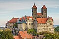
Collegiate church, castle, and the old town of Quedlinburg
Luther memorials in Wittenberg
Luther memorials in Eisleben
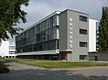
Bauhaus Dessau


Anthem[]
- Lied für Sachsen-Anhalt ("Song for Saxony-Anhalt")
- Motto: Land of the Early Risers
See also[]
References[]
- ^ "Bruttoinlandsprodukt – in jeweiligen Preisen – 1991 bis 2019". statistik-bw.de. Archived from the original on 25 June 2020. Retrieved 26 June 2019.
- ^ "Sub-national HDI – Area Database – Global Data Lab". hdi.globaldatalab.org. Retrieved 13 September 2018.
- ^ "Archived copy". Archived from the original on 19 July 2011. Retrieved 1 February 2011.CS1 maint: archived copy as title (link)
- ^ Statistisches Landesamt Sachsen-Anhalt
- ^ District reform law Archived 19 July 2011 at the Wayback Machine 11 November 2005 (in German)
- ^ "Archived copy" (PDF). Archived from the original (PDF) on 19 August 2014. Retrieved 16 August 2014.CS1 maint: archived copy as title (link)
- ^ The latter, however, a salient originally not assigned as part of the Soviet zone, was unilaterally handed over by the Britons only on 22 July.
- ^ Jump up to: a b c "1945–1949", on: Gedenkkultur Dessau-Roßlau Archived 26 August 2011 at the Wayback Machine. Retrieved on 16 August 2011.
- ^ Marres, E.C.W.L. (Boed). "Our Far Forebears". www.marres.education. Archived from the original on 12 September 2017. Retrieved 1 May 2018.
- ^ Massive migration from the steppe is a source for Indo-European languages in Europe
- ^ Statistisches Landesamt Sachsen-Anhalt. "Bevölkerungsentwicklung seit 1966" (in German). statistik.sachsen-anhalt.de. Retrieved 4 May 2020.
- ^ Jump up to: a b c [1] Archived 17 March 2012 at the Wayback Machine
- ^ Jump up to: a b Evangelische Kirche in Deutschland – Kirchemitgliederzahlen Stand 31. Dezember 2018 EKD, January 2020
- ^ "Ausländische Bevölkerung". statistikportal.de (in German). 17 July 2019. Retrieved 4 May 2020.
- ^ "1/3 der Ausländerinnen und Ausländer im Rahmen der EU-Freizügigkeit in Sachsen-Anhalt". statistik.sachsen-anhalt.de (in German). 8 April 2020. Retrieved 4 May 2020.
- ^ "Wahl des 7. Landtages von Sachsen-Anhalt am 13. März 2016 – Vorläufiges Ergebnis" (in German). Landeswahlleiterin Sachsen-Anhalt. 13 March 2016. Archived from the original on 14 March 2016. Retrieved 14 March 2016.
- ^ "Regional GDP per capita ranged from 30% to 263% of the EU average in 2018". Eurostat.
- ^ Statistisches Landesamt Sachsen-Anhalt (29 January 2014). "Statistical Office of the State of Saxony-Anhalt (2010)". Statistik.sachsen-anhalt.de. Archived from the original on 19 August 2014. Retrieved 16 August 2014.
- ^ Chamber of Commerce and Industry of Halle-Dessau (2010), p. 14[dead link]
- ^ "Chamber of Commerce and Industry of Berlin (2011), p. 2" (PDF) (in German). Retrieved 16 August 2014.
- ^ "(2010)". fDi Atlas. Retrieved 16 August 2014.
- ^ "Chamber of Commerce and Industry of Berlin". 2011. p. 2. Archived from the original on 1 February 2014. Retrieved 16 August 2014.
- ^ "Arbeitslosenquote nach Bundesländern in Deutschland 2018 | Statista". Statista (in German). Retrieved 13 November 2018.
- ^ (Destatis), Statistisches Bundesamt (13 November 2018). "Federal Statistical Office Germany – GENESIS-Online". www-genesis.destatis.de. Retrieved 13 November 2018.
- ^ Jump up to: a b fDi Atlas (2010)
- ^ "Denkmäler in der UNESCO Liste des Welterbes in Deutschland nach Bundesland 2019". Statista (in German). Retrieved 19 May 2020.
External links[]
| Wikimedia Commons has media related to Saxony-Anhalt. |
| Wikivoyage has a travel guide for Saxony-Anhalt. |
- Official governmental portal
- Official Directory
 Geographic data related to Saxony-Anhalt at OpenStreetMap

| show Authority control |
|---|
- Saxony-Anhalt
- NUTS 1 statistical regions of the European Union
- States and territories established in 1990
- 1990 establishments in Germany