Altai flood
Coordinates: 50°17′07″N 87°40′16″E / 50.28528°N 87.67111°E


The Altai flood refers to the cataclysmic flood(s) that, according to some geomorphologists, swept along the Katun River in the Altai Republic at the end of the last ice age. These glacial lake outburst floods were the result of periodic sudden ruptures of ice dams like those triggering the Missoula floods.
Background[]
In the USA, large glacial outburst floods have been researched since the 1920s.[1] In the 1980s, Russian geologist Alexei N. Rudoy proposed the term diluvium for deposits created as a result of catastrophic outbursts of Pleistocene giant glacier-dammed lakes in intermontane basins of the Altai.[2] The largest of these lakes (the conjoined Chuya and Kuray) had a water volume of hundreds of cubic kilometers.[3]
Evidence[]
Gravel ripples[]
Giant current ripples (gravel wave trains, diluvial dunes and antidunes) up to 18 meters high and 225 meters in wavelength were created in several locations along the lake bottom. They are best developed just east of the Tyetyo River in the eastern part of the Kuray Basin, but several other smaller fields of giant current ripples also occur there. They are made up of rounded pebble gravel.
Giant bars[]
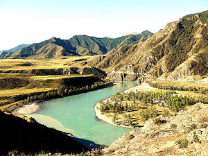
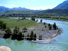
Giant bars are found along the lower Chuya River and the Katun River, rising as much as 300m above modern river levels, with lengths up to five kilometers. Well-developed on the Katun River below its confluence with the Chuya River, the bars appear to have formed like giant point bars on the inner bends of the river, as opposed to the scoured bare bedrock walls of the ‘cut bank’ on the outer bends. These bars diminish in height and thickness downstream to about 60 m near Gorno-Altaisk.

Some of these bars form lakes when blocking small tributaries of the Katun.
Suspension gravels[]

Much of the gravel deposited along the Katun valley lacks a stratigraphic structure, showing characteristics of a deposition directly after suspension in a turbulent flow.
Large blocks[]
Unique block deposits (diluvial berms of Rudoy) cap erosional terraces that are a few kilometers long, tens of meters wide, and about 4 m above the lower bars. Block sizes range up to 20 m on the long axis, and show no evidence of rounding [Fig. 31]. Cuspate erosional hollows and accumulation ridges are associated with individual blocks. Rudoy [2003, pers. comm.] estimates the discharge required to transport these blocks in suspension was about 1 million m3, with a duration of maximum flow of about 10 minutes.
Ice-rafted blocks[]
Ice-rafted boulders up to several meters in diameter.
Eddy deposits[]
Eddy deposits are seen along the Katun River between Inya and Mali Yaloman.
Multiple flood hypothesis[]
Dating of the gravel bars has yielded at least 3 times of deposition, suggesting that multiple floods occurred.
The current understanding[]

Towards the end of the last glacial period, 12,000 to 15,000 years ago, glaciers descending from the Altai mountains dammed the Chuya River, a large tributary of the Katun River, creating a large glacial lake including the Chuya and the Kurai basins.[4][5] As the lake grew larger and deeper, the ice dam eventually failed, causing a catastrophic flood that spilled along the Katun River. This flood may have been the greatest discharge of freshwater on Earth, since its magnitude has been estimated similar to that of the Missoula flood in North America.
Timing[]
The age[s] of catastrophic flooding is not tightly constrained, and may involve several events. The mechanisms of lake filling and ice dam failure would suggest an early or late glacial time, whereas conditions at glacial maxima would seem to preclude such events. The catastrophic flood(s) occurred between 12000 BC and 9000 BC.
Most of the water discharge is thought to have occurred during one day, with peak discharges of 107 m3/s (Herget, 2005). The maximum lake volume was 6x10¹¹ m3 (600 km3) with an area of 1.5x10⁹ m2. The ice dam was about 650 m high.
Flood route[]
When the ice dam failed, floodwaters coursed down the Chuya River to the confluence with the Katun River, followed the Katun into the Ob River, and then into Lake Mansi, a large proglacial Pleistocene lake, ~600,000 km2 in area. The fast inflow raised its level by only ~12 m but some authors argue that, because the Turgay spillway of Lake Mansi was only 8 m above the lake level at the time, much of the floodwater continued into the Aral Sea. From there the flooding waters may have followed through the Uzboy spillway into the Caspian Sea, then through the Manych spillway into the Black Sea, and eventually into the Mediterranean Sea.[6][7]
See also[]
- Diluvium – Deposits created as a result of catastrophic outbursts of Pleistocene giant glacier-dammed lakes
- Giant current ripples – Depositional forms in diluvial plain and mountain scablands
- Missoula Floods
- Outburst flood – High-magnitude, low-frequency catastrophic flood involving the sudden release of water
References[]
- ^ V.R. Baker. The Spokane Flood debates: historical background and philosophical perspective //Geological Society, London, Special Publications 2008; v. 301; p. 33-50.
- ^ Lee, Keenan, 2004, The Altai Flood Archived 2011-10-09 at the Wayback Machine
- ^ "Rudoy, A.N., Glacier-dammed lakes and geological work of glacial superfloods in the Late Pleistocene, Southern Siberia, Altai Mountains, Quaternary International, 2002, Vol. 87/1, pp. 119-140". Archived from the original on 2012-08-19. Retrieved 2011-10-14.
- ^ "Rudoy, A.N., Baker, V. R. Sedimentary effects of cataclysmic late Pleistocene glacial outburst flooding, Altay Mountains, Siberia // Sedimentary Geology, 85 (1993) 53-62". Archived from the original on 2011-09-15. Retrieved 2011-10-14.
- ^ Baker, V. R., G. Benito, A. N. Rudoy, Paleohydrology of late Pleistocene Superflooding, Altay Mountains, Siberia, Science, 1993, Vol. 259, pp. 348-352
- ^ Rudoy A.N. Mountain Ice-Dammed Lakes of Southern Siberia and their Influence on the Development and Regime of the Runoff Systems of North Asia in the Late Pleistocene. Chapter 16. (P. 215—234.) — Palaeohydrology and Environmental Change / Eds: G. Benito, V.R. Baker, K.J. Gregory. — Chichester: John Wiley & Sons Ltd, 1998. 353 p.
- ^ Grosswald, M.G., 1998, New approach to the ice age paleohydrology of northern Eurasia. Chapter 15. (P. 199-214)— Palaeohydrology and Environmental Change / Eds: G. Benito, V.R. Baker, K.J. Gregory. — Chichester: John Wiley & Sons Ltd, 1998. 353 p.
External links[]
- Geology of Asia
- Megafloods