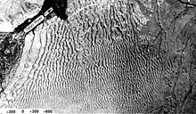
Giant current ripples

Giant current ripples are active channel topographic forms up to 20 m high, which develop within near-talweg areas of the main outflow valleys created by glacial lake outburst floods. Giant current ripple marks are large scale analogues of small current ripples formed in sandy stream sediments.
The giant current ripple marks are important depositional forms in diluvial plain and mountain scablands.[1]
Descriptive features[]
Up to the present, hundreds of locations of the fields of giant current ripples have been discovered in North America and Northern Asia. Here is a brief description of main characteristics of this relief and its sediments at the key, today most often visited, sites in the Altai and Tuva with the necessary references to the chief publications for the other territories.
- Wave height from 2–20 m with the wavelength from 5–10 m to 300 m
- Ripple marks are stretched transversely to the diluvial floods. They are clearly and regularly asymmetric. The proximal slopes are oriented towards the flood, they are more gentle with slightly prominent profiles (The profile of "the whale back"); the distal slopes are steeper with slightly concave profiles nearer to the crest
- Big poorly rounded boulders and blocks are often to be found at pre-crest and upper part of the slopes
- Giant current ripple marks are constituted by deposits of pebbles and small boulders with a low percentage of coarse- and big-grained sand. The fragmentary material is diagonally cross-bedded agreed with the dip of the distal slope. Irrespective of the age of the ridges (normally, it is the time of the last late- and post-glacial age) the sediments are loose and dry, fragments are not hardened with loamy and silt.
- Fields of giant current ripples are situated close to the run-off ways from basinal ice-dammed lakes and to vortex zones within valley expansions[2]
Unfortunately, no diagnostic features of the lithology of giant current ripples have been cleared up, yet, that could differentiate the latter from other genetic types of loosed sediments in sections. The presence of cross-bedded series in some layers with evidently fluvial origin were identified by V.V. Butvilovsky as buried ripples. Nothing, except the fact of the cross dipping of fluvial boulder pebbles, can tell the investigator that he sees some buried giant current ripple. The problem of diagnosing diluvial sediments in a buried state, i.e., without any geomorphological control, may apparently be solved not only, if at all, by studying peculiarities of the diluvial texture, but by means of the microscopic lithological studies of the sediments of giant current ripples, i.e., mineralogy of fine fractions, grain shapes, analysis of accessories, etc. Then these correctly summarised data must be compared with various phases of the contemporary mountainous alluvium at the analogous sections.
Research History[]

The history of the scabland studies has two distinct stages: the "old" one that began with the first works by J Harlen Bretz and Joseph Pardee in North America and lasted until the end of the 20th century that was crowned with the discovery of giant current ripple marks in Eurasia, and a "new" one. The latter is associated with heated debates concerning the genesis of the relief under study and which involved a lot of Russian geologists, geomorphologists and geographers. The discussion about the origin of the giant ripples dealt at least to a certain extent with every aspect of the diluvial theory, from the genesis of the lakes themselves, their existence duration, possibilities of their cataclysmic failures, etc. to the origin of the diluvial forms – the aspects that have been accepted by many scientists worldwide.[citation needed]
The state of the problem in the 20th century. "Old hypotheses"[]
J Harlen Bretz, author of the hypothesis of the diluvial origin of the Channeled Scabland, considered mainly "giant gravel bars" (diluvial ramparts and terraces) among the diluvial-accumulative formations as a proof of his case along with the destructive forms of the scabland (gorges-coulees, waterfall cataracts – chains of erosional washed of loose sediments by the floods of diluvial farewell rocks).[3][4][5]

It was only after J. T. Pardee's report in Seattle at the Session of the American Association for the Advancement of Science in 1940[6] that the expression "giant current ripples" was introduced in the modern meaning. J. Pardee gave brief characteristics to the forms found by him already in the early 20th century while researching the Late Pleistocene lake Missoula.[7] After Pardee's publication in 1942, giant current ripples have been found practically everywhere on the basaltic Columbia Plateau (this was the direction of the cataclysmic outbursts of Missoula and other ice-dammed lakes).
A special study of the geomorphology and palaeohydrology of the American scabland was begun by Victor Baker.[8] Baker mapped all main fields of giant current ripples known today in America. He also made first attempts to ascertain the hydraulic characteristics.[9] Baker calculated the palaeohydraulic data over the ripple fields, i.e., over the sites distanced from the channel line and (or) on wane of the floods, where the current velocities of the diluvial streams admittedly must have been less than maximum ones (all the same, they were hundreds of thousands of cubic metres per second).[citation needed]
For nearly sixty years Lake Missoula was considered a unique case in scientific literature. Special tourist routes were organised at most impressive sites of "giant vessels", canyons-coulees, vast fields of giant current ripples and others.[citation needed]

Along with the development of the idea of Pleistocene glacier-dammed lakes and their cataclysmic outbursts, a new branch of scientific research called "flood deposit sedimentology"[10] is becoming more and more notable.
In Russia nobody had known anything about ice-dammed lakes until the 1980s and, of course, had not looked for any traces of their failures, either. Although some lake terraces of glacial age in the mountains of South Siberia were mapped in the early 20th century as part of unrelated geological research the question of the evacuation mechanisms of these lakes never arose. The assumption was that the lakes dried up gradually.
In the late 1950s G. F. Lungershausen and O. A. Rakovets[11] were the first to interpret a ridge-and-pading relief in Kuray intermountain depression as caused by flooding.
New hypotheses of the origin of the giant current ripple marks[]
The first investigator in Russia who not only correctly defined the genesis of the giant current ripples (we shall remind that this was done first by G.F. Lungershausen and O.A. Rakovets about twenty-five years before that time) but also described their composition and reconstructed (in a complex with other flood forms) palaeoglaciohydrology of the region of the geological surveys was V.V. Butvilovsky in the valley of the Bashkaus River in the Easter Altai. V.V. Butvilovsky described the whole palaeohydrologic scenario of the last glacial age based on a small district, which corresponds well to the modern ideas about glacial palaeohydrology of the dryland. He showed that the Quaternary ice-dammed lake of Tuzhar Village outburst into the valley of the Chulyshman River after having reached its critical level. He emphasised that in the valley of the Bashkaus River and the Chulyshman River there was only one very powerful superflood with a maximum discharge of about 880 000 m3/s. [Butvilovsky, 1993].[12]
Altay, studied the largest ice-dammed lakes in the altai, those of the Chuya, Kuray and Uymon Basins[13] The result of the research was the first published work dedicated to the multiple cataclysmic outbursts of Pleistocene ice-dammed lakes.[14] That work was the first to give a detailed description of the structure of the relief of the giant current ripples at the foothills.


Some reconstruction of the regime of the , estimates of the glacial runoff at its maxima and post-maxima, on the one hand, and the discovery of the diluvial morpholithocomplex on the other hand, enabled us already at the late 1980s to outline a common palaeoglaciohydrologic situation of the Glacial Pleistocene for those territories of the Earth where the climatic conditions were similar to those of the mountains of Siberia. At the same time M.G. Grosswald[15] described and physically interpreted for the first-time fields of giant current ripples not in the Altai only but also in the intermountain depressions of Tuva and in the valleys of the Upper Yenisei. Nowadays these fields are also studied by international expeditions, some works paying a special attention to the giant ripple marks on the Sayany-Tuva table-land have been already published.[16]
In early 1990s first international expeditions which specially studied the diluvial morpholithologic complex in Asia. Their purpose was to compare main palaeohydromorphologic characteristics of mountain scablands of Central Asia which had been already developed in Russia by that time[17] with those of the known plain diluvial associations of the Channeled Scabland territory in North America. The participants of those first expeditions were specialists from Russia (M.R. Kirianova, A.N. Rudoy), the United States (V.R. Baker), Great Britain (P.A. Carling), Germany (K. Fischer and M. Kuhle) and Switzerland (Ch. Siegenthaler).[18]
In the second half of 1990s and at the beginning of the 21st century (until the field season of 2010) P.A. Carling carried out some more special expeditions in the Altai, their results were summed up in a cooperative work.[19]
Later, a group of German sedimentologists under the direction of Ju. Herget worked successfully in the Altai. Several big articles presented the refined data of the palaeohydraulic parameters of the diluvial floods in the river valleys of the Chuya River and Katun River.[20]
In 1998 S.V. Parnachov defended his candidate thesis based on the analysis of some well-known sections of the diluvial terraces at the Katun River and the Chuya River, as well as on the data by P.A. Carling and conclusions of his own. The thesis paid a certain amount of attention to the key locations of the fields of giant current ripples discovered before. The investigator fulfilled, in particular, the petrographic and granulometric analyses of the clastic material of the giant ripples at the key sites. S.V. Parnachov based himself on the calculations of the jökulhlaup discharges by P.A. Carling – 750,000 m3 per second – and came to the conclusion that there were no fluvial catastrophes but there were several lake outbursts with the discharges not higher than those of contemporary big rivers. Instead of the diluvial sediments this author suggested a new geological formation – the "flood alluvium".[21]
Consequently, S.V. Parnachov distinguished the "flooding period" in the Altay of about 150 000 years long. Two years later I.S. Novikov and Parnachov came to the conclusion that glaciers alone could not produce lakes of this size. Consequently, the dams were "ice-tectonic" ones. So, during the "flooding period" that lasted for about 150 000 years there were no less than seven cataclysmic flooding occurrences associated with the outbursts of the palaeolakes. Moreover, a tectonic obstacle also played a role in the damming of the lakes during the very last degradation phases of the Würm glacier.[22]
Alternate explanations[]
"New antidiluvialists" have put forth alternate explanations to the giant current ripples theory.[23]
- The giant current ripples in the valleys of the Altai (except Kuray depression) are ordinary ripples like contemporary river dunes of large rivers (i.e. – "nothing special"). The author of the quotation is A.V. Pozdniakov who observed some forms of such ripples in the valleys in the Far East. He was joined by D.A. Timofeev[24] and some participant of a school-seminar of the geography Committee of the Russian Academy of Sciences,[25] including G. Ya. Baryshnikov who, 10 years earlier, proved the cataclysmic origin of the giant current ripple marks at the foothills of the Altai and at the middle reaches of the Katun.
- The giant current ripples in Kuray depression are ripples but they developed "under the conditions which were similar to or slightly different from the contemporary ones, and not on the bottoms of the deep pre-glacial lakes which outburst catastrophically". Quoted from an essay in "The Geomorphology" written by G. Ya. Baryshnikov and others with references to the opinion of the participants of the above-mentioned school-seminar adopted after the discussion.
- The giant current ripples in Kuray depression are not ripples at all but the consequence of a meteorite fall.
- The giant current ripples in Kuray depression are not ripples at all but the consequence of an earthquake. These hypotheses contain both elastic vibrations and cryptoexplosion structures... The authors are A.V. Pozdniakov and A.V. Khon.[26]
- The giant current ripples in Kuray depression are cryogenic erosional formations. The authors are A.V. Pozdniakov and A.V. Khon again, also P.A. Okishev.[27]
Megaflooding on Earth and Mars[]

American and British geologists and planetologists have discovered giant current ripple reliefs on Mars, indicating megafloods have occurred there at some point in the past[29]
References[]
- ^ Alexei N. Rudoy, 2005. Giant current ripples (History of the Research, their diagnostics and palaeogeographical significance). - Tomsk. - 224 pp. In Russian, Eng. summary: pp. 134–211 pp.
- Рудой А. Н. Гигантская рябь течения (история исследований, диагностика и палеогеографическое значение) // Материалы гляциологических исследований, 2006. — Вып. 101. — С. 24–48.
- ^ Рудой А.Н. Гигантская рябь течения (история исследований, диагностика и палеогеографическое значение) – Томск: ТГПУ, 2005. - 228 с. (Abstr. in eng. on pp. 134–221).
- ^ Bretz, J.H. "The Channeled Scabland of the Columbia Plateau", Geol. Soc. Am. Bull., 1923. - Vol. 31.- p. 617–649
- ^ Bretz, J. H., "The Spocan beyond the Channeled Scabland", J. Geol., 1925. V. 33. p. 97–115
- ^ Bretz, J.H., Smith, H.T., U., Neff, G.E., "Channeled Scabland of Washington; new data and interpretations", Geol. Soc. America Bull., 1956. - V. - 67. P. 957–1049
- ^ Pardee, J. T., "Unusual currents in glacial Lake Missoula, Montana", Geol. Soc. Am. Bull., 1942. - V. 53. - P. 1569–1600.
- ^ Pardee, J.T., "The glacial Lake Missoula, Montana", J. Geol., 1910.- V. 18. - P. 376–386.
- ^ Baker, V. R. Paleohydrology and sedimentology of Lake Missoula Flooding in Eastern Washington, Gel. Soc. Am. Spec. Pap., 1973. - V. 6. - 79 p.
- ^ Baker, V. R. and D. Nummedal, The Channeled Scabland, NASA, Washington, D.C., 1978. - 186 p.
- ^ Carling P. A., Kirkbride A.D., Parnachov S.P et al. Late Quaternary catastrophic flooding in the Altai Mountains of south-central Siberia: a Synoptic overview and an introduction to the flood deposit sedimentology / Eds. P.I. Martini, V.R. Baker, G. Garson. – In: Flood and megaflood processes and deposits: resend and ancient examples // Int. Ass. of Sedimentologists. Oxford, England, 2002. Spec. Publ. 32. p. 17–35.
- ^ Лунгерсгаузен Г.Ф., Раковец О.А. Некоторые новые данные о стратиграфии третичных отложений Горного Алтая // Тр. ВАГТ, 1958. Вып. 4. 1958. С. 79–91.
- ^ Бутвиловский В.В. О следах катастрофических сбросов ледниково-подпрудных озер Восточного Алтая // Эволюция речных систем Алтайского края и вопросы практики. - Барнаул, 1982. С. 12–17.
- ^ Рудой А.Н. К истории приледниковых озер Чуйской котловины (Горный Алтай). – Материалы гляциологических исследований. Хроника, обсуждения, 1981. Вып. 41. С. 213–218.
- Рудой А.Н. Некоторые вопросы палеогеографический интерпретации литологии и особенностей распространения озерно-ледниковых отложений Горного Алтая // Гляциология Сибири, 1981. Томск: Томский ун-т. Вып. 1 (16). С. 111–134.
- Рудой А.Н. К диагностике годичных лент в озерно-ледниковых отложениях Горного Алтая // Изв. Всесоюзного географического общества, 1981. Т. 113. Вып. 4. С. 334–340.
- Рудой А.Н. Гигантская рябь течения - доказательство катастрофических прорывов гляциальных озер Горного Алтая / Научн.-практ. конф. "Современные геоморфологические процессы на территории Алтайского края". - Бийск, 1984. - С. 60–64.
- ^ Рудой А.Н. Гигантская рябь течения – доказательство катастрофических прорывов гляциальных озер Горного Алтая // Тр. конф. «Современные геоморфологические процессы на территории Алтайского края». - Бийск, 1984. - С. 60–64.
- ^ Grosswald M.G., Rudoy A.N. Quaternary Glacier-Dammed Lakes in the Mountains of Siberia // Polar Geography, 1996. - Vol.20. - Iss.3._- P.180–198.
- ^ Гросвальд М.Г. Евразийские гидросферные катастрофы и оледенение Арктики. – М.: Научный мир, 1999, 120 с.
- Гросвальд М.Г. Оледенение и вулканизм Саяно-Тувинского нагорья // Изв. РАН. Сер. географическая, 2003. - № 2. - С. 83–92.
- Гросвальд М.Г., Рудой А.Н. Ледниково-подпрудные озера в горах Сибири // Изв. РАН. Сер. географическая, 1996. - № 6. - С. 112–126.
- Лукина Н.В. История Дархатского палеоозера в свете корреляции событий плейстоцена Азии // Стратиграфия и корреляция четвертичных отложений Азии и Тихоокеанского региона / Ред. Г.И. Худяков. - М.: Наука, 1991. - С. 85–90.
- Goro Komatsu,, Sergei G. Arzhannikov, Alan R. Gillespie, Raymond M. Burke, Hideaki Miyamoto, Victor R. Baker. Quaternary paleolake formation and cataclysmic flooding along the upper Yenisei River // Geomorphology, 104. (2009). - P. 143–164.
- ^ Рудой А.Н. Дилювий: процесс, терминология, рельеф и отложения // Всесоюзное совещание «Четвертичная геология и первобытная археология Южной Сибири». - Улан-Удэ: Бурятский филиал СО АН СССР, 1986.
- Рудой А.Н. Концепция дилювиального морфолитогенеза. – Стратиграфия и корреляция четвертичных отложений Азии и Тихоокеанского региона / Тез. Межд. симп. Находка-Владивосток, 1988. - Т.2. - С. 131–132.
- Rudoy A.N. Fundamentals of the Theory of diluvial Morpholithogenesis / Abstr.13th INQUA Congr. Beijing, 1991. - P. 131–132.
- ^ Baker V.R., Benito G., Rudoy A.N. Palaeohydrology of late Pleistocene Superflooding, Altay Mountains, Siberia // Science. 1993. - Vol. 259. - pp. 348–351.
- Rudoy A.N., Baker V.R. Sedimentary Effects of cataclysmic late Pleistocene glacial Flooding, Altai Mountains, Siberia // Sedimentary Geology, 1993. - Vol. 85.- N 1-4.- pp. 53–62.
- ^ Carling P.A., Kirkbride A.D., Parnachov S.P et al. Late Quaternary in the Altay Mountains of south-central Siberia: a Synoptic overview and an introduction to the flood deposit sedimentology / Eds. P.I. Martini, V.R. Baker, G. Garson. – In: Flood and megaflood processes and deposits: resend and ancient examples // Int. Ass. of Sedimentologists. Oxford, England, 2002. Spec. Publ. 32. pp. 17–35.
- ^ Herget, J. Reconstruction of Ice-Dammed Lake Outburst Floods in the Altai-Mountains, Siberia – A Reviev // Geol. Soc. India, 2004. Vol. 64. P. 561–574.
- Herget J.& Agatz H. Modelling ice-dammed lake outburst floods in the Altay Mountains (Siberia) with HEC-RAS. – V.R. Thorndycraft, G. Benito, M. Barriendos and M.S. Llasat 2003. Palaeofloods, Historical Floods and Climate Variability: Application in Flood Risk Assessment, (Proc. of the PHEFRA Workshop, Barselona, 16–19th Okt., 2002)
- ^ Парначев С.В. Геология высоких алтайских террас (Яломано-Катунская зона). - Томск: Томск. политехнический университет, 1999. - 137 с.
- ^ Новиков И.С., Парначев С.В. Морфотектоника позднечетвертичных озер в речных долинах и межгорных впадинах Юго-Восточного Алтая // Геология и геофизика, 2000. - Т. 41. - № 2. - С. 227–238.
- ^ Новиков И.С., Парначев С.В. (2000), "Морфотектоника позднечетвертичных озер в речных долинах и межгорных впадинах Юго-Восточного Алтая", Геология и геофизика, 41 (2): 227–238,
affords doubts as for the ideas about the cataclysmic character of the drainage processes of the depressions which have become so popular in the scientific literature for the last decade
- ^ Тимофеев Д.А. Размышления о философии геоморфологии // Геоморфология, 2003. - № 4. -С. 3-8.
- ^ Барышников Г.Я., Платонова С.Г., В.П. Чичагов. Геоморфология гор и предгорий // Геоморфология, 2003. - № 1. - С. 108–109.
- ^ Поздняков А.В., Хон А.В. О генезисе «гигантско�� ряби» в Курайской котловине Горного Алтая // Вест. Томского университета (Гляциология Сибири), 2001. - № 274. - С.24–33.
- ^ Поздняков А.В., Окишев П.А. Механизм формирования донных гряд и возможный генезис «гигантской ряби» Курайской котловины Алтая // Геоморфология,2002. - № 1. - С. 82–90.
- ^ Athabasca-video in large Scale.
- ^ Paul A. Carling, I . Peter Martini, Juergen Herget a.o. Megaflood sedimentary valley fill: Altai Mountains, Siberia. — Megaflooding on Earth and Mars / Ed. Devon M. Burr, Paul A. Carling and Victor R. Baker. Published by Cambridge University Press, 2009. - P. 247–268.
External links[]
- Alexei N. Rudoy, 2005. Giant current ripples (History of the Research, their diagnostics and palaeogeographical significance). - Tomsk. - 224 pp. In russian, eng. summary: pp. 134–211 pp.
- Chuya Flood Video
- The channeled scabland: a guide to the geomorphology of the Columbia Basin, Washington : prepared for the Comparative Planetary Geology Field Conference held in the Columbia Basin, June 5–8, 1978 / sponsored by Planetary Geology Program, Office of Space Science, National Aeronautics and Space Administration ; edited by Victor R. Baker and Dag Nummedal.
- Carling, Paul. (2009). Morphology, sedimentology and palaeohydraulic significance of large gravel dunes, Altai Mountains, Siberia. Sedimentology. 43. 647–664. doi:10.1111/j.1365-3091.1996.tb02184.x.
- Missoula Flood Giant Current Ripples at Wikimapia
- Keenan Lee. The Altai Flood
- Keenan Lee. The Missoula Flood
- А.Н. Рудой. Ледниковые катастрофы в ледниковой истории Земли // Природа, 2000. - № 9.
- Rudoy, A. N.; Chernomorets, S. S. Giant Current Ripple Marks: Remote Sensing of New Locations on the Earth. / Second International Planetary Dunes Workshop: Planetary Analogs — Integrating Models, Remote Sensing, and Field Data, held May 18–21, 2010 in Alamosa, Colorado. LPI Contribution No. 1552. — p.57–58.
- Richard John Huggett. Fundamentals of Geomorphology (PP. 246–247, 271). Second Edition. London: Routledge Fundamentals of Physical Geography, 2007. — 483 p.
- Рудой А. Н., Земцов В. А. Новые результаты моделирования гидравлических характеристик дилювиальных потоков из позднечетвертичного Чуйско-Курайского ледниково-подпрудного озера.
- Diluvium Video
- Athabasca-video in large Scale
- Alexei Rudoy. Giant current ripples: A Review (Гигантская рябь течения: обзор новейших данных). 29. 12. 2010.
- Alexei Rudoy. Giant gravel bars - дилювиально-аккумулятивные валы ("высокие террасы").
- А. Н. Рудой. Study diluvium: general provisions. Общие положения учения о дилювии.
- Geomorphology
- Megafloods
- Sedimentary structures