Altocumulus stratiformis
| Altocumulus stratiformis | |
|---|---|
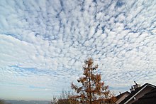 Altocumulus stratiformis over Germany in 2011 | |
| Abbreviation | Ac str |
| Genus | Altocumulus (high, heaped) |
| Species | stratiformis |
| Variety |
|
| Altitude | 2,000 - 6,000 m (6,500 - 20,000 ft) |
| Classification | Family B (Medium-level) |
| Appearance | Patchy and shallow; often semi-transparent. |
| Precipitation cloud? | Uncommon |
Altocumulus stratiformis is the most common species of the Altocumulus genus of clouds.[1] They tend to form broad layers of individual, cell-like clumps, often separated from each other, though they sometimes can coagulate into a larger individual cloud. They often have a vertical extent of less than 500 m.[2] Due to their formation dynamics, they are commonly associated with the imminent arrival of precipitation.
Formation[]
The presence of stratiformis clouds in the mid-levels of the atmosphere is indicative of some instability at that level;[3] atmospheric pressure falls, often associated with nearby systems of low pressure, can depress the altitude of stratiformis into the lower atmosphere, often evolving into Nimbostratus clouds, which precipitate. [4] Altocumulus stratiformis clouds may also form when a cold front is approaching, due to the difference in air masses.
References[]
- ^ "Altocumulus stratiformis (Ac str)". International Cloud Atlas.
- ^ "Altocumulus Stratiformis Clouds - EPOD - a service of USRA". epod.usra.edu.
- ^ "Altocumulus clouds". Met Office.
- ^ "Nimbostratus Clouds: dark, low-level clouds with precipitation". ww2010.atmos.uiuc.edu.
This cloud–related article is a stub. You can help Wikipedia by . |
- Cumulus
- Atmospheric science stubs